
|
|
Mountain/Rock |
|---|---|
|
|
46.09390°N / 7.85900°E |
|
|
14911 ft / 4545 m |
|
|
Overview

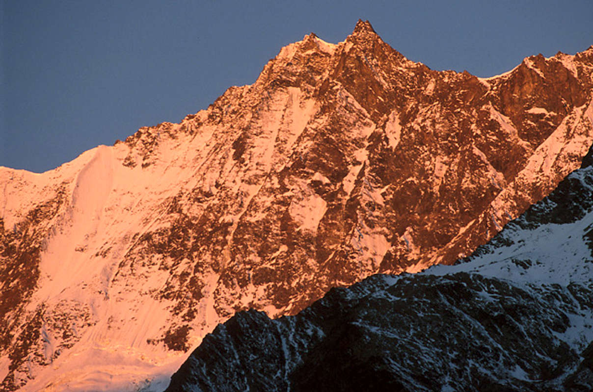
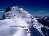
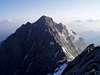
Dom – correct name Dom de Mischabel – is a massive and impressive mountain at the mid-length point of the Mischabel Chain, between its twin Taschhorn (mts. 4491) to South and the pyramid of the Lenzspitze (mts. 4294) to North. It is the highest point of the Strahlhorn-Mischabel Group and the third peak of the Alps after Monte Bianco and Monte Rosa - even if Dom it is lower than Dufour, Nordend, Zumstein and Punta Gnifetti (Signalkuppe).T
he Dom is the highest mountain completely in Swiss territory (because Dufour is the highest summit completely in Switzerland.Dufourspitze is not located on the Monte Rosa ridge, which forms the frontier between Italy in Switzerland, but one hour away to the west but several Swiss summits of the frontier Monte Rosa exceed the Dom in height by as much as 260 feet).
SUMMITS and SUB-SUMMITS
The name “Mischabel” comes from a ancient German dialect term for “pitchfork for the manure” and it was the former name of the Dom, even if during years the name entitled all the Chain.
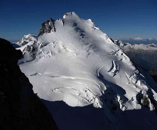
What makes folks call this summit the “pitchfork” is the presence of many peaks close to each-other, in fact Dom has one main peak and two secondary peaks:
the highest one (with a cross) lies in the middle, it is 4545.42 meters height with a trapezium shape (if viewed from North or South).
the Western one is so-called “Gabel” and it represents the Dom’s antisummit: it is 4480 mts. high.
the Eastern one is the summit of a Grand Gendarme with a 4468 mts. elevation.
RIDGES and SADDLES
The Dom’s shape is quite complex and it presents five ridges:
The least important and briefest one is the summit ridge between the Dom summit and the Gabel (Dom’s antisummit) and it is 230 m length.
The two main ridges are the NNE and the S, almost lined-up these ridges links Dom to the Lenzspitze – (toward N), and to the Taschhorn up to the Alphubel and the Allainhorn (toward S), creating a great wall in the E side of the Mischabel · Stahlhorn Group, covered by the large Feegletscher; on the NNE just under the Lenzspitze southern side there is the Lenzjoch, while on the S ridge there’s the Domjoch (the pass between Dom and Taschhorn): both of these passes are narrow and difficult to get over.
The other two, W and NW run almost parallel from the summit ridge, creating three areas on the W side of the Dom; on the NW ridge there is the Festijoch a large saddle opened on the Festigletscher (at S) and the Hohberggletscher (at N).
SIDES
The system of ridges all around the Dom’s summit creates four main sides for this mountain:
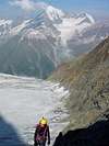
The most important one is the E wall, impressive, steep and icy (it is covered by the Feegletscher= Fee Glacier), continues from the Allalinhorn to the Lenzspitze, above the village of Saas Fee
the SW side is also icy, covered by the Kingletscher.
the N side is completely icy, covered by the Hohberggletscher, and here the Normal route runs.
the W side is icy, held between the W and NW ridges, and covered by the Festigletscher.
THE NAME
Its name could be come from a dialect term for “dome” or “cathedral” but someone says that the name Dom comes from the name Domherr (German term near “priest”) Berchtold, the first man to measure the heights of the Mischabel.
Note: desainme (Mark) having maintained this page and that of the Lenzspitze for five years, does not pretend to having been to these mounains but has attempted to maintain the page by incorporating the messages of those who have. If any Sper having "experienced" the Mischabel wishes to assume responsiblity for this plaease let me know.
 |
 |
 |
 |
 |
Getting There
FROM MATTERTAL
The Mattertal Valley is easy to reach from any places of Switzerland and Italy too.
~ From Geneva drive along the A1 up to Losanne, then take the A9 up to Visp. Easy speedways. In Visp is suggested to leave the own car and take the cable-train up to Zermatt, or as arrived to Visp drive in the Valley up to Tasch (the last car allowed point) then take the train. 236 kms, 3 h.
~ From Bern take the A12 up to Montreaux, on the Geneva Lake, then the A9 up to Visp. Easy speedways. In Visp is suggested to leave the own car and take the cable-train up to Zermatt, or as arrived to Visp drive in the Valley up to Tasch (the last car allowed point) then take the train. 231 kms, 3 h.
~ However, if you’re moving from Italy, as arrived to Aosta (see Monte Rosa Group or Monte Bianco di Courmayeur pages) drive to north by the E27 – S27 road up to Martigny, where take the A9 up to Visp. In Visp is suggested to leave the own car and take the cable-train up to Zermatt, or as arrived to Visp drive in the Valley up to Tasch (the last car allowed point) then take the train. 180 kms, 2 h 50 m
Refuges of the Group could be reached with lift-ways from Randa (on the road to Zermatt) and Zermatt, like: Gasenried, Randa Alpin, Taschalp.
FROM SAASTAL
Also the Saas Valley is easy to reach, like Mattertal Valley you’ve to move up to Visp then Stalden where the Saas Valley divides itself Mattertal Valley.
~ From Geneva drive along the A1 up to Losanne, then take the A9 up to Visp. Easy speedways. In Visp move up to Stalden, then enter the Saastal and arrive to Saas Fee, where many lift-ways stations lie. 226 kms, 2 h 50 m.
~ From Bern take the A12 up to Montreaux, on the Geneva Lake, then the A9 up to Visp. Easy speedways. In Visp move up to Stalden, then enter the Saastal and arrive to Saas Fee, where many lift-ways stations lie. 222 kms, 2 h 50 m.
~ Again, if you’re moving from Italy, as arrived to Aosta (see Monte Rosa Group or Monte Bianco di Courmayeur pages) drive to north by the E27 – S27 road up to Martigny, where take the A9 up to Visp. In Visp move up to Stalden, then enter the Saastal and arrive to Saas Fee, where many lift-ways stations lie. 162 kms, 2 h 30 m.
Main refuges of the Mischabel Group could be reached with lift-ways from Saas Fee, like: Langflue, Felskinn, Metrò Alpin to the Mittelallalinstation for the approaches to the main summits of the Group.
~ For the snow / avalanches conditions go to the website:
SWISS SERVICE FOR AVALANCHE CONDITIONS
 |
 |
 |
 |
 |
Routes
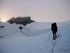
Dom is usually reached by the non-difficult N side, by steep icy slants, but very frequented is also the Taschhorn-Dom traverse (in this way), difficult but very gainful, with a descent along the normal.
Easy is also the Lenzspitze-Dom traverse (in both the ways), but it is less frequented than the other one because is not very gainful, but anyway interesting.
Both of these two traverses belonged to the famous Mischabel Chain Great Traverse, the remarkable route from Taschhorn (moving from the Mischabeljoch Biwak) to the Bordierhutte.
The glacial E face and the exposed NE ridge are nor very frequented because they present a series of important objective-hazards.
However the best period for the Dom’s ascensions is the Summer time, from June to September, but with settled conditions.
Important: all the approaches are however long and binding.
The first ascension of the Dom belongs to J. L. Davies, J. Zumtaugwald, J. Kronig and H. Brantschen – September 11, 1858 by the NW Ridge (Festigrat).
? N SIDE (Normal)
~ Start point
Domhutte, m. 2940
~ Type
steep completely icy routes, usually marked.
~ Difficult and inclination
PD, passages of II+ (preferable double for the descent)
? NW RIDGE (Festigrat) – Also linked to the Lenzspitze Traverse (Festigrat)
~ Start point
Domhutte, m. 2940 or Lenzspitze, m. 4249
~ End point
Dom, m. 4545
~ Type
mostly rocky ascension, on Gneiss often friable, exposed and windy, possible ice passages.
~ Difficult and inclination
- from Domhutte, mostly AD, with passages of III+
- from the Lenzspitze, mostly PD +, two particular passages of III up to the Lenzjoch then AD, with passages of III+
~ Mischabel Chain Great Traverse
Mischabeljoch Biwak – (AD+) – Taschhorn – (D / D+) – Dom – (AD / PD+) – Lenzspitze – (AD+ / D-) – Nadelhorn – (AD+) – Stecknadelhorn – (PD+) – Hohberghorn – (D / D+) – Durrenhorn – (AD+) – Bordierhutte,
or
Mischabeljoch Biwak – (AD+) – Taschhorn – (D / D+) – Dom – (AD / PD+) – Lenzspitze – (AD+ / D-) – Nadelhorn – (AD+) – Durrenhorn – (AD+) – Bordierhutte.
W face: Several routes across the ice west face: ice, 55 degrees inclination and some rock climbing III near the top of the west face, D/D+. Notation by [X] Bird
? S RIDGE (Taschhorn - Dom Traverse , Domgrat)
~ Start point
Taschhorn, m. 4491
~ Type
very exposed, windy, friable Gneiss rocks, snowy-frames
~ Difficult and inclination
D (but also D+) with passages of III, III+ up to IV+ (due to rocks conditions)
~ Mischabel Chain Great Traverse
Mischabeljoch Biwak – (AD+) – Taschhorn – (D / D+) – Dom – (AD / PD+) – Lenzspitze – (AD+ / D-) – Nadelhorn – (AD+) – Stecknadelhorn – (PD+) – Hohberghorn – (D / D+) – Durrenhorn – (AD+) – Bordierhutte,
or
Mischabeljoch Biwak – (AD+) – Taschhorn – (D / D+) – Dom – (AD / PD+) – Lenzspitze – (AD+ / D-) – Nadelhorn – (AD+) – Durrenhorn – (AD+) – Bordierhutte.
? NE RIDGE (Gran Gendarme de Dom)
~ Start point
Domhutte, m. 2940
~ Type
very exposed, windy, friable rocks, cracks, mobile-blocks
~ Difficult and inclination
D+, with passages of IV and IV+
? E FACE
~ Start point
Domhutte, m. 2940
~ Type
difficult ice (also rocky) route, ribs, spurs, stone falls, icy falls, couloir, very crevassed slants.
~ Difficult and inclination
D+
E face: routes on the east face usually do not start from the domhutte but from the cablecar station at Langflue Notation by [X] Bird
Dom map route from Domhutte via Festijoch
http://www.bielefeldt.de/mischabele.htm
Mischabel by Hartmut Bielefeldt
 |
 |
 |
 |
 |
Huts
BIVOUACS
in order: name, height, location, municipal district, owner. Open all year long.
1. MISCHABELJOCH BIWAK, m. 3860, Mischabeljoch, CAS Geneva, 30 beds – reach it by the W face of the Mischabel Chain, just South of the Taschhorn, mix and ice with PD+ difficult (use trad. equipment)
REFUGES
in order: name, height, location, municipal district, owner, refuge phone, beds (winter room those signalled with a +). Open in summer.
1. MISCHABELHUTTE, m. 3329, NE spur of the Lenzspitze, AAC Zurich, Tel.: (+41) 028.571317, 60 beds – reach it from Saas Fee (Saastal) with an easy path in 3.30 / 4 hours, well signalled, difficult: T / E
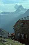
2. DOMHUTTE, m. 2940, Festigletscher, Sec. UTO of CAS, Tel.: (+41) 028.672634, 52+5 beds – reach it from Randa (Mattertal) with a steep path in 4 / 4.30 hours, difficult: E
3. LANGFLUE, m. 2870, Langflue, CAS Saas, Tel. : 028.48132, 80 beds. – reach it easily from Saas Fee with comfortable cable-cars
4. HOTEL FLUH, m. 2618, Findelgletscher, private, Tel.: 028.77551, 60 beds - reach it easily from Saas Fee with comfortable cable-cars
5. TASCHHUTTE, m. 2701, Rotgrat, UTO of CAS, Tel.: 028.673913, 60 beds
This page is been developed following the:
CONTRIBUTORS
Zermatt city-hall
Saas Grund city-hall
TCI Touring Club Italiano – Italian Alps Costumers Service
BOOKS AND MAPS
CAR MAPS
Atlante automobilistico Italia settentrionale, 1:200000 – Touring Club Italiano, 1979
Route Planner Europe software, 1:96 – Sony Italia and TCI, 2000
TERRITORY MAPS – ROUTE MAPS
Matterhorn – Monte Rosa – Mischabel, C. 3 No. 5006, 1:50.000
CNS Zermatt and Mattertal, No. 1348, 1:25.000
CNS Saastal and Mischabel, No. 284 S, 1:50.000
BOOKS
Alpes Valaisannes. Du Strahlhorn au Simplon, vol. 4
Guida al Monte Rosa: Club Alpino Italiano, vol.1-2
Guida al Gruppo dei Mischabel: Club Alpino Italiano, vol.U
Manuale di alpinismo CAAI – Le Alpi Pennine, il Gruppo del Monte Rosa, i Mischabel
Mischabel Cam
Dom Hut
Mischabel Hut
Tasch Hut
Hotel Langflue
Berghaus Flue
Dom et al. from Britannia Hut
 |
 |
Villages and where to stay
SAAS FEE
Village in the Canton of Valais (Wallis), Switzerland. 1809 inhabitants, 1803 meters height, in the Saas Valley
- Car traffic close
- Postale Code: 3920
- Dialling Code: (+41) 028-
- Tourist office, Tel.: (+41) 028.571457
- Informations:
saastal.ch
weissmies.ch
swiss railways
cable-cars, Tel.: 028.571414
lift-ways “Metrò Alpin”, Tel.: 028.572717
to sleep, Tel.: 289571440
ZERMATT
Village in the Canton of Valais (Wallis), Switzerland. 3548 inhabitants, 1616 meters height, in the Mattertal Valley
- Car traffic close
- Postale Code: 3920
- Dialling Code: (+41) 27-
- Tourist office, Tel.: (+41) 027.672828
- Informations: to the Tourist Office, tel.: 27.9668100,
e-mail
zermatt.ch
swiss railways
train Brig-Visp-Zermatt, Tel.: 027.672828
 |
 |
 |
 |
When to climb
Ascensions possible all the year long, especially along the Normal (N side) or the more binding Festigrat (NW ridge) also linked to a beautiful Lenzspitze-Dom traverse, paying attention, an amazing experience especially in autumn and winter times.
Other routes to Dom are difficult and each one requires good preparation, settled weather conditions for the presence of many objective-hazards such as rock fall or recent snowy layer.
It’s an important suggestion to say that Dom routes shall be started by the very early morning.
 |
 |
Mountain Conditions
~ For the weather conditions go to the website:
GERMAN SERVICE FOR ALPS WEATHER CONDITIONS
Swiss weather meteo
~ For the snow / avalanches conditions go to the website:
SWISS SERVICE FOR AVALANCHE CONDITIONS
http://www.slf.ch/avalanche/avalanche-en.html
Swiss snow conditions
Red Tape
There are no seasonal closures or necessary permits.
Is quite important say that Zermatt is unreachable by cars. Who want to move in the Mattertal up to Zermatt must to leave his or her own car in Visp, or in the Stalden village and continue with train, the best way could be parking in Visp.
The same for Saas Fee, but it is easier than Zermatt to be reached, cars can reach the village but they can’t move in it.
Bibliogaphy, links, photos and maps
This page is been developed following the:
CONTRIBUTORS
Zermatt city-hall
Saas Grund city-hall
TCI Touring Club Italiano – Italian Alps Costumers Service
BOOKS AND MAPS
CAR MAPS
Atlante automobilistico Italia settentrionale, 1:200000 – Touring Club Italiano, 1979
Route Planner Europe software, 1:96 – Sony Italia and TCI, 2000
TERRITORY MAPS – ROUTE MAPS
Matterhorn – Monte Rosa – Mischabel, C. 3 No. 5006, 1:50.000
CNS Zermatt and Mattertal, No. 1348, 1:25.000
CNS Saastal and Mischabel, No. 284 S, 1:50.000
BOOKS
Alpes Valaisannes. Du Strahlhorn au Simplon, vol. 4
Guida al Monte Rosa: Club Alpino Italiano, vol.1-2
Guida al Gruppo dei Mischabel: Club Alpino Italiano, vol.U
Manuale di alpinismo CAAI – Le Alpi Pennine, il Gruppo del Monte Rosa, i Mischabel
Quick glance
Mischabel Elevation Val de Saas huts Val de Matt huts
Nadelhorn 14,196 yes Bordierhutte
Lenzspitze 14,088 Mischabelhutte Saas
Dom 14,911 yes Domhutte
Taschorn 14,733 Taschalp
External Links
- Site of Randa
Misc. information. - Dom at www.4000er.de
Images, routes, coordinates and more information about the highest peaks of the Alps
Ski Rando ( Ski Mountaineering)
Gabrielle has suggested that there is much opportunity for this starting from the month of May into summer. Much of it appears to be from the Sass Fee side. Note that there are cable cars into the mountains from this side.
desainme - May 11, 2004 9:35 am - Hasn't voted
Untitled CommentA fall of several hundreds of meters as he was climbing un-roped along the ridge that unites the Tãsch-horn with Sunday (4,545 ms, the Swiss Alps), not far from Mt.Cervin(Matterhorn), took yesterday to Wednesday 28 of April the life of Patrick Berhault. The body of the French mountain climber has been found to first hour of today Thursday by the rescue teams, and transferred to Zermatt.
Berhault, of 47 years, was in the final course of his present adventure in the Alps, next to his friend and companion of the rope in the last three years , Philippe Magnin, who was also evacuated yesterday by helicopter to Zermatt. Magnin, who after losing sight of Berhault decided to return to the security of the bivouac of Mischabeljoch, has declared that not to fall . "I saw him slide down for 50 meters, before disappearing into the fog".
They tried to crown a new top within its present project: the 82 4000 meter peaks of the Alps in 82 days (the last one had been the Tãsch-horn), and according to Magnin "for us were a easy land". They went quickly unroped and all that wa required to to chain 82 tops in the Alps in this time. "the cord only we used was to rappel".
Patrick Bérhault
Berhault was a key figure of rock climbing and alpinism in the eighties decade in he which enjoyed all the facets the mountain (precursory next to Edlinger of sport and the high difficulty, author of important linkings in the Alps, balloonist of the first in artificial and "homemade" acclimatization, protagonist of films and spectacles of dance-climbing...), except for its competitive side (it always signed and it fulfilled the famous " Manifesto of to the 19 ").
Patrick did not seem to have changed much since then, when he affirmed that he preferred the rocks with earth and vegetation to be able to feel closer to nature. He did every day in his farm, with his family, "in close contact with the nature", something that put in front without doubting it to the scaling, but that did not let look for in its last alpine excursions.
In fact, he got to confess to Jean Michel Asselin, editor head of the Vertical French magazine (to see Unevenness 175), that the passage to the made alpine arc next to several companions (Humar, Edlinger, Magnin...) between 2000 and 2001, the Alps arose first of all because him "it had desire to the Alps,". He wanted to impress himself "of his landscapes, their stations. To know the other climbers, to the guards of the refuges, the people who live in those mountains. And also the history of the Alps through its more significant routes ". Yes, in the heat of to look for the adventure in the Alps century XXI.
To walk searching carefully
Because "the originality, the creativity, the ' new one will aventure, walking searching carefully" they were always basic terms in the conception that Patrick Berhault had of the mountain and the climbing. Aspects that always interested to him: "the scaling and the mountain are also the adventure, the adaptation, in which often there are unexpected risks to which we must try to do in front, because that form leaves from the game".
Those risks, and that mentality, changed with time, even before having a family. "To make abstraction voluntary of all danger, although it perceived them and it had certainty of them, it let interest to me, and it began to me to seem an absurd one, a lack of intelligence and respect". Not only in front of the wanted people, also in front of the mountain. Yesterday, that mountain that as much it loved and it respected took it of unexpected form, for all.
Quickening, speed, and linkings were three constants in their sport curriculum. His was modest also. Like sport climbers, he was the king of quickening in the first eighty. Its Devers film marked. It was, surely, the first shooting of the world dedicated completely to the scaling towards the bad side. Figures of climbing such as Edlinger or Güllich never let confess their admiration by Berhault and its lines of Monaco, specially Ceiling of Augusta and Perife'rica the west . He was one of the first climbers for whom the gade of 8c was proved...
In the Alps, speed and linkings marked their time in much of their bulks (Ecrins, Oisans, Valais...), and specially in the Mont Blanc. He had like companions to first European figures, such as Patrick Gabarrou or Patrick Cordier, among others, and their activity, some of the best times soloing tthe Integral of Peuterey or the Droites continues in his name. Remembering words of our own Patrick, with his more original linking, "the South face of the Fou and the direct way on the Drus, returning to Chamonix in the day, and making flights with a parasail in company of Jean Marc Boivin" and others of his adventuring companions.
alpenkalb - Aug 5, 2004 9:46 am - Hasn't voted
Untitled CommentYou write:
" Dom it is the highest mountain completely in Swiss territory (because Dufour is the highest summit in Switzerland but not the highest mountain).
SUMMITS and ANTISUMMITS".
Please explain. Dufour is higher, completely in Swiss territory (not located on any borderline). Of course its geological root reaches down to Italy. So does Mt. Blanc.
[X] Bird - Jan 11, 2007 3:26 pm - Voted 10/10
Error's in route descriptionsThere is an error's in the route descriptions: E face: routes on the east face usually do not start from the domhutte but from the cablecar station at Langflue There is also a description missing: W face: Several routes accros the ice west face: ice, 55 degrees inclination and some rock climbing III near the top of the west face, D/D+.
desainme - Jan 28, 2007 5:59 pm - Hasn't voted
Re: Error's in route descriptionsI have added your notations to the route section