With the help of Livioz the panoramic views have been transformed into interactive ones, that is to say the names of summits and glaciers are displaced moving slowly the mouse over them (nov 08th, 2004)
Tested the correct behaviour of the interactive panos with the browser: IE6, Netscape7 and Opera 7, notwithstanding some differences. The previous version of Opera 6.4 doesn't seem to work properly. Added new images (Nov 09th, 2004)
added new photos and changed signature pic (Nov 10th, 2004)
made some changes to the look of the page, attached other thumbnails, improved the interactive images (nov 11th, 2004)
finished, at the moment, the posting with the addition of a fourth interactive pano and other minor changes (Nov 12th, 2004)
updated the page by Livioz using some facilities of SPv2 (May 26th, 2006)
Overview
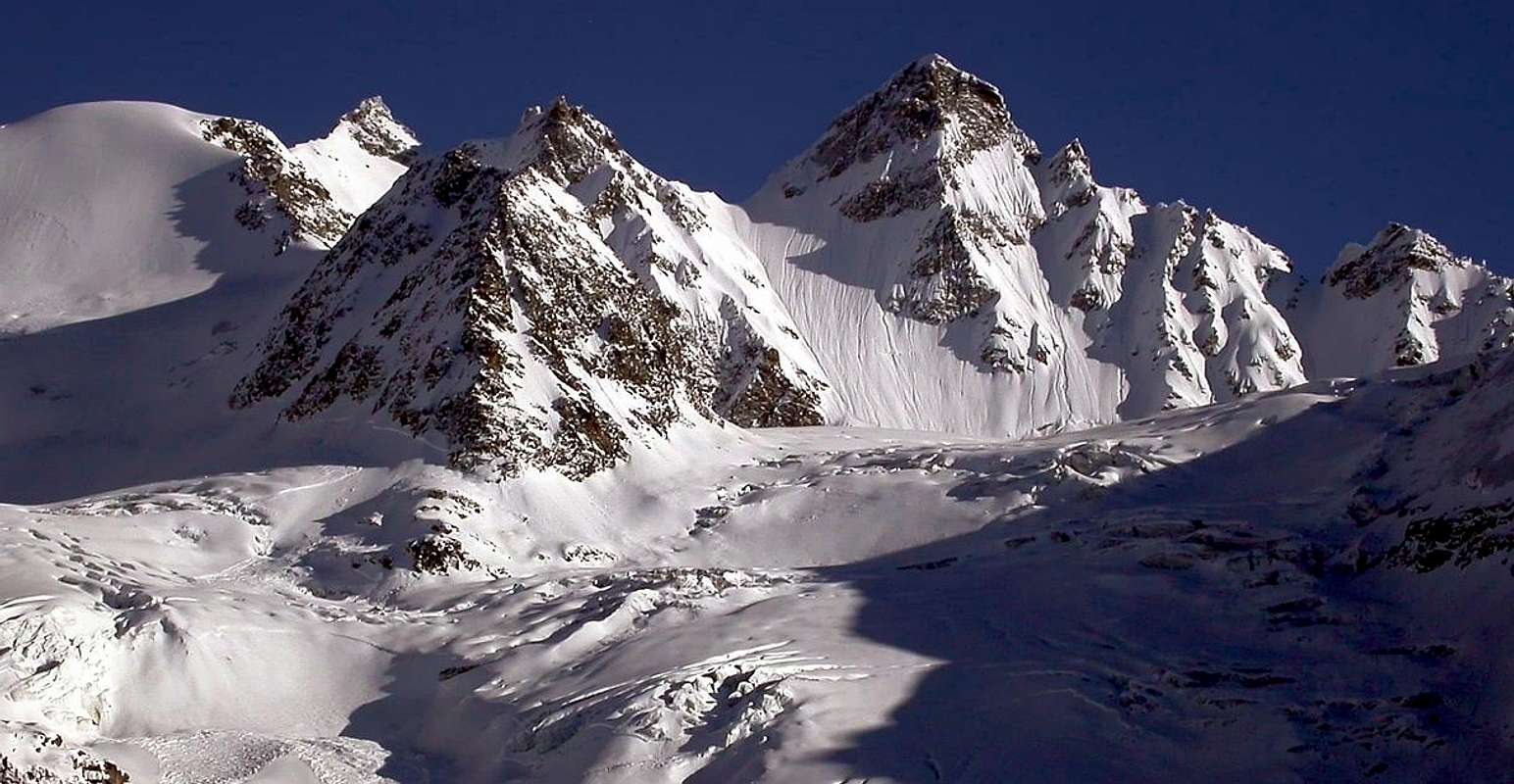
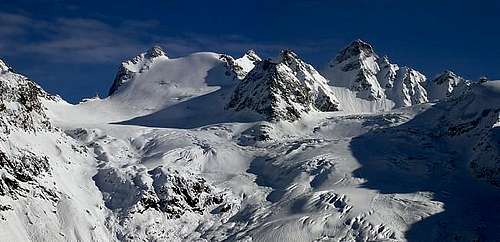
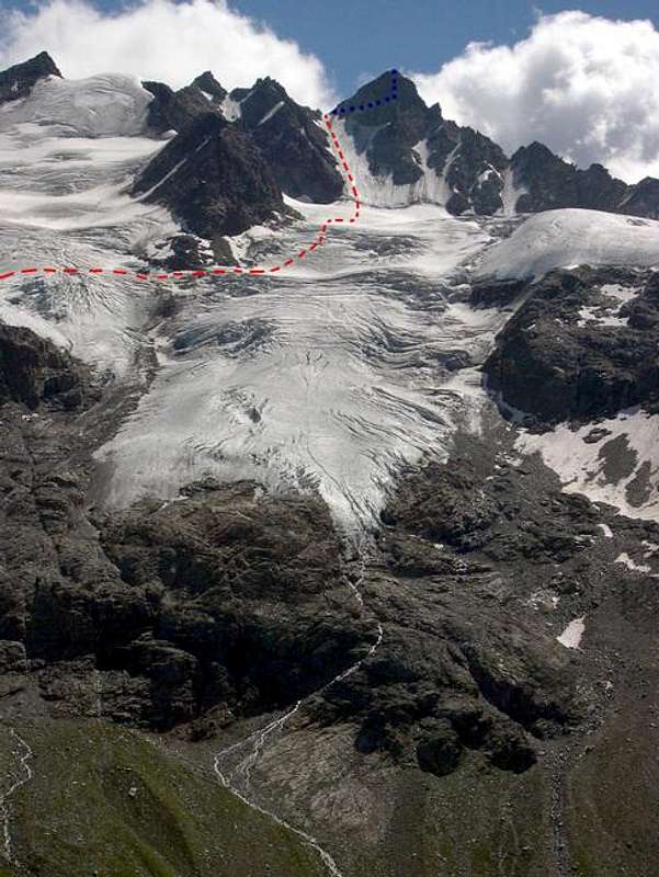
One cannot make out the Torre del Gran San Pietro (Tower of the Great Saint Peter) from Cogne (1.534m) or from the floor of Valnontey, even though, at 3.692 meters, it is the highest Summit of the Apostoli Range (a subgroup of the Gran Paradiso Group). On the other hand, since it is placed approximately at the center of the long ridge between Valnontey and Valeille, just in front of Gran Paradiso, the summit becomes perfectly visible when going up to the Herbetet Huts or to the Sella Refuge (in the Lauson Basin), so that its beauty can be easily admired. Many glaciers lie at its foot: to the west the vast Money Glacier, divided by the Paganini Ridge (3.440m) from the nearby Coupé di Money Glacier; to the South the smaller Teleccio Glacier and to the East the two branches of Valeille Glacier. The views from its summit are wonderful.
Non si può scorgere la Torre del Gran San Pietro da Cogne (1.534m) o dal pianoro della Valnontey, anche se, con i suoi 3.692 metri, è la Vetta più alta della Catena degli Apostoli (un sottogruppo del Gruppo del Gran Paradiso). D'altra parte, dal momento che è collocato approssimativamente al centro del lungo crinale tra i Valloni della Valnontey e della Valeille, proprio di fronte al Gran Paradiso, il vertice diventa perfettamente visibile quando si raggiungono le baite dell'Herbetet, oppure dall'appena soprastante Rifugio Sella (nel Vallone-bacino del Lauson), in siffatto modo che la sua bellezza può esserne facilmente ammirata. Molti ghiacciai si trovano ai suoi piedi: ad Ovest il vasto Ghiacciaio di Money, diviso in due dallo Sperone Occidentale della Cresta Paganini (3.440m) tal da separarlo dal vicino Ghiacciaio di Coupé de Money; a Mezzogiorno si colloca il più piccolo Ghiacciaio del Teleccio, mentre ad Oriente si estendono i due rami del Ghiacciaio di Valeille. Meravigliosa la vista dalla sua Sommità.
First Ascents
First on the summit: D. W. Freshfield, C. C. Tucker, T. H. Carson, J. H. Backhouse, D. Ballay and M. Payot, (Jul 14th, 1867).
In winter: E. Adami, P. and S. Ceresa, (Jan 21th, 1935).
S-W Arête: P. E. Lord, G. Yeld, F. and S. Pession, (Aug 19th, 1894).
N-W Wall: W. M. and R. Pendlebury with G. and J. Spechtenhauser, (Jul 19th, 1876).
N-W Wall: Aldo Bignamini, Gino Costa, Bruno Martinazzi and Leopoldo Saletti, (Jun 28th, 1941).
W Slope and N Arête: E. Carr and A. F. Mummery, (Aug 12th, 1891).
W Couloir (Directly to N-NW Face): Osvaldo Cardellina, Sandrino Casalegno and Maurizio Castellan, (Jul 22th, 1984).
E Wall: W. M. and R. Pendlebury with G. and J. Spechtenhauser, (Jul 19th, 1876), in descent.
E-SE Arête: C. Alberico, E. Adami, L. Borgna and P. Ceresa, (Jul 19th, 1933).
S Wall: L. Vaccarone and J. J. Maquignaz, (Aug 22th, 1875).
Getting There
BY CAR:
Approach from North
From Torino, Milano, etc: Motorway A5. Exit in Aosta Ovest. Drive to the near Aymavilles. Follow in the direction of Valle di Cogne.
From Switzerland: through the Grand St. Bernard Tunnel or the homonym Pass. Drive to Aosta, then follow Courmayeur direction on SS.26. Just after Sarre, turn to the left, in the direction of Valle di Cogne.
From France: through Mont Blanc Tunnel or Petit St. Bernard Pass. It isn't necessary to enter in Motorway A5, you can drive through SS.26 Aosta direction. Before arriving at the Village of Sarre, follow the sign and turn right towards Valle di Cogne.After Aymavilles, the SR.47 crosses the Villages of Vieyes, Epinel and Cretaz and after about 25 Km. arrives at Cogne (1.534m). From Cogne, by bus or by car, till the Village of Valnontey (1.666m).
Approach to southern valleys of the Gran Paradiso Group (Piantonetto and Noaschetta)
Coming from Torino: autoroute to Aosta - till to S. Giorgio Canavese or take the Road SS.460 to Ceresole Reale. When you arrive at Rosone Village (16 km to Pont Canavese) take a little road on the right, see the sign "Piantonetto Valley". Go till to Teleccio Lake (1.870m), where the carriage road ends, and park your car.
BY PLANE:
Aeroporto "Corrado Gex" Saint Christophe (Aosta).
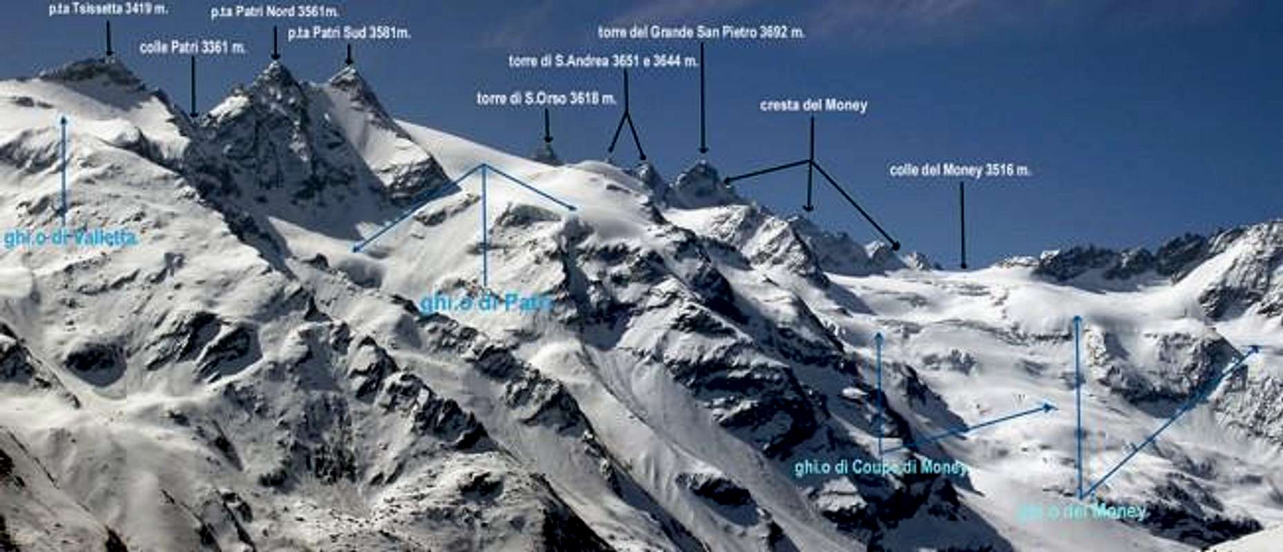
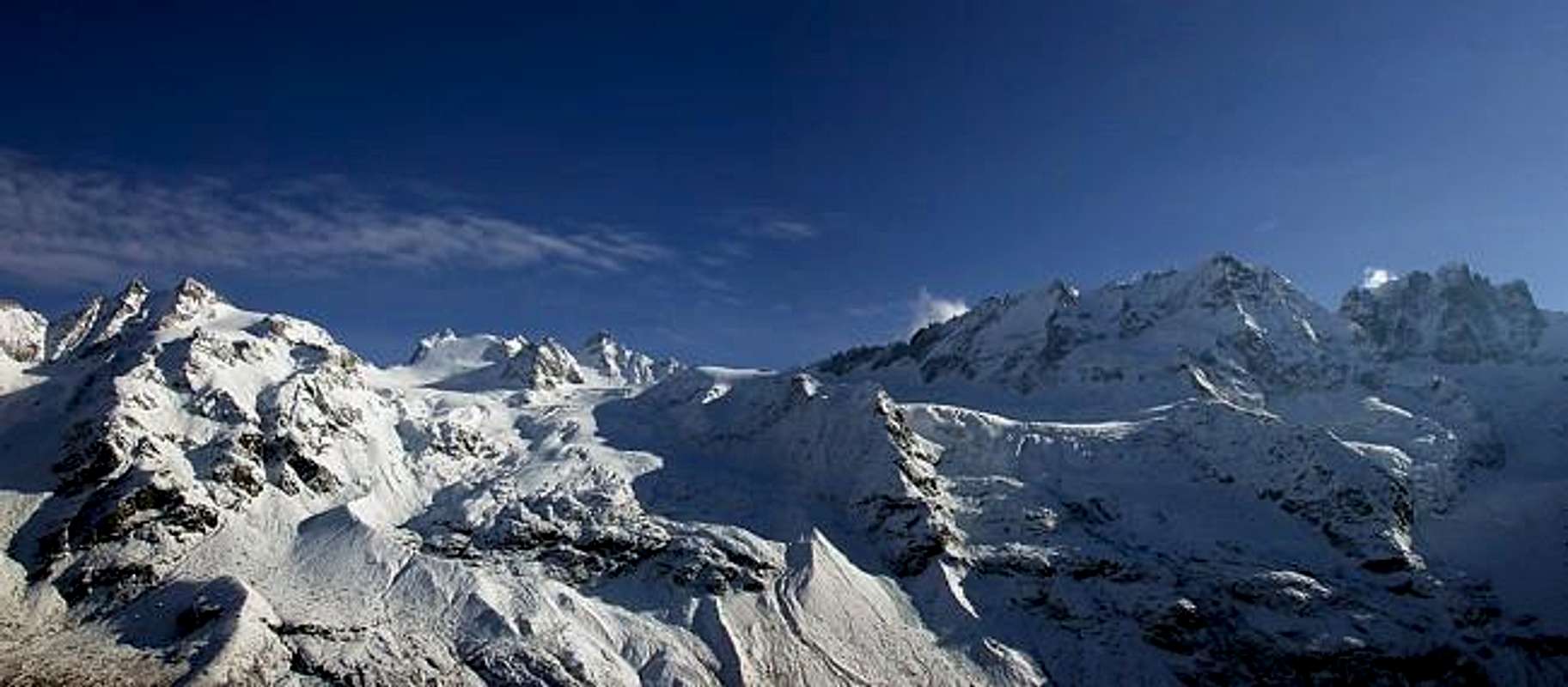
Labelling of glaciers and summits belonging to the ridge Valnontey-Valeille
Route to the Money Bivouac (2.872m)
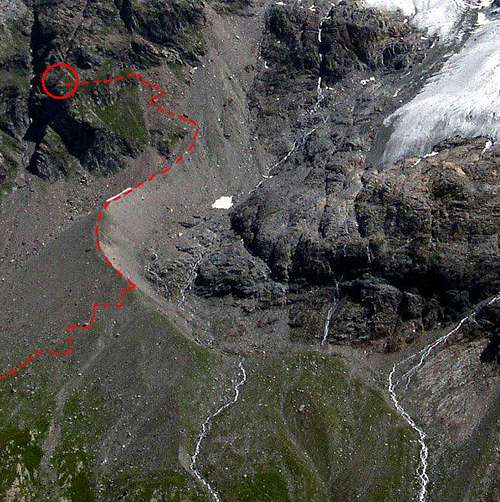
From the Village of Valnontey (1.666m) follow the easy trail going up along the valley. After the pleasant Hamlet of Valmiana (1.728m) continue, always gently uphill, till a fork (0h'45). Turn left, following the trail to the Money Huts, which begins to rise steeply. After 1h'00/1h'15 a long traverse brings one in view of the Money Huts (ruins) at 2.325 meters. Shortly before reaching them, turn left and go towards the ridge of the side moraine of the Coupé di Money Glacier. Follow the panoramic ridge of the moraine to its end, cross towards left a field of talus and broken rocks; with the help of a fixed rope climb a short gully, then a somewhat exposed path leads quickly to the bivouac, easily distinguishable since it is (or, better, it was) painted yellow. The bivouac, placed at 2.872meters (3h'45/4h'00) from Valnontey), is in a very panoramic position with respect to the Gran Paradiso central chain.Drinkable water may be found at a short distance above the bivouac, coming from Patrì Glacier.
Dal villaggio di Valnontey (1.666m) si segue facilmente il sentiero percorrente la valle. Dopo i piacevoli Casolari di Valmiana (1.728m) si continua, sempre in leggera salita, fino ad un bivio (0h'45). Voltare sulla sinistra, seguendo il sentiero che si indirizza alle Baite del Money, ove inizia a salire decisamente più ripido. Dopo 1h'00/1h'15 un lungo traverso porta uno in vista dei ruderi delle Baite del Money a 2.325 metri. Poco prima di arrivarvi, svoltare sulla sinistra proseguendo verso la cresta della morena laterale del Ghiacciaio Coupé de Money. Seguirne la cresta panoramica sino al suo termine, quindi attraversare verso sinistra un tratto di detriti e rocce rotte; con l'aiuto d'una corda fissa salire una breve gola, poi con percorso alquanto esposto portarsi rapidamente al bivacco, facilmente distinguibile dal momento che appare (o, meglio, era) verniciato in giallo. Il bivacco, posto a 2.872meters (3h'45/4h'00) da Valnontey), è in una posizione molto panoramica rispetto alla catena centrale del Gran Paradiso. L'acqua potabile può essere trovata a breve distanza sopra il bivacco; la stessa proveniene dal Ghiacciaio di Patrì.
Route to the Torre del Gran San Pietro Summit (3.692 m)
Since my own climb of the Torre del Gran San Pietro, which dates back to the early 70's, the conditions of the glaciers have substantially changed. Therefore, I prefer not to post a separate technical route description, but rather give a general overview here.
Poiché dalla mia scalata della Torre del Gran San Pietro, risalente ai primi anni '70, le condizioni dei ghiacciai sono notevolmente cambiate, preferisco inserire qui una descrizione del tragitto più che tecnica di indirizzo generale.
Starting from the Money Bivouac, head toward the orographic right side of the Coupé di Money Glacier; cross it diagonally, aiming for the foot of the Paganini Ridge. Go around the ridge, and proceed along the Money Glacier towards the ice chute of the west face. (Pay attention to the many crevasses that sometimes force one to make tiresome detours.) With caution, get over the terminal crevasse and begin to climb the slopes (about 300 meters) with an angle around 45 degrees. (Be careful: the final cornice could be very thin; therefore, remain some meters below it.) At this point go right for a few meters to reach the Northwest Face of the mountain: now, if you have not already done so, put on your helmet. With caution, head for the center of the East Face (which descends rather steep for 600 meters towards the Valeille Glacier, with loose rock), climb the final dihedral, 50 meters long, paying attention to "verglass2. (Besides, if they haven't been removed, don't use absolutely the old pegs or slings because they are not safe). At last, one arrives on the thin Summit at 3.692 meters, where a metal cross has been placed (4h'00/4h'30 from the bivouac). Descend along the same route.
The route, classified AD, is to be undertaken by expert climbers in good physical conditions.
Partendo dal Bivacco Money, dirigersi verso il lato destro orografico del Ghiacciaio Coupé de Money; attraversarlo diagonalmente, mirando alla base Occidentale della Cresta Paganini. Percorso l'intero crinale, si prosegue attraverso il Ghiacciaio di Money verso lo scivolo ghiacciato della Parete Ovest. (Prestare attenzione ai numerosi crepacci che a volte costringono a deviazioni fastidiose.) Con cautela, superare la terminale e cominciare a scalare lo scivolo iniziale di circa 300 metri con una pendenza di all'incirca 45 gradi. (Attenzione: la cornice finale potrebbe essere molto sottile, quindi é cosa buona procedere alcuni metri al di sotto.) A questo punto traversare a destra per pochi metri raggiungendo la Parete Nordovest della montagna: ora, se non l'avete già fatto, é meglio mettere il casco. Con cautela, aggirarne la parte più elevata portandosi al centro della Parete Est (che scende piuttosto ripida per 600 metri sopra il Ghiacciaio Valeille con rocce non sempre compatte); scalarne il diedro finale di circa una cinquantina di metri, facendo attenzione alla possibilità di presenza di "verglass". (Inoltre, se non sono stati rimossi, non utilizzare assolutamente i vecchi infissi perché non sempre sicuri). Alla fine, s'arriva sulla piccola Vetta a 3.692 metri, ove v'é posta una croce di metallo (4h'00/4h'30 dal bivacco). Discesa lungo lo stesso percorso. Si evidenzia che questa salita deve essere intrappresa da alpinisti esperti ed in buone condizioni fisiche.
Equipment
High mountain equipment, rope, axe, crampons, helmet, a few rock and ice pegs (even if not used).
Attrezzatura d'alta montagna con corda, piccozza, ramponi, casco, un paio di chiodi da roccia e da ghiaccio (anche se non sempre utilizzabili).
When To Climb
From July to September, usually.
Normalmente dal Mese di Luglio fino a quello di Settembre.
Red Tape
Inside the borders of the P.N.G.P. (Parco Nazionale del Gran Paradiso), at the moment (summer 2004) dogs generally are not allowed, except a pair of paths, and free camping is forbidden (except for climbers from sunset till dawn). No fees are due.
All'interno dei confini del P.N.G.P. (Parco Nazionale del Gran Paradiso), al momento (estate 2004) i cani in genere non sono ammessi, se non per alcuni percorsi segnalati; inoltre il campeggio libero è vietato (tranne che per gli alpinisti dal tramonto e insino all'alba). In questo caso non vi é obbligo di pagamento.
Campings
Wild camping in the Parco Nazionale del Gran Paradiso is strictly forbidden!!! There are three camping sites very near to Valnontey Village. The most appropriate support point is the Money Bivouac.
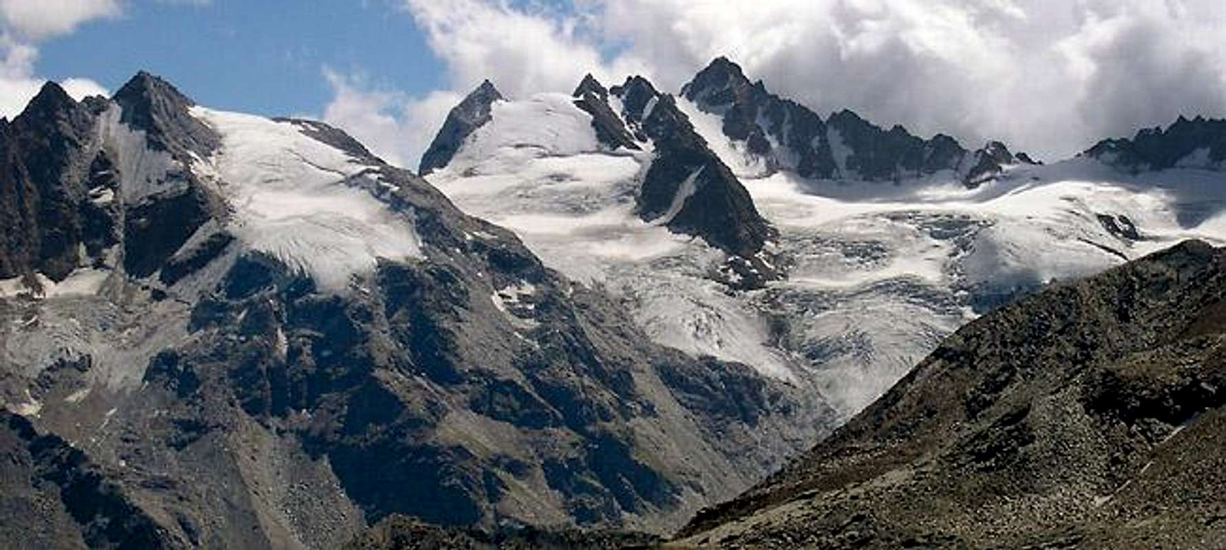
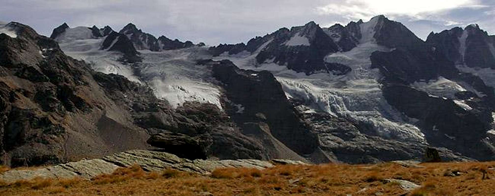
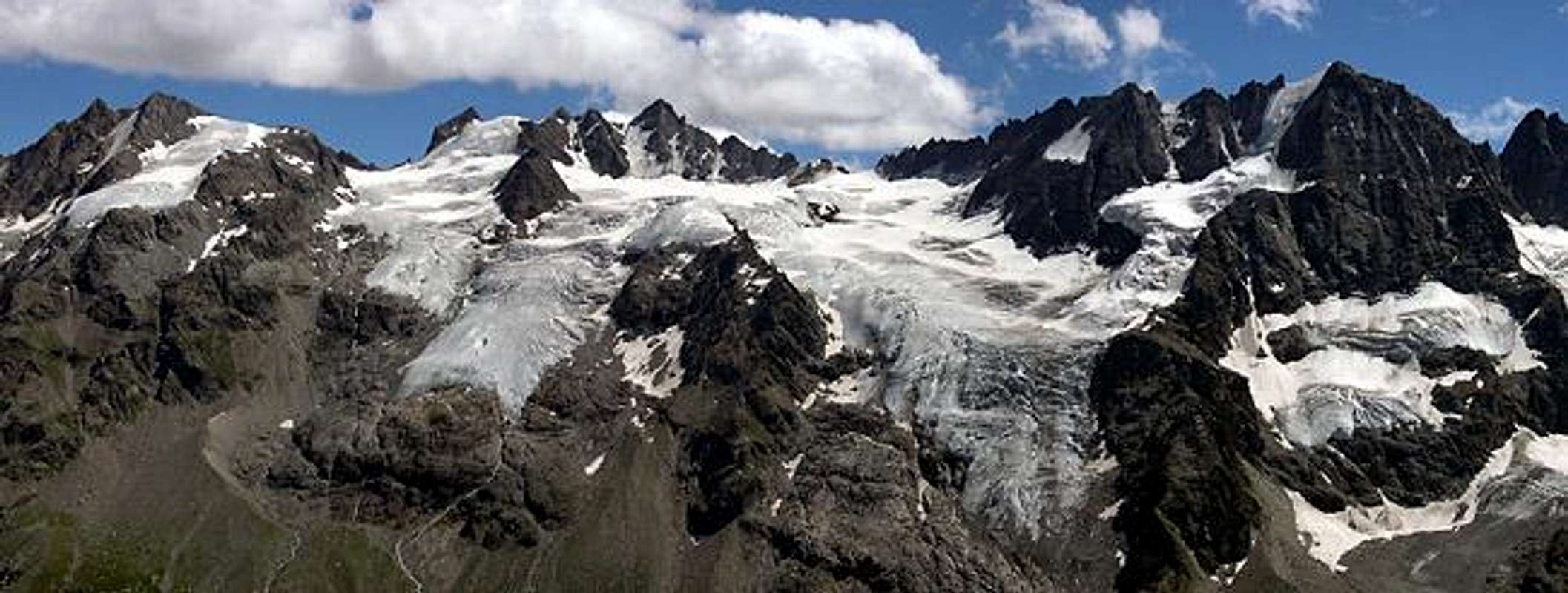
Interactive panoramic views
Move your mouse pointer SLOWLY above the photos to discover the names of both summits and glaciers
"Guida delle Alpi Occidentali" di Giovanni Bobba e Luigi Vaccarone C.A.I. Sezione di Torino Volume II° (parte II) 25-05-1896.
"Guida dei Monti d'Italia-Gran Paradiso Parco Nazionale" E. Andreis, R. Chabod, M. C. Santis, Club Alpino Italiano/Touring Club Italiano, prima Ed. 1939; seconda Ed. 1963; terza Ed. 1980.
"Guida della Regione Autonoma Valle d'Aosta" di Mario Aldrovandi, Ed. S.P.E. di Carlo Fanton Torino 1964.
"Rifugi e bivacchi in Valle d'Aosta" di Cosimo Zappelli aggiornata da Pietro Giglio. Musumeci Editore, Luglio 2002.
"Il Parco Nazionale del Gran Paradiso (Valli di Champorcher-Clavalitè-Saint Marcel-Laures-Cogne-Valsavarenche-Conca di Pila" di Giulio Berutto 3/volume 2°, IGC, Torino 1981, 2a Ed. 2000.
A. Gegenfurtner, G. Klotz, F. Müller "Gran Paradiso", Ed. Bergverlag Rudolf Rother, Monaco 1980 (in tedesco).
G. Klotz "Gran Paradiso" Ed. Bergverlag GmbH Rother, Monaco 2005 (in tedesco).
"Gran Paradiso" di Pierandrea Mantovani e Renato Misischi, Ed. Rassegna Alpina 1974.
"Gran Paradiso - Itinerari Alpinistici e sci Alpinistici" di Franco Brevini Ed. Musumeci, Giugno 1982.
"Diari Alpinistici" di Osvaldo Cardellina e Indice Generale accompagnato da Schedario Relazioni Ascensioni 1964-2019 (inediti).
MAPS:
Kompass - "Gran Paradiso Valle d'Aosta Sentieri e Rifugi" Carta Turistica 1:50000.
Enrico Editore Ivrea-Aosta – "Gruppo del Gran Paradiso" 1:50000.
I.G.C. Istituto Geografico Centrale Torino "Gran Paradiso-La Grivola-Cogne" 1:25.000.
A.I.A.T. "Cogne Gran Paradiso Aymavilles - Walking Map" 1:25.000.
I.G.C. Istituto Geografico Centrale Torino "Il Parco Nazionale del Gran Paradiso" (3) 1:50.000.
L'Escursionista "Valle di Cogne Carta dei Sentieri" (n°10) 1:25.000.
L'Escursionista "Tour de la Vallée de Cogne Grand Paradis" Carta dei sentieri 1:25.000.
A.I.NE.VA. (Associazione Interregionale Neve e Valanghe).
A.IA.T. Cogne Gran Paradis via Bourgeois n° 34 Tel. 0165-74040. E-mail: aiat@cogne.org
Ezio Sport articoli sportivi - via Bourgeois n° 64 Tel. 0165-74204.
Useful numbers
Soccorso Alpino Cogne (SAR) Tel. 3482685406.
Protezione Civile Valdostana località Aeroporto n° 7/A Saint Christophe (Ao) Tel. 0165-238222.
Bollettino Meteo (weather info) Tel. 0165-44113.
Unità Operativa di Soccorso Sanitario Tel. 118.
Acknowledgements
Many thanks are due to the friends of the Italian Team who gave me the essential help for the translation from Italian into English and "Osva" for the new translation in Italian.
Parents refers to a larger category under which an object falls. For example, theAconcagua mountain page has the 'Aconcagua Group' and the 'Seven Summits' asparents and is a parent itself to many routes, photos, and Trip Reports.

 25886 Hits
 97.28% Score
 67 Votes