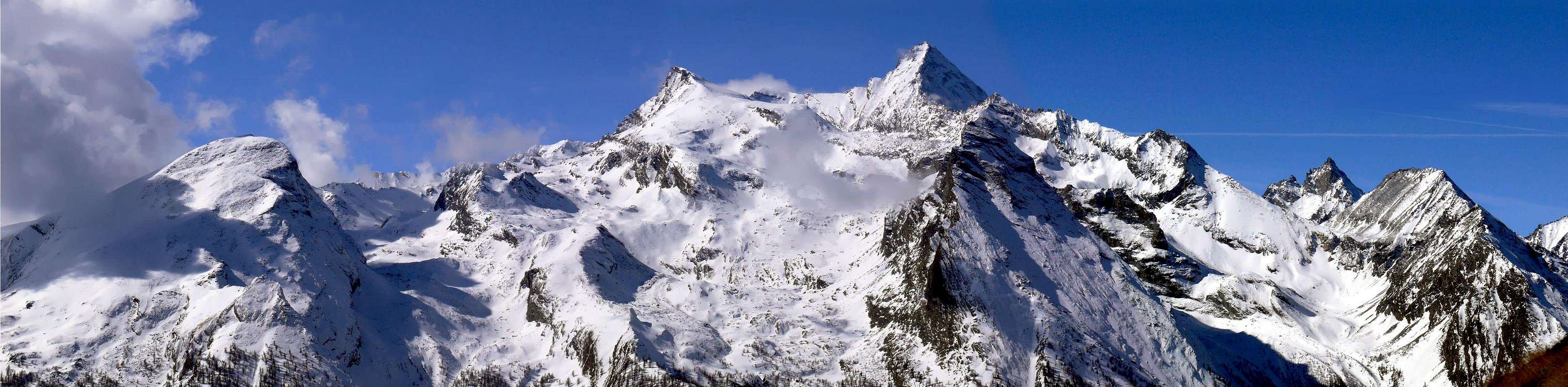
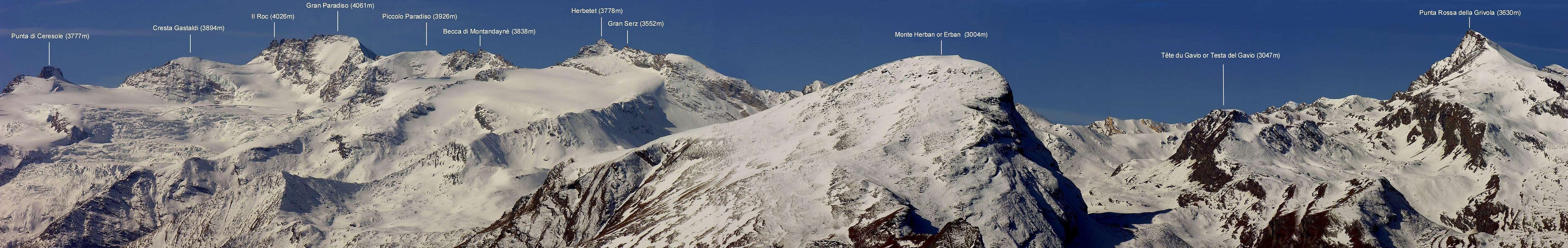
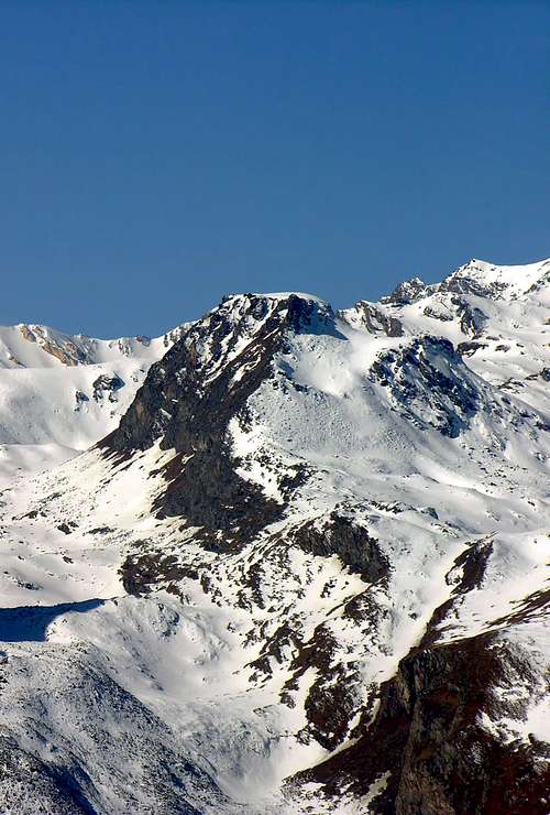
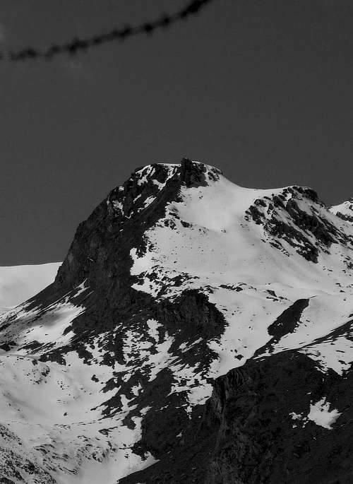
Above the Fractions of Epinel and Crétaz there are two parallel and adjacent valleys, or and better small valley, that meet higher up to the Colle della Rossa (3.190m) between the homonymous peak (3.630m) and the Cote du Loson (3.094m). Amid "stands" the hemiunknown Tête du Gavio (3.047m), both in plain view from the valley floor as poorly known and "courted" by mountain climbers and hikers. From this unknown and abandoned Summit is "birth" a barely mentioned median spur dividing the actual Vallon of Pousset (further West) from a secondary sector called Pian Vario or Plan Varioz below the Mount Herban until to reach the Colle della Rossa (3.190m) just under the homonym point (3.630m). The other two are from Punta Rossa, highest Vertex in this valley, this vallon contain respectively reaching the Punta Pousset towards the North and Mont-de-l'Ouille, with Vermiana Dèsott Pastures (2.093m) towards the Northeast, immediately above the Hamlet of Crétaz. Good eye shots on the Punta Rossa, on the Pousset and, beyond the watershed to the west, on the nearby Grivola (3.969m).
Sopra le Frazioni di Epinel e Crétaz si elevano due valloni o, e meglio, valloncelli, paralleli ed adiacenti che si riuniscono più in alto raggiungendo il Colle della Rossa (3.190 m), posto tra l'omonima punta (3.630 m) e la Cote du Loson (3.094 m). In mezzo "troneggia" la semisconosciuta Testa del Gavio (3.047 m), tanto bene in vista dal fondovalle quanto scarsamente conosciuta e "corteggiata" da alpinisti ed escursionisti. Da questa incognita ed abbandonata Sommità viene "partorito" un appena accennato contrafforte mediano che divide il vero e proprio Vallone del Pousset (più ad Ovest) da un settore secondario denominato Pian Vario o Plan Varioz sottostante al Monte Herban insino a raggiungere il Colle della Rossa (3.190 m) al di sotto dell'omonima punta. Gli altri due che provengono dalla Punta Rossa, Vertice massimo di questo vallone, lo contengono rispettivamente raggiungendo la Punta Pousset verso Nord ed il Mont-de-l'Ouille, nonché l'Alpe Vermiana Dèsott (2.093 m) in direzione Nordest al di sopra della sottostante Frazione di Crétaz. Ottime visuali sulla Punta Rossa, sul Pousset ed, al di là dello spartiacque verso Occidente, sulla vicina Grivola (3.969 m).
First Ascent
First ascent (in the summit): Unknown.
Northeast Face (from Varioz Vallon): Osvaldo Cardellina and Marco Cossard, Aug 21th, 1973.
Western Slope (from Pousset Vallon): Osvaldo Cardellina and Emilio Bertona, Oct 08th, 1998.
Northeast Slope and N-NE Crest (from Epinel): Osvaldo Cardellina and Simonetta B., Jul 12th, 1995.
North-northeast Ridge (Integral from Crétaz through Pousset Valley): Osvaldo Cardellina and Emilio Bertona, Sep. 09th, 1999.
In winter: Unknown.
Getting There
BY CAR:
From Torino, Milano, etc: Motorway A5. Exit at Aosta Ovest. Drive to the near Aymavilles. Follow the directions for Valle di Cogne.
From Switzerland: through the Grand Saint Bernard Tunnel or the namesake Pass. Drive to Aosta, then follow the direction for Courmayeur on SS.26. Just after Sarre, turn to the left, in the direction of Valle di Cogne.
From France: through Mont Blanc Tunnel or Petit St. Bernard Pass. It isn't necessary to take Motorway A5: you can drive on SS.26, in the direction of Aosta. Before arriving at the Village of Sarre, turn right following the sign for Valle di Cogne.After Aymavilles, the SR.47 crosses the Villages of Vieyes, Epinel and Cretaz and after about 25 Km arrives at Cogne (1.534m).
BY PLANE:
Aeroporto "Corrado Gex" Saint Christophe (Aosta).
Approaches
A) - From the small built up area of Crétaz (1.499m), cross the two bridges over the Gran Eyvia Stream and on the Valnontey Torrent. On along the path in the wood and, after passing the various signs of the Parco Nazionale del Gran Paradiso border, walk slightly to the right up to the Alpeggio di Les Ors (1.944m). Follow on the right side up to the big ridge dividing the Valmiana and the Pousset Valleys, once at the Guard Hut down to the middle of the valley, cross a bridge, follow bordering the stream and after crossing again the torrent get out, along a smooth rocky slope, to the near Alpeggio del Pousset Superiore (2.520m).
B) - Or From Epinel Village (1.432m; parking) to descent towards the bridge about 1.400 meters and crossing in Grand Eyvia Torrent; with direction South to take the path n° 27 in Planes Pasture (1.694m) crossroads to change the direction to East-Southeast by path n° 26 trough Great Forest, very fine, fascinating and ancient. By good path, but steep, crossing the Eyfrè Alp (1.950m). Aften one winding road to West, by Southeast direction, leaving to left (East) the path n° 26a toward Fontane wood and Les Ors Pastures to reach Pousset Lower Alp (2.176m; wooden rascards still well preserved and always open with possibility of shelter in case of thunderstorms) near Pousset Torrent. So converges in the previous route nearby the junction 2.303 meters(1h'30) and through this last continues to climb towards the Tête du Gavio.
A) - Dalla piccola Frazione di Crétaz (1.499 m), nel Comune di Cogne, oltrepassare i due ponti uno sulla Grand'Eyvia e uno che scende dal Torrente della Valnontey. Risalire il sentiero che si inoltra nel bosco e, superato i vari cartelli segnalanti i confini del Parco Nazionale del Gran Paradiso proseguire leggermente sulla destra sino a raggiungere l'Alpeggio di Les Ors (1.944 m). Continuare sempre a destra e raggiungere la dorsale che separa i Valloni di Vermiana da quello del Pousset, dove si incontra il Casotto del Guardaparco; proseguire in leggera discesa sino al centro del vallone, attraversare il ponte e continuare a salire costeggiando il torrente. Dopo aver riattraversato il Torrent de Pousset uscire su un dosso di rocce levigate e raggiungere il vicino Alpeggio del Pousset Superiore (2.520 m).
B) - Oppure da Epinel (1.432 m; parcheggio) scendere verso il ponte sul Torrente Grand'Eyvia; con direzione Sud prendere il sentiero n° 27 e al bivio di Planes (1.694 m) cambiare direzione in Est-Sudest con il sentiero n° 26 nel bosco Grand Bois, molto bello, affascinante ed antico. Su splendido sentiero, ma ripido, oltrepassare il canyon formato dalla Côte del Pousset e raggiungere l'Alpe Eyfrè (1.950 m). Dopo un tornante ad Ovest, con direzione Sudest, lasciando a sinistra il sentiero n° 26a, per il Bois de Fontanes e le Alpi Les Ors, raggiungere l'Alpe del Pousset Inferiore o Pousset Dèsot (2.176 m; bellissimi rascards in legno, ancora ben conservati nonché aperti e possibili ad utilizzo di riparo in caso di eventuali temporali), presso il Torrente di Pousset. Raggiungere l'itinerario precedente alla congiunzione dei sentieri a quota 2.303 metri(1h'30).
Route
From the junction of 2.303 meters, do not follow the path n° 26 TVC leading to the Alpe del Pousset Superiore or Dessous (2.520m), but go straight to Mezzogiorno via a large stone with enormous boulders scattered to reach the altitude of around 2.750 meters about at a source that goes down to Plan Varioz; From this point bend gradually until reaching the North-Northeast Crest. Follow the watershed between Pousset/Vario in the last part to reach a rocky tower that, with some steep but exposed passages, can be avoided on the right, (from I° to I°+) leading to the Summit (1h'45/2h'15 from the junction).
VARIANT: Arriving from Crétaz Hamlet (immediately afterwards and toward the East compared to that of Epinel), it is advisable to leave the junction at 2.303 meters on the right (West) by the path n° 25 TVC arriving in a short time Alpe Vermiana (2.382 m); From this continue a little further through the same then leave the same and, tilting right at a dried little brook, reach the North-Northeast Crest at approximately 2.780/2.800 meters. As in the previous itinerary, through this concludes to the Summit (same difficulty and same time). This variant only works if you come from Crétaz.
Dal bivio 2.303 metri non seguire verso Ovest il sentiero n° 26 TVC che conduce all'Alpe del Pousset Superiore o Dessous (2.520 m), ma risalire direttamente verso Mezzogiorno tramite una grande pietraia con enormi massi sparsi fino a raggiungere l'altitudine di 2.750 metri circa presso una sorgente che scende verso il Plan Varioz; da questo punto piegare gradualmente fino a raggiungere la Cresta Nord-nordest. Seguire facilmente lo spartiacque tra i Valloni Pousset/Vario raggiungendo nell'ultima parte una torretta rocciosa che, con qualche passaggio ripido ma esposto, evitabile peraltro abbastanza facilmente sulla destra, (dal I° al I°+) conduce alla Sommità (1h'45/2h'15 dal bivio).
VARIANTE: Arrivando dalla Frazione di Crétaz (immediatamente appresso e verso Oriente rispetto a quella di Epinel), conviene lasciare sulla destra (Ovest) il bivio 2.303 metri raggiungendo con il sentiero n° 25 TVC in breve tempo l'Alpe Vermiana (2.382 m); da questa proseguire ancora un poco tramite il medesimo per poi abbandonare lo stesso e, flettendo a destra presso un ruscelletto essiccato, raggiungere la Cresta Nord-nordest a circa 2.780/2.800 metri. Come nel precedente itinerario, con questa concludere alla Sommità, che, come sopra, conviene aggirare sulla destra salendo (Ovest; con stesse difficoltà e medesimo tempo). Variante conveniente solo se si proviene da Crétaz.
Within the borders of the P.N.G.P. (Parco Nazionale del Gran Paradiso), at the moment (summer 2004), dogs generally are not allowed, except on a couple of trails, and camping is forbidden (except for climbers from sunset till dawn). No fees are due.
Books and Maps
BOOKS:
"Diari Alpinistici" di Osvaldo Cardellina e Indice Generale accompagnato da Schedario Relazioni Ascensioni 1964-2019 (inediti).
"Guida delle Alpi Occidentali", di Giovanni Bobba e Luigi Vaccarone C.A.I. Sezione di Torino Volume II (parte II), 25 Maggio 1896.
"Rifugi e bivacchi in Valle d'Aosta", di Cosimo Zappelli aggiornata da Pietro Giglio, Musumeci Editore, Luglio 2002.
MAPS:
Kompass "Gran Paradiso Valle d'Aosta Sentieri e Rifugi" Carta Turistica 1:50.000.
Enrico Editore Ivrea-Aosta "Gruppo del Gran Paradiso" 1:50.000.
L'Escursionista "Valle di Cogne Carta dei Sentieri" 1:25.000.
L'Escursionista "Tour de la Vallée de Cogne Grand Paradis" 1:25.000.
I.G.C. Istituto Geografico Centrale "Parco Nazionale del Gran Paradiso" 1:50.000.
Parents refers to a larger category under which an object falls. For example, theAconcagua mountain page has the 'Aconcagua Group' and the 'Seven Summits' asparents and is a parent itself to many routes, photos, and Trip Reports.

 1676 Hits
 84.27% Score
 18 Votes