
-
 3865 Hits
-
 81.84% Score
-
 14 Votes
|
|
Mountain/Rock |
|---|---|
|
|
45.47023°N / 7.22212°E |
|
|
10502 ft / 3201 m |
|
|
Overview
This small hilltop is located at the end of the Valley of Seiva or Seyvaz and the end node of the Valsavarenche, where the Southern Buttress of Gran Paradiso, after forming the Becca Moncorvé, the Tresenta, the Ciarforon, Becca di Monciair and Denti del Broglio, goes to "bond" with which to buttress secondary Mer Pertchaz / Punta Fourà drops to the North until you reach the Cima de la Roley or Arollay at the beginning of the Plan of Nivolé. But the "welding" between these two ridges is via a ridge that pseudo straight from the Hill of Eastern Grand Etret (3.152m) reaches the Western (3.172m), after having climbed the little Summit of the same name (3.201m); this fairly large area is covered by the Glacier du Grand Etret, which opens like a fan from the 2.750 meters where a small side trail ends following the numbered coming from Pont Valsavarenche. Turns out to be more suitable for the excursion Ski-Mountaineering, where he met a good attendance, not for Climbing, even though his Eastern Colle is obligatory point of passage for ascents to nearby Teeth of Broglio (3.454m, 3.420 meters about, 3.390m), for other very rare. Its Slope South is rather rocky and falls towards Ceresole Reale into the Canavese (Piedmont), while the Eastern Pass overlooks the small Vallone del Roc with the Bivouac Giraudo; the two are connected by the Porta Hill (3.003m). The views, as well as on Valsavarenche and the Gran Paradiso Chain view from South, ranging in the Southwest at about three Levanne (3.593m, 3.619m, 3.555m), now the border of the Vanoise National Park in France.
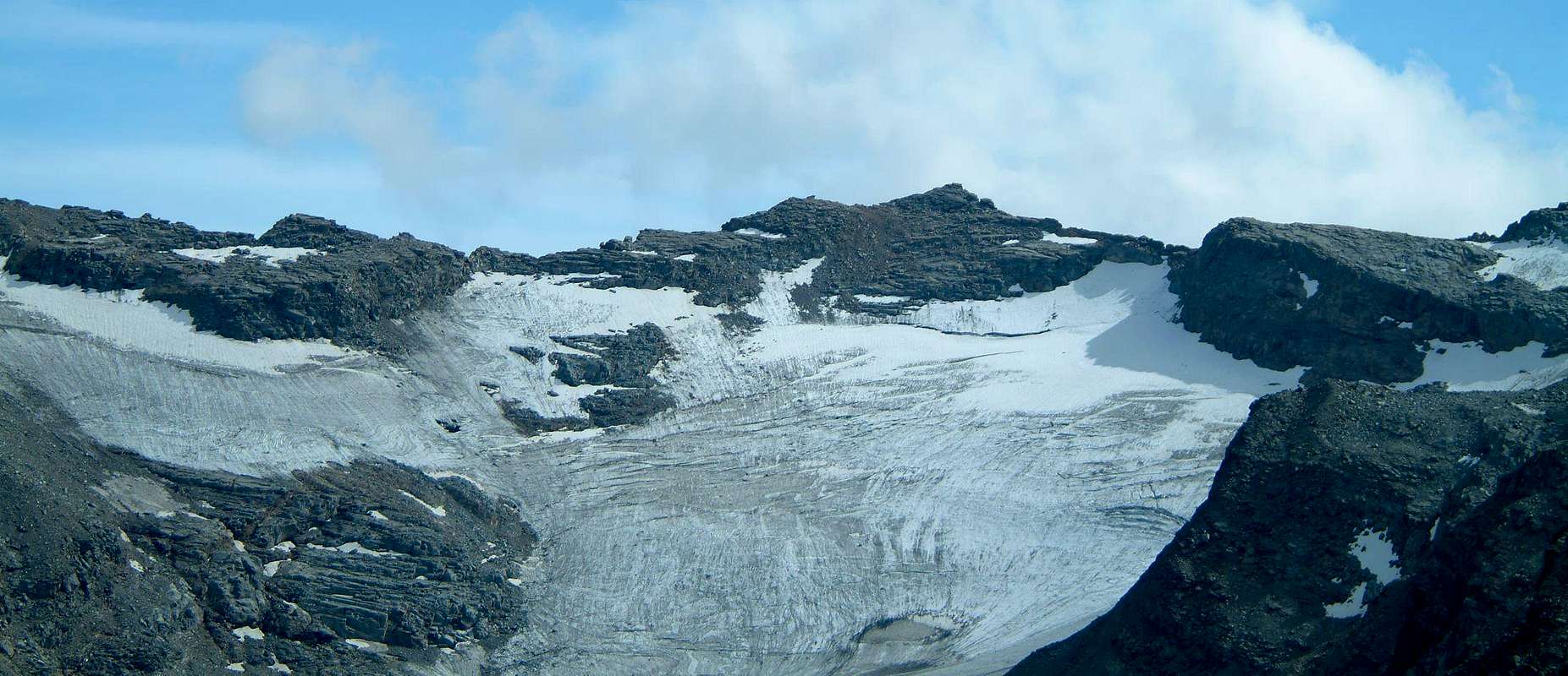
Questa piccola Sommità si trova collocata al termine del Vallone della Seiva o Seyvaz ed al nodo estremo della Valsavarenche, dove la Costiera Meridionale del Gran Paradiso, dopo avere formato la Becca di Moncorvé, La Tresenta, il Ciarforon, la Becca di Monciair ed i Denti del Broglio, va a "legarsi" con il contrafforte secondario che da Mare Pertchaz/Punta Fourà scende a Settentrione fino a raggiungere la Cima de la Roley od Arollay, all'inizio del Piano del Nivolé. Ma la "saldatura" tra queste due creste avviene tramite una cresta pseudo rettilinea che dal Colle Orientale del Grand Etret (3.152 m) raggiunge quello Occidentale (3.172 m), dopo avere scavalcato l'omonima minuscola Sommità (3.201 m); questo abbastanza largo settore è ricoperto dal Glacier du Grand Etret, che si apre a guisa di ventaglio a partire dai 2.750 metri circa laddove termina un sentierino secondario successivo a quello numerato proveniente dai pressi di Pont di Valsavarenche. Risulta essere escursione più adatta per lo Sci-Alpinismo, dove conosce una buona frequentazione, che non per l'Alpinismo, anche se il suo Colle Orientale costituisce punto di passaggio obbligato per le ascensioni ai vicini Denti del Broglio (Meridionale 3.454 m, Centrale 3.420 metri circa e Settentrionale 3.390 m), per altro assai rare. Il suo Versante Meridionale invece è roccioso e scende in direzione di Ceresole Reale in Canavese (Piemonte), mentre dal Colle Orientale sovrasta il piccolo Vallone del Roc con il Bivacco Giraudo; i due sono collegati dal Colle della Porta (3.003 m). Le vedute, oltre che sulla Valsavarenche e la Catena del Gran Paradiso vista rifilata da Mezzogiorno, spaziano a Sudovest verso le tre scintillanti Levanne (Occidentale 3.593 m, Centrale 3.619 m ed Orientale 3.555 m), ormai al confine con il Parco Nazionale della Vanoise in Francia, gemellato con il Parco Nazionale del Gran Paradiso.
First Ascents
- First on the Summit: Unknown.
- In winter: Unknown.
- First traverse (Valsavaranche/Ceresole Valley): J.H. Backhouse, D.V. Freshfield, C. Tucker, T.H. Carson with Mountain Guides Daniel Ballay and Michel Payot, (Jul 20th, 1867).
Getting There
BY CAR:- From France: through the Mont Blanc Tunnel or the Col du Petit Saint Bernard: you can drive on SS.26, following directions for Aosta and, before arriving in Villeneuve, turn right towards Introd. Alternatively, you can take Motorway A5 (at Courmayeur or Morgex) and exit at Aosta Ovest.
- From all the other directions: get to the Aosta Ovest exit of Motorway A5. Then drive on SS.26 Aosta, in the direction of Courmayeur; just after Villeneuve turn left towards Introd.
- Aeroporto "Corrado Gex" Saint Christophe (Aosta).
Approach and Route


Da Pont di Valsavarenche (1.964 m), parcheggio presso il "Camping Pont-Breuil", seguire sulla destra il sentiero n° 2, che costeggia sul lato Ovest il Torrente Savara e percorrere tutto il Vallone di Seiva, oppure de la Seyvaz, passando dall'omonima alpe (2.176 m), conosciuta anche per Alpe di Grand Etret. Proseguire con lo stesso, dopo avere lasciato sulla destra (Sudovest) il sentiero n° 2A per l'Alpe La Seyvaz ed il Col Collet (2.832 m) fino a quando scompare a quota 2.413 metri nella morena sottostante il Glacier du Grand Etret. Tramite una piccola traccia, che termina in altitudine 2.750 metri circa, e in diagonale Ovest/Est per il ghiacciaio (sempre più in fase di evidente ritiro in quest'ultimo trentennio) risalire al Colle Orientale del Grand Etret (3.150 m; 3h'30). Dallo stesso seguendo lo spartiacque verso Occidente e tramite la facile Cresta Nordest in breve tempo si raggiunge la triangolare e piccola Vetta (EE/A/F+; 0h'20; 4h'00).
Difficulty
From F to F+.Da Sci-Alpinismo.
Red Tape
Within the borders of the P.N.G.P. (Parco Nazionale del Gran Paradiso), at the moment dogs generally are not allowed, except on a couple of trails, and camping is forbidden (except for climbers from sunset till dawn). No fees are due.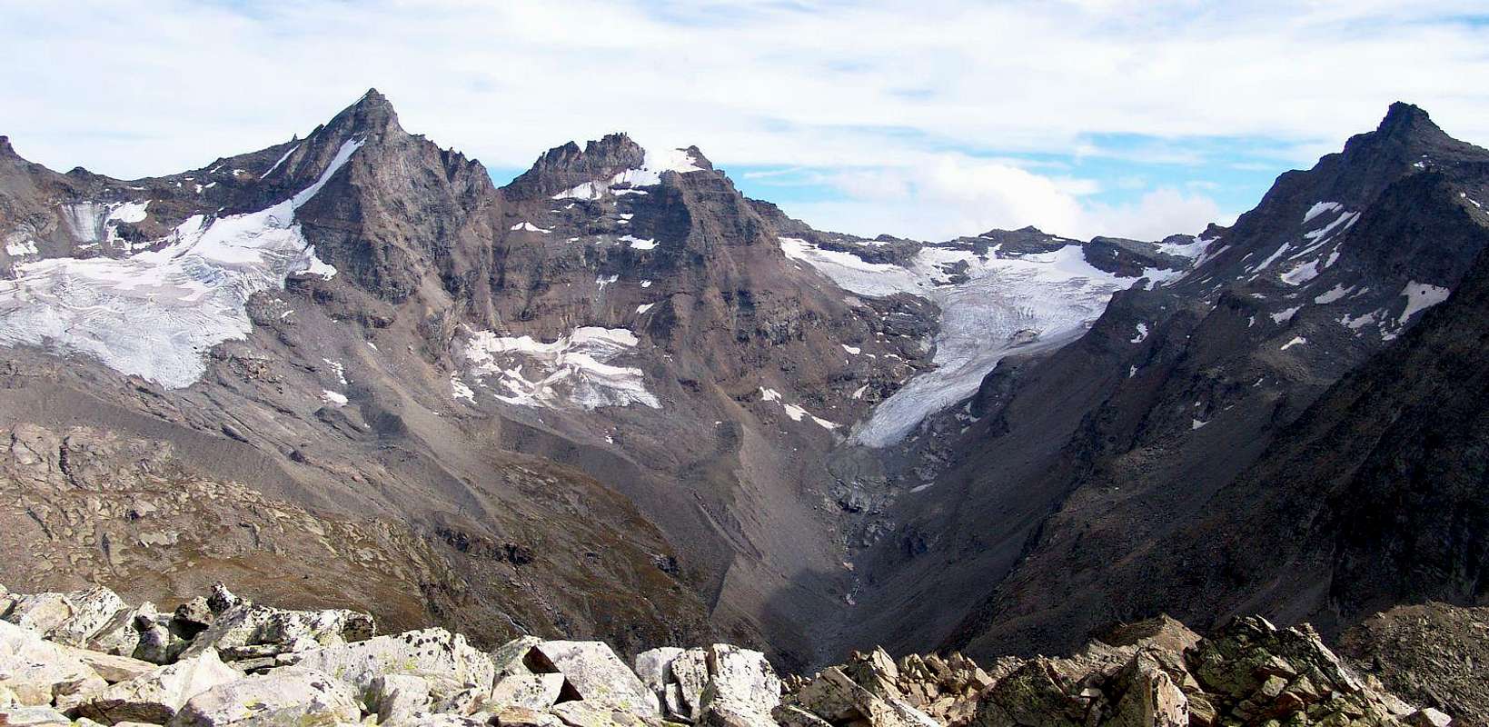
Campings
- Wild camping in the Parco Nazionale del Gran Paradiso is strictly forbidden!!!
Mountain Condition
- You can get meteo information at the official site of the Regione Valle d'Aosta:
- Valle d'Aosta Meteo
Webcam
- WEBCAM on Aosta Valley:
- Webcam
Books and Maps
BOOKS:- "Parco Nazionale del Gran Paradiso" di Stefano Ardito, Ed. Guide iter, Novembre 2001.
- "Guida delle Alpi Occidentali", di Giovanni Bobba e Luigi Vaccarone C.A.I. Sezione di Torino Volume II (parte II), 25 Maggio 1896.
- "Gran Paradiso", A. Gegenfurtner, G. Klotz, F. Müller, Ed. Bergverlag Rudolf Rother, Monaco 1980 (in tedesco).
- "Gran Paradiso", G. Klotz, Ed. Bergverlag GmbH Rother, Monaco 2005 (in tedesco).
- "Diari Alpinistici" di Osvaldo Cardellina e Indice Generale accompagnato da Schedario Relazioni Ascensioni 1964-2019 (inediti).
- "Guida della Regione Autonoma Valle d'Aosta" di Mario Aldrovandi,Ed. S.P.E. di Carlo Fanton, Torino 31 Dicembre 1964.
- "Guida dei Monti d'Italia-Gran Paradiso Parco Nazionale" E. Andreis, R. Chabod, M. C. Santis, Club Alpino Italiano/Touring Club Italiano, prima Ed. 1939; seconda Ed. 1963; terza Ed. 1980.
 |
 |
 |
 |
MAPS:
- Kompass "Gran Paradiso Valle d'Aosta Sentieri e Rifugi" Carta Turistica 1:50.000.
- L'Escursionista "Valsavarenche Gran Paradiso Carta dei Sentieri" (n° 9) 1:25.000.
- Meridiani Montagne "Gran Paradiso" 1:25.000.
- Enrico Editore Ivrea-Aosta "Gruppo del Gran Paradiso" 1:50.000.
- L'Escursionista "Valle di Cogne Carta dei Sentieri" 1:25.000.
- L'Escursionista "Tour de la Vallée de Cogne Grand Paradis" 1:25.000.
- I.G.C. Istituto Geografico Centrale "Parco Nazionale del Gran Paradiso" 1:50.000.
- Studio F.M.B. "Gran Paradiso" Bologna 1:50.000.
- I.G.C. Istituto Geografico Centrale Torino "Valsavarenche Val di Rhêmes Valgrisenche P.N.G.P.", 1:25.000.
Important Information
- REGIONE AUTONOMA VALLE D'AOSTA the official site.
- FONDAZIONE MONTAGNA SICURA Villa Cameron, località Villard de la Palud n° 1 Courmayeur (AO) Tel: 39 0165 897602 - Fax: 39 0165 897647.
- SOCIETA' GUIDE ALPINE DEL GRAN PARADISO Comune di Valsavarenche.
- A.I.NE.VA. (Associazione Interregionale Neve e Valanghe).
Useful Numbers
- Protezione Civile Valdostana località Aeroporto n° 7/A Saint Christophe (Ao) Tel. 0165-238222.
- Bollettino Meteo (weather info) Tel. 0165-44113.
- Unità Operativa di Soccorso Sanitario (Emergency Medical Assistance). Phone: 118.