
-
 3093 Hits
-
 77.48% Score
-
 8 Votes
|
|
Mountain/Rock |
|---|---|
|
|
50.76622°N / 115.03576°W |
|
|
Scrambling |
|
|
Spring, Summer, Fall |
|
|
8743 ft / 2665 m |
|
|
Overview
“Little Evan” is a minor summit the central area of the Opal Range with a summit elevation of 2665 metres (8,743 ft.). This lesser peak does not have an official name, and based on its relatively remote location in the Front Ranges, it is infrequently ascended. The low height of this peak, along with the somewhat high treed shoulders, makes this peak hard to discern from the surrounding valleys. In fact, the official government topographic map does not show a tree line on this peak, but a tree line does exist. Considering all aspects, the average elevation of tree line is 2400 metres, exposing an alpine zone of about 265 metres. The neighbouring peak is a major summit in the Opal Range; “Ripsaw” (GR 373253) at 3008 metres (9,868 ft) is the fourth highest mountain in the range. “Little Evan” has a prominence of 185 metres from the col shared with ‘Ripsaw’. GR denotes grid reference of the Universal Transverse Mercator (UTM) National Topographic System of Canada (NTS).The contrived name of “Little Evan” is a combination of the partial names of the surrounding creeks and rivers that drain from this summit and the nearby pass, Evan-Thomas Pass. These two watercourses, Evan-Thomas Creek and Little Elbow River, are two of the more major drainages within the Opal Range. This peak, along with ‘Ripsaw’, split the Little Elbow River into a North and West Branch, a south branch heads to Tombstone Pass. The treed Evan-Thomas Pass is about 2.5 kilometres north of this summit. This little peak is nestled between these drainages and thus I derived the name Little Evan.
There is no published route information for this peak, nor any mention of this summit in the local backcountry hiking guidebooks. The adjacent valleys are well used by equestrian recreationalists, and hunters in the fall, but less so by hikers since this peak is fairly far from any parking area. There is no record of the first ascent, but we did find a collapsed cairn on the summit that did not contain a summit register.
Getting There
 |
‘Little Evan’ is one of the few Opal Range peaks where access is better from the east and not the regular approach via Highway 40 along the western edge of the range. Similar to Highway 40, parts of Highway 66 are closed for wildlife protection from December 1 to May 15 each winter/spring. Best vehicle access from Canmore/Banff or Calgary is via the Trans Canada Highway, then south on Highway 22, through the hamlet of Bragg Creek, south to the intersection of Highway 22 and 66. Head west on Highway 66 to its end at Little Elbow Provincial Recreation Area, about 33 kilometres from Bragg Creek. Note that Highway 66 is closed December 1 to May 15 at Elbow Falls, approximately 22 kilometres from Bragg Creek. |
|---|
Even though there is ample space, and a nearby parking lot, for some unknown reason no trailhead parking is allowed at the start of the Little Elbow trail, with trailhead parking approximately 2 kilometres to the east, near the entrance of the recreation area. There is good directional signage to the parking area. Hike, or the recommended method, bike, 2 kilometres along the campground roadway to the start of the Little Elbow trail (50.788973, -114.872217). The start of the hike/scramble up ‘Little Evan’ is approximately 16 kilometres from the start of the trail (18 km from the parking lot), with much of this trail in very bikeable condition. A mountain bike for the approach is highly recommended.
Red Tape/Camping and Bivouacs
The parking area to access ‘Little Evan’ is located in the Little Elbow Recreation Area. No permit or fee is required to park in this provincial area. The ascent of ‘Little Evan’ involves a long approach, likely not completed without a bike approach, if walking, or seeking a shorter day, an overnight trip would be required. The Mount Romulus backcountry campground provides an excellent base for a scramble of ‘Little Evan’. The ‘Little Evan’ peak and the Mt. Romulus campground are located in the Elbow-Sheep Wildland Provincial Park.
Backcountry camping permits are required at all designated backcountry campgrounds anywhere in Kananaskis Country. Random backcountry camping without a permit is allowed in most Wildland Provincial Parks, including Elbow-Sheep Wildland Provincial Park. Permits can be purchased in person at the Elbow Valley Visitor Information Centre and the Barrier Lake Visitor Information Centre during normal hours of operation.
When to Climb
Typical Canadian Rockies situation with July and August providing the best conditions for alpine scrambling. Little Evan’s position in the dry front ranges extends the summer season and is usually dry from May to late October.
Approach
 |  |
| A mountain bike is highly recommended for this approach. From the Little Elbow trailhead (not accessible by motor vehicle from December 1 to May 15) take the wide double track trail (former road) to the Mount Romulus backcountry campground turnoff. This turn off is very obvious and has a directional sign. This turn is 11.5 kilometres from the start of the trail. | The Little Elbow River splits and takes a hard south turn near the Mt. Romulus backcountry campground, the other river branch heads west and soon (about 1 km from the campground) splits into a west and north branch. |
|---|
From the main Little Elbow trail, the connector trail to the campground is about 500 metres, heading north east from the turnoff. Once at the campground, ford the south branch of the Little Elbow, a good and obvious trail heads west from the campground. This trail soon climbs a short steep hill, but easily bikeable. Continue on this good trail for about 4 km to gain a view of the col between ‘Ripsaw’ and ‘Little Evan’ (50.751072, -115.034466). Park the bike and head for the open scree/meadows below the col. A short ford of the West Branch of the Little Elbow River, then light bushwhack to open terrain below col, simple hike to col.
Route Description
There is no published information regarding the ascent, approach or view of this little peak.- South-West Ridge, Alpine I, Class 3
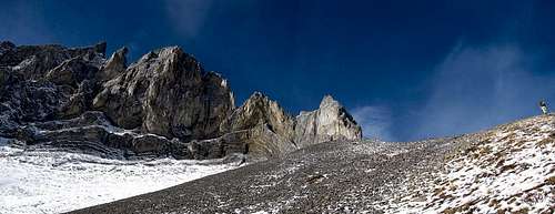 |
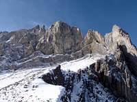
From the ‘Ripsaw’ / ‘Little Evan’ col, hike the south west scree slopes aiming to gain the obvious south west ridge. After about 200 metres of elevation gain, the summit ridge becomes sharper and becomes a solid class 3 scramble with hand holds required on the loose rock along with short sections of exposure to big drop offs. |
|---|
 |
 |
 |
| Approximately 75 metres of an exposed and loose summit ridge reaches the summit. We descended straight south from the summit, but was you descend, the easy scree slopes lead to a tight canyon formation, stay to skier’s right to avoid the canyon drop off. Once near tree line, head south back to the trail. | |
|---|
 |
 |
 |
 |
|---|