
-
 2728 Hits
-
 81.84% Score
-
 14 Votes
|
|
Mountain/Rock |
|---|---|
|
|
50.66106°N / 113.91°W |
|
|
Trad Climbing |
|
|
Summer |
|
|
8793 ft / 2680 m |
|
|
Overview
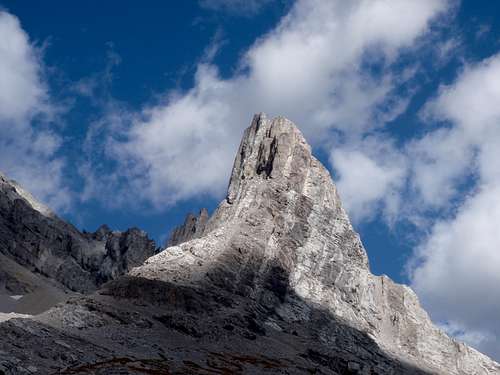
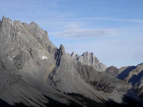
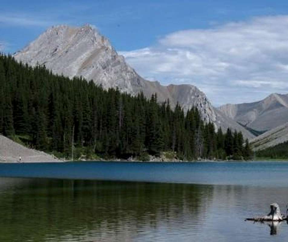
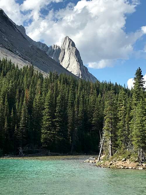
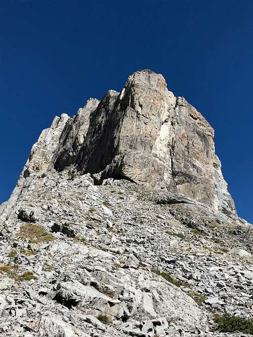
Elpoca Tower is an unofficial, local name applied to a beautiful outlier of the mighty Elpoca Mountain. Elpoca Tower is a prominent high point on a ridge that extends east, south-east from the summit block of Elpoca Mountain, at Grid Reference 401140. The point summit has an elevation of about 2680, with no prominence shown on the topo map, but it does have a small low point col towards the main Elpoca Massif that drops about 75 metres. This attractive feature is very obvious from the busy Elbow Lake area.
|
|
|
Having viewed Elpoca Tower many times over the years, I found out the only documented route was by some local hard core climbers in 1997. Originally I had found an awesome trip report by Orvel Miskiw on bivouac.com which gives interesting backstory and personal views, but no topo map. The recent David Jones guidebook (2020) "Rockies South. The Climber's Guide to the Rocky Mountains of Canada: Volume 1" provides some more detail, but really, the route is obvious since it mostly climbs a narrow ridge.
Getting There
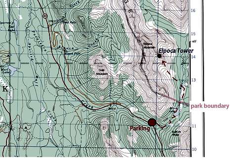
Best vehicle access from Canmore/Banff or Calgary is via the Trans Canada Highway, then south along Highway 40. From the intersection of Highway 40 (Kananaskis Trail) and Highway 1 (Trans Canada Highway) travel south past the Kananaskis Lakes turnoff, then to the Elbow Lake trail head.
Access to the parking area, Elbow Lake trail head, is affected by a seasonal road closure and is not accessible by motor vehicle from December 1 to June 15. Park in the Elbow Lake parking lot, approximately 62 km south of the Trans Canada Highway.
Red Tape / Camping and Bivouacs
Peter Lougheed Provincial Park is a popular and busy recreation area hectic with front country users in the summer months.
Important Red Tape Update. As of June 2021, a mandatory user fee will be in place for Kananaskis Country - $90 for an annual pass or $15 for a day pass.
More information: https://www.alberta.ca/kananaskis-conservation-pass.aspx
The approach for Elpoca Tower is relatively short and typically would not require a bivy. Within Peter Lougheed Provincial Park, backcountry camping, including bivouacs for climbing, are only allowed in designated campsites. Elbow Lake campground is close to Elpoca Tower, so if more time was desired in the area, it provides an excellent base. Overnight permits can be purchased in person at the Barrier Lake or the Peter Lougheed Provincial Park Visitor Information Centres during normal hours of operation.
Elpoca Tower is in the Elbow Sheep Wildland Provincial Park, which does not require camping in campgrounds and allows random camping if a camp is more than 1.0 kilometre from a designated backcountry campsite.
Up to date information about Peter Lougheed Provincial Park and Elbow Sheep Wildland Provincial Park available at:
Peter Lougheed Provincial Park
Elbow Sheep Wildland Provincial Park
Approach
The trail to Elbow Lake is one of the busiest in Peter Lougheed Provincial Park and likely has the highest volume of users of any trail within the Opal Range. The distance to Elbow Lake is short, only 1.0 km to the lake, and provides the only backcountry campground in this part of the park. As well, the scenery is fantastic, the trail, though steep in parts, is well maintained and clearly signed. Also this trail provides access to the southern edge of the popular “Elbow Loop” trail, mostly for mountain bikers, equestrians and hunters in the fall. 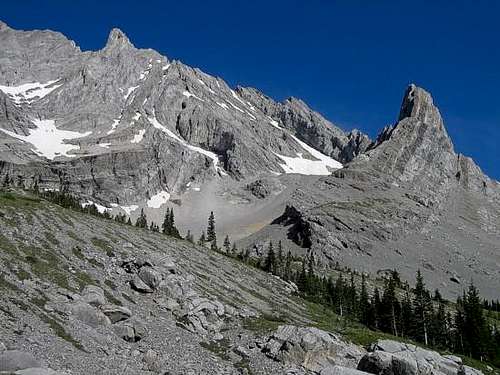
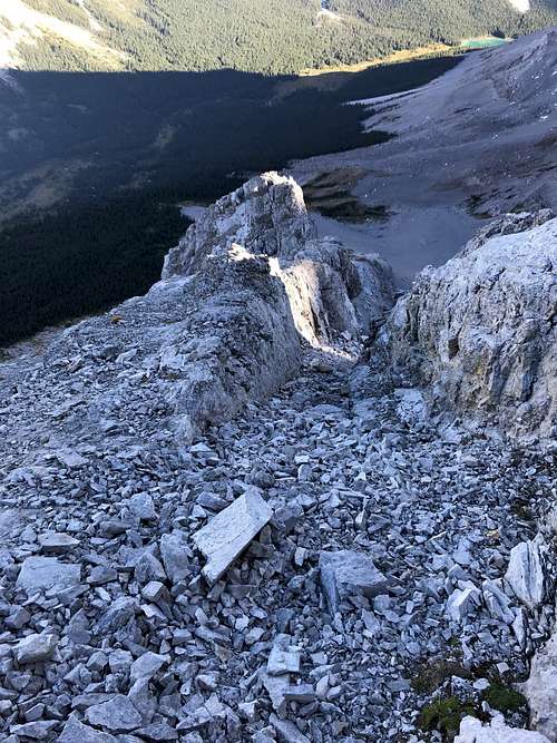
Approach to Elpoca Tower, follow the main trail eastward, past the lake. About one kilometre beyond the lake, a view to the absolutely spectacular Elpoca Tower opens up. Pick your line, all routes viable, light bushwaching required, and a crossing of the Elbow River, but all easy to manage.
When to Climb
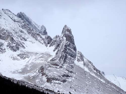
Typical Canadian Rockies situation; best conditions for a high elevation alpine rock route is July to early September. Often the route will hold snow into early July, so August is best month to have dry conditions
Route Description

|

|
We attempted to climb this tower twice, before we decided to try a new line. Our first attempt was in August 2019, and again on August 21, 2020. Both times, the same thing happen, great weather forecast, but the weather turned on us as we roped up. On the August 2020 attempt, I was leading the lower section of the Miskiw/Morrissette/van Ness route, rated at 5.8, trad protection, the wind and temperature were horrible, ice cold wind, temperature around zero, tons of exposure down the north side of the tower, and not the best rock quality, after nearly being blown off the ridge, we bailed. We both agreed that our next attempt would be something different. We used our time to explore a nice big ledge that continued along the slabby south face.
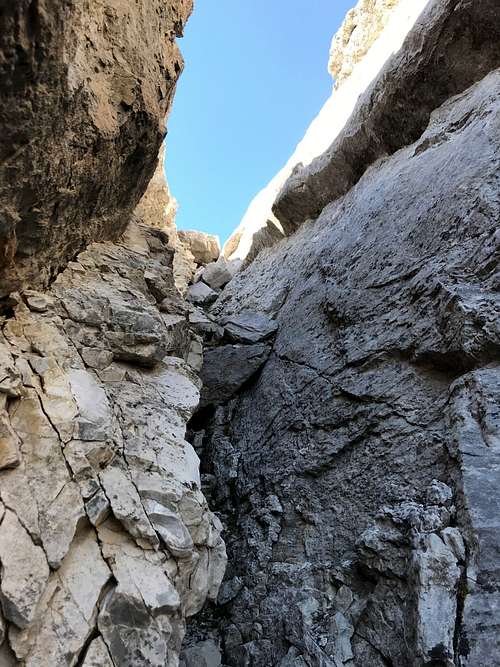
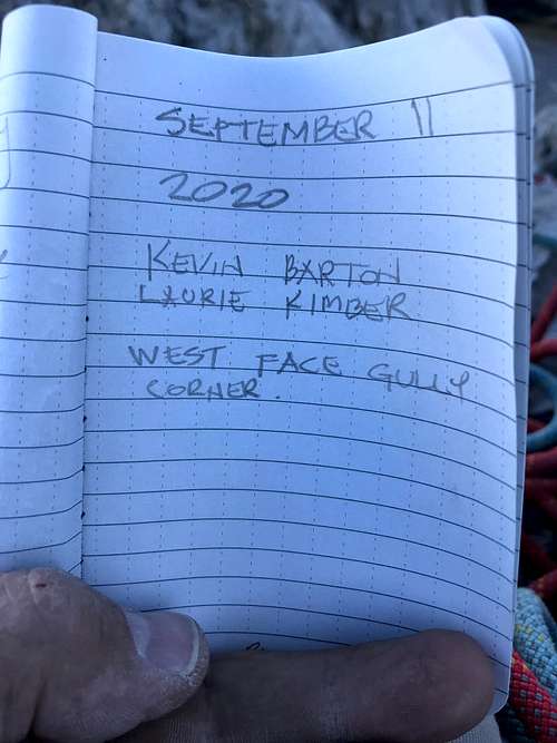
This ledge was key for our future plans; from the base of the standard route, the ledge narrows and is exposed to the big south face and is covered with rubble. Care is needed, but nothing too crazy. Nearing the end of the ledge, a small notch is encountered, climb over this little bump via a narrow gap to a small scree ledge. Above this scree pad there is a deep notch running behind a huge slab on the south face. We made a few forays up different sections of the face above the ledge and decided to return as soon as possible. Turns out we were eventually successful on a new line on September 11, 2020. Interesting, checking out the base on the face here, I found an old yellow poly rope, likely an old rappel anchor.

|

|

|
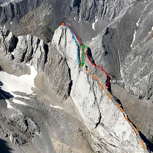
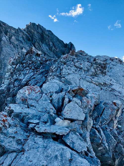
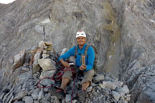
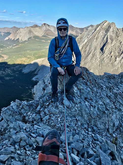
September 11, 2020, approached via Elbow Lake trail, up the south ridge of Elpoca Tower, passed the standard route, traversed the ledge over the bump to small scree ledge. I attempted to lead a 5.8 wall, just below the bump, but the rock quality was poor and protection hard to get. I had to convince Laurie it wasn't too late to try the tight gully behind the huge flake. We turned our attention to this line.
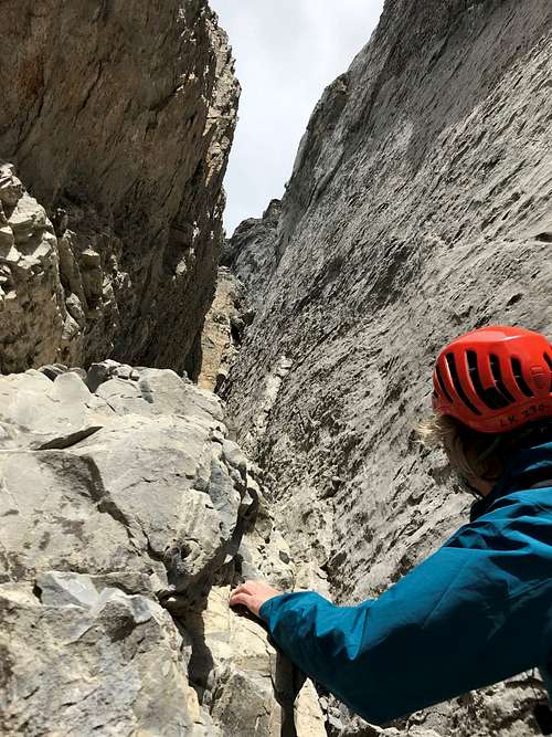
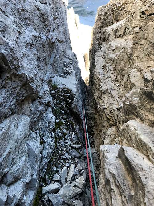
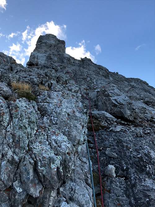
There was a tight chimney behind the huge flake/slab of the South Face. The lower section of the chimney was a dirty scramble. As you ascend a few difficult steps are encountered. I scrambled up a short 5.7 ish step, but stopped and built a super solid piton station on nice flat spot above this greasy step. Probably about 25 metres of 5th class climbing to this station. From the station there were 3 or 4 steps that were 5.6/5.7 ish, one was a super fun layback with a beautiful solid hand crack. A full rope stretch of 60 metres got me just below a lower scree ramp, couldn't make it there and had to build a station in the narrow chimney. Once out of the chimney, steep scree hike to summit block. Laurie built a piton station at the base of the summit block.
|
|
|
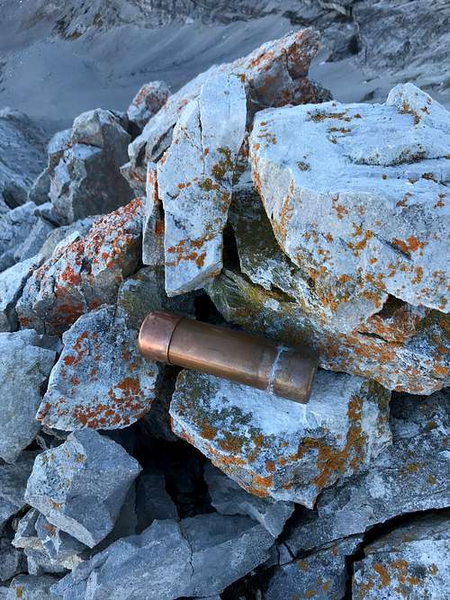
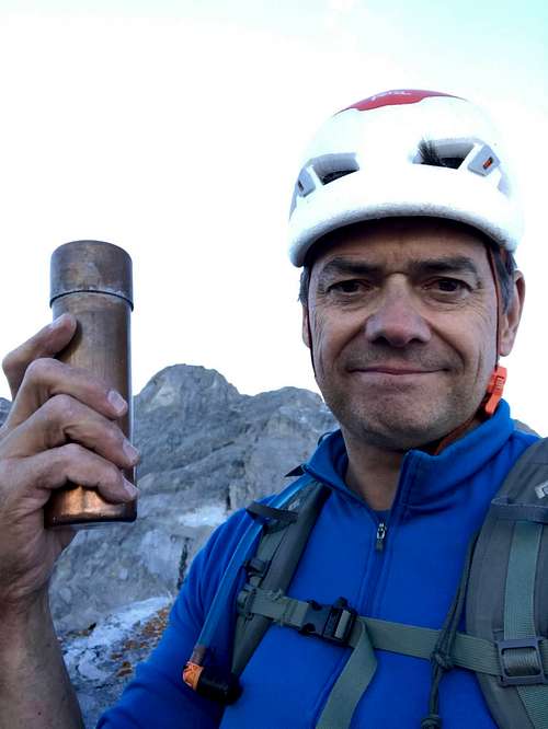
Once at the summit block, my chosen line was an exposed and awkward 5.6 section of about 20 metres, then a flat loose scree walk to the summit cairn. Laurie left the station in place and I looped a summit boulder for a station and brought the big guy up. I was super excited and happy get to this summit. I was very surprised to find a new (July 2020) summit register. I know the Miskiw party climbed this tower in 1997. They had found a summit cairn, but no record. I believe Orvel Miskiw climbed the tower a second time (installed a bolt at the 5.8+ first pitch crux), but I have found no other ascents documented. Two parties climbed this tower in July 2020. Enjoyed the cool perspective of this exposed summit, especially the view to the main massif of Elpoca Mountain. In June 2017, I put a new route on north and west side of Elpoca Mountain and descended the standard route, much of the descent is via the "Golden Gully". We had all snow in the gully, I would recommend climbing this gully with snow.
|
|
|
|
|
|
Descent was mostly straightforward, since it was getting dark, I was hoping to get to easy ground before full darkness. I belayed Laurie off the summit boulder as he downclimbed to the last station. Once on belay, I too downclimbed to the station, once there I went straight down the main ridge crest, descending to skiers left of our ascent line. Once I got to the full 60 metres of rope. I did quickly pull down the route as Laurie neared. We were above where the standard route traverses a ledge below the ridge proper, we could not find any anchors or even see how to access this ledge. I did find an excellent boulder on the top of the ridge, slung it and we rapped. I wasn't fully sure the rope would reach the ledge where we started, but a full 60 metre rope stretch, and we were on the scree ledge by the bump of our lower ledge traverse as full darkness set in. All easy terrain from there back to the parking lot.
External Links
My trip report on Alpine Soft. Chillaxed Alpine Climbing in the Canadian Rockies.