
-
 3468 Hits
-
 78.27% Score
-
 9 Votes
|
|
Mountain/Rock |
|---|---|
|
|
50.79738°N / 115.10754°W |
|
|
Mountaineering, Trad Climbing, Scrambling |
|
|
Summer |
|
|
9564 ft / 2915 m |
|
|
Overview
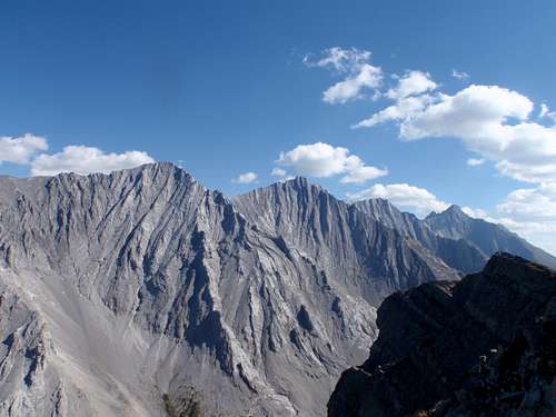
Rocky Peak is a large and looming mountain located near the northern terminus of the Opal Range in Elbow-Sheep Wildland Provincial Park. This peak does not have an official name and, until recently, there was no record, neither written nor shared in pubs, about an ascent of this significant mountain. The sharp summit reaches an elevation of 2915 metres (9,564 feet) and is the sixteenth highest summit in the Opal Range (I have identified 35 significant high points in the range).
I applied the name of “Rocky Peak” to this northern end of the main Opal Range since it is the head waters of Rocky Creek, which is an official watercourse name. This high peak is just south of The Wedge/”MacKay Hills” highpoint, which is the extreme northern end of the Opal Range. The structure, shape and composition of Rocky Peak is strikingly similar to its taller sisters, connected by summit ridges to the south, including the mighty Mt. Evan-Thomas.
 Rocky Peak (l), Mt. Denny, Mt. Potts and Mt. Evan-Thomas (r)
Rocky Peak ends the range to the north, but is connected to the south to ‘Mount Denny’ (GR 338277). The summit of Rocky Peak is about 1 kilometre north of Mt. Denny (3000 m) and shared col between is approximately at 2800 metres; giving Rocky Peak a prominence of 115 metres from the col.

Rocky Peak (l), Mt. Denny (r)
The only recorded ascent of this mountain is by me. My long time office friend (L. Kimber) and I (Kevin Barton) ascended the complex and broken West Face via a steep slab gully, then face climbing to the upper summit ridge, West Ridge, on July 2, 2014. We found no cairn or evidence of previous ascents. I built a cairn on the highpoint (northern tower) and left a makeshift summit register, which will probably be eaten by the numerous summit pikas.
Getting There
Easy highway access from Highway 40 along the western edge of the Opal Range provides the best approach. Highway 40 does provide access from the Trans Canada Highway in the north, and continues south to the Longview area, but the southern section is closed for wildlife protection from December 1 to June 15 each winter/spring. Best vehicle access from Canmore/Banff or Calgary is via the Trans Canada Highway, south along Highway 40.
From the intersection of Highway 40 (Kananaskis Trail) and Highway 1 (Trans Canada Highway) travel south towards Kananaskis Lakes. Depending on approach, either park at the Fortress Junction gas station/store, 41.3 km south of the Trans Canada Highway or at the Grizzly Creek parking area, 44.5 km south of Trans Canada Highway.
Red Tape / Camping and Bivouacs
Elbow-Sheep Wildland Provincial Park is a grand and beautiful park. Once primarily the domain of horseback riders and fall game hunters, this area sees more and more hikers, scrambles and climbers. The approach from the south is through a relatively untraveled valley and quite scenic. The approach trail to the top of Opal Ridge is busy on any weekend.
No permit is required to park or climb in Elbow Sheep Provincial Wildland Park and an ascent of Rocky Peak can be accomplished in a long day so many climbers may chose to bivy in upper Rocky Creek. Random backcountry camping without a permit is allowed in most Wildland Provincial Parks, including Elbow-Sheep Wildland Provincial Park. Up to date information about Elbow-Sheep Wildland Provincial Park available at:
Elbow-Sheep Wildland Provincial Park
Approach
Opal Ridge Approach
<cellspacing="10"> <cellpadding="10">
 West side of Opal Ridge |
|
This is the shortest and most direct approach to Rocky Peak, but does require about 850 metres of elevation up Opal Ridge, then a descend of 300 metres to Rocky Creek, and of course, the same on the return. This direct approach is about 3 kilometres from the parking area to the base of the west slopes of Rocky Peak. From the Fortress Junction gas station/store, park in the northern end of the parking lot, head up the creek, a big trail starts on the lower left (north) side of the creek, the trail is well packed and large, should be easy to find. Follow this trail a short distance up hill to a power line. Turn left, north, follow the power line road for about 400 metres, just after crossing a low stream, a cairn marks the start of the Opal Ridge trail. This trail is a highway, wide and well pack, but does have 2 or 3 rock bands that requires hands scrambling. Reach the ridge crest in about 1.5 hours, descend easy east slopes to west slopes of Rocky Peak. |
|---|
South Approach | Grizzly Creek
<cellspacing="10"> <cellpadding="10">
 East side of Opal Ridge |
|
From the Grizzly Creek parking lot you need to access upper Grizzly Creek, which can be difficult as there is no official trail and significant elevation gain through dense trees. Once in the upper drainage of Grizzly Creek, head north over a slight pass into upper Rocky Creek. This pass is the low col between the southern end of Opal Ridge and GR 339269 (’Mt. Potts’). From the parking lot, this pass is about 750 metres of gain and 3 kilometres. Descend into upper Rocky Creek, pass Mt. Potts and Mt. Denny to reach the west slopes of Rocky Peak in about 3 kilometres. |
|---|
When to Climb
Typical Canadian Rockies situation; best conditions for a high elevation alpine rock or scramble route is July to early September.
Route Description
There are no sources for published route information for Rocky Peak. The below description, and the more detailed route description page, are the only sources for information on this significant peak.
- West Gully/Face, West Ridge, 5.6, Alpine II
The only recorded ascent of Rocky Peak, and the first ascent of the West Face and West Ridge by Kevin Barton (OSWB) and L. Kimber July 2, 2014.
My original goal was to ascend the prominent West Rib on the west side of Rocky Peak, but my partner was concerned about the time required to pitch out this route, and still have time to make the summit. We had a great view of this cool rib as we climbed the easy Class 3 gully beside it. I would guess it mostly goes at 5.6, with the odd harder step, maybe up to 5.7 or 5.8. Looked like a fun route, maybe one day I can return to climb it.
<cellspacing="10"> <cellpadding="10">
 View up west gully View up west gully |
 Nearing summit ridge Nearing summit ridge |
 End of summit ridge End of summit ridge |
|---|
The West Rib is an obvious landmark on the west side of Rocky Peak. We ascended the low angled gully beside it. Mostly an easy scree hike with the odd short slab section. Efficient and fast height gain up gully. Gully ends in a steep wall, we solo’ed from gully to top of West Rib; first on 30 metres of 5.6 slab, then about 40 metres of 5.5 slab to easy scree to top of rib. From top of rib about 150 metres of steep slab, but solid and great holds (Class 4) lead to the summit ridge. Follow summit ridge to summit, mostly 5.2 or 5.3 on loose ridge, if pitching about 5 rope lengths to summit tower.
<cellspacing="10"> <cellpadding="10">
 Virgin summit? Virgin summit? |
 New summit cairn New summit cairn |
 Marked summit Marked summit |
|---|
<cellspacing="10"> <cellpadding="10">
 Laurie on south tower Laurie on south tower |
 New summit register New summit register |
 Selfie from south tower Selfie from south tower |
|---|
Our descend was down steep scree and slab sections of the South/South West Face. We did run into a steep section that we downclimbed. This section was about 70 metres of steep 5.7/5.8 that was difficult to protect. We did leave 3 pitons (2 pin anchor at the top), 1 piton about 15 metres below the 2 piton anchor. Left pitons since my partner did not have a hammer. Once below this wall, easy Class 3 to scree and back to Rocky Creek drainage. Return over Opal Ridge.
<cellspacing="10"> <cellpadding="10">
 Mt. Denny on descent Mt. Denny on descent |
 Descent gully near summit Descent gully near summit |
 Slab step in descent gully Slab step in descent gully |
|---|