
-
 3806 Hits
-
 79.04% Score
-
 10 Votes
|
|
Mountain/Rock |
|---|---|
|
|
50.72659°N / 115.02275°W |
|
|
Mountaineering |
|
|
Spring, Summer, Fall |
|
|
9186 ft / 2800 m |
|
|
Overview
‘Little Tombstone’ (GR 396213) is located in the southern end of the Opal Range in Kananaskis Country. It is the first significant highpoint along a long ridge that heads north from Mount Tombstone. This beautiful little peak has three separate little summit blocks with all three just over 2800 metres (9,186 ft.) with the central summit being the highest.This summit has no official or even unofficial name; I have applied the name of “Little Tombstone” since it is north of the summit of Mount Tombstone and lower height than the main summit. GR denotes grid reference of the Universal Transverse Mercator (UTM) National Topographic System of Canada (NTS). The summit had a cairn and a register book on our ascent that dated back to 1975, it also contained only four entries over the previous 42 years. The first recorded ascent was by S. Toporowskj and D. Smith in 1975 via the North Ridge, in the summit record they applied the name “Janelea Mountain” to this peak.
‘Little Tombstone’ is the twenty first highest mountain in the Opal Range, sharing its north col with Mount Tombstone, there is about 160 metres of prominence from this col and about 3 kilometres of isolation between the main summit and this outlier summit.
 East Ridge East Ridge |
 West Slopes West Slopes |
 South Face and Ridge South Face and Ridge |
|---|
Getting There
Vehicle access to the trailhead depends on with side of the mountain you intend to ascend. The North Ridge and East Ridge have the most efficient approach from the Little Elbow River trail network and the South Ridge or West slopes are best approached from upper ‘Paradise Creek’. Approach to the unofficial local name of Paradise Creek is long and typically would require two or more days to approach, scramble and return. The Paradise Creek valley can be approached from either trailhead, but definitely more scenic and interesting from the south via Piper Pass.The three to four day backpacking trip of Piper Creek, Piper Pass, Paradise Creek, Paradise Pass and Evan-Thomas Creek is becoming more popular; this would be an excellent side trip on this backpack.
Elbow Lake Trailhead
Best vehicle access from Canmore/Banff or Calgary is via the Trans Canada Highway, then south along Highway 40. From the intersection of Highway 40 (Kananaskis Trail) and Highway 1 (Trans Canada Highway) travel south towards Kananaskis Lakes. From the 1 / 40 intersection travel south to the Elbow Lake trail head.
Access to the parking area, Elbow Lake trailhead, is affected by a seasonal road closure and is not accessible by motor vehicle from December 1 to June 15. Park in the Elbow Lake parking lot, approximately 62 km south of the Trans Canada Highway.
Little Elbow River Trailhead
Best vehicle access from Canmore/Banff or Calgary is via the Trans Canada Highway, then south on Highway 22, through the hamlet of Bragg Creek, south to the intersection of Highway 22 and 66. Head west on Highway 66 to its end at Little Elbow Provincial Recreation Area, about 33 kilometres from Bragg Creek. Note that Highway 66 is closed December 1 to May 15 at Elbow Falls, approximately 22 kilometres from Bragg Creek.
Even though there is ample space, and a nearby parking lot, for some unknown reason no trailhead parking is allowed at the start of the Little Elbow trail, with trailhead parking approximately 2 kilometres to the east, near the entrance of the recreation area. There is good directional signage to the parking area. Hike, or the recommended method, bike, 2 kilometres along the campground roadway to the start of the Little Elbow trail (50.788973, -114.872217).
Red Tape / Camping and Bivouacs
Peter Lougheed Provincial Park is a popular and busy recreation area hectic with front country users in the summer months. Off the beaten track areas, like Piper Creek and Paradise Creek, are easy to find and often very wild, usually providing a solitary experience. Most of upper Piper Creek and upper Paradise Creek are in the Elbow Sheep Wildland Provincial Park.No permit or fee is required to enter, park or hike in Peter Lougheed Provincial Park. The approach for ‘Little Tombstone’ is relatively long and will require a bivy for most teams. Within Peter Lougheed Provincial Park, backcountry camping, including bivouacs for climbing, are only allowed in designated campsites. Elbow Lake campground provides an excellent base camp for exploring the Piper Creek valley. Overnight permits can be purchased in person at the Barrier Lake or the Peter Lougheed Provincial Park Visitor Information Centres during normal hours of operation.
Most of upper Piper Creek and Paradise Creek are in the Elbow Sheep Wildland Provincial Park, which does not require camping in campgrounds and allows random camping if a camp is more than 1.0 kilometre from a designated backcountry campsite.
Up to date information about Peter Lougheed Provincial Park and Elbow Sheep Wildland Provincial Park available at:
Peter Lougheed Provincial Park
Elbow Sheep Wildland Provincial Park
Approach
 Approach routes
Elbow Lake Trailhead
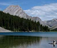
The trail to Elbow Lake is one of the busiest in Peter Lougheed Provincial Park and likely has the highest volume of users of any trail within the Opal Range. The distance to Elbow Lake is short, only 1.0 km to the lake, and provides the only backcountry campground in this part of the park. As well, the scenery is fantastic, the trail, though steep in parts, is well maintained and clearly signed. Also this trail provides access to the southern edge of the popular “Elbow Loop” trail, mostly for mountain bikers, equestrians and hunters in the fall.
To gain the lower west or south slopes of ‘Little Tombstone’ you need to ascend and descend ‘Piper Pass’ (unofficial name) and head north into the ‘Paradise Creek’ (unofficial name) drainage. In Piper Creek there is no official trail and two river crossings are required to gain the trail. This trail is excellent and very well trodden, it is along the eastern bank of Piper Creek and leads all the way to Piper Pass, but can be difficult to locate, but well worth the effort to find since the lower section of the valley is fairly treed and the bushwacking unpleasant. Best method to find the trail is to aim for the South Ridge of “South Tombstone” from the Elbow River trail (old road), at first through open meadows, then drop in the low Piper Creek valley, cross the creek, and just up slope, the trail parallels the creek.
 Elbow Lake Elbow Lake |
From Piper Pass |
 View from Piper Pass View from Piper Pass |
|---|
Once in the upper drainage of Piper Creek, head north towards a high col (outlier of Mt. Jerram, ‘Cat’s Ears’; and Mt. Tombstone col; Piper Pass). From Piper Pass hit north in the drainage of “Paradise Creek”. About 1.5 kilometre north of the pass, the central part of the drainage becomes steep and a large scree on skier’s left (west side) provides an easy descent into the lower valley and a wide canyon. We didn’t drop into the creek here, instead we traveled further north to a treed bench and set a camp below he steep East Face of Mt. Jerram (50.71, -115.05). Eventually we descended/ascended a steep head wall to get access to Paradise Creek. About 3 kilometre north of Piper Pass, a large meadow provides a landmark to head east to the easy west slopes of Little Tombstone.
 View to Piper Pass View to Piper Pass |
 View to bench bivy site View to bench bivy site |
 Big meadow in Paradise Creek Big meadow in Paradise Creek |
|---|
Little Elbow River Trailhead
The Little Elbow River / Elbow River loop trail is a popular and busy summer trail, but since the vehicle access is closed over the winter months (December 1 to May 15), it generally quiet, even though it is legal to snowmobile the loop. A mountain bike is highly recommended for this approach.
 Little Elbow trail head Little Elbow trail head |
 Start of Little Elbow trail Start of Little Elbow trail |
 Romulus turnoff Romulus turnoff |
|---|
Approach to East Ridge
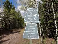
From the Little Elbow trailhead take the wide double track trail (former road), past the Mount Romulus backcountry campground turnoff, to low end of the East Ridge of Little Tombstone. Near the bottom of the ridge, the trail runs perpendicular to the end of the ridge and it is easy to see from the trail; approximately 15.5 km from the trailhead (17.5 km from parking area), about 50.72, -115.00 leave the trail and head directly west. This requires a short downhill to the Little Elbow River which is easy to wade, then a short uphill to reach open scree slopes on the very bottom of the ridge. Follow this open slope up hill and the ridge gets more defined as you gain elevation.
 View to ridge from trail View to ridge from trail |
 View up road View up road |
 Lower scree slope Lower scree slope |
|---|
Approach to North Ridge or Paradise Creek (West Slopes)
From the Little Elbow trailhead take the wide double track trail (former road) to the Mount Romulus backcountry campground turnoff. This turn off is very obvious and has a directional sign. This turn is 11.5 kilometres from the start of the trail; about 13.5 km from the parking area. The Little Elbow River splits and takes a hard south turn near the Mt. Romulus backcountry campground, the other river branch heads west and soon (about 1 km from the campground) splits into a west and north branch.
From the main Little Elbow trail, the connector trail to the campground is about 500 metres, heading north east from the turnoff. Once at the campground, ford the south branch of the Little Elbow, a good and obvious trail heads west from the campground. This trail soon climbs a short steep hill, but easily bikeable. Continue on this good trail for about 4 km. From this location you likely could gain access to the north slopes of Little Tombstone. If heading to the west slopes, head west, south-west on a reportly a good trail into Paradise Creek. A large meadow exists in centre of the creek, about mid valley, from this meadow there is an excellent view to the west slopes of ‘Little Tombstone’. Light bushwacking easily reaches the low angle and open slopes and then scree of the west slopes of the peak.
When to Climb
Typical Canadian Rockies situation; best conditions for a high elevation alpine rock route is July to early September. Little Tombstone’s low elevation and position extends the summer season and is usually dry from May to late October..Route Descriptions
Searching all published and online resources, we found no record of an ascent. Within the summit cairn we found an old register left in 1975 by S. Toporowskj and D. Smith, in an old small jar (baby food maybe) in the summit cairn. The only entries were: Old register Old register |
 First ascent note First ascent note |
 Our ascent note Our ascent note |
|---|
• “Janelea Mountain” S. Toporowskj and D. Smith, July 3, 1975. Ascent by North Ridge.
• Jim Palmer, Rita Polt and Jerry Piro. September 11, 1977. Ascent by East Ridge.
• John Martin. August 19, 1986. Ascent by East Ridge.
• An entry I couldn’t read.
• Kevin Barton, Scott Berry. September 19, 2016. South Ridge. I kept our entry simple since paper was brittle and falling apart).
 Known routes
 - North Ridge, scramble
First ascent route to the summit. First ascent by S. Toporowskj and D. Smith, July 3, 1975. In the summit register, the name of “Janelea Mountain” was applied.
- East Ridge, scramble
Jim Palmer, Rita Polt and Jerry Piro. September 11, 1977. I attempted the East Ridge in October 2012, but verglas on a 5.3 rock step stopped my solo attempt.
 Lower scree slog Lower scree slog |
 Mid point up East Ridge Mid point up East Ridge |
 Cliff band at 2600m Cliff band at 2600m |
|---|
- South Ridge, scramble
From our camp below he steep East Face of Mt. Jerram (50.71, -115.05). Eventually we descended/ascended a steep head wall to get access to Paradise Creek, across the valley and up the simple west slopes of Little Tombstone.
 Our route up and down Little Tombstone
We did gain the South Ridge up to the southern summit (had a fun series of towers that we scrambled up), then hiked up the South Ridge to the summit, bypassing one tall/steep gendarme. We descended straight west off the summit on scree and slabs back to the creek.
 Lower scree slog Lower scree slog |
 Sun on lower south summit Sun on lower south summit |
 South Ridge South Ridge |
|---|
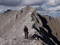
 View to summit View to summit |
 Nearing summit Nearing summit |
 Summit cairn Summit cairn |
|---|