
-
 2741 Hits
-
 86.85% Score
-
 23 Votes
|
|
Mountain/Rock |
|---|---|
|
|
45.56304°N / 7.41537°E |
|
|
Mountaineering |
|
|
10226 ft / 3117 m |
|
|
Overview
This mountain is located between the Little Arolla (3.232m) and Punta del Rossin (2.946m), or rather between the Colle dell'Arolla (2.892m), placed between the Valeille and Vallon adjoining Bardoney, and a 2.899 meters depression, Once you've not crossed generally and placed between the two Summit. It is massive and imposing "Cima" and consists of four main ridges and as many sides. While the former were more or less practiced, the latter do not know climbing, also because they consist of long, steep grassy slopes mixed with very broken rocks, crumbling and therefore very dangerous. The Normal Route along the Ridge South, results short but not always easy; especially in the final part, after having crossed the West Crest, which presents some roughness that can be bypassed immediately to the West (from I°+ to II°+, and, remaining on the edge of the ridge, also III°-). It also requires a lot of attention, in case of lack of visibility or fog, in finding the right passages of the route to reach the Colle di Arolla (2.892m). The Northern Ridge is easy but long, above all if you walk it in its entirety, also bypassing Punta delle Loie (2.674m) and Punta del Rossin (2.946m). Otherwise, from Alpe di Bardoney continue for a short distance on path no. 15A. Then head towards the SW and reach a barely mentioned rocky ridge at an altitude of 2.550/600 meters and follow it up to the watershed crest at an altitude of 2.926/8 meters; from this continue, always on detrital terrain, until you reach the Northerner front peak (3.076m). After an easy and wide collar you reach the Summit. While the Western offers direct access but very long and somewhat complicated. Even if, going up the Vallone delle Chesère (which opens just before reaching the Alpe di Valeille), it is possible to easily enter it in different points, mostly in the first part before the same stretches in a pseudo straight line; it should also be noted that it does not reach the Summit directly but joins the South Crest just before the Vertex. As for the difficulties, they do not exceed the II ° or a little more while, remaining on the edge of the crest; while the approach part requires some attention in not confusing the three existing crossroads: take the first at an altitude of 1.797 meters through which you ford the Torrent de Valeille. while the others, always deviating to the East from path no. 15 for the Guido Antoldi-Laura Malvezzi Bivouac, go to the Valloni di Arolla. On the other hand, an Eastern "Crestone" descends, very steeply in the direction of Torrent de Bardoney, making a "rocky comma" facing North at the base; the same, which was climbed on a single occasion in July 1983, divides the eastern side of the mountain into two facing walls to the Northeast and Southeast respectively. This great and robust ridge thus forms a sturdy edge of steep and stacked rocks which, from the base at an altitude of 2684 meters , with a single leap of over 430 meters directly reaches the Summit. The ascent of the same is not very difficult (from II- to III-) allowing many bypasses but rather delicate due to the quality of the rock which is not always good and, at times, covered with dangerousgrass. Beautiful views on the Valley of Bardoney (towards East) and the Oriental Graian Alps and Valeille to the nearby Chain of the Apostles (immediately to the West) and in distance to the Gran Paradiso.

First Ascents
- First on the Summit: Unknown.
- In winter: Unknown.
- Eastern "Crestone": Osvaldo Cardellina and Marco Cossard, (Jul 13th, 1983), in ascent from Lillaz, Loie Pastures and Loch, fork 2217 meters nearby Plan des Goilles, Bardoney Alp; in descent through South Ridge to Arolla Col with subsequent crossing up to the Bardoney Hill and return towards Bardoney Alp, Crêt.
- Integral Traverse North/South (Loie-Rossin-Tsesère): Osvaldo Cardellina, Christian Cardellina and Marco Cossard, Jul 27th, 1983, in ascent by North-northwest Crest with crossing on the thread of the ridge up to the Arolla Hill; in descent through South Ridge to Arolla Col with crossing up to the Bardoney Hill and return towards Bardoney Alp, Crêt; Goilles Dessus, Lillaz Hamlet.
Getting There
BY CAR:- From Torino, Milano, etc: Motorway A5. Exit at Aosta Ovest. Drive to the near Aymavilles. Follow the directions for Valle di Cogne.
- From Switzerland: through the Grand Saint Bernard Tunnel or the namesake Pass. Drive to Aosta, then follow the direction for Courmayeur on SS.26. Just after Sarre, turn to the left, in the direction of Valle di Cogne.
- From France: through Mont Blanc Tunnel or Petit St. Bernard Pass. It isn't necessary to take Motorway A5: you can drive on SS.26, in the direction of Aosta. Before arriving at the Village of Sarre, turn right following the sign for Valle di Cogne. After Aymavilles, the SR.47 crosses the Villages of Vieyes, Epinel and Cretaz and after about 25 Km arrives at Cogne (1.534m). From Cogne you can get the Village of Lillaz (1.617m).
BY PLANE:
- Aeroporto "Corrado Gex" Saint Christophe (Aosta).
Approach and Route
Approach Lillaz Fraction through Valeille Vallon: from Lillaz, through the trail base n° 15 in South, towards a crossroads (1.910m); from this, fording the Torrent of Valeille, reach, through the path n° 15a in East, the immediately (to the left) adjacent homonym Pasture (1.902m; TE/F; 1h'15/1h'30). Continue with the same direction up to the Arolla Hill (2.892m), between Piccola Arolla and Punta delle Tsesère (3.117m; E/F; 1h'40/2h'10). From the Pass in North-northwest towards Pointe de Chesère, by the quite easy Southern Crest overcoming with some little rock the various altitudes or avoiding the same to the left (West) up to the junction 3.033 meters with the Western Ridge from Valeille Vallon (I°+/II°-); by this last briefly and easily on the Summit (I°; EEA/F/F+; 1h'00 from hill; 4h'45/5h'15 in total). Descent: From the same Route.
 |
 |
 |
 |
 |
Avvicinamento dalla frazione di Lillaz attraverso la Valeille: dal Villaggio di Lillaz, tramite il sentiero di base n° 15 in direzione Sud, verso l'incrocio dei sentieri (1.910 m); da questo, guadando il Torrent de Valeille, raggiungere verso Oriente per mezzo del sentiero n° 15a, l'omonimo ed appena adiacente a sinistra (Est) alpeggio (1.902 m; TE/F; 1h'15/1h'30). Continuare con l'identica direzione insino al Colle d'Arolla (2.892 m), collocato tra la Piccola Arolla e la Punta delle Tsesère (3.117 m; E/F; 1h'40/2h'10). Dal Colle e verso Nord-nordovest in direzione della Pointe de Chesère, per mezzo dell'abbastanza facile Cresta Meridionale superando le varie asperità oppure aggirando le medesime sulla sinistra (Ovest) fino alla congiunzione 3.033 metri con la Cresta Occidentale (I°+/II°-) proveniente dal Vallone di Valeille; tramite quest'ultima facilmente ed in breve tempo alla Vetta (I°; EEA/F/F+; 1h'00 dal colle; 4h'45/5h'15 in totale). Discesa: Lungo la stessa Via.
Difficulties
This route can be considered EEA/from F to F+.L'itinerario è da classificare in EEA/da F a F+.
Equipment
For High Hiking gear; in winter with ice-axe and crampons.Da Alto Escursionismo; in inverno con piccozza e ramponi.
Red Tape
Within the borders of the P.N.G.P. (Parco Nazionale del Gran Paradiso), at the moment (summer 2004), dogs generally are not allowed, except on a couple of trails, and camping is forbidden (except for climbers from sunset till dawn). No fees are due.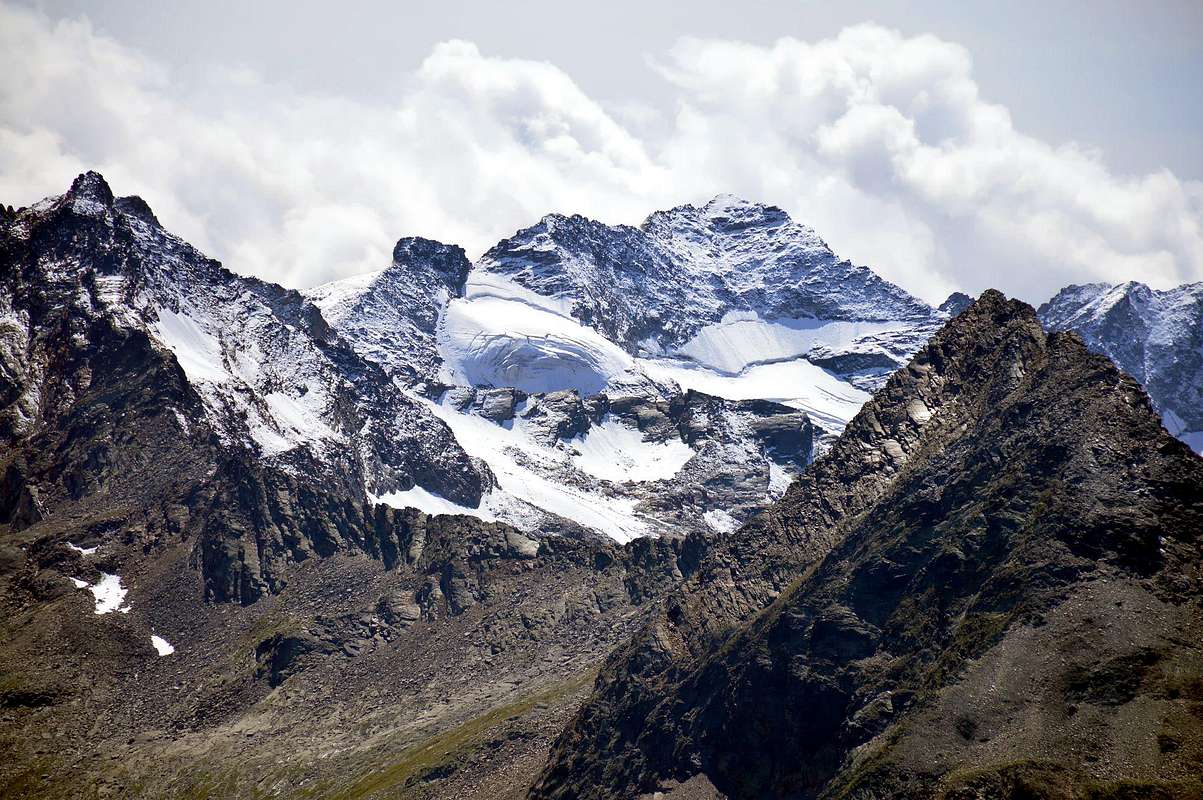
Campings
- Wild camping in the Parco Nazionale del Gran Paradiso is strictly forbidden!!!
Mountain Conditions
- You can get meteo information at the official site of the Regione Valle d'Aosta:
- Valle d'Aosta Meteo
Webcam
- WEBCAM on Aosta Valley:
- Webcam
Books and Maps
BOOKS:- "Guida delle Alpi Occidentali" di Giovanni Bobba e Luigi Vaccarone C.A.I. Sezione di Torino Volume II (parte II), 25 Maggio 1896.
- "Gran Paradiso" di Pierandrea Mantovani e Renato Misischi, Ed. Rassegna Alpina, 1974.
- "Diari Alpinistici" di Osvaldo Cardellina e Indice Generale accompagnato da Schedario Relazioni Ascensioni 1964-2021 (inediti).
- "Gran Paradiso" A. Gegenfurtner, G. Klotz, F. Müller, Ed. Bergverlag Rudolf Rother, Monaco 1980 (in tedesco).
- "Gran Paradiso" G. Klotz Ed. Bergverlag GmbH Rother, Monaco 2005 (in tedesco).
- "Gran Paradiso - Itinerari Alpinistici e sci Alpinistici" di Franco Brevini Ed. Musumeci, Giugno 1982.
- "Il Parco Nazionale del Gran Paradiso (Valli di Champorcher-Clavalitè-Saint Marcel-Laures-Cogne-Valsavarenche-Conca di Pila" di Giulio Berruto 3/volume 2°, IGC, Torino 1981, 2a Ed. 2000. (in Italian)
- "Guida dei Monti d'Italia-Gran Paradiso Parco Nazionale" E. Andreis, R. Chabod, M. C. Santis, Club Alpino Italiano/Touring Club Italiano, prima Ed. 1939; seconda Ed. 1963; terza Ed. 1980.
 |
 |
 |
 |
- Kompass "Gran Paradiso Valle d'Aosta Sentieri e rifugi" Carta turistica 1:50.000.
- I.G.C. Istituto Geografico Centrale "Gran Paradiso-La Grivola-Cogne" Carta turistica 1:25.000.
- A.IA.T "Cogne Gran Paradiso Cogne Aymavilles-Walking map" 1:25.000.
- L'Escursionista "Valle di Cogne Carta dei Sentieri" (n° 10) 1:25.000.
- L'Escursionista "Tour de la Vallée de Cogne Grand Paradis" Carta dei sentieri 1:25.000.
Important Information
- REGIONE AUTONOMA VALLE D'AOSTA the official site.
- FONDAZIONE MONTAGNA SICURA Villa Cameron, località Villard de la Palud n° 1 Courmayeur (AO) Tel: 39 0165 897602 - Fax: 39 0165 897647.
- SOCIETA' GUIDE ALPINE DI COGNE Tel. 347/9473526 – 328/1373728.
- A.I.NE.VA. (Associazione Interregionale Neve e Valanghe).
- A.IA.T. Cogne Gran Paradis via Bourgeois n° 34 Tel. 0165-74040. E-mail: aiat@cogne.org
- Ezio Sport articoli sportivi - via Bourgeois n° 64 Tel. 0165-74204.
Useful Numbers
- Soccorso Alpino Cogne (SAR) Tel. 3482685406.
- Protezione Civile Valdostana località Aeroporto n° 7/A Saint Christophe (Ao) Tel. 0165-238222.
- Bollettino Meteo (weather info) Tel. 0165-44113.
- Unità Operativa di Soccorso Sanitario Tel. 118.