
-
 15151 Hits
-
 81.24% Score
-
 14 Votes
|
|
Mountain/Rock |
|---|---|
|
|
39.13140°N / 105.3223°W |
|
|
Douglas |
|
|
Trad Climbing |
|
|
Spring, Summer, Fall |
|
|
8285 ft / 2525 m |
|
|
Overview
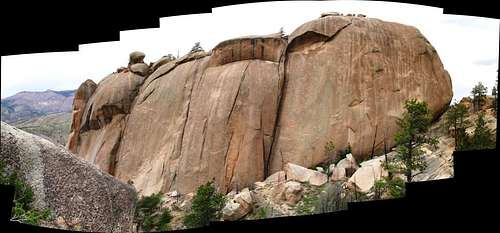
Summit block panoramic. Courtesy Doug Shaw.
The Big Rock on ListsofJohn:
Elevation  : 8,285'
CO Rank: 3474
CO Prominence Rank: 2360
County: Douglas
Quad: Cheesman Lake
: 425'
: 8,285'CO Rank
: 3474CO Prominence Rank
: 2360County
: DouglasQuad
: Cheesman LakeCoords : 39.1314°N, 105.3223°W Notice
Rise : 39.1314°N, 105.3223°W Notice: 425'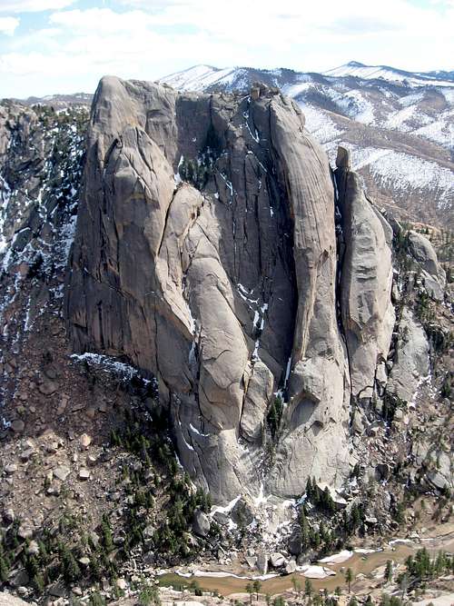
Getting There
Big Rock Candy Mountain, while being not that far away in a straight line, is not quick and easy to get to. From Denver, it takes almost 3 hours. There are two main routes from the east side of the South Platte river - one down 285 and one down 85 (Santa Fe), but they both merge at the same place for the final bit of a drive.
Some folks enjoy access from the west side of the river, but this forces you to cross the river twice. If it is hot outside, that might not be too bad.
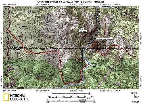
Topo with roads
East access down 285/126:
1. Head southwest on US-285 S
20.7 mi
2. Turn left onto Co Rd 126/Pine Valley Rd
Continue to follow Co Rd 126
24.6 mi
3. Continue onto CO-67 S
8.8 mi
4. Turn right onto Abbey Ave
0.2 mi
5. Turn left onto Westcreek Rd
0.6 mi
6. Slight right onto Co Rd 68/W Stump Rd
2.5 mi
7. Continue onto Forest Service Rd 360
2.6 mi
8. Turn left to stay on Forest Service Rd 360
5.1 mi
9. Turn right onto Forest Service Rd 205
Destination will be on the left
3.5 mi
Unknown road
East Access down 85 to 67:
1. Head southeast on CO-470 E/E470 E
10.7 mi
2. Exit onto US-85 S/S Santa Fe Dr
10.2 mi
3. Turn right onto CO-67 S/Manhart Ave
Continue to follow CO-67 S
36.1 mi
4. Turn right onto Abbey Ave
0.2 mi
5. Turn left onto Westcreek Rd
0.6 mi
6. Slight right onto Co Rd 68/W Stump Rd
2.5 mi
7. Continue onto Forest Service Rd 360
2.6 mi
8. Turn left to stay on Forest Service Rd 360
5.1 mi
9. Turn right onto Forest Service Rd 205
3.5 mi
Unknown road
West access:
1. Head southwest on US-285 S
20.7 mi
2. Turn left onto Co Rd 126/Pine Valley Rd
Continue to follow Co Rd 126
21.9 mi
3. Turn right onto Wigwam Creek Rd
2.0 mi
4. Turn right onto Goose Creek Rd
6.3 mi
5. Slight right onto Co Rd 211/Goose Creek Rd
0.2 mi
6. Slight right at Matukat Rd
0.8 mi
7. Turn right onto Co Rd 211/Goose Creek Rd/Matukat Rd
1.5 mi
8. Slight right onto Co Rd 211/Goose Creek Rd
Continue to follow Co Rd 211
5.2 mi
Co Rd 211/Matukat Rd
This puts you at the ridge. From there, you have to descend the gulley/old road to the river bottom, then cross the river.
Route
There are many, many, many routes to the summit of this giant rock. Please see the individual topos for best beta:
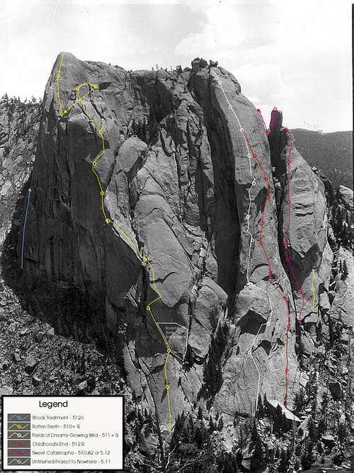
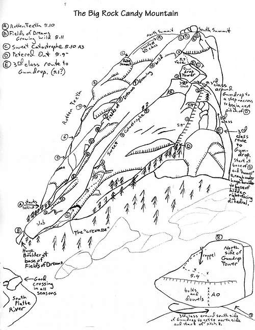
Routes visible on the image.
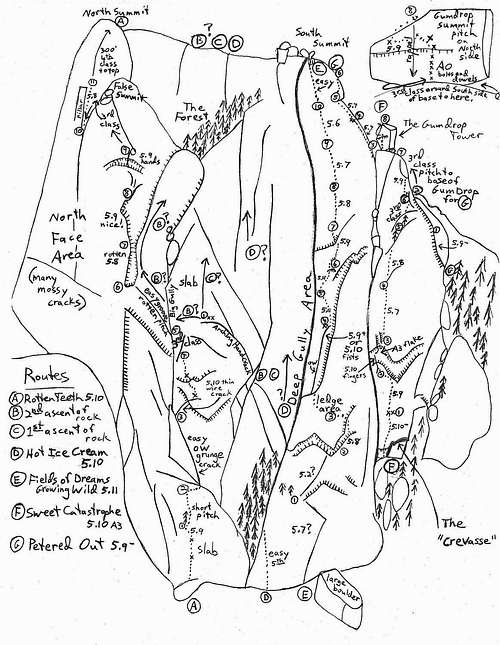
Hand drawn topo from The Peters (Gallagher and Williams).
From Ken Trout's book, South Platte Rock.
Red Tape
Weather and stiff climbing are your worst obstacles. The road to get in there requires either 4WD with low range or motorcycles/ATV to get back in there.
Climbing red tape: Bring your game. Even though the easiest route is rated 5.7, it is a runout heady thin face. Getting down from the summit requires at least 1 60m rope and a double rappel. Two 60m ropes will get you down from the summit in one long rappel.
When to Climb
Whenever it is warm enough to climb, this thing is in season. It doesn't hold snow, but access might be difficult. I'd say April to October/November, depending on what the season is holding.
Camping
Camping is permitted in all areas of Pike National Forest. There are a few campgrounds sprinkled around, but this is mostly a peak that you do in a day. PLEASE be sure to practice Leave No Trace principles while camping and or/hiking in this already heavily impacted area.External Links
Amazon has a good selection of books for Big Rock Candy Mountain and for the South Platte area:South Platte Rock by Ken Trout, The South Platte Rock Climbers Guide by Peter Hubbel, The Brown Book Of Lies, South Platte and Garden of the Gods (old version), Rock Climbing Colorado by Stewart Green
There is a good page on The Big Rock on Mountainproject.