-
 50751 Hits
-
 90.79% Score
-
 34 Votes
|
|
Mountain/Rock |
|---|---|
|
|
45.82260°N / 6.88420°E |
|
|
13490 ft / 4112 m |
|
|
Overview
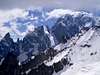
This incredibily elegant, ship-shaped peak of the famous Peuterey ridge of Mt. Blanc is the most difficult indipendent 4000m summit of the Alps, one of the most photographed (it's very visible from the italian entrance of the Mt. Blanc tunnel), but also one of the least visited. From whatever side you try to climb it, the Aiguille Blanche is a very serious peak. The sense of isolation and wilderness one feels at the summit is unparalleled in the Alps.Despite its fantastic shape, most of "la Blanche" is made of mediocre rock, the best area being the one below the subsidiary Pic Gugliermina, whose important climbing lines deserve to be covered in a separate entry. Moreover, the glacial changes of the last two decades, and the huge Brenva landslide of 95, have made the traditional Freney and Brenva access very difficult, greatly limiting any traffic on the Schneider Couloir (the former normal route) and the pristine and classic North Face.
Thus, for all practical purposes, the most common way to climb the Blanche today is... descending from its rocky sister, the towering and sinister Aiguille Noire, via one of the scariest rappel descent of the entire Alps.
Let's call things with their name - this is not a mountain for peak baggers or summit collectors (most of the books about the Alpine 4000's purposefully avoid to describe its normal route). While it's one of the interesting and important summit of the Alps, it's also very, very serious. A sudden change of weather, or a disabling accident may have catastrophical consequences here - the Blanche summit area is completely exposed to the deadly western winds, and there's NO simple or straightforward way to descend from the summit, even in good weather. If you attempt to climb "la Blanche", make sure you know what you're doing.
Thanx to OM, the former maintainer
 |  |  |  |  |
Getting There
From Courmayeur (Italy)- By car through the Val Veny mountain road until the car park at La Visaille / Plan Lognan or (500 m. below) at Plan Veny (near the picnic area). Private access to this road is regulated from 1 to 20 August .
- By the bus service – one trip each 40 minutes. In Courmayeur the bus can be taken from the Bus Station plaza.
The Brenva side is accessible the Vallee Blanche, itself reachable from Chamonix via the Aiguille du Midi "telepherique" or Courmayeur via the Pt. Helbronner station cablecar
 |  |  |
Red Tape
In the area minerals and flowers gathering is forbidden. The same goes for making fires, and free camping under 2500m. Hunting and fishing goes under local seasonal rules (ask to the police in Courmayeur).Remember that private access to the Val Veny road is regulated from 1 to 20 August
 |  |  |
Huts
- Franco Monzino hut (2561 m.)Property of the the Compagnia Delle Guide di Courmayeur , 104 beds + 10 in the winter shelter, open with warden from June 15th to Sept. 15th, tel. +39 165 809553. Restaurant service, showers, emergency radio, etc. The Franco Monzino hut is one of the best of the entire Mont Blanc chain. It’s not only a very well built and comfortable construction, but it’s also strategically placed between the Brouillard and Freney basins, in one of the most savage and beautiful area of the Alps. However, this hut sees relatively low traffic in relation to the rest of the massif, partially because of the not elementary (but rather short) access, partially because many climbs on the farther side of the Freney are now inaccessible – due to the state of the glacier – and most of people doing the difficult routes of the Brouillard and Freney pillars tends nowadays to use the higher Crippa and Lampugnani bivouac huts.
Access (diff. F/II°, 2-2.30 h, 1000 m.)From 1970 until 1999, the starting point of the access trail was Plan Lognan / La Visaille, and the trail was, in the first part, the same used to reach the Jardin du Miage and the Marmot lake. However, after the catastrophical 2000 flood the most commonly used point of acces is the riverside car park at the Bar Pramotton / public picnic area 500 m. before Plan Lognan (just before the two road curves). From there, follow the trail (marked “Chalets Du Freney”) along the river, then cross the Dora over two successive bridges. Few meters after the second bridge, there a very visible signopoint – choose “S16 – Rif. Monzino”. The trail enters the beautiful pine forest, ascending following some steep curve (good chance to spot wildlife here, but beware the vipers), then turns decidedly west. When the forest ends, the trail cross the small but wild Freney torrent (that can be absolutely impassable when the snow is melting!!!), then turns north and begin ascending the grass slope until a first easy rock barrier (some I°). After that, there’s another grassy slope, which in 30 minutes brings you under the second and far higher rock barrier (130 m.). Ascend this following the metallic chains that equip the trail (exposed, some II° - be careful if wet or if you have another party above – wear you helmet!). At the top of the barrier, simply follow the trail again, until the well visible hut above.If you’re coming down from the Col De La Seigne, there’s a shortcut at Plan Lognan – go down the road until the (now unused) lower station of the Monzino hut service cablecar . Just befor the station there’s a trail marked by a huge “Peuterey camping” red arrow. Go down this trail, which descends the steep slope into the forest nearby, reaching the previous trail just before the first bridge.
- Alberico and Borgna bivouac hut (3674m.) This is a metal and wood structure with room for 15 people, always open, w/o warden. Property of the Turin section of CAAI, call +39 11 546031 for more information.
Approach (diff. PD+, 2-2.30 h): From the Torino Hut (3375 m., reached via the gondola starting from Courmayeur-La Palud) cross the nearby Col Des Flambeaux (3407 m.), easily visible because it's located right under the ugly suspended pillar of the Valleè Blanche cablecar), then turn left and cross right under the north face of the Aiguille Des Toules. Take the W direction, pass near the N face of the Tour Ronde (not too near, in summer there's some rockfall danger), and then, following a very genlte slope, point right towards the ice slope of the Col De La Fourche (it's the one to the left of two short rock spires that look like a prong - the "Fourche": they don't call it the Combe Maudite - "the cursed valley" - for nothing!)At the the base of the couloir leading to the col (very steep, actually a short proper ice climb!) cross the rimaye where it's possible (in some season it's quite awkward) then go up until the col. Beware of the "traffic" - there's usually someone above you that's literally digging the slope with his axe bringing down huge chunks of ice. At the col, turn left and after few metere you'll see the hut just below you.
If the ice slope is in desperate conditions, use the rock rib to the right (some loose rock)
Beware: some map and some out-of-date guidebook still report the presence of the Ghglione bivouac hut at the nearby Col du Trident. The bivouac isn't there anymore! It was removed few years ago because the rock platform where it had been built was literally sliding down the Brenva. Plans to replace it have been made, but never finalized.
- Brenva bivouac hut (3140m). Small construction of metal and wood, room for four people, without any accessory. Property of CAAI Gruppo Occidentale, Via Barbaroux 1, 10122 Torino, tel. +39 11 546031. One of the original bivouacs built by the CAAI (the elite branch of the Italian Alpine Club) in the 1920’s to provide shelter for the growing number of climbers tackling the difficult routes on the Italian side of MB, the Brenva bivouac was quickly superseded by the better placed Fourche bivouac in 1935, and is now rarely used except as the objective of a hike in lonely and wild places. While the access has no technical difficulties, is long, not evident at all and quite adventurous (especially in less than pristine weather). When you go there, remember that you’re treading on the same steps of the first explorers of the mighty Brenva face!
Access (diff. F+, 5-6 hours, 1700m.): From Entreves (1360m., 3 km. from Courmayeur, just below La Palud and the lower station of the Helbronner telepherique), take “Strada Della Brenva”, the road that pass before the village’s church, and cross the highway to the MB tunnel entrance (careful here). On the other side the road continue, becoming a dirt road that goes to the stone/sand quarries used for the tunnel and the highway maintenance. Don’t go there, but take a trail on the right that enter a sort of small, flat valley on the left flank of the Mt. Frety. When the road take a steep turn to the right, take another trail that goes on the opposite site. Cross the torrent (often difficult), then go up the other side toward a group of huts (the “Casolari Inferiori Della Brenva”), then, 50m above, another little hamlet (the “Casolari Superiori Della Brenva”). At this point the trail goes up toward the enormous Brenva moraine. At your right, you’ll see a sort of big grassy couloir surrounded by trees (it’s called the “Comba Dou Lou”, the Wolf’s Valley). Go up there for around 150m., then turn left and go (some trace and some indication) up the faint trail until the (beautiful, especially in autumn) wood ends. Now, you’ll see a grassy slope that goes up and towards the left. Follow it, the go down some meter on some easy looking but quite exposed slabs (very dangerous if wet or snowy, a slip here can be fatal.) In front of you there’s another torrent, which becomes a waterfall few meters to the right. Cross it (again, may be impassable in some moment of the year), and go up on the other side, up another slope that is contouring the huge ridge on the right of the Brenva basin (called the Dar Desò). Cross another little wood, turn right again and you’re now on the Brenva basin proper, above the right bank of the glacier (fantastic view on the Peuterey ridge). Follow an area of immense blocks and colossal slabs, then reach another nice looking grassy spot (the Dar D’Amon, 2650 m.) right below the south face of the Aiguille De La Brenva, where is very easy to spot wildlife. From Entreves to here it’s 3.30h.If you can resist the temptation to stop here and spend the rest of the day sunbathing, go towards the glacier aiming at the rock island where lies the bivouac (it’s invisible from here, but there are some marks on the boulders to point the way.). Cross the glacier (beware the crevasses!) and reach the island. From here, faint traces among snow and rocks (some very easy third class terrain) go up 300m to the right, until you reach the terrace of the bivouac, in 1,30/2h from the Dar D’Amon.
An alternative approach is to reach the Dar Desò from the Mt. Frety cable car station via the trail marked S20a and the Rochers de la Brenva. While the new trail make reaching the top of the Rochers quite straightforward, the descent on the opposite side is not evident, scary and awkward in some place, and the hour you may save it’s not (IMHO) worth bothering. Someone may have different opinions on this, however – check as usual with the Courmayeur Guides
- Craveri bivouac hut (3445m) Small construction in metal and wood, room for four people, some wool blanket inside. Property of CAAI Gruppo Occidentale, Via Barbaroux 1, 10122 Torino, tel. +39 11 546031. Still the eternal question – what’s the most remote, loneliest, most difficult-to-reach hut of the MB range? While the Quintino Sella gets my vote for the atmosphere, the Canzio for isolation and the Jachia for the mere “aren’t we arrived YET?” factor, there’s little doubt that, given the actual conditions, reaching the Craveri is one hell of a ride. Built by the CAAI to be used as emergency shelter for parties attempting the Peuterey ridge (thus making the ridge less serious than it was before – and it’s still VERY serious) its normal access (over the west couloir of the Breche Des Dames Anglaises) has been always a climb-within-the-climb. With the current difficult passage Freney, the most frequent manner to get there is via the rappel descent from the Aiguille Noire. In other words – if you arrive at the Craveri, you’re a decent mountaineer…
Access: (diff D+, 7 hours, 800 m. of height gain but much longer) This is the classic access to the hut – it’s nowadays very difficult because of the glacier conditions! Some party has reported up to 10 hours just to cross the Freney, and even with a good snow cover don't expect less than 3! From the Monzino Hut take a trace up the grass & rock slopes above, in the direction of an evident moraine and the little Glacier du Chatelet, aiming at the evident breach between the Aiguille Croux and the Pt. Innominata - the Col De L’Innominata. Cross the little glacier, climb a first barrier of easy, low angled rocks, then go across a snowfield (that was not there in 2003) and a wide chimney-couloir, easy but made of very unsound rock, up to the Col saddle (magnificent, one-of-a-kind panorama on the upper Freney and the Peuterey ridge. A little below the saddle, a plaque remembers Andrea Oggioni, Walter Bonatti’s longtime companion, who died here in 1961 during the Central Pillar disaster). Downclimb or abseil down the other side, then cross in some the glacier, aimin at the evident couloir coming down from the Breche Des Dames Anglaises (you’ll have normally to go first UP the glacier then, from the middle, come back down toward the other bank). Cross the rimaye (often difficult), then go straight up the Breche couloir (normally iced, it may be an alternative to climb the rock on the right hand flank.) The entire couloir is dangerous in summer because of stonefall – don’t linger here. At one point you’ll reach an evident bifurcation. Take the left hand direction (towards the Breche Nord) climbing on normally dry but very steep rocks (some passage of III°) until you reach the Breche and the bivouac Craveri. With lot of snow it may take a bit to locate it – it’s 10 meters to the left and a coupleof meters up the saddle, on the Brenva side, at the end of a large ledge, under a small overhang.It used to be a feasible alternative to cross the Freney via the Brogliatta, the passage below the South-Est face of the Aiguille Croux. In the last few years the level of the glacier is down of at least 7 meters, and just the transit from the rock to the glacier may be simply impossible. With PLENTY of snow it may become more or less accessible again (ask at the Monzino hut or to the Courmayeur Guides). If so, cross the glacier towards the mighty W face of the Aiguille Noire, then to the bottom of the couloir coming down from the Breche Sud des Dames Anglaises. Once there, leave the glacier and coast it on the lower rocks of the Dames Anglaises “base”, towards the Breche Nord couloir and the previous itinerary (some rockfall danger here)
Routes Overview
Coming Soon!Pictures linked from the Mount Blanc group page, courtesy of Gabriele Roth:
 -
-  -
-  -
-  -
- 
Mountain Conditions
For all informations on the mountain conditions you MUST contact the Guides Company of Courmayeur (tel. +39 0165 842064; fax. +39 0165 842357; email info@guidecourmayeur.com). They’ve an excellent local weather service, and are always well informed on the conditions up there.A new official source of informations on mountain condition for the Italian side of the MB massif is the Fondazione Montagna Sicura , the Safe Mountain Foundation, a guide sponsored organism that work in collaboration with the French OHM to create a network of information exchange for alpinist. It's very important you check their multilingual website or contact them at
Loc. Villard De La Palud 1 11013 Courmayeur (AO)
Ph: 0039 0165 897602 Fax: 0039 0165 897647
E-Mail: villacameron@fondms.org
The quickest source of informations on the weather on the southern side of the massif is the webcam at
Remember that this cam "sees" only the central portion of the main ridge - Aiguille Blanche is located one mile to the left. This very informative site has also plenty of informations on accomodation, place where to eat, etc. in the area.
 |
When To Climb
Once primarily a summer target, as many other peaks of the area the Aig. Blanche has known a season of primarily winter traffic, mainly on the north face ice routes. However, the recent access trouble has made even this little traffic dwindle. It's clear., however, that even via the now almost exclusive access via the Aiguille Noire and the Dames Anglaises, attempting to reach the Aig. Blanche in a summer as hot as 2003 is almost suicidial. And so, the best moment to attempt this peak (as many others) as become the late spring and the early autumn, in cold and dry conditions.
Camping
Free camping in the Aosta Valley region is not allowed below 2500 m. However, it's tolerated if you don't create hassles or particular troubles. This includes, of course, making fires in the woods!Here's a list of camping in Val Veny, all accessible by car or by bus from Courmayeur. In strict alphabetical order:
- Camping Aiguille Noire (www.aiguillenoire.com, ) - in Val Veny, at Zerotta, near lower station of the chair lift. (tel. +39 0165 869041 Fax +39 0165 843097). A good place for families and big groups. Used to be also the cheapest, but price right now are almost the same everywhere.
- Camping Cuignon – in Val Veny between Zerotta and the military barracks (tel +39 0165 869073 Fax +39 0165 842861). This one is a bit of a question mark for me, because I don’t know anyone who’s been there. For outside it looks quite neat and smaller than Aiguille Noire
- Camping La Sorgente (www.campinglasorgente.net, ) – in Val Veny, in a clearing of the forest called Peuterey, exactly under the Mont Noir south face (tel. +39 0165 848209 or, in summer +39 0165 869089). The location of this one is gorgeous (the ancient forest nearby is said to have been a Celtic worship centre). They’re really climber-friendly, and the camping itself is well organised.
- Camping Grandes Jorasses ( www.grandesjorasses.com) in Val Ferret between Planpincieux and the golf course. (tel +39 0165 869708). Being near Planpincieux, it’s a lively and well placed on a partially wooden area.
- Camping Tronchey – in Val Ferret just in front of the entrance of the golf club, right under the monstrous Tronchey Wall of the Grandes Jorasses. (tel. +39 0165 869707). Nearby there’s Bar Tronchey (or “Chez Giulietta”), where at noon you can eat an incredible rabbit with polenta.
- If you’re willing to spend a little more, a nice alternative to camping can be the ( Chalet Val Ferret). It’s a seven room little hotel + restaurant at Arnouva, where the Val Ferret road ends – just in front of the opening of the Triolet basin. The place is beyond gorgeous, and you’re in a good position both for climbing and hiking. A guide who’s a friend of mine used it for his climbing stage for kids and was really enthusiastic. Also, you can ask the manager for any kind of indication on the nearest sport and trad climbs of the trendy Triolet area.
- On the other hand, if you don’t like camping and you’re tight with money, you can consider sleeping in one of the low altitudes “refuges”. There are the ( Elisabetta hut ), at the head of Val Veny near the Col De La Seigne, the ( Elena hut ) and the (UGET Monte Bianco hut) In all these places accommodation varies - the Elisabetta is quite spartan, the Elena almost a luxurious, the Monte Bianco somewhere halfway. If you want to consider staying there for several days, you’ve to book well in advance (In August and July these places become packed with hikers doing the Tour De Mont Blanc.)
External Links
- Aiguille Blanche sketches
Some route sketches taken for the old Vallot Guide
- Pictures taken on the Peuterey Ridge
seano - Dec 5, 2022 1:56 pm - Hasn't voted
New "standard" route?I climbed it in mid-July 2022, via the apparent "standard" route: from the Monzino hut, climb to the Eccles Bivouac via the Brouillard Glacier, then over Pic Eccles to Col Eccles, across to the Col de Peuterey and up the rock from there (5.6-ish?). In addition to crevasses on the Brouillard Glacier, there was significant rockfall getting down from Col Eccles on mix of snow, rotten rock, and bare ice. 2022 was an exceptionally dry year, but this side of Mont Blanc is changing quickly and becoming more dangerous; the Aiguille Blanche is probably best done early in the season.