
|
|
Mountain/Rock |
|---|---|
|
|
38.35410°N / 113.5867°W |
|
|
Beaver |
|
|
Hiking |
|
|
Spring, Summer, Fall |
|
|
9393 ft / 2863 m |
|
|
Wah Wah South
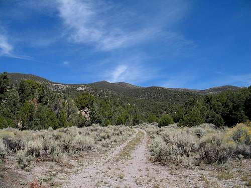
Eric Willhite's pic taken in early April
Overview
What? you ask. Another mountain in the Utah western desert? To that question I would answer YES. Each of these mountains is a gem and rarely visited which gives them a special appeal to someone like me. The fact that they are prominence peaks makes them even more attractive but for the moment, lets talk a bit about the peak and its area. There is nothing technical about them but getting to the area is the biggest challenge. It helps to have a high clearance 4WD vehicle and to be totally equippedand prepared for being in an isolated part of the state of Utah. That means, a full tank of gas, plenty of water and prepared for anything if you should suffer a vehicle breakdown. Do not count on cell coverage, it doesn't exist out in this area although a satellite phone might be nice to have along.
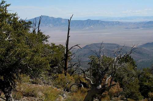
View from summit eastward
The Wah Wah Mountain range extends for 55 miles north and south in the western desert area of Utah but this peak is south of highway 21 and is the highest peak in the southern section of the range, separated of course by highway 21. However, while it is an intriguing area you need to be warned that this is really a remote place to visit. That is true of most of the mountain ranges in the western Utah desert but you really feel it when you make the effort to travel to this area. The name Wah Wah comes is an indian term and yes it does mean water but not exactly as one might think. Two sources report the meaning of "Wah Wah" as 1.) Good clear water and the second source says 2.) Salty or alkaline seep. Now those are pretty far apart so I looked up another source and it was even more confusing. I
quote a lady named Alexa Robinson. She gives the following perspective on the origin of the name, "Wah Wah":"Wah Wah Valley was named by the Indians because there is a rumbling noise that sounds like WahWah. They say it comes from Wah Wah Springs. You can be 40 miles from the springs and hear the sound is just as loud as if you are right at the springs. We could hear it over in the Escalante Valley 30 miles away just as loud. It would take spells of doing it sometimes 2 months without, sometimes once a day."
I vote for "good clear water".
The reason I was even interested in the Wah Wah mountains is because they contain two of Utah's 81 peaks that have over 2000 feet of prominence. For this page, we'll concern ourselves with the highpoint peak that is in the southern part of the range (below highway 21). Wah Wah peak 9393, has about 3000 feet of prominence (3104 to be exact) and it comes in at #35 on the Utah Prominence peak list.
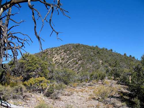
This is one of those peaks that you don't see readily from anywhere since other peaks that are nearly as high block your views. The area has a lot of scrubby brushlike trees that can make your progress slow and make your routefinding a bit more interesting. There is no trail or road to the top and this is probably more in character with the area. It is prime rattlesnake country all though I didn't see any. Maybe it is too arid for even rattlers.
Decent views are available from the summit area, particularly to the east and west and the dominant feature to the west is neighboring Indian Peak, a peak worth visiting and everybit as remote as this one. The best plan is to get both of these peaks on the same day and you can camp near Indian Peak which is better suited for camping.
Getting There
I will describe this from Milford Utah although you can come in from the west via the Great Basin National Park area. Road 21 is the key road and from Milford it goes like this:
Zero you odometer at the Oak Tree Inn Motel on the west edge of Milford.
Drive west for thirty miles until you reach Wah Wah summit. As you drop down the grade, watch for milepost 42 as the turn to the left that you want is just beyond it at the 34.2 mile mark. There is a very small BlM sign on the right side of the road indicating Lund and Vance Spring but it is easy to miss. Should you miss the left turn, don't despair, there is another turn off in a bit down the road. Assuming you made the correct turn off, you will encounter a crossroads at the 38.8 mile mark where you will turn left onto the Pine Valley road. Stay on this road until you encounter another road going left at the 43.7. Turn onto it and this will begin to take you towards the Wah Wah mountain range. At 46.2 miles, a road coming in from the right will be passed and you will note a sign indicating Pine Grove in 3 miles. Follow the road as it passes over a cattle grate and begins to climb a bit. The road will enter a canyon and stay on it until about the 52 mile mark. I found a spot on the side of the road and
basically just went cross country up the slope, using my GPS to guide me along with a map of the area.
It is possible that a jeep road that takes off to the north might provide easier access but I'll have to leave that information up to some future
person who tries that way. There is no right or wrong way up this mountain, you need to waypoint the summit and go accordingly, avoiding cliffs and the like.
Route information

My Route
I can offer no solid route as my approach was to use Mike Kelsey's book as a loose guide and then just play it by ear. I had waypointed a route up but it did not look very good when I actually got on the mountain. The map that is included will show how I went up but that doesn't mean it is the best route to go. As mentioned earlier, there is a jeep road to the west that might actually provide a better route but that is speculation on my part and it doesn't appear to offer much in the way of elevation gain savings. Still, it might prove to be a more reasonable way to go. I hope others will share their experience should they go a

It also includes an interesting history of the West Utah desert and information on many other desert peaks.
Update: On April 14th, Dennis Poulin and I drove to a switchback at about 7850 feet and proceeded from there. We went up the ridge until it connected to the main portion of the mountain and we just followed it up since it was an obvious route. BUT, take a way point or keep a track of your route up as you can actually end up going down the wrong ridge on the descent. The brush was never bad the way we went and we could always find a logical way through the stuff. Staying higher on the ridge will make it easier if you go the way we went. Dennis will more than likely post a track on peakbagger when he gets the chance to do so.
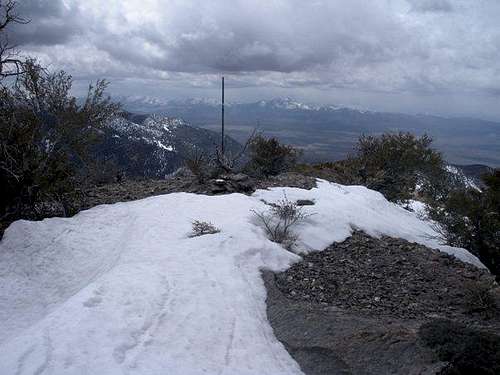
 Summit Cairn and register
See Eric's page on his visit to Wah Wah's HP summit HERE.
Red Tape
The is BLM land so there is no red tape but there were cattle grazing in a pasture area (fenced) on the north side of the road. An old mine camp is passed as you get close to the area where I parked near Pine Grove Pass (I didn't go all the way to the pass. Despite the fence, we still encountered a couple of cattle on the roadway so just be aware that they might be there.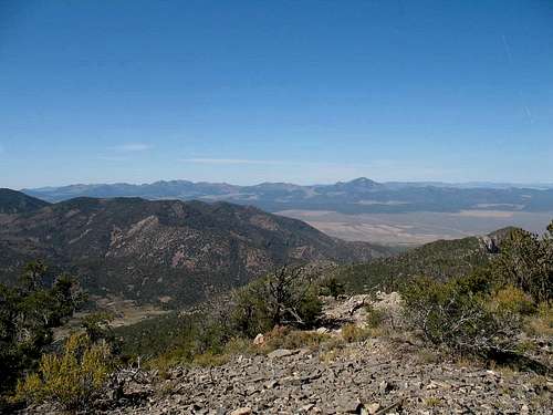
The view westward
Camping
There are plenty of places shown in Mike Kelsey's book where you can camp but as most are on BLM land, finding a camp spot isn't a big problem. BLM land is land you can car camp on although I recommend that you are careful to leave as little impact as you can and not create new fire rings or the like. There are no organized campgrounds in the area but according to Mike Kelsey's book, there are a few campspots indicated on his map (pg.249)My wife and I stayed at the Oak Tree Inn in Milford and found it to be a very nice motel and the price of the room includes a full breakfast. ($80 range)

Weather (Milford)

Trip report and odds and ends
When we left Milford, on what was the first day of autumn, it was still dark.We had stayed at the Oak Tree Inn and had just finished a wonderful breakfast so both my wife and I were ready to go out and visit the isolated Wah Wah Mountain HP located in the southern part of the Wah Wah mountain chain. When we had been to Indian Peak back in May, I knew we'd be coming back to about the same area. My wife doesn't do the hikes with me but she is a great support and we keep in contact by little handy talkies as I go by myself up a mountain. She loves the travel and the areas and is a real history buff and reads up on an area we will be visiting. She had recently read Mike Kelsey's book about Jack Watson and the western desert and was thoroughly amazed that someone would even try to eke a living out in such a lonely area.
We had to dodge some proghorn antelope that were playing in the middle of the highway and had my wife not alerted me to their presence, I might have drove smack into the middle of them. I didn't notice them due to the fact that I was looking up at Wah Wah North and trying to visualize a route up that one from the highway. Before long we passed Wah Wah summit where a road takes off north to a spot where you can park and go from to climb Wah Wah north but we had to zip right on by as we were heading to the southern Wah Wah highpoint. I found the turnoff that heads to the Pine Valley road and was soon hitting the correct turns and turnoffs and heading into the canyon that leads up to Pine Grove Pass. It was much nicer than I thought it would be as a small stream worked its way down the canyon and soon green pastures were seen where cattle could graze. These pastures aren't very wide but they did have a few cattle in them. The road wasn't bad although we did encounter a couple spots where you had to pay attention to some ruts and a couple muddy spots. Overall, the road is relatively easy to drive and didn't really present me with any problems.
After you go past the Pine Grove Mining camp (on the south side of the road), the road deteriorates a bit but is still very manageable. Using my GPS coordinates, I found a spot just off the side of the road where I parked the truck. Using a two way radio of the handy talkie variety, my wife and I stayed in communication as I set on up the slope and headed towards my first waypoint, located about a half mile away. There wasn't a lot of underbrush on this first hill but I did have to zig and zag a bit to find the easiest route. Finally, I topped out on this hill only to see that going further up to the NE would be counterproductive and so I plotted a way that dropped down a bit before I started sidehilling for awhile. Unfortunately, the side hill was loaded with brush and before long I was finding my way into thick growths that would force me to backtrack or zig and zag to make progress. As soon as I got to some tongues of talus, I just started to make my up the rocks as it was easier than the brush. I gained elevation much more rapidly and soon I was able to contour back to the northwest and line up with where the summit was on my GPS. When I hit the ridgeline, it was like hitting a freeway as travel became very easy and finally I had the hard work behind. A small cairn was found at what at what wasn't actually the highest spot and in it was a glass jar register, containing a register book that dated back into the early 90's. Left by Barbara and Gordon (desert peakbaggers know who these two are), it contained a page left by Andy Zdon who had visited the place in 1988. Many very familiar signatures were found in the booklet as well as an Andy Martin map with his name on it. Not many overall considering that the time spanned almost 20 years. The highest spot was a bit beyond where the register was placed and was easy enough to locate and it is worth a extra investment of time to go over to the Wah BM peaklet which is ten feet lower. Since the register and cairn were placed at the view point so be sure to explore the area a bit before heading back down.
My visit at the summit was long enough to get some pictures, explore a bit and eat a snack and head back for where I had left my wife and vehicle. Of course the way back was much easier as I knew the way and I was excited to get this one done and checked off.
Update: In May 2013 Ken Jones hiked up and you can find his trip report and a GPS track HERE
Register pages
The following are just a couple to share:

Geo cache anyone?
Two great geo caches are on or near the mountain. One is one of the oldest in Utah and is called "Wah Wah Stash". People come from all over the world to find this one. The one actually on the mountain itself is called "Wah Wah Wah" cache. It is located well away from the summit and if you are a geo cacher you can find information on it on the geocache.com website. Scoff at geo cachers? You are making a mistake because it is a great and fun hobby to get involved with and finding a geo cache on a remote mountain like this adds to the fun and adventure. The geo cache was placed in 2011 and has been found (before we found it) by only two other parties.The South Wah Wah range
As seen from near highway 21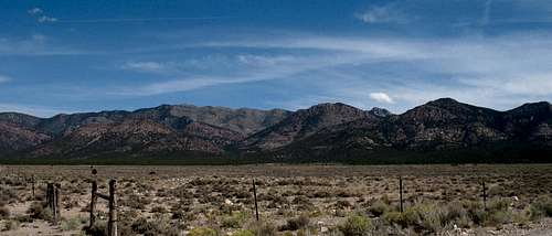
Disclaimer
Hiking, climbing or traveling in this type of country can be inherently dangerous, the above information is provided only as a courtesy. You accept all risk and responsibility for your activities in this area and I recommend that you let others know of your plans and where you will be hiking/climbing prior to heading to this area. Be self sufficient and carry plenty of food, water and shelter in the event of a breakdown. Good quality tires are a necessity on the rough and rocky roads you will encounter as is a vehicle in good condition. Roads may become impassable when wet. Avoid the area during electrical storms and avoid high ridges &exposed areas. Having said all that, have a good trip and please let the author of this page know of changes that you encounter.Please let me know if road conditions or access changes.