
-
 11425 Hits
-
 80.49% Score
-
 12 Votes
|
|
Mountain/Rock |
|---|---|
|
|
44.36170°N / 104.0151°W |
|
|
Lawrence |
|
|
Hiking |
|
|
6096 ft / 1858 m |
|
|
Overview
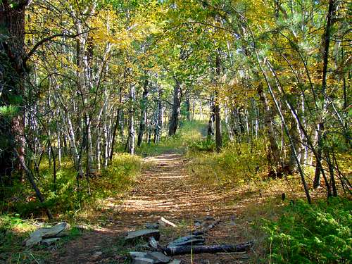 Old Baldy Trail View
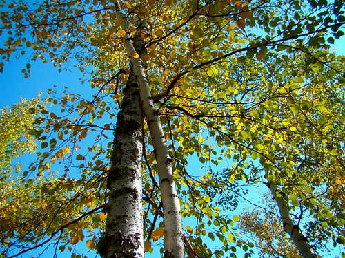
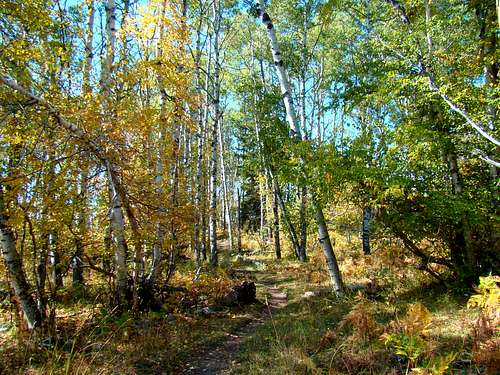
For anyone who loves hiking through groves of quaking aspen, paper birch, spruce and ponderosa pines, the hike to the summit of Old Baldy Mountain in Lawrence County, SD is a great delight. This is especially true in the autumn, when all the fall colors reach their peak. The area around Old Baldy is prime elk country, though whitetail deer are also seen here. It is common to hear the elk bugling in the autumn. The peak sits on public lands on the north side of private lands owned by the Mathews Ranch. The forest is in the Northern Hills Ranger District and is managed by the Black Hills National Forest office in Spearfish (605) 642-4622. Though both are located in the South Dakota Black Hills, this Old Baldy Mountain (6,096) is not to be confused with the Old Baldy Mountain (5,605) situated behind Mount Rushmore in Pennington County. According to Lists of John, Old Baldy Mountain has 240 feet of prominence, making it an unranked summit. Old Baldy is just two miles from the Wyoming state line and has a good view of Cement Ridge, the highest summit in Wyoming’s portion of the Black Hills. There is a clear view to the east from the summit of Old Baldy, and Terry Peak is the easiest mountain to identify.
 Trail View of Mathews Ranch
The Beaver Creek watershed runs to the west and south of Old Baldy Mountain, while the headwaters of Iron Creek are just to the east. There is a small depression in a meadow that is labeled as “Baldy Lake”. However, it is dry most of the time. A small bridge (one of two on the loop trail) crosses at one end. Along the western portion of the loop are several old mineshafts. There are no obvious safety barricades, so the careful hiker will carefully consider the risks associated with deep pits and no rescue services nearby. Also located along the westernmost portion of the loop is Mathews Flag, a small summit approximately 6,130 feet high with a geodetic marker at the high point. There is no trail to that summit, so a short bushwhack and careful map study is necessary to accomplish this.
Getting There
 Autumn Butterfly
 Old Baldy "Lake"
The Old Baldy trailhead is accessed from Tinton Road. If you take Tinton Road (FSR 134) from Spearfish, the distance is 13 miles. Or, if you prefer to travel through beautiful Spearfish Canyon and Little Spearfish Canyon, the distance for that route is around 21 miles. That route requires you to drive 14 miles from Spearfish on Highway 14, turn west at Savoy on Roughlock Falls Road (FSR 222) for 6 miles to Tinton Road, where you will turn right and follow Tinton for 1.1 miles to the trailhead, located on the north side of the road.
Route Information
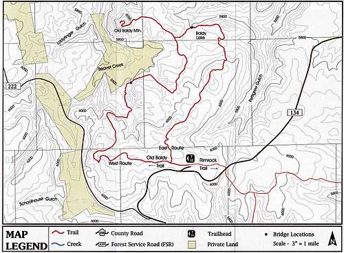 Old Baldy Trail Map, courtesy BHNF
The summit is accessed by a spur trail from the Old Baldy Trail (Black Hills Trail 66). Forest service maps list the loop at 5.7 miles, with the spur being .7 mile in length. However, you will find books and other websites that list different numbers. The forest service further complicates that with trail signs that also contradict their map distances. However, you can probably safely conclude that if you do the entire loop and the spur to the summit, your hiking distance will still be in the 7 to 8 mile range. The trailhead and Old Baldy’s summit are nearly the same altitude, but there is 234 feet drop to the two bridges on the loop. One does not have to hike the trail for very long to realize there is frequent horse traffic on the route, plus stray cattle wandering through the forest and on the trails. Unless you do not mind gumming up your boot treads in the droppings, you will need to watch your footing carefully. Another problem with the horse traffic is encountered in low areas on and along the trail, where water collects and horse hooves churn the dirt into significant mud holes. The forest service does a pretty good job of keeping the trail marked with signs and blazes, plus maintaining damaged stretches of trail. Of course, this is normally essential anywhere there is much horse traffic.
 Trail Info Sign
 Trailhead
 Spur Junction Sign
 West loop sign
Red Tape
No permits or fees are required to hike Old Baldy. Careful observance of Black Hills National Forest Camping Regulations will keep you in the good graces of the forest service, should you choose to camp along the trail somewhere. Be sure to pack out what you pack in.
When to Climb
 Crisp fall day on the Old Baldy Trail
The trail is not cleared in the winter, and can become impassable by mid-winter after the deep snows that are so characteristic of the northern Black Hills. The rest of the time, the trail is accessible. Please note that during and after spring snow melt, as well as after soaking rains, portions of the trail can become very muddy. Despite these things, if you can choose to hike the trail during peak autumn colors, you will be treated to some brilliant displays. For the latest weather forecast and conditions, click on this link: Old Baldy – Spearfish Area Forecast & Conditions South Dakota big game hunting seasons in late fall may also be a concern, so be sure to wear plenty of bright orange if you choose to hike then. For more on the South Dakota hunting seasons, check out this resource:
South Dakota Hunting Season Information:
Maps
 Old Baldy Trail Spur Junction
 Old Baldy Trail Loop Fork
The best maps for the Old Baldy area are the Black Hills National Forest Map and the National Geographic Black Hills North Map. Either one can normally be purchased at any Black Hills forest service office, as well as various tourist information areas. The forest service also provides free trail maps for Trail # 66 in a small box at the trailhead. These small maps have some topographical markings and are drawn to scale. They include features like the two bridges encountered on the loop and the connection to the Rimrock Trail. The trail map also includes a location map and driving instructions, an elevation guide and general information.
Camping & Lodging Information
 Great Place to Camp
There is some limited camping at the trailhead, and the forest service also allows some primitive camping along the trail, though campfires are not allowed. A few miles to the east, along Road 222, the Roughlock Falls Road, you will find several campgrounds. There is more camping and lodging in nearby Spearfish Canyon. Hopefully, you will find the resources below to be helpful:
Northern Hills Ranger District
2014 N. Main Street
Spearfish, SD 57783
Phone: (605) 642-4622