
-
 7952 Hits
-
 81.69% Score
-
 14 Votes
|
|
Mountain/Rock |
|---|---|
|
|
43.93160°N / 103.4795°W |
|
|
Pennington |
|
|
Hiking |
|
|
5856 ft / 1785 m |
|
|
Overview
Public hiking and climbing opportunities are abundant in the east-central Black Hills, with a large concentration of summits in the area between Mount Rushmore and Sheridan Lake. Samelias Peak is in the middle of that area and offers some fun climbing, good photo ops and great views at the summit. According to Lists of John, Samelias Peak has 476 feet of rise, ranking it #71 in the Black Hills for prominence. Many people who climb Samelias Peak include it as part of a multiple-summit outing, including Mount Warner to the northwest and Hardesty Peak to the south.
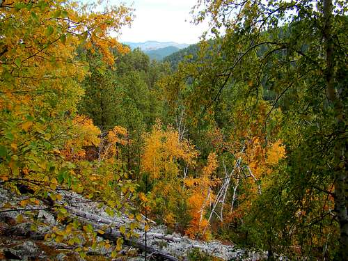 Looking north from the east slope of Samelias Peak
The Centennial Trail bisects this area, providing access to these peaks and others further north. This portion of the trail is reported to be the highest and roughest of the 111-mile route from Wind Cave National Park to Bear Butte State Park. The trail makes use of old 2-track forest service road in places, and single-track pathways over the rest of the route. While the trail takes hikers right to the summit of Mount Warner, it only circles the lower flanks of the northern half of Samelias Peak. So those wishing to climb Samelias will have to choose an off-trail route to the summit. Like most of the Black Hills, ponderosa pine is the dominant tree on Samelias Peak. But, there are also many aspen, some oak and some ash trees as well. Birds are in abundance, with occasional eagles seen soaring far above. Deer are also in abundance, giving a basis for caution during late fall hunting seasons. Visitors to the mountain might also see bighorn sheep, elk, fox, or even a mountain lion. There are mountain goats in the area, but they tend to prefer the area near Mount Rushmore and the Black Elk Wilderness to the south.
 Black Hills Steam Train
One interesting thing that often happens during a hike up Samelias Peak, is hearing the whistles of the 1880 steam train that still runs from Hill City to Keystone along Road C323 two miles to the south. While the old steam train is hard to spot from the summit, it is easy to see Highway 16 immediately to the southwest. Also readily visible from the summit is the north part of Hill City, Black Elk Peak to the south (with Elkhorn Mountain visible in front of Black Elk), Hardesty Peak to the south-southeast and Mount Warner to the northeast. Photo at the right shows the old Black Hills 1880 Steam Train that can be heard by hikers in the area between Black Elk Peak and Samelias Peak.
Getting There
The best route options are accessed from Highway 16, east of Hill City. The Samelias Peak Trailhead on the Centennial Trail is approximately 6 miles from downtown Hill City, on the north side of the highway. If you are traveling west on Highway 16 from Rapid City, the Samelias Trailhead is about 20 miles.
Route Options
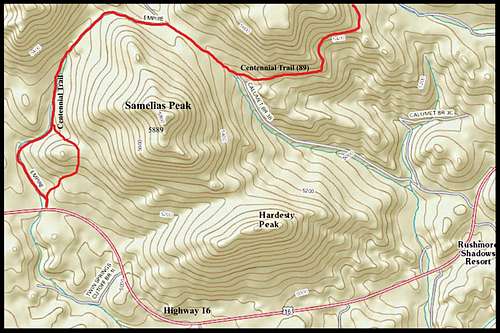 Samelias Peak Map
With the “one-two” punch of pine beetle kill plus deadfall from Winter Storm Atlas in 2013, off-trail hiking in the Black Hills has generally become noticeably more difficult. But for whatever reason, Samelias Peak does not have anywhere near the level of deadfall many of the other peaks have. Another thing that makes an off-trail hike on Samelias easier, are the boulder fields on various places on the mountain. Despite those natural reference points, having a GPS and/or compass is probably a good idea, especially on a cloudy day. The gain in elevation from the trailhead to the summit is nearly 800 feet. Short Route: Straight-line distance wise, bushwhacking up to the summit from the Samelias Trailhead might be the shortest way up, being perhaps about .7 mile one-way. That route will take you through the thickest forest and miss most of the boulder fields. If choosing this route, it is probably best to actually take the Centennial Trail from the Samelias Trailhead, rather than the old 2-track trail to the west (obviously used much more). These two eventually join further north, but will generally confuse anyone who bushwhacks east from the 2-track trail when they cross the much-fainter single-track Centennial Trail a little further east. Longer Route: An easier to find route (and much more scenic in the fall) would be to take the Centennial Trail (trail # 89) around the north side of the mountain and to the east-northeast side (about 1 to 1.3 miles) and bushwhack up from that area, using the boulder fields as your reference point. The shortest off-trail route pretty much crosses the largest of the boulder fields. Counting both the trail and off-trail portions of this route, the hike is about 2 miles one-way. Another factor in favor of this route is convenience if you wish to also summit Mount Warner.
Red Tape
There are no fees or permits needed. To avoid trouble, one only has to comply with Black Hills National Forest Regulations. Camping is allowed in the forest, as per regulations. They are particularly strict about campfires, so be sure you are in compliance. Please remember to pack out what you bring in.
When to Climb
 A Samelias Boulder Field
Spring, summer, and fall are all good times to hike. Winter hikes will depend on snow depth. Of course, summer lightning and winter blizzards will likely mean your hike will have to be re-scheduled. For more on the latest weather in the Samelias Peak area, click on this link:
Hill City – Samelias Peak Area Weather
Big-game hunting seasons in the fall will warrant wearing a healthy amount of bright orange. You can learn more about South Dakota hunting seasons at this link:
South Dakota Hunting Season Information
Camping
 Samelias View Southwest
The national forest service has campgrounds in the area, plus the nearby towns of Hill City and Keystone have chambers of commerce that maintain up-to-date listings of campgrounds and lodging. To learn more, click on any of the links below:
Black Hills National Forest Camping
Hill City Chamber of Commerce Camping & Lodging
Keystone Chamber of Commerce Camping & Lodging
Forest Service Contact Information

The Samelias Peak area is managed by the Black Hills National Forest Service. To contact them, click on the link below, or you may call them or write them.
Black Hills National Forest Service Office
1019 North 5th Street
Custer, SD 57730
(605) 673-9200
Maps
Some really helpful maps for the area include the Black Hills National Forest map, available for purchase at forest service offices. The Black Hills North map, published by National Geographic is also quite useful. And, for the latest on open forest service roads, you can get a free copy of the Motor Vehicle Use Map for the Black Hills, also at forest service offices.