|
|
Area/Range |
|---|---|
|
|
44.11100°N / 73.90835°W |
|
|
Hiking, Mountaineering, Trad Climbing, Toprope, Ice Climbing, Scrambling |
|
|
Spring, Summer, Fall, Winter |
|
|
4000 ft / 1219 m |
|
|
Introduction & Layout
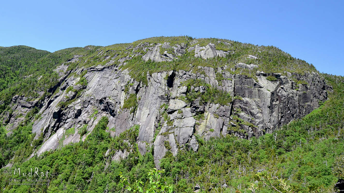
Panther Gorge lies between Mt. Marcy on the west and Mt. Haystack on the east. The elevation differential between Marcy's summit and the gorge is approximately 1,950 feet. This area hosts the most remote backcountry traditional climbing in the Adirondacks. It's an exercise in tenacity to get to the base of the routes. Once there, the rock quality is excellent with a view that's awe-inspiring. Signing up to climb in the gorge is about experiencing a full day out in the backcountry with all the bells and whistles—high mileage, bushwhacking over rugged terrain, navigational challenges and of course the ice route. For the effort you’ll climb in one ofthe most rugged and majestic High Peak locations free of road noise and crowds. A typical day-trip takes from 13 to 19 hours and accumulates over 4,000 feet of elevation gain over 16-18 miles. A lean-to and campsites are available at Slant Rock to the north of the Gorge.
Though the lowest hanging fruit in the Gorge has been done, route development is ongoing. There are currently 71 routes as of July 4, 2020 including 19 ice climbing routes. Rock climbing routes vary from 5.3 to .11d YDS with most falling between 5.7 and 5.9. Ice routes range between NEI2 and NEI5/M5 with the majority of climbed routes in the WI3-4 range.
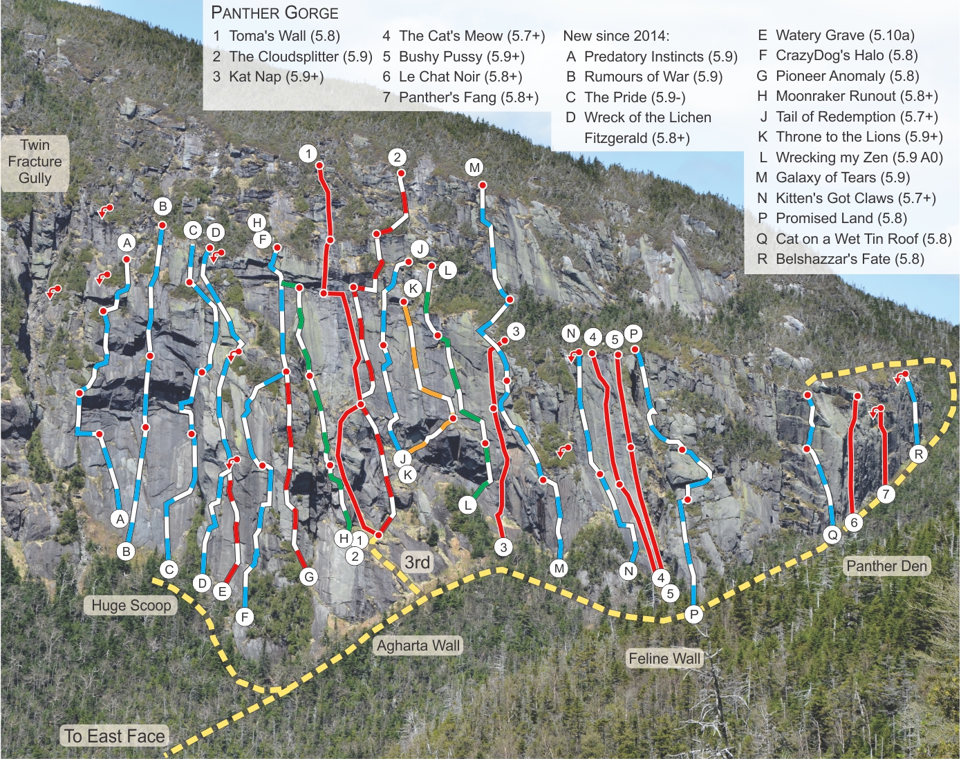
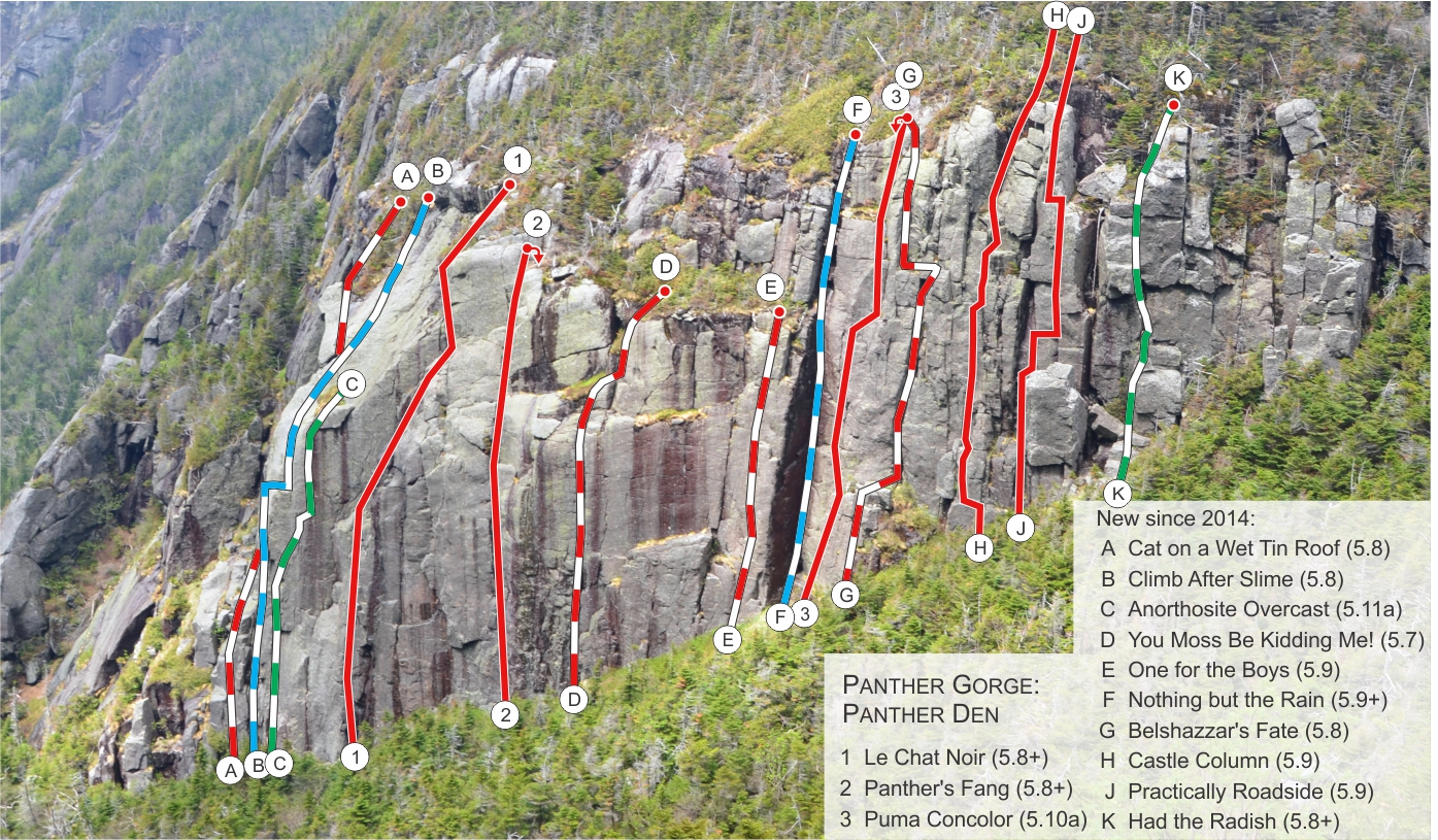
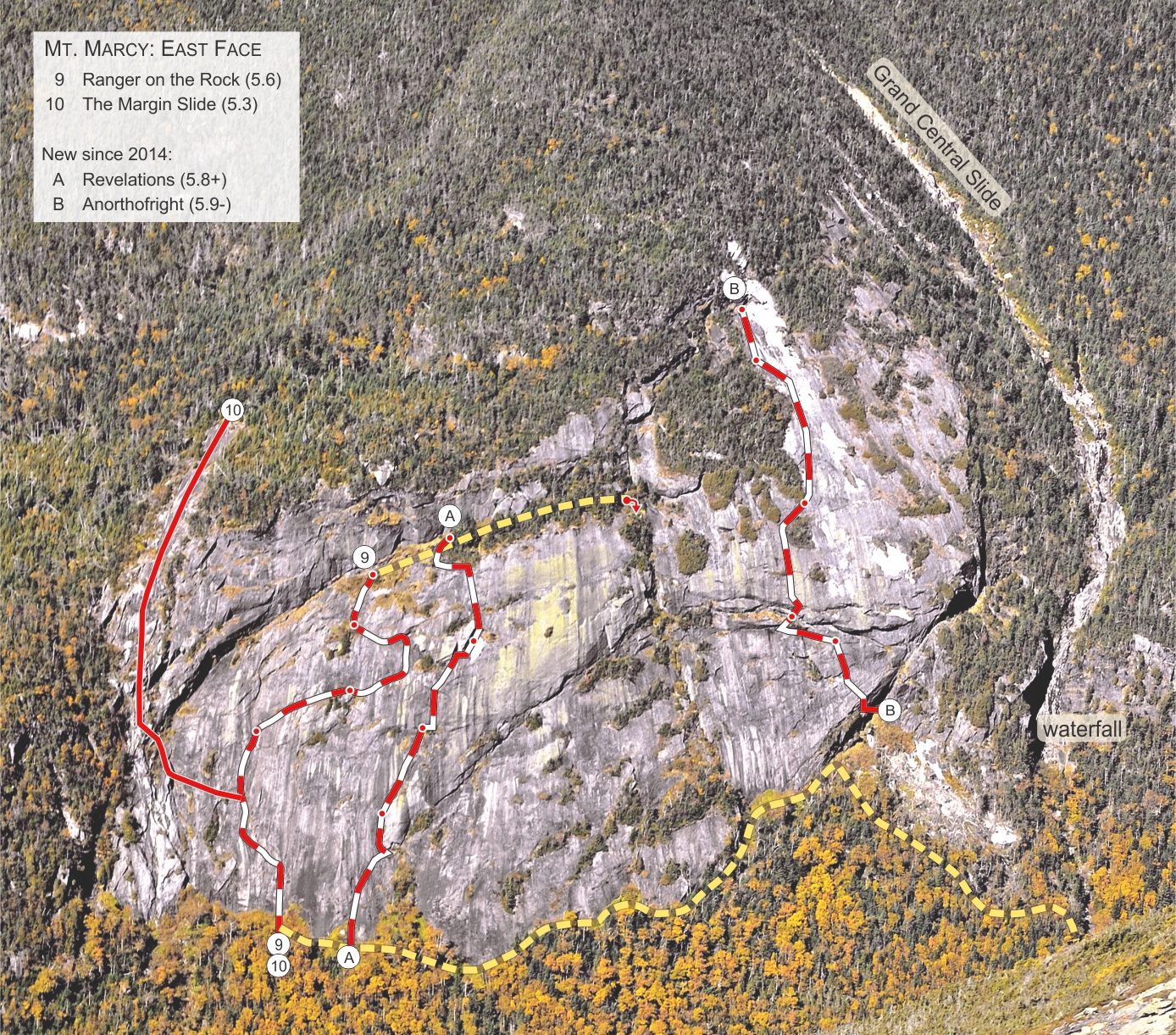
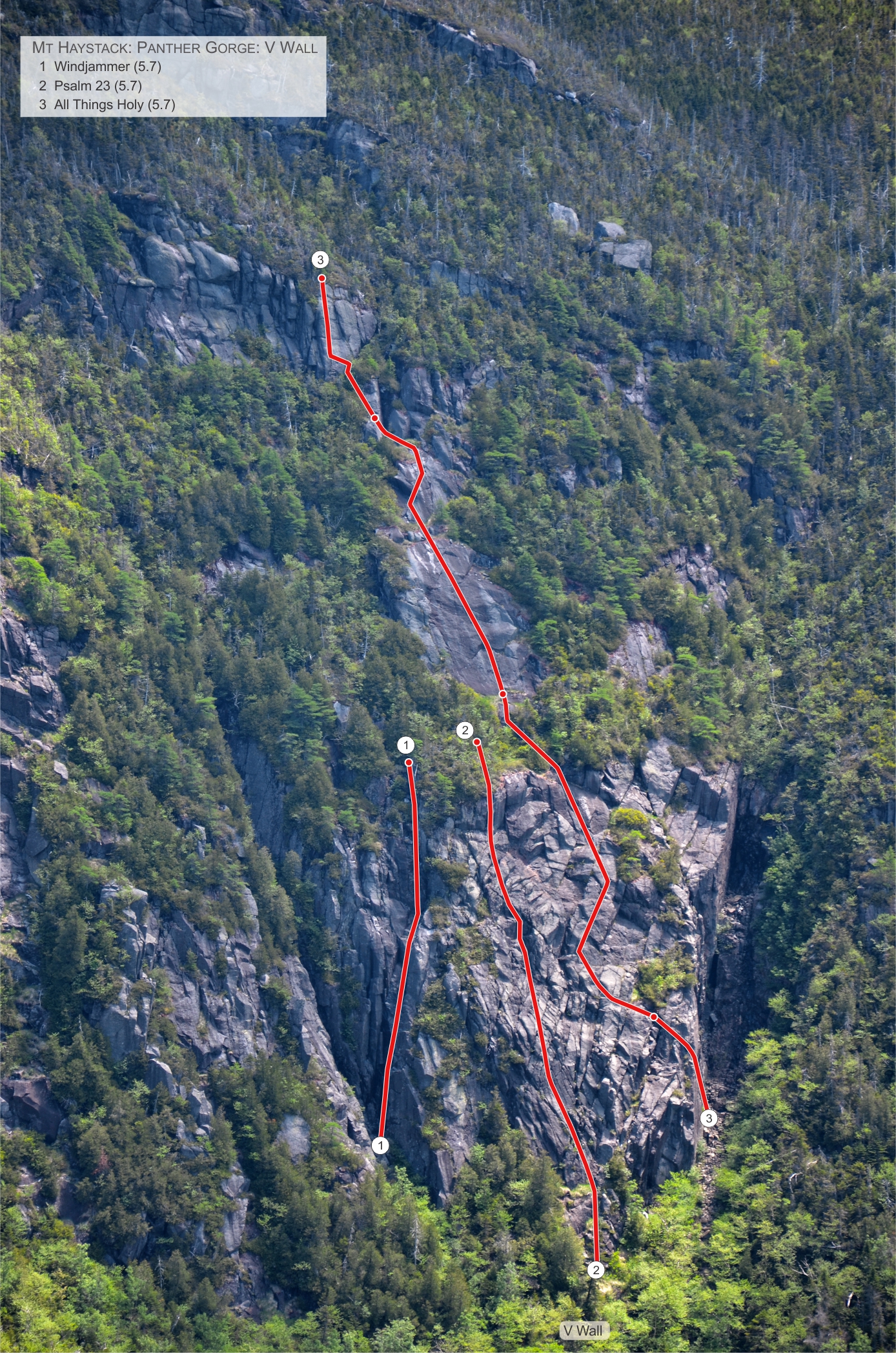
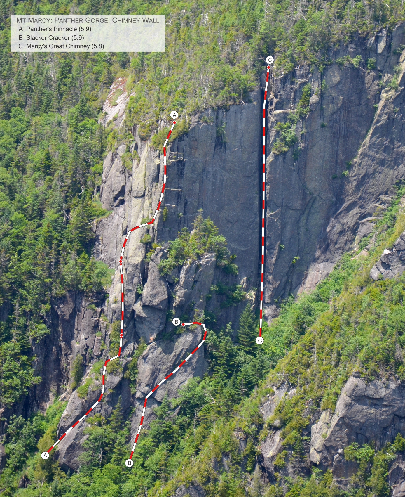
From north to south on the Marcy side: The five named walls on this side of the gorge are the Panther Den, the Feline Wall, the Agharta Wall, the Huge Scoop (opened in 2015) and the Chimney Wall. On a side note, the name Agharta was inspired by the Miles Davis Agharta album after Christian Fracchia and Charlie Dickens made the first ascent of the Agharta (not Agartha) ice route in 1999--the Gorge's first ice climbing route. Several other cliffs and slide site between the Huge Scoop and Grand Central Slide (the easiest scramble in the area once above the cliffs). Immediately south lies the East Face, a quarter mile wide technical slab. On its southern border lies the Margin Slide. From north to south on the Haystack side: Marcy's walls hold the most technical and aesthetic routes, but Mt. Haystack also offers some unique climbing opportunities. The first route lies on a pillar roughly 525 feet south of the Phelps Trail, the first of its kind to be documented in the area. Next is the Ramp Wall, named for the obvious left rising ramp. This area has 7 routes ranging from 5.5 to 5.11d. The next wall in the line, No Man's Land, includes the obvious large slab and a broken cliff to the immediate south. A "V" shaped wall south of the Ramp Wall (set between a basaltic dike and gully) holds several ice and rock climbing routes while a set of conjoined technical slides lies approximately 1/4 mile to the south. The terrain in the middle of the Gorge hosts a series of beaver ponds, blowdown fields, talus fields below almost every cliff (including Mt. Marcy Cavern) and a variety of drainage streams that join with Marcy Brook (Champlain watershed).
Getting There
From the Garden Trailhead in Keene Valley, follow the Phelps Trail past Johns Brook Lodge and Slant Rock to the State Range Trail junction (7.8 miles). Begin bushwhacking a few hundred feet beyond the junction at the top of the pass where the Phelps Trail veers right. Ski mountaineers may wish to approach from the Adirondack Loj via the Van Hoevenberg trail before descending the Phelps Trail to the col. In either case descend south from the Marcy/Haystack col and stay to the right and above the drainage to avoid extensive talus and ledges.
You’ll reach the Panther Den, the first wall on Marcy, after about 20 minutes of hard bushwhacking (.2 miles). A 300' long glade along the cliff’s base leads to a faint herdpath on the left. The path stays moderately close to the cliffs for about 250 feet until reaching the Feline Wall which is characterized by steep slab with a deep gully to its right. The now intermittent path curves to west over the next 300 feet to the Agharta Wall marked by an obvious cliff below a vast slab. From Agharta continue downhill roughly 125 feet then make a hard right around a buttress. Bushwhack 200 feet up a drainage stream to the Huge Scoop—the last of Marcy’s north-end climbing walls.This is characterized by an obvious rectangular scoop with a gully to its left.A series of smaller cliffs, gullies and slides sit between the Huge Scoop and Marcy’s East Face ¼ mile to the south-southwest.
Exit along the approach if you plan to rappel down a route. Bushwhack north to the Phelps Trail if you plan to exit from the top. Bushwhacking from the top is more complex for routes south of the Huge Scoop.
External Links
Articles
- "A Climbing Experience in Panther Gorge." Huther, Nolan
- "Panther Gorge: The Remote Adirondack Moderate Mecca You’ve Never Heard Of." Wechsler, Alan. Nov. 2017. Climbing.
- "Panther Gorge Rocks." Wechsler, Alan. Sept/Oct Adirondack Explorer. 58-61.
- "The Wild Side-Rock Climbing on Haystack and Flash Flood at Slant Rock". MacKenzie, Kevin. 2016. Adirondack Outdoors. 25-27.
- "New Highs: Backcountry Climbing in Panther Gorge." MacKenzie, Kevin. Adirondack Life 2016 Annual Guide to the Great Outdoors. 10-13. Print.
Climbing Resources
- Marcy - Overview of Panther Den, Feline, Agharta, Huge Scoop
- Marcy - Panther Den Close-up
- Marcy - East Face
- Haystack Overview
- Haystack - Pillar & Ramp Wall Area
- Haystack South End
- Haystack - No Man's Land
- Haystack - V Wall
- Chimney Wall
Complete Route History
History that includes FA information, graphs, locations, length and grade of each route in excel format. This sheet is updated after each known FA, so if you add a new route please PM MudRat.
Route Descriptions
Each new route with mosaic photos (aerial with inset details) may be found at Mountain Project & Adirondack Rock.Google Earth KMZ file
Locations and brief descriptions of the cliffs and other notable climbing features.
Mosaic Collection
High resolution distance photos or aerials with inset detail photos and route line may be displayed or downloaded. This also includes about 70 slides, but you may display by filename and scroll to the technical lines. Each route begins with panther_gorge. The naming convention generally follows this layout: “panther_gorge_AREA (Marcy or Haystack)_ASPECT_ROUTE NAME.jpg”.Special Thanks
Thanks to all the bushwhacking and climbing partners (a unique brotherhood) who have made the adventures a success over the years—Adam Crofoot, Bill Schneider, Anthony Seidita, Mark Lowell, Greg Kadlecik, Scott van Laer, Allison Rooney, Hunter Lombardi, Justin Thalheimer, Dan Plumley, Devin Farkas, Nolan Huther, Alan Wechsler, Dustin Ulrich, Loren Swears, John Pikus, Jaryn DeShane, Doug Ferguson, Walker Wolf Bockley, Matt Dobbs, Jace Mullen, Steven St. Pierre, Ken Hebb, Aaron Courain, Katie Vannicola, Emily Schwartz, Harold Sutton! Special thanks to Don Mellor and Jim Lawyer for their support and interest!