Introduction
Route:
South Meadows to Marcy, Bushwhack east down Marcy’s main drainage bowl to Grand Central Slide-top, Cross Panther Gorge/Marcy Brook to Bushwhack Haystack via Western Face, Follow Range Trail to Rooster Comb and Keene Valley.
Partner: Greg “Krummholz” Kadlecik
Weather: 50’s-70’s, sunny with rain late afternoon and evening
Mileage/Vertical Ascent: Need to check but about 20 miles / 19.5-9100 with bushwhack into Panther Gorge (Bushwhack=1.4 miles/1400 vertical gain)
Nutrition: 6 liters water, 1 emergen-c pack, 2 egel packs, 1 mac/cheese dinner, 1 omlet, 3 loaves banana bread, 2 powerbars, many starburst
Benchmarks:
-Wake-up: 4:00 a.m.,
-Begin at South Meadows:4:45
-Marcy Summit: 8:30 (30 minute break and route checking)
-Begin Bushwhack to Grand Central (east face) Slide: 9:00
-Grand Central Slide Top: 9:50
-Panther Gorge Bottom: 10:50
-Haystack Summit after Bushwhack up Western Side to Summit Direct: 1:25 p.m.+1450’
-Basin: 3:30
-Saddleback: 4:20
-Gothics: 5:35
-Armstrong: 6:15
-Upper Wolfjaw: 6:50
-Lower WJ: 8:00
-Hedgehog: 9:00ish (walked by in semi-catatonic stupor)
-Rooster Comb: 10:15
-Exit In Keene Valley: 11:45
FULL PICTURE SET:
![Descent from Marcy]() Descent down Marcy via eastern face 7 Grand Central Slide.
Descent down Marcy via eastern face 7 Grand Central Slide.![Bushwhack up Haystack]() Bushwhack route up Haystack's western face.
Bushwhack route up Haystack's western face.
Greg and I bushwhacked into the north end of Panther Gorge last month for a bushwhacking/slide foray. During the trek, we spotted a possible slide or drainage on Haystack’s western flank on a weakness between the cliffs below Little Haystack and Haystack proper. For years, I’ve wanted to explore the west face area a bit more closely. Thus we talked about a subsequent climb up Haystack. We emailed over the following week about a subsequent dayhike and the conversation went something like this:
Kevin: “Hey, I’ve got an idea…What about bushwhacking down Marcy’s drainage to the eastern face slide, traversing Panther Gorge and ascending that serpentine break in the trees to Haystack’s summit?”
Greg: “Great! Let’s do it.”
…a couple days later.
Kevin: ”Hey, you know that idea about traversing Panther Gorge?”
Greg: “Yup. Really looking forward to that.”
Kevin: “Well…what about if we do that and add a Great Range Traverse (through Rooster Comb) after the bushwhack?”
Greg: “Great! I’m in! I’ve never done a full Great Range Traverse before either!”
…so it began.
--------------
I’d never done the Great Range Traverse from Marcy to Rooster Comb. WalksWithBlackflies, nartreb, Puma concolor and I did a Keene Valley to Garden loop in 2006, however
(see here). It nearly 'killed' me and took 21 hours. I’m no speed-demon, but I can keep momentum going to finish a lengthy dayhike. Combining a traverse and Panther Gorge bushwhack was a wildcard since bushwhacks are so much more demanding than trail hiking. Crawling, pushing trees, climbing ledges, extricating oneself from sodholes, getting cut up and navigation all take more energy. Putting 4.5 hours of ‘whacking’ together with the trail mileage and vertical ascent nearing 10,000 total feet (with the descent into the gorge) all put the outcome as less than certain in my mind. Both of us needed a good challenge to counterbalance recent life stressors, however.
I planned on the conservative side and assessed our completion time between 20-24 hours (leaning toward 24) as I’m not the fastest hiker over a long day.
Hike to Marcy and Grand Central Slide
4:45 a.m. found us walking and telling each other that we needed to hold back on the pace for the long haul. Neither of us had hiked in a month. I was a little concerned about weather reports from the prior day; showers and a supposed late night thunderstorm. I though we’d be hiking until early morning and didn’t want to be on an exposed peak with a foray of lightening about the area. Thankfully, we were greeted with a cloudless day that began with temperatures in the 50’s F…perfect, especially after a sweltering week in the 90’s. I don’t remember a thing about the walk to Marcy Dam, we were simply there 50 minutes after beginning.
![In Marcy s Eastern Face Cripplebrush]() In between ridges on Marcy's eastern face.
In between ridges on Marcy's eastern face.
Time continued to pass quickly as more talk and some early morning humor found us at Indian Pass Brook adding a liter of water to our respective supply for the bushwhack into the gorge where we could refill again. Arriving at Marcy in full sun at 8:30, we found the path of least resistance from the trail into the drainage bowl of the eastern face (between the main eastern ridge and northern ridge). It was located about 200 vertical feet below and north of the summit on a heading about 125 degrees. The top of the drainage is convex, forming a bowl. I alloted 1.5 hours to bushwhack through the cripplebrush to reach the slide top since it took Mark Lowell and I 2 hours to reach the summit from slide top via the main ridge in 2009.
A small meadow led quickly into the thick of it. Various intermediate humps and outcrops decorated the landscape. Haystack, now shadowed, loomed in the distance and seemed far away across a sea of spruce. In the beautiful grasses and early summer blooms, I first found a drybag with map and notepad, infiltrated by water and moldy…darn. A few hundred feet later, I found a candy wrapper and tucked it into my bag.
The spruce was only slightly difficult to navigate, by my standards. We had gravity on our side to help push through the forest. Most disconcerting was the sudden unseen drop underfoot from a hidden ledge or sodhole. Sodholes were the largest problem after the first hillock. The solution was to trek south of east to get out of the minor drainage. View were astounding all the while as the steep ridges pressed from the sides. We were descending quickly and looking for the upper portion of the slide where it gently curves toward the eastern ridge. At no time did it appear, but we knew we were in the correct drainage on a direct heading to it. 45 minutes into the descent, we found another area of rotting trees and sodholes…another bloody drainage. I tracked slightly south through the, now taller spruce, and saw a dramatic swath of rubble mere feet away through the woods…Grand Central Slide! I looked at my watch; we’d made the descent in 50 short minutes.
Slide Descent
The sun was bright and the blackflies thick and biting on the slide. The combination of sunblock and 2 types of bugspray didn’t deter them. I moved on the slide and broke a piece of rubble loose. “Rock!!”…Greg jumped aside. I suggested we descent side by side until reaching slab. Afterward, the descent went smoothy. The views were amazing, especially of our next portion…the ascent up Haystack.
![Greg Kadlecik at Grand Central Slide Bottom]() Greg at the bottom of Grand Central Slide's precipitous lip overlooking Panther Gorge.
Greg at the bottom of Grand Central Slide's precipitous lip overlooking Panther Gorge.
The last time I was on this slide was in 2009 in the fog and drizzle. This sunlit descent was a delightful change. Divots, dikes, intrusions and rippling ridges of stone made the slab easy to descend. Sunlight enhanced the nuances and the meager trickle of water brought out the colors. The bottom of the slab prior to the cliff is home to a diagonal ridge of anorthosite that redirects the water south across the face. I saw the feature from high above. Once at the diagonal, we descended another 10’ ledge and approached the edge of the cliff. The southern ledge tracks nearly east (perpendicular form the lip) and overhangs. The northern ledge runs north-south. This intersection seemed to draw me forward toward the maw, a dizzying feeling.
Below, the forest of Panther Gorge spread out like a carpet, the hardwoods and softwoods in groupings of light and dark green. I knew the area to be a loosely knit network and very pleasant to traverse. The western face of Haystack sat beyond with shear cliffs, chutes, technical slides and a very tempting ramp; a weakness in the face and our target. We just had to navigate down and around Marcy’s cliff, the route being just to our south.
Some new activity on the face (since 2009) confused me. It wasn’t quite how I remembered. I stayed relatively close overhanging ledge on the south and descended via a series of precarious ledges. 100’ further south lay the ramp that I’d previously used as an ascent. So we descended the ledges carefully and using much energy…energy we’d need later to climb the subsequent 9 mountains. Once below in the drainage, we refilled our hydration bladders with enough water for the ascent up Haystack to the Hay/Basin col.
Note: As mentioned, I climbed this in 2009 so I knew how to circumvent the cliffs. It's easy to get cliffed out, so I wouldn't descend this without first finding the route before-hand.
Haystack: Western Face Bushwhack
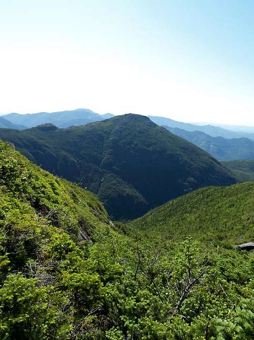
Our walk through Panther Gorge was serene. Open forest, soft mosses and the tranquil Marcy Brook lulled our senses. It was the calm before the storm. Our heading across the gorge was 96 degrees magnetic, ideally a bearing that would lead to the drainage slab up higher. We found a convenient drainage and following seemingly on the correct heading. The ascent got increasingly harder as we exited the now deeply recessed drainage, its walls long grown in and overtaken by the forest. Atop the wall, was a view of the valley I’ve never seen. Little Haystack’s cliffs loomed just to the north and the full panorama of Marcy’s eastern cliffs answered our gaze from the opposite side of the gorge. Minor drainages from Marcy’s upper forest drained into chutes in the cliff, one after another. Shadows decorated the face enunciating the lines.
![Cliffs of Panther Gorge]() Cliffs on Marcy's eastern face in Panther Gorge taken from about 200' up Haystack's western face.
Cliffs on Marcy's eastern face in Panther Gorge taken from about 200' up Haystack's western face.
Continuing, we found a ledge and circumvented it to the north, a crucial error. Our relative position to the Grand Central slide was correct while low on Haystack’s flank. Ascent drew us slightly to the north, but enough to foil our attempt to locate the minor (possible) slide/drainage on its initial run. Our TARGET track led to a series of outcrops which in turn led directly to the summit. Another drainage hugged the south of Little Haystack’s cliffs. Our errant track was between the two. 400’ up the face, higher than the ledge of Grand Central, we reassessed. We were too far north and needed to contour directly south. 10 mintues later found us at the top 1/3 of what can only be described as a grown in drainage with a few meager open patches of rock, red with algae and slick with moss. Oh well, not every plan works perfectly!
A couple hundred feet higher was our first rounded outcrop. At least we were in line to climb that and its successors on a heading of roughly 130 degrees. Hopefully the open rock would minimize the swim through the krumholz. The base of most cliffs often harbors a corridor of openness, a break in the cripplebrush. Ice and rockfalls kill the trees at the base and grass and smaller plants populate the duff in the summer. I hoped this held true on Haystack.
Each successive knob of rock was a work of art, often 50 or so feet high. Crags and weaknesses in the face made climbing relatively easy. When it wasn’t, we traversed around to find a weakness or crevasse. These climbs formed the highlight of Haystack’s western face. Some of the boulders were overhanging in their formation, a tempting refuge for a freak storm. Others were like pieces of an interlocking puzzle. The climb went quickly while rock-hopping from protrusion to protrusion. 1:30 found us on the summit and re-nourishing; relishing the view of our 1.5 mile bushwhack and laughing about it’s relative brutality and shortcomings. I told Greg it was still easier than Haystack’s eastern face. I suppose it would have been easier on him if he hadn’t worn shorts as well J
It took us 8 hours and 45 minutes to reach this point of the day, some 2 summits attained of 10. Our next goal was to finish the Great Range Traverse. We didn’t reassess or talk of failure, we just looked at each other and said, “Here we go!”. Within that phrase, was the inherent context that we were absolutely going to complete this project.
Basin, Saddleback, Gothics, Armstrong, Upper/Lower Wolfjaw, Hedgehog & Rooster Comb
Basin/Saddleback/Gothics
We refilled our water bladders at Haystack brook. I’d gone through 4 liters and was dry. I added 4 more liters for the rest of the trek. Our progress can best be described as ‘slow and steady wins the race.’ The showers forecast for the day began as we reached the cables on Gothics at 5:00 p.m. The light rains blew a cool air across and the effects of evaporative cooling were appreciated. A dinner of mac & cheese set well as we took a 10 minute respite on Gothics summit.
Armstrong/Upper & Lower Wolfjaw
We trekked quickly over Armstrong and UWJ, gaining each summit in less than 35 minutes a piece. Lower Wolfjaw found us beginning to feel the cumulative strain of the day, especially the bushwhack. Greg’s knee was painful and I was cramping pretty severely which last for 4 hours. I’m not sure of the reason as my food and water seemed in check. The soft ridge-top trail was a welcome change underfoot.
Hedgehog & Rooster Comb
Darkness settled on us as we descended Hedgehog. We used headlamps for the ascent due to the thick canopy of branches. Hedgehog’s descent was slow and painful as my knee had nearly locked with pain in my ACL. Pure will-power compelled us up Rooster Comb. We were within a breath of the last summit and the rain was still relatively mild though steady. Our conversations were humorously mono-syllabic, almost grunts. My mind kept jumping to friends that can run this range combined with others nearby…jeez.. how can they go such distances, far beyond what we did? I’d chalk it up to old age, but MG is older than I so that excuse is out the window J.
Atop Rooster Comb, a gentle wind blew as the rain took a break. Headlamps could be seen descending Hedgehog, likely of three people we passed while descending Armstrong.
Exit
Monosyllabic talk morphed to quiet solitude for much of the remaining 2 miles out as we focused upon placing one foot in front of the other and keeping our knees in check. I also pondered my caloric deficit of the day, likely about 8000 shy. Less than ¼ mile from the car, I followed a boardwalk to the left over a pond, led us in a circle around it and started an ascent back toward Rooster Comb. The irony that we successfully traversed Panther Gorge some 10 hours earlier, but got lost around a frog pond within a stone’s throw of the car was NOT lost on me. We retraced our steps, found our error and arrived at the car at 11:45 after an hour of hiking in a much heavier, though still pleasant, rain. Another Sunday walk in the park!


Comments
Post a Comment