
|
|
Mountain/Rock |
|---|---|
|
|
37.99800°N / 107.508°W |
|
|
Hinsdale |
|
|
Hiking, Mountaineering, Scrambling, Skiing |
|
|
Spring, Summer, Fall, Winter |
|
|
13321 ft / 4060 m |
|
|
Overview
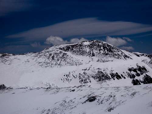
Located in the San Juan Mountains of Southwestern Colorado, in the Uncompaghre National Forest is Sunshine Mountain. While scaling this mountain is not challenging, what it does offer are some phenominal views of the surrounding popular peaks like Handies Peak and Wetterhorn Peak (both Fourteeners). Sunshine Mountain is a ranked 13er and falls on the Colorado highest list at #375.
Being sandwiched between Matterhorn Creek (5 miles to the southwest) and the very popular American Basin (Handies Peak, Alpine Loop, extensive wildflowers etc.), this mountain doesn't see many visitors even though it is very apparent while driving lower Henson Creek Road.
For peak baggers, Sunshine carries 1,101' of prominance (rise), is located in the Handies Peak quadrangle and just inside Hinsdale County. It's line parent is "Animas Forks Mountain". Because of lower cliffs and heavily forested slopes, the higher up Henson Creek one drives, the mountain becomes more difficult to see. It lordes over Boulder Gulch to the south and the North Fork of Henson Creek to the north. Like mentioned, it is an easy mountain to hike that promises solitude and few if any people. It is easily comboed with two other peaks in the area: Dolly Varden Mountain and Point 13,093.
Getting There
To access Sunshine Mountain, one's starting destination should realistically be the small San Juan town of Lake City. Lake City is roughly 54 miles south from Gunnison. Head west on CO.149 out of Gunnison to the Blue Mesa Reservoir. At the junction for Co 50, turn left (south), cross the bridge and proceed 45.5 miles south to the town of Lake City. The later part of this drive is exceedingly beautiful, especially in the autumn.
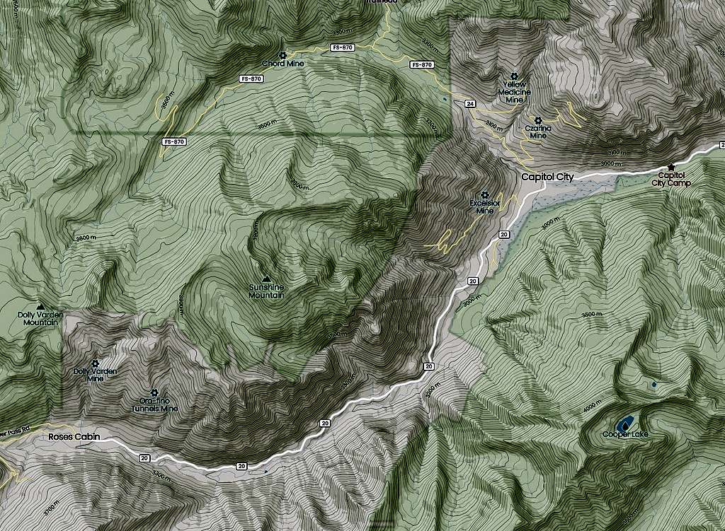
From downtown Lake City, follow 2nd avenue west for approximately two blocks. At the intersection of Bluff Street, turn left (south) and follow Hinsdale County Road 20 (also known as Henson Creek Road) up Henson Creek. This is a beautiful drive in its own right. The dirt road can be rough at times and a bit exposed as the canyon cuts deep to the south (left) but it is still passable for passenger cars to the trailhead for this mountain.
Continue to drive west passing Nellie Creek (trailhead for Uncompahgre Peak) at roughly 5.3 miles.
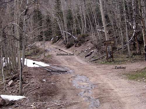
After 9.2 miles, the turnoff (right side) for Matterhorn Creek will be your exit. There is an old ghost town at this fork called Capitol City but sadly, few buildings exist.
Drive up the rough but mild 4x4 road (Forest Service Road #870). The Matterhorn Creek Trailhead (10,400') should come after 11.3 miles or so. There is parking located here as are places to camp.
North Henson Creek Road continues to the left for an additional 2.2 miles to the roads terminus at a wide cul-de-sac. The elevation here is about 11,590', definately a high camp!
This is the end of your 4-wheel journey and the start of your two-foot trek. From here on out, all treking is off-piste. There are no regular trails leading anywhere into the upper basin or to the southern ridge. If you're lucky, you might come across elk trail or deer trail. Solitude will be a guaranteed companion on this leg of the journey.
The coordinates for the end of this road (useful in winter) are approximately: 38°00'36"N, -107°31'28"W
To give a better idea of where one wants to be in relation to the mountain and to bypass the vulgarities of the cliffbands earlier on,
use the following coordinates as a point of reference to achieve the upper plateau/basin: 38°00'03"N, -107°31'56"W
Weather
As with the seasons, summers are generally warm to hot in the day and cool down rapidly with the nightfall. Due to the highly convulated nature of the San Juan Mountains, weather can form on its own down here regardless of the area forecast.
Beware of the typical thunderstorms that form in the summer and fall and know that winters here can be brutal and cold. There are many passes that close regularily in the San Juans and Wolf Creek Ski Area routinely leads the skiing industry in snowfall.
Make sure your departure times are early enough to better guarantee your chances of a successful summit!
Since camping and weather often enough go hand-in-hand, remember as cold air sinks, this forces the warmer air up higher, usually trapping it in between the colder air near the bottom of the canyon and the colder air in the upper layers of the atmosphere. Since warmer air is lighter and thus less 'viscous', it stays sandwhiched in between. Not until the sun rises, warming the upper layers of the atmosphere is this pocket of warmer air actually able to move. Once this happens, updrafts are created. This ofcourse, simply adds to the fueling of summertime thunderstorms.
Camping
As is posted, camping is not permitted along Henson Creek Road. I believe this is due mostly to safety reasons and the chances of destruction to sensitive areas. Plus, as much traffic as this road sees in the popular summer months, it's doubtful one would have a positive camping expereience anyway. There is however, a small area suitable for camping at the Nellie Creek turn-off. There is also room to camp at the end of North Henson Creek Road in a cul-de-sac of sorts.
Once you pass the turn for Matterhorn Creek, places do become available for camping as the road widens. Practice LNT techniques by utilizing pre-existing fire rings and leave rocks and logs scattered as opposed to ordereing them. There are no fees.
Mining/History

The mountains surrounding Lake City and the city itself are rife with mines and mining stories. Many of the local peaks, mountains and passes got their names from the early miners who came here in search of riches.
Lake City for instance, is named for Lake San Cristobal, Colorados second largest natural lake. It was created by a natural landslide that resulted in damning the North Fork of the Gunnison River roughly 800 years ago. The resulting slide (and nearby mine) was christened 'Slumgullion' by the miners to the earths resemblance of slumgullion stew that the miners and prospectors ate (brownish-orange with larger boulders in the mix). The nearby pass takes its name from this fact as well.
Of the numerous mines, debris fields, ghost towns & reconnaissance pits, the Ute-Ulay mine, located up Henson Creek Road is the largest and unquestionably, most colorful in terms of history and noriety.
In 1845, the republic of Texas was no longer an independent nation. It sided with and became part of the United States. However, most of the decisions to join the USA came from poor finances as a result of costs incurred while fighting Mexico. Most of the lands & territory that Texas controlled or owned were sold to the Unites States to pay those costs. Present day Hinsdale County in Colorado was part of that exchange.
Prosperctors and fur trappers began to move into the area once things settled down in 1860. Even though the situation was somewhat settled with Mexico, once gold and silver was discovered, it was decided that something had to be done about the Ute Indians in the area.
In the middle part of 1873, a treaty was signed. A short while later, the Ute-Ulay mine was established on Henson Creek. As more people moved into the area, Lake City was established in 1875. By the way, the native Ute pronounced Chief Ouray's name as Ulay; hence the name of the mine.
As the mine provided healthy amounts of ore, Lake City grew. By November 1876, it boasted 1,000 people. Of course, other mines sprouted up also like the: Moro, Yellow Medicine, Hidden Treasure, Pride of America and Dolly Varden to name but a few. In 1877, Otto Mears built a toll road connecting Lake City to Silverton and Ouray, what would eventually become known as the 'Million Dollar Highway,' between SIlverton & Ouray anyway.
In 1878, the small town of Henson located at the mine was established. Most of the inhabitants were miners from the Ute-Ulay or Hidden Treasure. Even though the town was never incorporated, it boasted 300 people, a barbershop, three saloons, a school and on-again, off-again post office. But all was not to last.
Over the next several decades, multiple factors came into play that threatened to close the Ute-Ulay and empty Henson. One was the tendancy of Henson Creek to completely freeze. This was the power supply for the mines. So all work stopped when this happened. In 1893, the US Government demonitized silver. While this definitely put a noose around the area mines and businesses, it wasn't a death blow in that, other ores were mined: zinc, gold, copper. But like with any mine, ore production ebbed and flowed. And so ownership of the mine changed hands frequently.
At the turn of the century, under the forth owner (Auric Mining Company) out of Leadville, a strike erupted over pay and working conditions. Unfortuately this was only a glitch to the company and proved to be more detrimental to the miners and immigrants.
People slowly moved out of Henson and Lake City or left the area all together. Henson eventually became a ghost town as the few people who did remain, couldn't keep things going. Especially during the often brutal winters. Interest in the Ute-Ulay and Hidden Treasure mines wanned. Combine that with extremely poor management policies (some outright racist), unreliable ore output and a slow contamination of the ground, all activities up Henson Creek stopped.
In 2009, the mine and townsite underwent a $1.2 million clean up and reclamation. Today, the complex is listed on the National Register of Historic Places and is considered one of Colorado's best-preserved historic mining communities.
For more information, check out the following links.
- "Little Rome" and the 1899 strike
- The townsite of Henson
- Capitol City History
- Ute-Ulay & Hidden Treasure Mines
The Alfred Packer Story (cannibalism)

Of all the campfire stories, tall tales, amazing scenarios and lore surrounding the history of Colorado, no chronicle is complete without going into the tragedy of Alfred Packer and Colorados only case of cannibalism.
A self-professed mountain guide and early prospector, Packer was leading a small group of somewhat inexperienced miners from Provo, Utah into Colorado through the San Juan Mountains. Being rather destitute, without money or supplies, Packer kept his worth among the miners as a guide leading them to the gold mines of Breckenridge. Even though Packer wasn't entirely a con-man (like "Soapy" Smith), being a rogue without direction, he knew not to let a good opportunity pass him by. Hence him taking up with the miners un Utah. So who was the man known as, 'The Colorado Cannibal?'
Alfred Packer was born in 1842 in Pennsylvania, After being a cobbler for a short time, the Civil War came calling. Packer enlisted in 1862 in Company F, 16th US Infantry fighting on the side of the Union. It's not known if Packer was an abolitionist or harbored feelings of anti-slavery or if he signed up 'for a paycheck' without regard to reason. However, due to seizures (epilepsy), he was given a medical discharge in December. Eventually, Packer found his way out west working as a guide in the Utah and Colorado territories.
While in the military and indeed, in his everyday interactions with people, he was oft described as a quarrelsome person, petty, miserly and just overall, an unpleasant person.
In the middle half of 1873, a group of 20 individuals left Salt Lake City bound for Breckenridge, Colorado to try their hand in the newly discovered gold mines. During a brief stop in Provo, these 20 people met up with Alfred Packer. As previously mentioned, not having much in the way of equipment or money, they deemed him worthy enough to help lead the way into the San Juan Mountains and through to Breckenridge.
Later that year, the winter proved harsh, cold and snowier than usual. After finding shelter and solace at Chief Ouray's winter camp near present day Delta, Colorado, against the advice of Chief Ouray, five of the men (Frank Miller, Shannon Bell, Isreal Swan, James Humphrey, George Noon) including Packer set out for the Lake Fork in February 1874.
Hopefully lost, out of food and starving, according to Packer, Bell came after Packer with a hatchet. Packer ended up killing Shannon Bell. "Finding" the cold bodies of his companions with one 'sliced up' with pieces missing, Packer resorted to eating the bodies vs. starve to death.
Sixty-six days later, only Packer emerged from the mountains, looking remarkably fit. Packer arrived at the Los Pinos Indian Agency 35-40 miles northwest of Saguache, Colorado. This is when he told his tale.
Basically that he had become seperated and lived off rabbits and rose buds fo the duration of the winter. But when questioned why he had so much money and the other mens posessions on him, he came clean stating: four of the men died from starvation and the elements and that, after eating some of the other men, Bell became crazed and attacked Packer, he turned the tables and killed Shannon Bell in self-defense. Packer did not deny eating Bell or some of the other men. However, the five skeletons were discovered together at the same camp and not strung out along the make-shift trail that Packer mentioned. Packer was charged with a single count of murder upon Isabel Swan whose remains showed apparent signs of struggle. Packer was taken to the jail in Saguache but later that night, he escaped.
He was found nine years later in Wyoming living under the name of John Schwartze. He was transported back to Lake City for trial. He was found guilty and sentanced to 40 years at the Territorial Prision in Canon City. After 15 years, he was parolled in 1901.
Alfred Packer died April 24th, 1907 of either a stroke or liver ailments (conflicting reports). He has always maintained his innocence. His dying words, according to the Littleton Independent, were, "I am not guilty of the charge."
Because of his military affiliations and service, the military paid for the funeral. He is buried in the Littleton Cemetary, southwest corner of lot 65.
External Links & Miscellaneous
- Henson Creek
- Colorado Preservation home- Ute-Ulay Mine
- 14ers.com- Sunshine Mountain
- 14ers.com- trip report
- Point 13,093'
- Lake City, Colorado
- Lake City Brewing and Southern Vittles Restaurants
In the area...
A short list of some neighborhood peaks/mountains
| Peak Name | Elevation | Colorado Rank | Peak Name | Elevation | Colorado Rank |
| Uncompahgre Peak | 14,309 | #6 | Sunshine Mountain | 13,321 | #321 |
| Handies Peak | 14,048 | #40 | El Punto Peak | 13,300 | #394 |
| Wetterhorn Peak | 14,015 | #49 | Point 13,300 C | 13,300 | #399 |
| Jones Peak | 13,860 | #78 | Wildhorse Peak | 13,266 | #427 |
| Niagra Peak | 13,807 | #101 | Bonita Peak | 13,286 | #409 |
| "American Peak" | 13,806 | #102 | Broken Hill | 13,256 | #436 |
| Silver Mountain A | 13,714 | #139 | Precipice Peak | 13,144 | #529 |
| Coxcomb Peak | 13,656 | #171 | Cow Benchmark | 13,111 | #558 |
| Redcliff Mountain | 13,642 | #175 | Point 13,093 | 13,093 | #574 |
| Matterhorn Peak | 13,590 | #193 | Blackwall Mountain | 13,073 | #593 |
| "Heisshorn" | 13,411 | #312 | Point 13,051 | 13,051 | #608 |
| Cinnamon Mountain | 13,328 | #370 | Dolly Varden Mount. | 12,932 | #694 |