
-
 13150 Hits
-
 89.39% Score
-
 29 Votes
|
|
Mountain/Rock |
|---|---|
|
|
37.83210°N / 107.9688°W |
|
|
San Miguel&Dolores |
|
|
Hiking, Mountaineering, Scrambling |
|
|
Spring, Summer, Fall, Winter |
|
|
12703 ft / 3872 m |
|
|
Overview
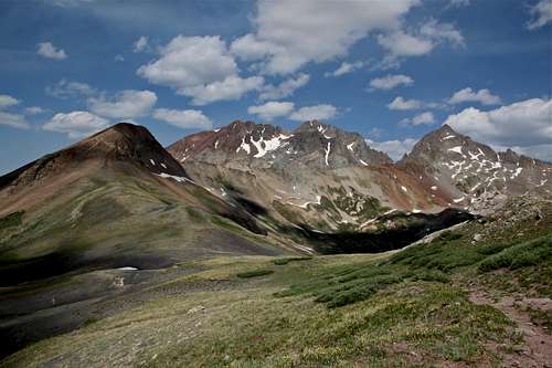
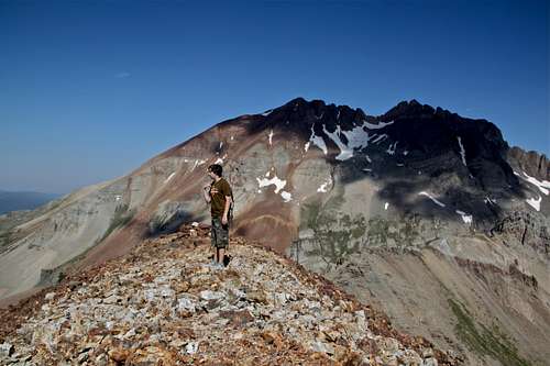
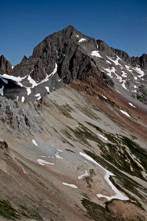
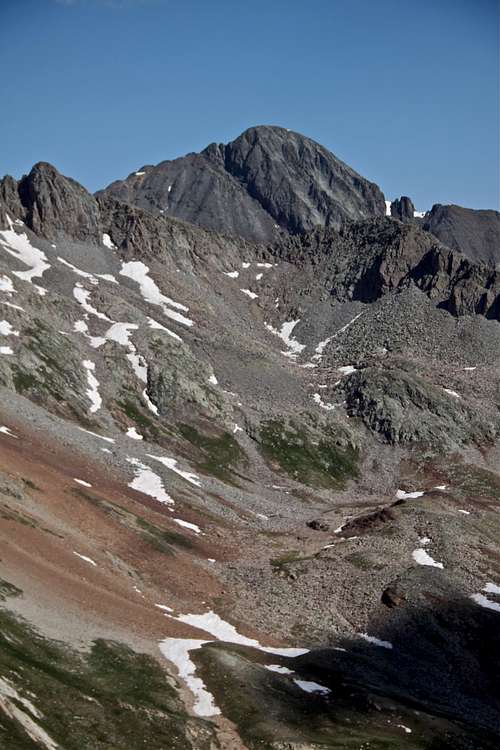
Cross Mountain with Mount Wilson and Gladstone Peak
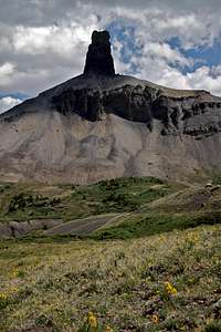
Lizard Head
There are several mountains with the name Cross Mountain. This one is located in the San Juan Mountains in the Lizard Head Wilderness. The hike offers excellent views of famed Lizard Head and Wilson group of high peaks. Cross Mountain is located in Lizard Head Wilderness.
The mountain is featured in Best Summit Hikes in Colorado, and the author James Dziezynski describes its unique position amongst the crowds of 14ers and high 13ers.
"Atop its modest summit, I felt like a traveler who had come to see the advice of a sagacious council. Cross is dwarfed by peaks from the Wilson group to the west; the effect of gazing at these enormous mountains is mesmerizing. Across the way is Lizard Head, indisputably the most difficult summit to ascend of any mountain higher than 13,000 feet in Colorado. This crumbling, 400-foot, sheer monolith is the enduring throat of an extinct volcano." Fewer people have reached its summit than have climbed Mount Everest.
Cross Mountain has a different feeling than any mountain I have ever climbed. It's a fun scramble in its own right, and the views from the top are incredible. If I had a say, I would rename it "the Altar" for the ways it pays homage to nearby high peaks."
Parent Lineage:
Line Parent: Gladstone Peak
Proximate Parent: Lizard Head
Getting There

Cross Mountain Trailhead

Cross Mountain Trail
Cross Mountain Trailhead is 2.0 miles south of Lizard Head Pass off Colorado Route 145; this is roughly 15 miles south of Telluride. The large parking area is on the west side of the road and is marked by signs for Cross Mountain Trail at the turnoff. If you are coming from the south, the trailhead turnoff is approximately 12 miles north on Route 145 from the town of Rico.
Any vehicle can reach the Cross Mountain Trailhead. The road is paved the entire way (though the parking lot is not).
Route description
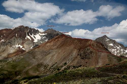
Illustration of hike/scramble as seen from the approach trail
Start at the Cross Mountain Trailhead and head west on the Cross Mountain Trail (#637). Lizard Head stands like a granite lighthouse in the distance, and you can even see Cross Mountain to the left of Lizard Head. There is a split at 0.4 miles for Groundhog Stock Trail (what a name!). Avoid this trail and stay the course on the Cross Mountain Trail. After this intersection, the class 1 trail is obvious. Hiking into the shadows of the pine forest is a treat and a provides a nice shade on hot days.
At 1.8 miles you pass the official wilderness boundary into the Lizard Head Wilderness.
At 3.2 miles you come to a clearing in timberline, and mountains come back to view. Cross Mountain is the reddish "hill" off to the west. At this point, you are at the pedestal of Lizard Head and at the junction of the Cross Mountain Trail and the Lizard Head Trail. Go left (west) on the Cross Mountain Trail to the western saddle between Lizard Head and Cross.
3.6 miles: At the saddle, get off the trail and head west onto the northeast ridge of Cross Mountain. Stay on the ridge spine while it is still grassy. When the slope morphs to rock, hike onto the south side of the mountain, below the ridge. A faint trail less out to a brief class 2+ scramble where the northeast and east ridge intersect.
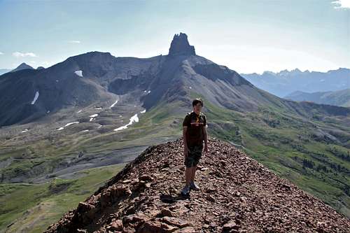
4.0 miles: You are on the ridge. This ridge walk turn out to be quite a thrill. It has just enough exposure to keep your adrenaline glands on standby. Follow it to tis western terminus.
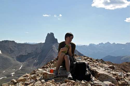
4.3 miles: Cross Mountain Summit! Behold the nightly peaks to the west (from left to right): El Diente, Mount Wilson, Gladstone Peak, and Wilson Peak. From here, Lizard Head looks less saurian and more like the rotten fang of an aged predator. There is a large cairn with summit registry on the summit (out entry was only 2nd entry in the 2012).
Descent: Return the same way.
Round Trip Distance: 8.6 miles
Hiking Time: ~ 4-6 hrs
Class: 2+
Start Elevation: 10,040 feet
Highest Elevation: 12,703 feet
Best Time: June-September
Summit views
 Summit ridge is 0.3 miles long Summit ridge is 0.3 miles long | 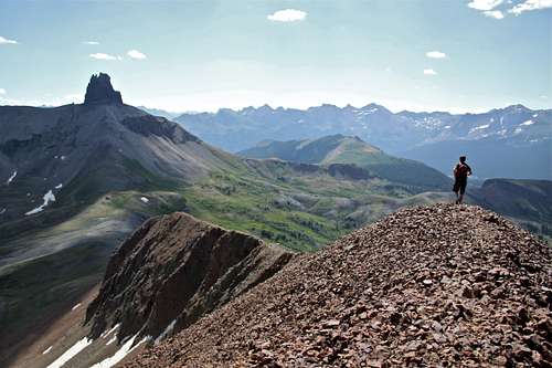 Descending summit ridge Descending summit ridge |
Red Tape
There are no fees to hike or camp in this area. Please note that camping in the parking area is illegal. You must pass the wilderness boundary to legally camp in the area.Just south of Lizard Head Pass are dozens of good primitive campsites on the east side of the road. These unmarked areas can be found off many dirt roads to the east a few miles after the pass.
hgrapid - Jun 25, 2012 12:57 am - Voted 10/10
Looks great, but you mislabeled the StateAt the top, it is listed "California, United States, North America". Otherwise, a wonderful page.
Liba Kopeckova - Jun 25, 2012 8:54 am - Hasn't voted
Re: Looks great, but you mislabeled the Statethanks, I was just scrawling down, and Cali and Colo are right next to each other.