
|
|
Mountain/Rock |
|---|---|
|
|
33.63920°N / 111.5869°W |
|
|
Maricopa |
|
|
Hiking |
|
|
Winter |
|
|
2523 ft / 769 m |
|
|
Overview
Adams Mesa and Adams Benchmark are two prominent summits located northeast of the Phoenix metro area. They are easily accessed off the Beeline Highway (State Route 87) from the Sycamore Creek Trailhead. It’s about 10 miles northeast of the town of Fountain Hills.
The two summits themselves are separated by less than half a mile. Hiking both of them requires getting off-trail. There is a long approach road that leads to the base of both summits, but from there you need to bushwhack. During the winter months, bushwhacking isn’t an issue, as long as you go in cooler temperatures.
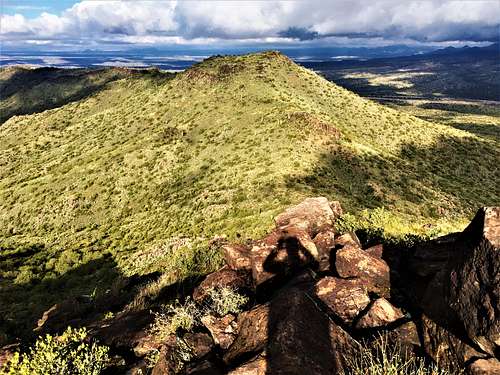
The summits are ideally situated in a location where many nearby mountains can be viewed. This makes for a great destination if you don’t want to get far out of town and want to bag a couple summits. The area has a lots of ATVs, dirt bikes, and target shooters. So, you need to be aware of them on the roads. Few, if any of them, actually hike up to the summits. While the terrain is open enough for bushwhacking to be safe, there is still cholla and other cacti on the mountainside that give armchair hikers pause.
The Adams Peaks are best hiked between November and March. Avoid hiking above 70 degrees which is snake weather, since crux of the hike is off-trail.
Getting There
From State Route 87, drive past the Shea/Fountain Hills junction for about 10 miles. Take a right on the Bush Highway. Take a left and go to the Sycamore Creek Trailhead.
Take the dirt road for about 2/3rds of a mile and there is a large road on the left. Drive just past it and park on the left. This is perfect for 2WD, and that is accessible at pretty much all times unless there is a lot of rain.
Route
Take the large road on the left off the main road, which heads west. Continue for 1 ½ miles and avoid any major side roads. Just stay on this road at winds around with only minor ups and downs.
At 1 ½ miles, you have a choice on which route to take. You can descend a road on the right and follow it down where you can approach both peaks from the saddle. Or, you can keep going for another four-tenths of a mile until you are under Adams Mesa. I recommend a loop where you turn right and go down the road on the east (right) side of the mountains and descend down Adams Mesa.
For this loop, take the road on the right and continue as it winds downhill. It becomes less of a road, and more of a sandy wash. After about a mile and a quarter, you’ll be right under the saddle. It is about ½ a mile and 400’ above you. Try to stay on the hillside and avoid the washes that cut into the hillside. The area is generally open enough to avoid cactus. Once at the saddle, it is 320’ up to Adams Benchmark on the right. Hike up in about three-tenths of a mile.
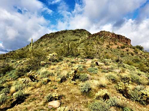
Hike back down to the saddle and head steeply up to Adams Mesa. It is also about three-tenths of a mile, gaining almost 330’. Stay on the ridge to the left. It does get pretty steep, but this is the most solid way up. Once on the summit of Adams Mesa, descend along the right side of Pt. 2453. There is cactus and brush, but nothing unmanageable. It is a little over half a mile from the summit of Adams Mesa back to the road.
If hiking this loop, the total hiking distance is about 6 ¾ miles total gaining about 1,400’ in total with the ups and downs.
Red Tape
The summits are in Tonto National Forest. There is no red tape.
External Links
Thank you to Scott Surgent for providing information on these summits. His website and trip report is here: http://www.surgent.net/highpoints/az/range/adamsmesa.html