
|
|
Mountain/Rock |
|---|---|
|
|
33.25330°N / 111.2539°W |
|
|
Pinal |
|
|
Hiking |
|
|
Spring, Fall, Winter |
|
|
3016 ft / 919 m |
|
|
Overview
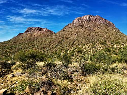
Dromedary Peak is an overlooked mountain located south of the Superstition Range. It isn’t part of the Superstition Range itself, rather it stands as a camel hump dome along US Highway 60. It isn’t unlike Picketpost Mountain less than 6 miles to the east. However, it is a lot easier due to less elevation gain and less hiking distance.
Access is relatively easy. There are two starting points on either side of the mountain right off of US Highway 60. The peak is on Arizona State lands and if wanting to be 100% in accordance with rules and regulations, it is best to have a State Lands Permit. More information in the Red Tape section.
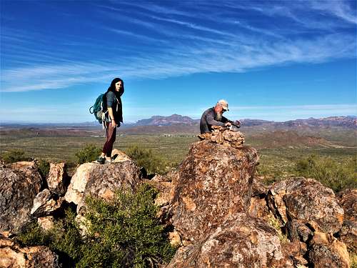
Dromedary Peak has a prominence of 596’, although the mountain seems more significant when hiking up and down the slopes. From the summit, views are tremendous. Weavers Needle and the Superstition Mountains are in view to the north, with many other mountains in view to the south and the west.
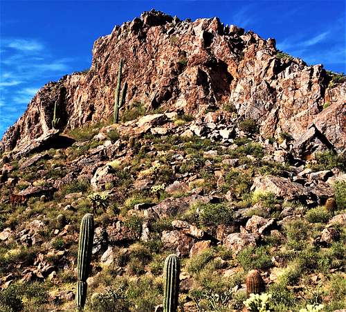
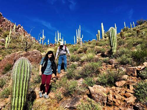
If expecting a trail all the way to the summit, you’ll be disappointed. There is no trail. However, routes up the peak are relatively easy to follow, and the terrain is not too dense. Cactus and brush are easy enough to avoid.
You can hike up both summits. The east summit is 3,016’. The west summit is ~2,800’. It isn’t fully defined exactly how high the west summit actually is, but the prominence is at most 150’.
Dromedary Peak is best hiked between November and March. Avoid hiking above 70 degrees which is snake weather, since the majority of the hike is off-trail and they may be encountered.
Getting There
There are two entrances. The eastern entrance is the main route, and the shortest route. If coming from the west from the Phoenix/Mesa area it is about 5 miles past the junction with Highway 79 (the Pinal Pioneer Parkway, which goes down towards Tucson to the Catalina Mountains).
It is easy to miss. There is a median and a left turn lane, although the entrance is on the right. There is a gate that you need to open and then close. There is a parking area to the left just a tenth of a mile up the road. The road is dirt, but any car can make it to the parking area.
Alternatively, there is a slightly longer route on another dirt road; ideal for approaching via the back side. To reach this route, drive less than 4 miles from the 79 junction. Turn right on Mineral Mine Road. It is a little more conspicious than the northern entrance, but keep your eyes open.
Turn right on this road and drive for a little over a mile until you reach a road on the left. Get on this road and immediately park at a wide parking area on the left.
Route
Dromedary Peak is best reached by hiking up to the saddle between the two summits. This goes for both the front and back side routes.
Northern starting point
For the short route, you can hike up either side, but it is recommended you go up the north side (front side). You can easily go down the back side for a loop hike, which is really pretty.
Across from the parking area is a trail. Take the trail for a quarter mile or so until you can cut over to a small plateau which is fairly open and not too brushy. There are a lot of cattle grazing along the trail and around the entire mountain.
Cut up to the saddle, which from the base requires about 425’ of elevation gain. There isn’t a path, but it is pretty easy to follow as there are many animal trails created by the cattle.
Once at the saddle, it is less than a quarter mile up to Dromedary Peak, gaining about 340’. You can also head up to the rockier west summit.
On the return, if descending the back side, it is pretty easy to follow. Stay generally left as you descend and then cut to the road on the left. You cannot see the road while descending, but if you go far enough to the left, you will catch it. On the way back to the parking area, make sure to stay left at the major junctions.
Depending on how far left you cut on the descent, the hike is likely less than 3 ½ miles round trip if just hiking Dromedary Peak. You can also just hike up and down the north side route. It is about 1.2 miles up the north side from the parking area gaining about 840’.
Southern starting point
For the slightly longer route off Mineral Mine Road, hike a half mile up the road until you see a wash. Take a left and follow for another half a mile until you are under the saddle. Hike up about 450’ to the saddle and go up either summit.
Here too you can go down the opposite side for a loop. In this case, head down the north side (front side), and once at the low point take a left. You will likely head into a wide trail in about ¾ of a mile. Take it back to Mineral Mine Road. Take a left and hike a third of a mile back to the parking area.
Via this route, it is less than 1 ¾ miles to the summit. The whole hike is just under 4 miles.
Red Tape
Dromedary Peak is on Arizona State Lands. While not generally enforced, in order to comply with rules and regulations, you can order an annual permit for $15 at https://land.az.gov/applications-permits. The permit provides access to many other locations on State Lands. This is valuable, since most areas on Arizona State Lands aren’t labeled as Arizona State Lands, so you may be on Arizona State Lands and not even know it!
If entering from the northern entrance, please make sure to close the gate after you enter and after you leave. There’s plenty of cattle roaming the mountain, and nobody wants those cattle to roam onto US Highway 60.