|
|
Mountain/Rock |
|---|---|
|
|
35.81041°N / 52.05548°E |
|
|
Mountaineering |
|
|
Summer |
|
|
11207 ft / 3416 m |
|
|
Overview
Click for Introduction to the Central Alborz Mountains.Click to see a Map of the Dobrar Ridgeline.
Note: My GPS measured an elevation of 3440 m. The 3416 m figure is per the Iranian 1:50 000 Map.
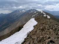
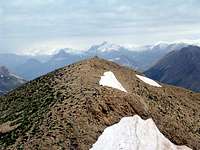
 Southeast Face
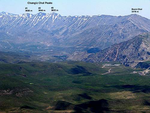 North Face
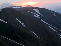 Bazm Chal at Sunset
Dobrar (Ghareh Dagh) Ridgeline is an impressive 52 Km long mountain chain that forms a continuous wall in the southeastern portion of the Central Alborz Mountains of northern Iran. This ridgeline gives rise to more than 20 named peaks and many other unnamed high points. The elevations of 5 of these peaks exceed 4000 m. The highest of these peaks is the 4072 m summit of West Dobrar Peak. The ridgeline starts near the Emamzadeh Hashem Pass on Haraz (Tehran-Amol) Road and heads east to end near the village of Seh Band on Firooz Kooh (Tehran-Sari) Road.
Bazm Chal is the western-most peak of the ridgeline and is the lowest of the named peaks. It rises directly above the Haraz Road and can be used as an access route to reach the top of the ridgeline. After ascending to the summit of Bazm Chal, most climbers follow the ridge-top east to reach the other peaks of the Dobrar Ridgeline. Traversing the entire ridgeline, depending on the climber’s stamina and skills, generally takes a little more than a week.
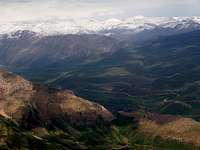
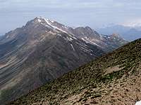
The western slopes of Bazm Chal drop steeply into a tight valley that forms the headwaters of the Haraz River. The northern slopes of Bazm Chal go down to reach the junction of Haraz & Lasem Rivers. To the southeast, Bazm Chal is connected to a number of rounded hill-like high points (some of which have been given names such as Mian Rood and Lasem) before connecting to the 3622 m peak known as Changiz Chal #3. The southern slopes of Bazm Chal provide the best access route to its summit.
From the summit of Bazm Chal, the best view is that of the 5610 m giant cone of Mt. Damavand to the north. Traffic noise from the Haraz Road can unfortunately be heard half way up the slopes of Bazm Chal.
Views From the Summit of Bazm Chal: