
|
|
Mountain/Rock |
|---|---|
|
|
36.03430°N / 51.92220°E |
|
|
14232 ft / 4338 m |
|
|
Mountain Conditions
Overview
Click for Introduction to the Central Alborz MountainsClick for a detailed map of the Central Alborz Mountains.
Click for a map of Dokhaharan Massif.
"Do" means "Two"
"Khahar" means "Sister"
Dokhaharan=Two Sisters


NAME ALERT: Many maps use the name Chapakro in reference to these peaks. In this discussion, Chapakro will be the 4260 m peak to the east of Dokhaharan. The reason for this confusion is not apparent to me since the names are self explanatory. Dokhaharan means Two Sisters and clearly refers to the twin summits while Chapakroo mean Crooked Face. The reason for this name becomes obvious once you see the 4260 m peak to the east of the Dokhaharan Peaks.
The Middle Wall of the Central Alborz (see "Intro to Central Alborz" link above) refers to an 80 Km long area that starts with the 5671 m Mt. Damavand to west of Haraz Valley and stretches west to near the Kandovan Pass at the junction of the Chalus & Karaj valleys. This area contains approximately 45 peaks higher than 4000 m. Some of these peaks aggregate on the eastern part of the area near the Haraz Valley. The twin summits of the Dokhaharan Peaks are the tallest peaks in this group.
The Iranian 1:50 000 map gives an elevation of 4338 m for West Dokhaharan and contour lines of 4300-4320 m for East Dokhaharan (my GPS/altimeter measured the elevation of the east peak at 14135 ft/4308 m).
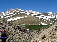
Dokhaharan and its neighbors sit in a true alpine paradise in a rugged and remote part of the Central Alborz Mountains a very long day's hike from the nearest village (and much longer from other trailheads). The guardian of this little piece of paradise is the towering volcanic cone of Mt. Damavand which often dominates the view to the east.
The northern slopes of Dokhaharan drop steeply to around 3800 m and then continue much more gently to reach the bottom of the Sesang River Valley (3500-3600 m). When we visited the area in mid June, these slopes were still, for the most part, covered by a thick blanket of snow. Seasonal alpine lakes can be found in the upper portions of the Sesang Valley. The southern slopes of Dokhaharan drop steeply to around 3400 m at the bottom of the Deev Asiyab River Valley. To the east, Dokhaharan are connected to the 4260 m Chapakro Peak and to the west, they connect to the 4178 m Takhte Khers Peak.
Dokhaharan are usually climbed along with some of their neighbors, in a multi-day hiking program. Below you will find pictures and a brief description of what you will encounter on your way. Much more detail can be found on the "Lehra Saddle to East Summit" Route Page.
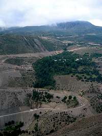
From Tehran, you will drive the Haraz Rd past Mt. Damavand and onto a side road that goes up the Nomarestagh River to the Village of Nomar (2150 m).
Pictures of the valley of Nomarestagh River

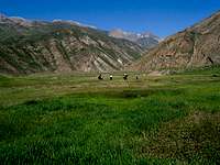
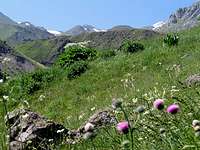
From the village of Nomar, you will hike a streamside trail to a flat grassy area among the mountains known as the Daryook Plain (2350 m)
Pictures of the Daryook Plain

The trail above Daryook Plain

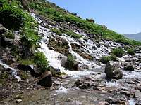
At around 2800 m you will reach a place called Chehel Cheshmeh (Forty Springs) where water pours down the side of the mountain flooding the trail
Pictures of Chehel Cheshmeh
 |  |
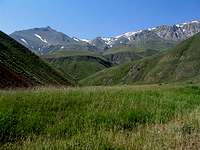
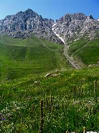
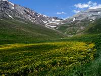
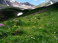
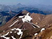
Continuing up the trail past vast fields of wild flowers, you will reach the 3650 m Lehra Saddle where Dokhaharan and its neighbors first come into view. (For more pictures also see the pages for Kaoon and Lehra Peaks)
Pictures of Lehra saddle
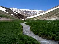
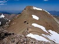
From Lehra Saddle, you will descend to the banks of the Sesang River (3500 m) where you will set up your base camp. The easiest way to the summit of the West Dokhaharan Peak is via the summit of the Takhte Khers Peak where an easy walk-up will get you to the top. (See Photo, See Route for Takhte Khers). With its long and rugged east ridgeline, East Dokhaharan will present much more of a challenge to the climber. The best route is to go up the valley that separates the Sesang Peaks from the Chapakro Peak and then follow the mentioned ridgeline.
Pictures of Sesang River

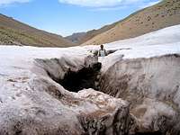
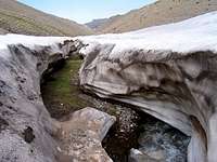
Strange gap in the snow bank on the valley that separates Sesang Peaks from Chapakro Peak
Class III climbing on the east ridgeline of East Dokhaharan

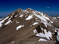
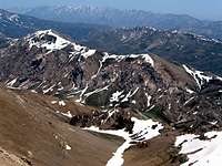
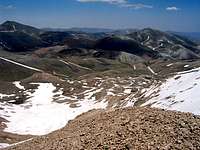
Views from the summit of East Dokhaharan


Getting There
From eastern Tehran, drive the Haraz Road (Tehran-Amol) past the towns of Baijan and Kahrood until you see a sign that says “Amol 55 Km”. A few Kimlometers beyond this sign you will find a dirt road on the left (west) side of the road. This road is well-graded and is passable by most/any car. It might be inconspicuously signed for “Panjab” or “Nomar”. Drive the road 25 km to its end at the village of Nomar (also known as Nomarestagh). Distance from eastern Tehran is roughly 130 Km. |  |