Page Type Page Type: Mountain/Rock
Location Lat/Lon: 36.38265°N / 50.98960°E
Activities Activities: Mountaineering
Seasons Season: Summer
Additional Information Elevation: 14816 ft / 4516 m
Sign the Climber's Log

Overview

Click for Introduction to Central Alborz Mountains.

Click to see the Map of the Takhte Soleyman Massif.


Click for Introduction to Takhte Soleyman Massif.


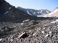
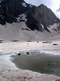
Chaloon is one of the central peaks of the Takhte Soleyman Massif. It rises above the tail end of the Alam Chal Glacier. To the north, Chaloon is connected to the 4472 m Siah Kamaan Peak and to the southwest, it connects to the 4604 m Siah Sang Peak (via a long ridgeline that gives rise to a nameless 4450 m high point). The western slopes of Chaloon are steep rocky/scree slopes that drop down to the bottom of the valley of Alam Chal Glacier.
Chaloon & Alam Kooh from SE
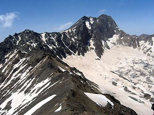
View from the southeast

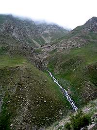
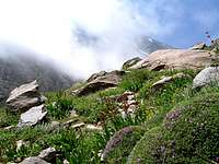
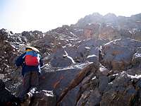
Chaloon is usually climbed along with the nearby Siah Kamaan Peak in a 3 or 2 day program. The usual starting point is the town of Roodbarak (elevation 1400 m) to the northeast. From Roodbarak, you will drive to a place called Vandar Bon (2350 m) and then follow a well-established trail to the 3750 m Sarchal Shelter. From the shelter, you will hike into the valley of Alam Chal Glacier, go up a steep snow covered slope to reach the 4400 m Chaloon Pass and then follow the ridge-top to the summit of Chaloon Peak.
Chaloon from NW
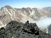
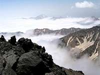
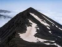
View from the northwest

From the summit of Chaloon, you will have superb views of the north wall of Alam Kooh Peak rising above the Alam Chal Glacier. Much of the rest of the Takhte Soleyman Massif will also be well visible.

Below, you can see pictures of what you will encounter on your way to the summit of Chaloon:

Town of Roodbarak

The picturesque town of Roodbarak sits at an elevation of 1400 m among the beautiful Caspian Forests. The Iranian Mountain Climbing Federation operates a shelter at the west end of the town.
Roodbarak ShelterRoodbarak Shelter

On the trail, 2350-2850 m

From Roodbarak, you will drive to a place called Vandar Bon (2350 m) and then follow a well-established trail.


Trail to Sarchal
Trail to Sarchal


On the trail 2850-3750 m


Trail to Sarchal
Trail to Sarchal
Trail to Sarchal


Sarchal Shelter 3750 m

Sarchal is a multi-room shelter with a capacity for 100 or more people. It is the main hub for climbing Alam Kooh and the other central peaks of the Takhte Soleyman Massif.
Sarchal ShelterSarchal Shelter

Glacial Debris Field 3750-4000 m

Above Sarchal Shelter you will find the valley filled with a huge glacial debris field roughly 3 Km long. Occasional pits created by running water under the debris field expose the thick layer of glacial ice that sits under the debris field.


Glacial RubbleDebris Field
Glacial Ice under Debris FieldIce under Debris Field


Alam Chal Glacier, above 4000 m


Alam Chal GlacierTakhte Soleyman & Shaneh Kooh
Alam Chal GlacierMian-Se-Chal


Interesting Glacial Features

Lakes, streams, deep crevasses and huge boulders are some of the interesting features found on the Alam Chal Glacier.


Glacial LakeLake
Glacial CrevassCrevass
Glacial BoulderBoulder
Glacial StreamStream


Chaloon Pass

The 4400 m Chaloon Pass is located between the 4604 m Siah Sang Peak and Point 4450 m. It sits on the main route to the summit of Chaloon or Alam Kooh Peaks. To reach the pass, you must go up a steep slope that is usually snow covered well into mid summer. Alternatively, you could find your own way up the steep rocky/scree covered slopes.


Chaloon PassChaloon Pass
Finding our own wayFinding our own way


Views from the summit of Chaloon Peak
Alam Kooh PeakView of Alam Kooh Peak (4850 m) from the summit of Chaloon


Takhte Soleyman PeakTakhte Soleyman Peak
Siah Gook PeaksSiah Gook Peaks
Kalahoo & GhabiKalahoo & Ghabi


Zarrin KoohZarrin Kooh
Siah KamaanSiah Kamaan
Gardooneh KoohGardooneh Kooh


Getting There

From downtown Tehran drive 40 km west to the town of Karaj and take the Karaj-Chalus Road north (This road crosses the Alborz Mountains taking you through the Kandovan Tunnel to the Caspian Coast). 30 km south of Chalus, you will reach the town of Marzan Abad. Turn left and follow a side road into the Sardab Rood River drainage and to the town of Roodbarak. Distance from Tehran to Roodbarak is roughly 200 km.

Red Tape

Non Iranian nationals will be charged a small fee ($30 or $50, I don't remember), payable at the shelter in the town of Roodbarak.

Camping

Anywhere.

Shelters available at Roodbarak (1400 m), Vandar Bon (2300 m) and Sarchal (3750 m).

External Links


Children

Children

Children refers to the set of objects that logically fall under a given object. For example, the Aconcagua mountain page is a child of the 'Aconcagua Group' and the 'Seven Summits.' The Aconcagua mountain itself has many routes, photos, and trip reports as children.