
-
 10926 Hits
-
 87.76% Score
-
 25 Votes
|
|
Area/Range |
|---|---|
|
|
45.50298°N / 25.04883°E |
|
|
Hiking, Mountaineering, Toprope, Skiing |
|
|
Spring, Summer, Fall, Winter |
|
|
8100 ft / 2469 m |
|
|
Special thanks to Yatsek, who helped me with the English and gave many suggestions.
Overview
The Iezer Mountains belong to Romania’s highest mountains and comprise a large (extending for about 40 km) wreath of peaks – desolate and high, exceeding 2400m in altitude – whose two massive domes are formed by the Iezerul Mare (Great Iezer) and a sub-group around Păpuşa, the latter rising as an immense, truncated cone in the north-east.The Iezer Mountains can be seen as the easternmost of the several lateral ridges that run south from the main ridge of the Făgăraş Mountains. The massif of Iezer, also known as the Iezer-Păpuşa, is to a considerable extent defined by the Dâmboviţa River, which has its source on its northern slopes, facing the main ridge of the Făgăraş. The Dâmbovița heads north-east from its source but soon takes a sharp turn to flow south-east, toward Bucharest, the capital city of Romania. The deep valley along the upper couse of the Dâmboviţa cuts off the northeastern part of the Iezer Mountains - made up of Păpuşa Peak at 2391m and its surroundings – from the Tămaşu Ridge (the easternmost bit of the main ridge of the Făgăras) and the Piatra Craiului Mountains.
 Păpuşa peak
On the west, the Iezer Mountains are bounded by the valley of the Doamnei River. (The Doamnei River translates as the Lady’s River as legend has it that in the 15th century the first wife of Vlad III Dracula, Prince of Wallachia, chose to die in the waters of the river so as to avoid being captured by the Ottoman army.) The highest peaks, Peak Roşu (Red Peak) at 2470m and Iezerul Mare at 2462m, which rise in the very heart of the Iezer, are connected with Peak Brătila in the main ridge of the Făgăraş by a north-south ridge which has a length of over a dozen kilometers and doesn’t dip below 1860m throughout.
 The ridge The ridge |
 Iezer Iezer |
 To the peak Papuşa To the peak Papuşa |
The Iezer’s main ridge is about 40 km long and looks like a horseshoe that embraces the headwaters of the Târgu River, which is – like the Doamnei and the Dâmboviţa – a tributary of the Argeş. The landscape is most rugged, stark and rocky on the northern flank, within the areas named Colții lui Andrei and Boarcaşu, as well as around the sources of the streams originating near Lake Iezer, on the opposite side of the main ridge. The main ridge – between Papau in the south-west and Păpuşa in the north-east – does not dip below 2000m, its central part generally rising above 2200m, except for Bătrînei Pass (2190m) which sits midway along the ridge. On both sides of the main ridge there are postglacial cirques in each valley, but only one of them cradles a decent lake. It is this lake that the Iezer Mountains take their name from.
Lake Iezer, sitting at 2130m in a cirque just south-east of the summit of Iezerul Mare, has an area of approx. 0.5 ha and a maximum depth of 4 to 5 meters. There are also two small tarns at the headwaters of the Boarcăşului River, just north of the highest summit of the mountains, Peak Roşu.
 Iezer lake
Access
- By train
Some villages/towns and distances: Câmpulung, Lereşti and Voineşti respectively 5 and 8 km from Câmpulung, Nămăieşti, 8 km from Câmpulung, Rucăr, 24 km from Câmpulung, on DN73, Podu Dâmboviţa, 29 km from Câmpulung, the DN73, Domneşti, 30 km from Câmpulung and 22 km from Curtea de Argeş, on DN73, Bahna Rusului, 20 km from Royal, Bughea de Sus, 5 km from Câmpulung, Albeşti, 10 km from Câmpulung, Cândeşti 15 km from Câmpulung.
Geology
Crystalline schists, rather slightly metamorphosed, are extremely widespread. Occasionally they give way to gneiss, which appears along the main ridge between the peaks of Papau and Batrâna. Limestone, Jurassic and Cretaceous, only occurs in the far south-east corner of the Iezer Mountains as an extension of the southernmost part of the Piatra Craiului Mountains, near Podu Rucăr Dâmboviţa and Dragoslavele. In some peripheral areas in the south other sedimentary rocks, such as conglomerates, can be found. School route 3B
Near Albeşti there are ancient limestone quarries and fossils which have been designated a nature reserve. The paleontological and geological reserve of Albeştii de Muscel, located on the outskirts of the village of Albeştii, 15 km from Câmpulung, is made up of two monuments of nature: Numulitic Eocene Limestone, rich in fossils of nummulites; and Albeşti Granite - a mass of magma injected into the midst of the prevailing crystalline schists, which has an area of 300 square meters.
Climate
Because of a specific location of the Iezer, just south of the Făgăraş Mountains and west of the Piatra Craiului, the climate has some specific characteristics. On the highest ground, the mean annual temperatures are about 2 degrees Celsius, mean January temperature down to -7 °C and the average temperature of July is as low as 8 °C.The prevailing winds blow from north-west. During the winter season wind speeds of 90-100 to 120-140 km/h have been recorded, which results in the development of ice crust, especially on the south-facing slopes within the alpine zone.
Cloudiness is generally frequent and extensive, owing to the air being forced to ascend - regardless of which direction the wind is blowing from - by mountain barriers that run both east to west and north to south. As a result, the number of days with cloud cover exceeds 200.
Rainfall is abundant, the annual average reaches 1200-1300 mm and rain can be expected almost all year round. Snow starts falling by October and lasts until May, which equates with an annual average of 180 to 220 days with snow on the ground and 250 to 260 days with ground frost. In May you can still go skiing in the cirque by Păpuşa Peak where the compact snow lasts until mid-June.
 |
 |
 |
Flora
Vegetation occurs in distinct altitudinal zones. Deciduous woods - predominantly beech (Fagus silvatica), with an admixture of birch (Betula pendula) and sycamore (Acer pseudoplatanus) – cover a large share of the lower slopes at 850-1250m. Higher up, between 1250 and1450m asl, the fir (Abies alba) and spruce (Picea abies) shows up to finally take over at 1450-1500m. The coniferous trees can be found up to the heights of 1800-1850m, where the realm of subalpine bushes begins, featuring the dwarf mugo pine (Pinus mughus), Carpathian rhododendron (Rhododendron kotschyi), bilberry (Vaccinium myrtillus) and juniper (Juniperus nana).In the clearings within the forest zone, the following species of flowers are to be found: Carpathian crocus (Crocus heuffelianus), snowdrop (Galanthus nivalis), anemone (Anemone nemorosa), oxeye daisy (Chrysanthemum leucanthemum), Campanula obietina. Among the flowers you can enjoy seeing in the subalpine zone there are several species of campanulas (bells), carnations, gentians and violets; the yellow monkshood (Aconitum anthora), thyme (Thymus alpestris), tundra pink (Dianthus gelidus), least primrose (Primula minima).
Fauna
The forest Wolves footprints
The mountain waters are inhabited by the trout (Salmo trutta), grayling (Thymallus thymallus), bullhead (Cottus gobio).
Huts & Refuges
Voina chalet at 983m asl. - 140 places in rooms with 2, 4 and 6 beds- Electricity, running water, bathroom
- Restaurant, covered terrace, bar
- Parking in front of the hut
- Access: via DN 73, the city of Câmpulung Muscel, on the forest road with car access; trails to Cuca chalet, Lake Iezer, Păpuşa Peak.
- Open most of the year.
Phone numbers: 0722 329544; 0722 595328; 0788 362388; 0248 511330; 0248 512990; 0248 822634; 0248 831373.
Cuca Hut at 1210m asl. – 24 places in 2 rooms with 12 beds each, 30 places
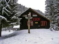 Cuca hut
- Heating (wood stoves)
- No restaurant
- Kitchen: stove, table
- Water from the spring 20 m from the chalet
- Location: at the foot of Mount Grădişteanu
- Access: in summer you can come by car via the forest road from Voina; a winter walk from Voina Hut takes about half an hour.
Iezer Refuge at 2165m - 30 places in 2 rooms, rudimentary facilities
- Shelter made of stone, well insulated
 Iezer refuge
- Rescue team can be present on the weekend
- Small dining room with a hob, and a room with a bunk
- The room from the left side is closed, it is just for the rescue team.
- Wood stove
- Location: by Lake Iezer, below the peak of Iezerul Mare
- Trails: from chalet Voina by Valley Jepilor (not in winter), Piciorul Iezerului (winter route) or Culmea Văcarea.
- Water from a nearby spring.
In case of emergency can be use the sheperd refuges, of course just in the winter when they are not there.
Camping
 Bivy
BivyWherever you want...
Red Tape
There's no red tape in Iezer.Weather

Maps
 |
 |
 |
