
|
|
Area/Range |
|---|---|
|
|
48.92250°N / 19.51721°E |
|
|
Hiking, Mountaineering, Sport Climbing, Skiing |
|
|
Spring, Summer, Fall, Winter |
|
|
6703 ft / 2043 m |
|
|
Overview
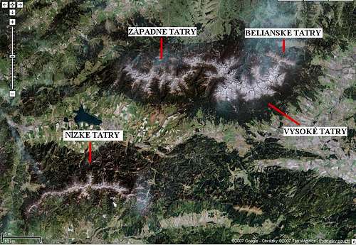
The mountain range of Nízke Tatry (Lower Tatras) is 80 km long and is located between the valleys of Váh and Hron Rivers. In the main ridge, there are three mountains rising above 2000 m - Ďumbier (2043 m), Chopok (2024 m), and Dereše (2004 m).Tourism infrastructure is located mainly in the middle of Nízke Tatry in the valleys below Chopok. In the northern part it is Demänovská dolina Valley (Lúčky, Zahrádky, Jasná) and in the south it is Bystrá dolina Valley (Tále, Srdiečko, Kosodrevina, Mýto pod Ďumbierom).
Tourist resort in the western part of these mountains is Donovaly , and in the eastern part Liptovská Teplička and Telgárt.
The main tourist resort for Chopok-North area (to Demänovská dolina) is Liptovský Mikuláš, for Chopok-South (Bystrá dolina Valley) it is Podbrezová and Brezno. In 1964, all villages in Demänovská dolina have merged into one big village - Demänovská Dolina.
Contrary to overcrowded High Tatras, the area of Lower Tatras is really wild (except the area of Chopok - due to a cable car).
Tatras
In 1978 the whole area of Nízké Tatry was declared a National Park – NAPANT (Národný Park Nízke Tatry).
Nízke Tatry are 70% covered by woods.
Demänovská dolina Valley has the deepest cave system in Slovakia (Starý Hrad -432 m) and Demänovský kras Carst is the longest carst system in Slovakia (24 km).
The deepest gorge - Veľká ľadová priepasť (125 m).
The highest waterfall - Brankovský vodopád (55 m).
The largest lake - Vrbické pleso (1,8 ha). It is the only one in Nízke Tatry. There is another one - below Ďumbier, but it is only seasonal.
The biggest reserve - Skalka (2659 ha).
Pictures from Nízke Tatry from SP member Darek
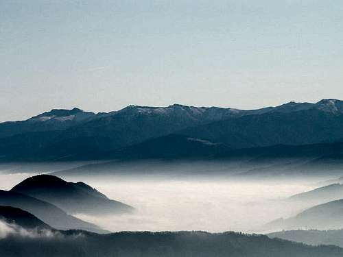
Nízke Tatry from Malá Fatra
Division of Lower Tatras
Nízke Tatry are part of Karpaty mountains. They are covering an area of 2000 km². From the northern side, they are delimited by Liptovská kotlina Basin and from the south by Horehronie. This range is 80 km long, with average width of 30 km. On the western side it is delimited by Revúca River, Šturec Saddle (1010 m), which separates Nízké Tatry from Veľká Fatra, and Starohorský potok Stream, on the eastern side it is delimited by Popová Saddle (1056 m) and by the road linking regions of Spiš and Gemer .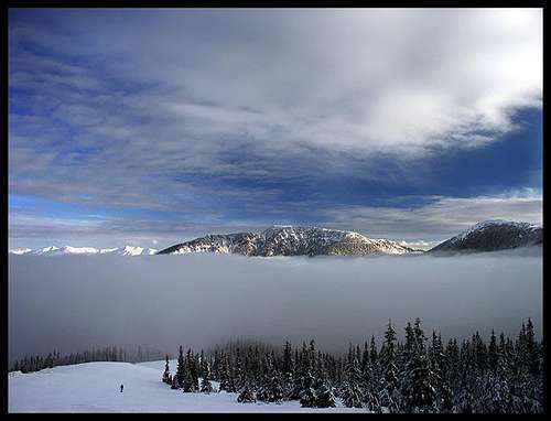
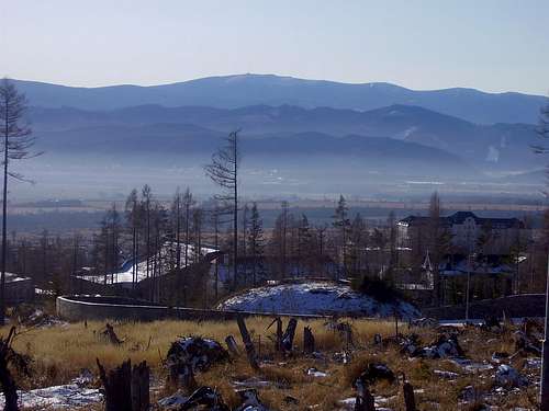
Chopok
Nízke Tatry can be divided into three parts: western part – massif of Prašivá (1754 m), middle part - Ďumbierske Tatry with the highest mountain Ďumbier (2043 m) and eastern part - Kráľovohoľské Tatry with Kráľova hoľa (1948 m).
But, more often, they are divided only into two parts - eastern = Ďumbierske Tatry and western = Kráľovohoľské Tatry .
Western part is mostly grassy, except the massif of Ďumbier . The most important is the massif of Prašivá . The ridge of Prašivá is 10 km long section of the main ridge of Nízke Tatry, stretching from Hiadeľské sedlo Saddle (1099 m) to Sedlo pod Skalkou Saddle (1500 m). The highest point of this ridge is Veľká Chochuľa (1753 m). Another important mountain in this section is Chabenec (1955 m). At the foot of this mountain, there is the highest village in Slovakia, the old mining settlement Magurka (1050 m).
 |
Western and High Tatras from Chopok
The most often visited is middle part of Nízke Tatry. Here is located the highest mountain of Nízke Tatry - Ďumbier (2043 m) and other highest mountains in this range, including Chopok - with its big ski resort. In the area of Ďumbier, there were an intensive mining activities on its slopes (iron ore, gold and stibnite). In the period of WW2 there was fighting (in the saddle between Ďumbier and Králička) between partisans and German soldiers. In the memory of the fallen partisans, there is a Monument to Fallen Partisans, built in the vicinity of Chata M.R. Štefánika Hut.
The group of Ďumbierské Tatry ends in Čertovica saddle (1238 m). The ridge continues in the eastern direction by grassy slopes again.
The most importants mountains in the eastern part are: Čertova svadba (1457 m), Homôľka (1661 m), Veľká Vápenica (1691 m), Andrejcová (1585 m), Orlová (1841 m) and the highest mountain of this part - Kráľova hoľa (1946 m).
Kráľova hoľa
The highest mountains of Ďumbierské Tatry:
- Ďumbier (2043 m)
- Chopok (2024 m)
- Dereše (2003 m)
- Skalka (1980 m)
- Chabenec (1955 m)
- Kotliská (1940 m)
- Poľana (1890 m)
The highest mountains of Kráľovohoľské Tatry:
- Kráľova hoľa (1946 m)
- Stredná hoľa (1876 m)
- Orlová (1840 m)
- Veľký bok (1727 m)
- Veľká Vápenica (1691 m)
National Park Lower Tatras
Národný park Nízke Tatry - NAPANTNational Park was declared in 1978. It is the largest protected area in Slovakia - 205 085 ha.
There area 20 small-area protected areas, 10 National Nature Reserves (NPR), 5 National Nature Monuments (NPP), 6 nature monuments (PP) and 2 protected areas.
- NPR Demänovská dolina - 1973, 837 ha; the best known caves in Slovakia, protected fauna and flora, one of the most important protected area in Slovakia
- NPR Ďumbier – 1973, 2044 ha, on the northern slopes of Ďumbier (Bystrá, Ludrová, Štiavnica valleys), protection of glacial relief and alpine meadows;
- NPR Hnilecká jelšina – 1988, 84,5 ha
- NPR Jánska dolina – 1933, 1694,5 ha
- NPR Ohnište – 1973, 852 ha, the area built by limestones and dolomites
- NPR Pod Latiborskou hoľou – 1964, 161 ha, original woods on the southern side of Nízke Tatry
- NPR Príboj – 1895, 11 ha, the oldest Nature reserve in Nízke Tatry
- NPR Salatín – 1982, 1193 ha, carst terrain
- NPR Skalka – 1997, 2660 ha, alpine and glacial relief
- NPR Turková – 1965, 107 ha
- PR Baranovo – 1993, 16 ha, wildwood
- PR Barania hlava – 2006, 13 ha
- PR Breznianska skalka – 1981, 12 ha
- PR Horné lazy - 1981, 34 ha
- PR Jelšie – 1973, 26 ha
- PR Kozí chrbát – 1993, 37 ha
- PR Mackov bok – 1976, 3,7 ha
- PR Mačková – 1993, 42 ha
- PR Martalúzka – 1999, 155 ha
- PR Meandre Hrona – 1980, 103 ha
- PR Sliačske travertíny – 1983, 7 ha
- PR Štrosy – 1999, 95 ha
- PR Vrchovisko pri Pohorel. Maši – 1979, 27 ha
- NPP Brankovský vodopád – 1980, 28 ha
- NPP Bystrianska jaskyňa – 1972, 93 ha
- NPP Demänovské jaskyne – 1972, 680 ha
- NPP Stanišovská jaskyňa – 1972, 219 ha
- NPP Vrbické pleso – 1975, 25 ha
- PP Ľupčiansky skalný hríb – 1979, 2 ha
- PP Mašiansky balvan – 1965, 1,3 ha
- PP Meandre Lúžňanky – 1988, 2 ha
- PP Moštenické travertíny – 1981, 1.7 ha
- PP Strž – cancelled, 1974, 0.3 ha
- PP Žiar – cancelled, 1975, 2 ha
- CHA Bodický rybník – 1952, 18 ha
- CHA Revúca – 2002, 4 ha
- CHA Jakub – 1999, 13 ha
- CHA Brvnište – 2007, 75 ha
Administration of the National Park
| Správa NAPANT | tel. | fax |
| Internátna 2, 974 01 Banská Bystrica | +421 484 130 888 | +421 484 130 820 |
| +421 48 4130 889 | ||
| Ulica SNP 11, 033 01 Liptovský Hrádok | +421 44 5222 875 | +421 44 5221 082 |
| +421 44 5221 082 |
Red Tape
There are no such restrictions as in High Tatras, but remember, it is a National Park, so you can walk only along the marked paths. Camping is allowed only in designed places, picking plants is forbidden.Seasonally closed paths: (16.10. - 30.6.)
- Kotliská - Žiar
- Poľana - Sedlo Siná
- Dolina Vyvieranie
The path leading from Chata M.R. Štefánika to Ďumbier is closed in the summer. You have to go via Krupovo sedlo.
The main ridge is marked in winter by wooden sticks.
Areas for skiing:
a) Demänovská dolina Valley – Chopok North
Biela púť
Jasná - Luková
Luková - Chopok
Otupné
Otupné - Brhliská
Otupné - Luková
Rovná hoľa - Chopok
Rovná hoľa - Konský Grúň
Záhradky
Záhradky - Priehyba
Záhradky - Rovná hoľa
Lúčky
Repiská
b) Horná Lehota - Chopok South
Krupová
Kosodrevina - Chopok
Srdiečko - Kosodrevina
Predná Derešská mulda
Zadná Derešská mulda
c) Partizánska Ľupča
Magurka
Železnô -Senná kopa
Areas for climbing:
a) Dereše North - Kohútik
b) Demänovská dolina - Machnatô
c) Liptovská Porúbka - Sielnica
d) Demänovská dolina - Blatník (15.8. do 31.1.)
Areas for ski-mountaineering:
- ridge Poľany - Krúpova hoľa: from the north limited by the yellow marked path Nr. 8619/a (Poľany 1873 m - Tri vody - Zadná voda) and from the east by the green marked path Nr. 5426 (Krúpova hoľa 1922 m - Široká dolina -Lúčky)
- ridge Dereše - Chata M. R. Štefánika hut: from the south limited by the line Dereše - Oblaz, from the east by Trangoška Valley
- other areas only along the winter marked routes
Mountain Rescue - Horská služba
www.horska-sluzba.sk/index.phpOn the ridge of Nízke Tatry:
* Dom HS Čertovica
* Dom HS Donovaly
* Kamenná chata pod Chopkom
* Chata gen. štefánika pod Ďumbierom
* Horský hotel Čertovica
* Hotel Junior Krpáčovo
* TV tower on Kráľova hoľa
Out of the ridge:
* Dom HS Jasná
* Horský hotel Trangoška
* Hotel Mýto pod Ďumbierom
* Pension Jarabá
* Hotel Biotika Krpáčovo
* Hotel Junior Krpáčovo
* Hotel Pusté Pole - Besník
* Pohorelá Ján Šulej
Caves
Bystrianská jaskyňa – protected since 1973; in the vicinity of Bystrá. Over 1 km long. The cave consists of two parts: Stará (Old) and Nová (New) jaskyňa.Demänovská ľadová jaskyňa – in the Demänovská dolina Valley. It is one of the oldest known caves in the world. It is mentioned in the document from 5.12.1299. The first time it was explored by Juraj Buchholtz jr. in 1719.
Demänovská jaskyňa Slobody in Demänovská dolina Valley. It was discovered by A. Král and A. Mišura in 1921. This cave is - together with neighbouring Pustá jaskyňa - 8900 m long.
Važecká jaskyňa – protected since 1972 in the vicinity of Važec in the valley of Biely Váh. It was discovored by Ondrej A. Húska 8.7.1922.
Jaskyňa mŕtvych netopierov - 16,2 km long and 300 m deep cave
Huts and Camping
TV tower Kráľova hoľa 1946 mIn this facility, there is a room designed only for emergency stay. There are two benches and a container with drinking water.
Shelter on Andrejcová , 1420 m
Shelter on the southern side of Andrejcová, for 20 people; you need to have a sleeping bag.
Ramža shelter 1290 m
15-20 people.
Chata gen. M. R. Štefánika 1740 m
(tel. 048/6195120, Link)
The hut in the main ridge between Králička and Ďumbier opened in 1928. It has 50 beds in the heated rooms and 20 beds in non-heated rooms.
270 Sk per night
Kamenná chata pod Chopkom 2000 m
(tel. 048/6170039, Link)
The hut below the summit of Chopok. It was built in the 50s.
250 Sk per night
Chata Ďurková pod Chabencom 1623 m
The hut in the vicinity of Ďurková Saddle.
70 Sk per night
Contact:
00421-(0)-908-133027
00421-(0)-908-231564
00421-(0)-908 551711
00421-(0)-918-091859
Few informations added by Dmiki
Kamenná chata pod Chopkom - very quick replies to e-mail, good English.
Chata Štefánika - they seldom read their e-mail, and are very slow to respond; call them if you want to make a reservation; waitresses with lovely warm smiles.
Chata Ďurková - the warden is sometimes out, but the hut is open and you can find the firewood and water from the spring nearby.
Camps
ATC Bystrina - Pavčina Lehota (Demänovská dolina),
ATC Tále
ATC Kamzík - Donovaly
ATC Poľana - Malužiná
ATC Vavrišovo
ATC Pohorelská Maša
ATC Nemecká
ATC Borová Sihoť - Liptovský Hrádok
ATC Gindura - Pohorelá
Paths
The most interesting is so-called Cesta hrdinov SNP . It is almost 80 km long path, leading from Donovaly to Telgárt, over the main ridge of Nízke Tatry. It takes approximately 4 days.Donovaly – Kečka (1225 m) – Handliarka (1211 m) – Kozí chrbát (1330 m) – Hiadeľské sedlo (1099) – Prašivá (1652 m) – Malá Chochuľa (1719 m) – Veľká Chochuľa (1753 m) – Košarisko (1694 m) – Veľká hoľa (1640 m) – Latiborská hoľa (1643 m) – Zámostská hoľa (1612 m) – Ďurková (1750 m) – Sedlo Ďurkovej (1709 m) – Chabenec (1955 m) – Kotliská (1937 m) – Krížske sedlo (1775 m) – Poľana (1890 m) – Sedlo Poľana (1873 m) – Dereše (2003 m) – Chopok (2024 m) – Konské (1874 m) – Demänovské sedlo (1756 m) – Krúpova hoľa (1922 m) – Panská hoľa (1635 m) – Kumštové sedlo (1549 m) – Rovienky (1602 m) – Čertovica (1238 m) – Sedlo za Lenivou (1378 m) – Bacúšske sedlo (1319 m) – Jánov grúň (1387 m) – Homôlka (1660 m) – Zadná hoľa (1619 m) – Oravcová (1544 m) – Kolesárová (1508 m) – Sedlo Priehyba (1190) – Veľká Vápenica (1691 m) – Sedlo Priehybka (1468 m) – Heľpianský vrch (1586 m) – Andrejcová (1519 m) – Ždiarské sedlo (1473 m) – Bartková (1790 m) – Orlová (1840 m) – Kráľová hoľa (1946 m) – Telgárt
In the northern side of Nízke Tatry there are 515 km of marked paths.
Examples:
- Lúčky – green marked path – Pod Krčahovom – Široká dolina Valley – Krupova hoľa (1922 m) – red marked path – Ďumbier (2043 m) 3 ¼ h.
- Demänovská dolina – Vrbické pleso Lake – blue marked path – Pod Orlou skalou – Luková – Chopok 2 ¾ h
- Chopok – Dereše – red marked path 45 min
- Chopok – Ďumbier – red marked path 1 ¾ h
- Srdiečko – yellow marked path – Chopok 2 ¾ h
- Čertovica – red marked path – Rovienky (1602 m) – Kumštové sedlo (1549 ) – Panská hoľa (1635 m) – Králička – Chata gen. M.R.Štefánika (1727 m) – Ďumbier (2043 m) 4 ¾ h
- Krpáčovo – red marked path - Strmý vršek (809 m) – yellow marked path – Dolná Studená – Žiar (1408 m) – Žiarská hoľa (1840 m) - Skalka (1980 m) 5 h
- Magurka (1050 m) – yellow marked path – Zámostská hoľa (not to the summit) on the ridge along red marked path to Ďurková (1750 m) – Sedlo Ďurkovej (1705 m) – Chabenec (1955 m) 4 h
- Polianka – red marked path – Kečka (1225 m) – Handliarka (1211 m) – Kozí chrbát (1330 m) – Hiadeľské sedlo (1099 m) – Prašivá (1652 m) – Malá Chochuľa – Veľká Chochuľa 5 h
- Donovaly – red marked path – Zvolen (1402 m) 1 1/2 h
- Telgárt (881 m) – green marked path – Kráľova skala (1690 m) - Kráľova hoľa (1946 m) 3 1/2 h
External links

The weather forecast for Chopok
Web cams in Jasná
Jasná - web site
Avalanche info (added thanks to dmiki)
dmiki - Feb 29, 2008 9:13 am - Voted 10/10
hutsKamenná chata pod Chopkom - very quick replies to e-mail, good English. Chata Štefánika - they seldom read their e-mail, and are very slow to respond; call them if you want to make a reservation; waitresses with lovely warm smiles. Chata Ïurková - the warden is sometimes out, but the hut is open and you can find the firewood and water from the spring nearby.
dmiki - Mar 2, 2008 6:13 am - Voted 10/10
Avalanche infoImage containing up-to-date avalanche risk information for Tatras and Fatras http://www.laviny.sk/inc/HZS_lavinovka.php With a link possibly pointing to preferably http://www.laviny.sk/index.php?menu=lavinovka E.g. (Idea from http://www.hory.sk/)
dmiki - Mar 2, 2008 6:50 am - Voted 10/10
MapsA not too detailed, but useful map of Slovakia (under 'list of maps' you can search for National parks, mountains, reserves and zoom in) http://www.slovakia.travel/maps.aspx?l=2&p=99&so=-1&sokf=False
dmiki - Feb 25, 2010 12:57 pm - Voted 10/10
Jasna webcam linksseem to be broken
Gorzi - Feb 25, 2010 4:54 pm - Hasn't voted
Fixed...Links are fixed now. Thank You for this notice.
peterbud - Mar 22, 2013 5:46 am - Voted 10/10
Informative article, could be appended as a childhttp://www.summitpost.org/main-ridge-of-low-tatras/719880