
|
|
Area/Range |
|---|---|
|
|
49.19247°N / 19.03519°E |
|
|
Hiking, Mountaineering, Sport Climbing, Skiing |
|
|
Spring, Summer, Fall, Winter |
|
|
5607 ft / 1709 m |
|
|
News
New Canyon´s page added by visentin - Horné Diery & Nové DieryNew pictures from my trip to Malá Fatra from 20.4.2007 added.
The cable car Vrátna-Snilovské sedlo is running till the end of April only on Saturdays and Sundays.
Overview
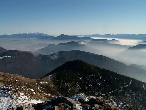
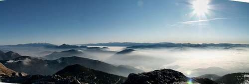 View from the top of Chleb
 Map of the main ridge
The origin of a name Fatra
At first it was a name for a mountain. As a name of whole range, it appears in 18th century. According the folk etymology it is derived from a word Vater (Father), but according scientific researches it is derived from observation function of these mountains. (Noun "patra" is derived from verb "patriti" = look, view; and later was a letter P replaced by F).
Length: 52 km
Max.width: 16 km
Average annual temperature: 3-6 C
Annual rainfall: 1200-1400 mm
The Malá Fatra mountain range (Low Fatra) with the extended one of 22.630 hectares were declared the Protection area in 1967 and then the National Park in 1988. The mountain range is formed by granitoid rocks, rocks of the envelope and sheet units, especially dolomites and limestone. The park is rich of flora and fauna (bear, lynx, otter, eagle, eagle owl, grouse).
The Malá Fatra mountain range is divided into two parts: Kriváňská Fatra (highest point - Velký Kriváň-1709 meters) and Lúčanská Fatra, often called Martinské Hole, which isn´t correct (highest point - Velká Lúka - 1476 meters).
 Kľak and Krížná in Lúčanská Fatra
This mountain range emerges out of the Žilinská kotlina and Turčianská kotlina basins and forms an arch extending from the Fačkovské sedlo pass to Zazrivá. The park covers territory of the districts of Žilina, Martin, Ružomberok and Dolný Kubín.
More than 80% of the national park area is covered by mixed forests, predominantly beech, with more than 900 kinds of plants growing here.
Protected areas:
National nature reserves:
Chleb (1967, 413 ha)
Minčol (1980, 96.1 ha)
Krivé (1979, 203.72 ha)
Šútovská dolina (1967, 527 ha)
Sokolec (1980, 199 ha)
Suchý (1979, 429 ha)
Starý hrad (1967, 85.4 ha)
Prípor (1980, 272 ha)
Šíp (1980, 302 ha)
Šramková (1967, 244 ha)
Rozsutec (1967, 842 ha)
Tiesňavy (1967, 479.21 ha)
Velká Bránica (1967, 332.09 ha)
Klačianská Magura (1976, 204 ha)
Nature reserves:
Dubovské lúky
Golové mľaky (1988, 6.83 ha)
Hajasová (1976, 7.17 ha)
Hrabinka (1988, 0.40 ha)
Hrádok (1976, 6.75 ha)
Kraľovianský meander (1990, 18.2 ha)
Močiar (1993, 8.16 ha)
Párač
Pod Rígľom (1984, 14.2 ha)
Velká Lučivná (1967, 66.4 ha)
Nature monuments:
Borická mľaka (1974, 0.60 ha)
Domašinský meander (1978, 80.4 ha)
Krásnianský lúh (1989, 15.2 ha)
Šútovská epigenéza (1979, 52.2 ha)
Lúčanská Fatra - to the south of the Váh River. The main ridge of this group goes from Fačkovské saddle to Javorina saddle.
Borders: to the east - the Turiec River, to the west - the Rajčianka River.
Fačkovské saddle (802 m)-Kľak (1352 m)-Ostrá skala (1220 m)- Vrické saddle (950 m)- Skalky (1191 m)- Janková (1163 m)-Sedlo pod Úplazom saddle (988 m)- Úplaz (1085 m) - Sedlo pod Hnilickou Kyčerou saddle (1028 m)-Hnilická Kyčera (1218 m)- Mariková saddle (990 m) - Kopa (1232 m)- Horná Lúka (1299 m)- Veterné (1442 m)- Velká Lúka (1475 m)- Krížava (1457 m)-Zazrivá (1394 m)- Minčol(1364 m )- Úplaz (1301 m)- Javorina saddle (967 m).
Kriváňská Fatra - named after its highest point Velký Kriváň, is situated to the north of the Váh River.
Main ridge : Suchý (1468 m) - Vrata saddle (1462 m) - Stratenec (1513 m) - Priehyb saddle (1462 m) - Malý Kriváň (1671 m) - Bublen saddle (1510 m) - Pekelník (1609 m) - Velký Kriváň (1709 m) - Snilovské saddle (1524 m) - Chleb (1647 m) - Hromové (1636 m) - Za Hromovým saddle (1550 m)- Steny, south summit (1572 m) - Sedlo v Stenách (1480 m) - Steny, north summit (1535 m) - Poludňový gruň (1460 m) - Stohové saddle (1230 m) - Stoh (1607 m) - Medziholie (1185 m) - Velký Rozsutec (1610 m) - Medzirozsutce (1225 m) - Malý Rozsutec (1343 m).
Highest points:
Velký Kriváň 1709 m

Malý Kriváň 1671 m

Chleb 1646 m

Hromové 1636 m

Velký Rozsutec 1610 m

Pekelník 1609 m

Stoh 1607 m

Steny - south summit 1572 m, north summit 1535 m


Stratenec 1513 m

Malý Rozsutec 1344 m

Getting There
The nearest airports are in Ostrava (CZ), Bratislava and Poprad (both SK). The area of Malá Fatra has good traffic connection with the whole Slovakia and Czech Republic. From the czech-slovakian borders we can use the road nr. E75 leading through Jablunkov (the easternmost city of the Czech Republic) toward Čadca (already in Slovakia). In Krásno nad Kysucou we turn right under the bridge and there we turn left in the direction of Stará Bystrica (road nr. 520), and before this village we turn right again. On the crossroad a few kilometeres after Lutiše, we turn left and from there it is only few kilometeres to Terchová (from the right comes to this crossroad a road from Žilina - it is maybe easier for orientation, but a little bit longer).In Terchová we turn right (maybe second or third turning behind a church) to the Vrátna valley. From Vrátna valley we can go to the left to Štefanová village or straight to the Vrátna hut).

Malá Fatra National Park
The territory of Kriváňská Malá Fatra was declared as Landscape Protected Area in 1967. Malá Fatra National Park was established in 1988.ENTRANCE RULES OF THE MALÁ FATRA NATIONAL PARK
§4 Condition of NP Land Use
1) Basic rights and duties of NP visitors are defined by the special regulations
2) Territory of the NP, national nature reserves, nature reserves are on the circumference borders and tourist trail passings is marked by the state sign table, to which an additional information table may be added.
3) Territory of the NP is accessible to visitors, especially for the purpose of nature history and environmental education. Tourist trails, interpretive trails and visitors´centers were built for this reason.
4) Visitors can only use the tourist and interpretive trails except the trails passing of which was prohibited by the state administration of nature and landscape conservation.
5) Visitors within the territory of the NP have to avoid activities that could negatively effect or deadly injure plants and animals or destroy their habitats including garbage and noise pollution. It is forbidden to damage, tear, dig out, and collect (pick) the protected plants and disrupt protected animals, especially to kill, injury, catch or transfer them and destroy their habitats and nests. It is also forbidden to destroy and damage trees.
6) Visitors of the NP can enter the territory of the NP only with leashed and muzzled dogs.
7) On car entry and parking in territory of the NP, agreement of the state administration of nature conservation is required. Public land communications with unlimited car traffic that are stated in the Appendix of this order are subject of the exception. Parking is possible only in selected parking places stated in Appendix up to their capacity.
8) There are selected places in the territory of the NP in which downhill and alpine skiing, hiking, rock and alpine climbing, and biking is allowed. List of designated and selected trails and sites is given in the Appendix.
9) Camping, bivouacing, mass sport, recreational, and other social undertakings, and, also, providing sport activities mentioned in the section 8 except the designated and restricted trails and sites where the above stated activities is possible to carry only with the permission or exception clause of the Act given by the state administration of the nature conservation.
10) Burning fires is allowed only in the selected places in the area of recreational objects and inns.
11) Sight seeing and practice low flights by airplanes are in the territory of the NP strictly prohibited.
12) The territory of national nature reserves and nature reserves is under 5. level of protection. Except the above stated conditions regarding visitor rules, any man activities listed under §17 of the Act especially hiking out of the mentioned tourist trails, harvesting plants and fruits, minerals and fossils, destroy vegetation and soil layer, enter the chasm and caves, smoke, make noise, and pollute environment by trash.
Appendix
I. List of interpretive trails
Štefanová - Diery - Boboty
Šútovská valley
II. Visitors centers
IS Štefanová (Vrátna valley)
III. Selected areas and trails for
1) DOWNHILL SKIING
a) Vrátna valley (Poludňový Gruň, Paseky, Príslop, Cizinka, Oštiepková mulda, meadow by Boboty Hotel)
b) Malá Lučivná (Malá Lučivná, Magurka)
2) HIKING TRAILS
All hiking trails are opened except the below listed closed trails
a) Obšívanka - Malé Nocľahy (blue marking, this trail was closed in the period 1998 - 2005, it is open now)
b) Medziholie - Velký Rozsutec - Medzirozsutce (red marking, closed in the period from 1.10. until 30.6.)
c) Skalné mesto - Poludňové skaly - Húty (blue marking, Vrátna and continuing tourist trail Húty - Poludňové skaly - Tanečnica)
3) ALPINE AND ROCKCLIMBING
a) Site Mních in the Tiesňavy National Nature Reserve is closed in the period from 15.8. until 28.2.
4) ALPINE SKIING
a) To begin on the trail Štefanová - by blue marking toward Gruň - through downhill course up to Poludňový Gruň - by red marking along mountain ridge to Snilovské sedlo - by marked downhill course to the end of Vrátna valley - by yellow marking to Gruň - by blue marking to Štefanová. It is forbidden to hike away the designated trail.
5) RIDING BIKES OF ANY TYPES IS ALLOWED
a) Zazrivá - Párnica
b) Zazrivá - Zazrivá Biela
c) Terchová - end of the Vrátna valley with the deviated route to the Hotels in Sokolie and Štefanová
IV. The territory of the Malá Fatra NP is crossed by the three land roads with unlimited car traffic:
1) Zazrivá - Párnica in the section Podskalie - Majdovec
2) Zazrivá Biela in the section Podskalie - settlement Biela
3) Terchová - end of the Vrátna valley with the deviated route to the Village of Štefanová and to the Hotels in Sokolie
V. Selected parking places
1) Vrátna valley - Štefanová, Starý dvor, and the end of the Vrátna valley
2) Malá Lučivná
Administration of NP:
Správa NP Malá Fatra
Hrnčiarská ul. 197
013 03 Varín
tel. 0415692311
or
Nám. sv. Floriána 1002,
013 02 Varín
tel.: +421/41 569 53 31
ssnpms@sopsr.sk
Mountain Rescue Team (Horská služba)
Dom Horskej služby - Vrátna
01306 Terchová
tel.: 0415695232
Rescue station of HS: Martinské hole
0434222662
External Links
Page about Mala Fatra, but unfortunately it is currently under constructionSome trips in MF, but only in Czech
Some trips in MF, but only in Czech
Beautiful pictures of Fatra and Tatras
Camping and huts
Camp KamenceEach village in this area offers a lot of accomodation.
Huts:
Chata pod Chlebom (1423 m)
Hut below the summit of Chleb (450 m from its summit, or 950 m from Snilovske saddle).
Accessible from Šútovo (bus stop Rieka, 450 m) - Šútovský vodopád watterfall (38 m high) - Mojžíšové pramene - Chata pod Chlebom; blue marked trail, 3 3/4 h
Contact: +421 (905) 861042
Prices: 150-230 Sk (1 person per night)
Chata na Gruni (970 m)
Hut in the vincinity of the ski resort Vrátna dolina. It is located 45 min from Vrátna hut (yellow marked trail) and 1 hour from Štefanová.
Contact: +421-41-5695324
+421-903-524200
Prices: 200-300 Sk (1 person per night)
Chata pod Suchým (1075 m)
Accessible from Strečno, through Starý hrad, 2 3/4 h (red marked trail).
Contact: +421 (903) 527528
Prices: 150-200 Sk (1 person per night)
Chata pod Klačianskou Magurou - tel.: 0905 256 862, 0907 338 871; 160 Sk
Chata Horec Martinské hole - tel.: 043 / 4222 384, 0905 449 122, other chalets in this area :http://www.martinskehole.sk/content.php?menu=5&submenu=0&subsubmenu=0
Hotel Boboty - http://www.hotelboboty.sk/m.php
Chata Vrátna - http://www.vratna.sk/chatavratna/m.php
Horský hotel Havrania - http://www.hotelhavrania.sk/
Interesting places
Vrátna valley with Tiesňavy gorge and a big ski resort
National nature reserve Tiesňavy was created in 1967; area 479 ha. Protected area includes valley-gorge created by Varínka stream and Sokolie mountain including Obšívanka valley. These gorges connect Terchová with Vrátna Valley.

Štefanová village below Velký Rozsutec

System of gorges with the waterfalls - Janošíkové diery (Horné, Dolné, and Nové Diery)
 |
 |
 |
This is a group of three gorges called Diery, created by the stream of Hľboký potok.
Horné Diery - they are located 4 km to the east from Terchová. There is nine waterfalls, 2-4 m high and we can walk trough this gorge with a help of chains, ladders and bridges.
In Dolné Diery, there are two waterfalls (1 and 3.5 m high).
Nové Diery - narrow gorge with four waterfalls (1-2 m high). They are called Nové = "new", because this part of gorge was made accessible as last.
Terchová village - with a statue of a local bandit Juraj Jánošík

The story about Juraj Jánošík
He was born in Terchová on January 25th, 1688 as the second son of Martin and Anna Jánošík. There were hard times for all people. The King Leopold I had in 1699 finished a war against Turkish invaders. Jánošík, as a soldier of Franz II Rákoczy, had fought with the troops in a battle near Trenčín City in August 3rd, 1708. They were defeated by troops of General Heister.
Janosik had been for several years a soldier of the imperial troops when he met Tomáš Úhorčík in 1711 and both began stealing and robbing. Jánošík's robbing time was short - from 1711 to 1713. He took a part in 11 actions, but without murders - it is very important for his image. He took by surprise several merchants in the Valley of Váh River.
A legend says: he took from rich people and all was given to the poor.
At the beginning of March 1713 Jánošík was captured by catchers, later judged and in March 17th, 1713 was condemned to death by hanging up hook.
His four-meters-high statue is found in his village - Terchová.

The cave of Kryštálová jaskyňa (Crystal cave), 26 m long, inaccessible below Malý Rozsutec, other caves: Hoblíková jaskyňa, Jaskyňa v Kralovianskej kope, Horná Kralovianská jaskyňa, Stredná Kralovianská jaskyňa, Stará Stratenecká jaskyňa, Višnovská jaskyňa (37 m long),and Zaškovská jaskyňa.
Waterfall Šútovský vodopád - It is situated at the height of 765 m in the end of Šútovská valley in Malá Fatra. Its height is 38 m. This waterfall is the largest in Malá Fatra. It is "feed" by Mojžíšové pramene, which spring from below Hromové.

Waterfall Kľak - a waterfall in Lúčanská Fatra below the summit of Kľak at the height of 990 m. It is 30 m height, and from 1996 it is National nature monument.

7-km long meandering canyon-like section of the river Váh (Dubná skala-Strečno) on the south slopes of Malá Fatra, ruins of the two castles - Strečno and Starý hrad

Online cameras
Vrátna-PasekyVrátna-Chleb
Zazrivá
SKI Resort Vrátna
Routes
Best choice is to walk on the main ridge of Malá Fatra (red marked trail). We can start by the Vrátna hut (750 m, parking lot). From there we can go up to Snilovské sedlo saddle (1524 m) by cable car (Price: return ticket 270 Sk, one-way ticket 220 Sk) - or on foot (green marked trail, 1 3/4 h).

From the upper station we can go to the right on the summit of the highest point of Malá Fatra - Velký Kriváň (30 min) or to the left to the summit of Chleb (1647 m)(1/2 h).
 |
 |
We are already on the main ridge and till the Stohové sedlo (1120 m) there isn´t any bigger ascenscion. We pass over Hromové (1636 m) - Sedlo za Hromovým saddle (1550 m)- Steny, south summit (1572 m) - Sedlo v Stenách saddle (1480 m)- Steny, north summit (1535 m)- Poludňový gruň (1460 m) (1 1/2 h from the upper station, 3 1/4 h from lower station).

From Poludňový gruň we can descend toward Chata na Gruni hut (970 m) 45 min, or go further in the direction of Stoh. We descend to the Stohové sedlo saddle (1120 m). From there we can get around this mountain or go steeply to this summit [preferred way, but in summer it is very exhausting section]. From the saddle it takes one hour to the summit of Stoh (from there we have a beautiful view on the main ridge and neighbouring Velký Rozsutec, almost the same height). From the summit we descend steeply to Medziholie saddle (1185 m) (3/4 h). From the saddle to the right, there is a small stream (maybe 5 min) with a fresh water. Once there was the Chata pod Rozsutcom hut (destroyed by fire). From the saddle we can take green marked trail to Štefanová village or go further (red trail) to the summit of Velký Rozsutec (1 1/4 h) - a few sections with chains. Then we steeply descend to Medzirozsutce saddle (1200 m), 3/4 h. From there we can climb on Malý Rozsutec (one very steep section, chains, 30 min) and go back to Medzirozsutce. From this saddle we can take the blue marked trail and descend toward Štefanová through Diery gorge. On the crossroad in the gorge, leads a path (yellow marked) to the left. We can take this trail and omit the Diery gorge. This trail leads to Štefanová too.
Another part of the main ridge we can beat next day. We start from the Vrátna hut again and go 1-2 km back on the road to Terchová. Then we turn left to the forest (green marked trail) and we are heading toward Sedlo za Kraviarským saddle (1230 m)now. From there we go further to the left (blue marked) to Chrapáky (1417 m). We descend (yellow marked trail) to Sedlo na Koni (1170 m) and from there very steeply to the summit of Hole (1466 m, green marked trail). From this summit we slightly ascend to the Bublen saddle (1510 m, 1 1/4 h from Sedlo na Koni). From this saddle we turn right and continue to the summit of Malý Kriváň (1671 m) about 1 h. On the summit, there is a concrete pillar (visible from a far). From the summit we can go back to the Bublen saddle and to the right to the summit of Pekelník (1609 m) and further to the summit of Velký Kriváň (1/2 h from Bublen). From there it is another 1/2 h to Snilovské sedlo and from the saddle we can ascend on foot to the Vrátna hut or we can go by cable car.
 |
 |
 |
Another shorter routes:
- Kriváňská Fatra
- Terchová, Tiesňavy (567 m) - Zbojnický chodník (Bandit´s trail) - Malé nocľahy (1000 m); blue marked trail - Sokolie (1170 m) - Príslop saddle (916 m); yellow marked trail - Pod Sokolím hut (650 m) - Starý Dvor (614 m), green marked trail 2 1/4 h
- Terchová, Tiesľavy (567 m) - Boboty (1085 m); green marked trail - Vrchpodžiar saddle (745 m) - Podžiar (715 m) - Hotel Diery (640 m), 2 3/4 h
- Strečno (360 m) - Starý hrad (420 m) - Pod Suchým hut (1075 m) - Suchý (1468 m) - Vrata saddle (1462 m) - Biele skaly - Priehyb saddle (1462 m), 5 1/4 h, red marked trail.
From Strečno follow the red marked trail to the village of Nezbúdská Lúčka. Through the slightly slopes to the crossroad; from there leads a trail to the ruins of Starý hrad (blue marked trail). Continue steeply (red marked trail) to Plešel (981 m) and from there to Chata pod Suchým and further to Príslop pod Suchým saddle. From there steeply to the summit of Suchý. From Suchý through Biele skaly to the summit of Stratenec (1513 m) and to the Priehyb saddle (1462 m). - Krásňany (380 m) - blue marked trail - Kúr Valley - Príslopok (1141 m) - Priehyb saddle (1462 m) - red marked trail - Malý Kriváň (1671 m), 4 1/4 h
- Varín (362 m) - green marked trail - Brestov saddle (970 m) - Chata pod Suchým hut - red marked trail - Príslop pod Suchým saddle (1202 m) - Suchý (1468 m), 4 h
- Šútovo (460 m) - green marked trail - Revaiovská (or Snilovská) dolina Valley - Čierťaž (1105 m) - Chata pod Chlebom hut (1415 m) - Snilovské saddle (1524 m) - red marked trail - Velký Kriváň (1709 m), 4 h
- Bránica (near autocamping Belá in Nižné Kamence) - green marked trail - Hotel Bránica - Sedlo na Koni saddle (1170 m) - Hole (1466 m) - Bublen saddle (1510 m) - red marked trail - Pekelník (1609 m) - Veľký Kriváň (1709 m), 4 h
- Starý dvor (600 m) - blue marked trail - Príslop saddle (916 m) - Baraniarky (1270 m) - Malé saddle (1177 m) - żitné (1265 m) - Velké saddle (1193 m) - Kraviarské (1361 m) - Sedlo za Kraviarským saddle (1230 m), 2 3/4 h
- Vrátna - green marked trails:
a) back in the direction of Terchová - Dolina za Kraviarským Valley - Sedlo za Kraviarským saddle (1230 m) - blue marked trail - Chrapáky - yellow marked trail - Sedlo na Koni saddle (1170 m) - green marked trail - Hole (1466 m) - Bublen saddle (1510 m) - red marked trail - Pekelník (1609 m) - Veľký Kriváň (1709 m), 4 1/2 h
b) under the Cable car - Snilovské saddle (1524 m) - Veľký Kriváň (1709 m), 2 1/2 h - Kráľovany (430 m) - green marked trail - żobrák (1308 m) - Stoh (1607 m), 3 1/2 h
- Dierová - green marked trail - Dolina Bystrická Valley - Medziholie saddle (1185 m) - red marked trail - Veľký Rozsutec (1610 m), 3 3/4 h
- Párnica (458 m) - blue marked trail - Kečka (590 m) - Noviny (818 m) - Strungový príslop saddle (1150 m) - Osnica (1363 m) - Medziholie saddle (1185 m) - red marked trail - Veľký Rozsutec (1610 m), 5 1/4 h
- Biela - green marked trail - Medziholie saddle (1185 m) - red marked trail - Veľký Rozsutec (1610 m), 3 1/4 h
- Biely potok - blue marked trail - Dolné Diery gorge - Horné Diery gorge - Tesná Rizňa gorge - Medzirozsutce saddle (1210), 2 1/4 h - red marked trail: to Malý Rozsutec (from Medzirozsutce 20 min) or to Veľký Rozsutec (from Medzirozsutce) 1 1/4 h
- Biely potok - green marked trail - Podrozsutec - Malý Rozsutec (1343 m), 2 1/2 h
- Zazrivá (600 m) - red marked trail - Príslop nad Bielou saddle (810 m) - Zákres saddle (1225 m) - Malý Rozsutec (1343 m), 3 1/2 h
- Lipovec (380 m) - Panošina (1022 m) - Chata pod Klačianskou Magurou hut (1120 m); yellow marked trail, 2 3/4 h
- Turčianské Kľačany (410 m) - Chata pod Klačianskou Magurou (1120 m) - sedlo pod Suchým saddle (1300 m) - Suchý (1468 m); green marked trail, 3 h
- Lúčanská Fatra
- Višnové or Vrútky-Piatrová - blue marked trail to Minčol (1364 m); then red marked trail - Dlhá lúka (1305 m) - Zazrivá (1394 m) - Velká lúka (1475 m). From the top of Velká lúka we can descend to Kunerád and Rajecké Teplice (blue marked trail) or to Podstráne (yellow marked trail), 6 h
- Vrútky-Piatrová (382 m) - blue marked trail - Dialná (907 m) - Minčol (1364 m) - Horná roveň (997 m) - Višnové (450 m), 4 1/2 h
- Strečno (360 m) - red marked trail - Rakytie saddle (712 m) - Javorina saddle (967 m) - Úplaz (1301 m) - Minčol (1364 m) - Dlhá lúka (1305 m) - Zazrivá (1394 m) - Krížava (1457 m) - Veľká lúka (1475 m), 5 1/4 h
- Turie (446 m) - yellow marked trail - Turská dolina Valley - Minčol (1364 m), 3 1/4 h
- Vrútky, autocamping Turiec (382 m) - yellow marked trail - Lopušná dolina Valley - Ráztoky (909 m) - Krivá (1141 m) - Dlhá lúka (1305 m) - red marked trail - Zazrivá (1394 m) - Krížava (1457 m) - Veľká lúka (1475 m), 4 h
- Martin-Podháj (395 m) - yellow marked trail - Podstráne - Malá dolina Valley - Hotel Martinské hole - Veľká lúka (1475 m), 3 h
- Kunerád, castle (600 m) - yellow marked trail - Svitačová dolina Valley - Omegová (824 m) - Veterné (1442 m) - red marked trail - Vidlica (1466 m) - Veľká lúka (1475 m), 3 1/4 h
- Turie (446 m) - green marked trail - Skalka (1308 m) - Kríčava (1457 m) - Veľká lúka (1475 m), 4 h
- Fačkovské saddle (802 m) - red marked trail, then yellow marked trail to the summit of Kľak (1351 m). From there we take the red marked trail again and go further in the direction: Vrícké saddle (950 m) - Skalky (1191 m) - Sedlo pod Úplazom saddle (988 m) - Úplaz (1085 m) - Sedlo pod Hnilickou Kyčerou saddle (1028 m) - Hnilická Kyčera (1218 m). Descent: back to the saddle pod Hnilickou Kyčerou and from there leads a green marked trail to Rajec via Porubská valley or another green marked trail via Slovianská valley to Valča, 6-7 h


dmiki - Mar 2, 2008 6:24 am - Voted 10/10
Avalanche infoImage containing up-to-date avalanche danger information for Tatras and Fatras http://www.laviny.sk/inc/HZS_lavinovka.php With a link possibly pointing to preferably http://www.laviny.sk/index.php?menu=lavinovka E.g. (Idea from http://www.hory.sk/)
dmiki - Mar 2, 2008 6:50 am - Voted 10/10
MapsA not too detailed, but useful map of Slovakia (under 'list of maps' you can search for National parks, mountains, reserves and zoom in) http://www.slovakia.travel/maps.aspx?l=2&p=99&so=-1&sokf=False
visentin - Oct 14, 2008 3:02 am - Voted 10/10
Horné Diery & Nové DieryHello ! I've made a canyon page for these 2 places. Perhaps you could the names in links ? Cheers ! Eric
Gorzi - Oct 17, 2008 2:39 am - Hasn't voted
Thank YouThank You for informing me about Your nice page. And links were added :)
visentin - Apr 21, 2010 4:50 am - Voted 10/10
Re: Thank YouMore pages ! :) http://www.summitpost.org/mountain/rock/615174/fatransky-krivan.html http://www.summitpost.org/article/615170/janosik.html