
-
 5973 Hits
-
 79.04% Score
-
 10 Votes
|
|
Area/Range |
|---|---|
|
|
46.45352°N / 25.58238°E |
|
|
Hiking, Via Ferrata, Skiing |
|
|
Spring, Summer, Fall, Winter |
|
|
5906 ft / 1800 m |
|
|
Overview
I will write here about the Harghita/Hargita mountains. First of all let me explain why I give the name of all geographical locations both in Romanian and in Hungarian language. The area of the mountain was part of the Hungarian Principality of Transylvania or part of Hungary during 1000 years until 1918 and again in the years 1940-1944. Since then it’s part of Romania. The villages and towns around the mountain have Hungarian population. All geographical locations have Hungarian name, and most of them have Romanian names. The situation is similar to South Tyrol, where everything has a German name, and the exposed places have also their Italian names constructed mostly after WWI.
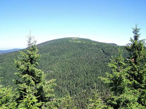
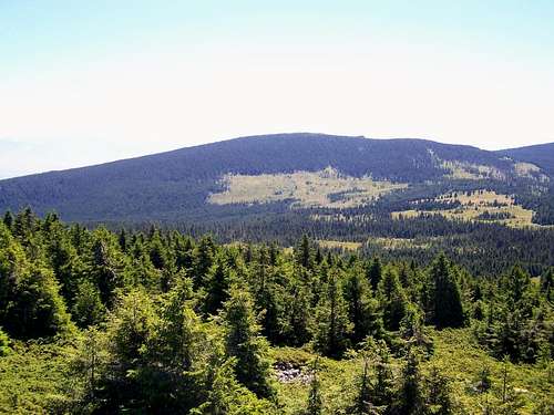
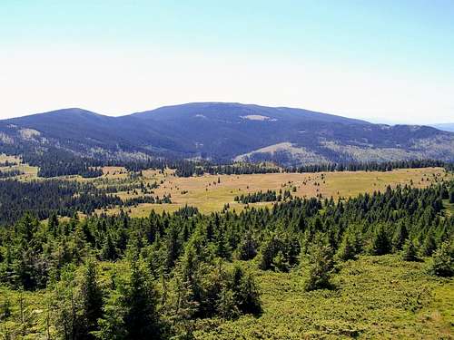
But let’s return to our subject – to the mountain itself. In the Eastern Carpathians there is a mountain range called Harghita/Hargita, and also several summits in its central part that are all called various “kinds of Harghita/Hargitas”. The range itself is 70 km long and 20-25 km wide. The mountain range is divided into 3parts: a northern, a central and a southern part. The central block is the highest. I will focus on this area on this SP page.
The central mountain range has distinct borders to the northern and to the southern mountain ranges. It stretches from the saddle called Fertau/Fertő on the north to the saddle called Tolvaios/Tolvajos on the south. These two saddles are 15 km far from each other. The highest peaks of the mountain range emerge here. While the mountain range is considered as the largest andesite mass and the largest volcanic body in Europe, the centrally located highest peaks are remnants of the huge cone of a stratovolcano. These peaks are the following: Vf. Mihaihovos/Mihály-havas (1685 m), Harghita Mădăraş/Madarasi-Hargita (1801 m), Harghita Racu/Rákosi-Hargita (1758 m), Harghita Siculeni/Madéfalvi-Hargita (1710 m), Harghita Ciceu/Csicsói-Hargita (1755 m) and Piatra Altarului/Oltárkő (1363 m). The diameter of the volcanic caldera was 6 km! This caldera was formed as the result of the exploded stratovolcano. This area was volcanically active up to the “latest times”: the last eruption was at the southern part of the mountain range approximately 20,000 years ago.
But let’s return to the main caldera! As time passes, a caldera loses its nearly perfect circular shape. One of the biggest factors is that the water inside the caldera finds its way out, and it cuts the rim of the caldera. The same happened here. The “delinquent” is the stream called Vârghiș/Vargyas. It’s a tributary of river Olt. The Harghita/Hargita mountains forms part of the watershed between Olt and Mureș/Maros. Streams on the northwestern slopes of the mountain are tributaries of Mureș/Maros. Though the source of these two rivers – Olt and Mureș/Maros – are only 10 km far from each other, a drop of water that starts its travel at the source of Mureș/Maros will meet it fellow starting its trip in Olt after flowing 1400 km!
You may have noticed the following peak names that I already mentioned. They are almost identical:
- Harghita Mădăraş/Madarasi-Hargita
- Harghita Racu/Rákosi-Hargita
- Harghita Siculeni/Madéfalvi-Hargita
- Harghita Ciceu/Csicsói-Hargita.
 Harghita Mădăraş Harghita Mădăraş |
 Harghita Racu Harghita Racu |
 Harghita Ciceu Harghita Ciceu |
These peaks are all named about the village nearest to them:
- Mădăraș/Csíkmadaras
- Racu/Csíkrákos
- Siculeni/Mádéfalva
- Ciceu/Csíkcsicsó.
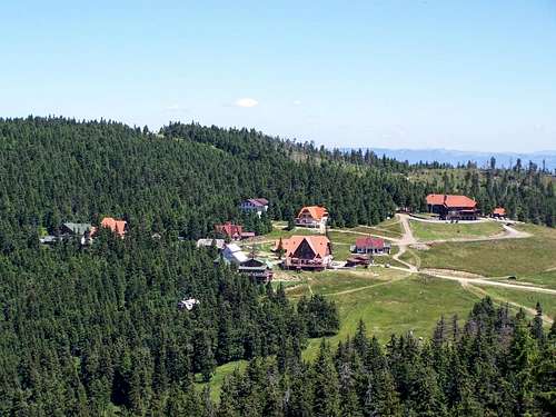
The first mountain resort and spa in the central area of the mountain range – called Harghita-Băi/Hargitafürdő – was founded in the 19th century Harghita-Băi/Hargitafürdő. It has carbonated water pits and sulfide gas thanks to the post-volcanic activities. In the years 1940-1944 the resort was used by the Hungarian military for training and for recreational purposes.
The first big mountain hut was built here not far from the summit of Harghita Mădăraş/Madarasi-Hargita in 1941, with the support of the Hungarian government. Since then a smaller mountain resort developed at this place. The two resorts are connected with a marked path (blue stripe). The resort are also connected with all neighboring villages. But hikers are less lucky when intending to visit the highest summits. There is no problem with the highest peak: Harghita Mădăraş/Madarasi-Hargita can be accessed easily on a marked path (blue triangle). But there is no trail to the next 3 highest peaks: to Harghita Racu/Rákosi-Hargita, Harghita Siculeni/Madéfalvi-Hargita and Harghita Ciceu/Csicsói-Hargita. And I don’t recommend you to leave the marked paths. Life danger! See the paragraph later about the bears! Still some lower peaks can be visited on marked trails. These are Cetatea Bufniței/Bagoly-kő (1679 m) and Muntele Ascuțit/Hegyes-kő (1570 m). And the peak of Mihaihovos/Mihály-havas (1685 m) can be accessed with ski lift in winter and on foot via the ski run in the other seasons. Because it’s also a smaller winter ski resort, with a total length of 4.5 km ski slopes of all difficulties. The ski season is from mid-December until mid-April.
Climate
The number of days without clouds is relatively low: 1600-1900 hours. Days with sunshine are the most likely between the 20th January and the 10th February. Another potentially clear period is between the 25th July and the 10th November. The average temperature on the hilltops is +2 Celsius degree. January is the coldest with an average -10 Celsius degree temperature. Freeze can be expected in any month except for August. It is the land of extremities. The temperature can be near -40 Celsius degree at the foot of the mountain in wintertime. And in summer – very rarely – the temperature can reach +36 Celsius degree temperature. It’s not just a legend. In August 2017 I was “lucky” to enjoy +35 C temperature on the hilltop.Flora and fauna. And bears
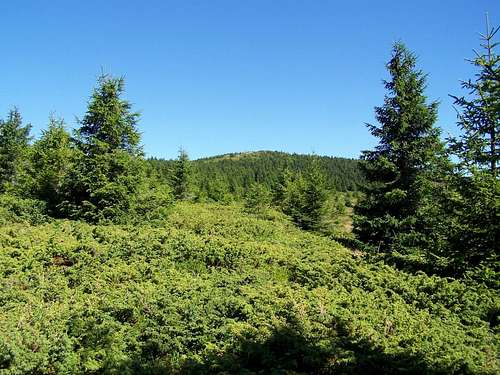
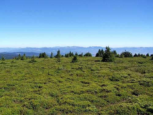
Below 900 meter altitude the slopes are covered with mixed forests or with beech forests. Above this level the mountain is covered with spruce forests. The hilltops have subalpine flora. They are either grasslands or they are densely covered with alpine juniper, with bilberry, with lingonberry or with bog bilberry.
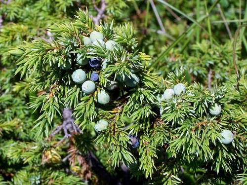 Alpine juniper Alpine juniper |
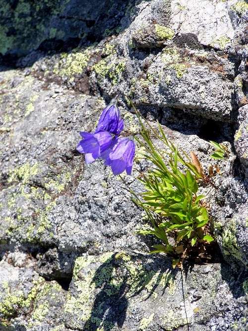 Bellflower on an andesite rock Bellflower on an andesite rock |
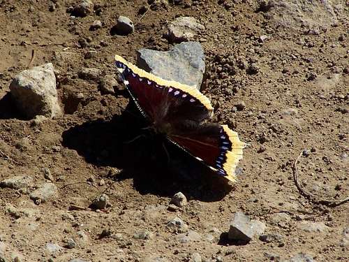 Camberwell beauty Camberwell beauty |
The fauna is mainly determined by the dominant spruce forests. What animals live here?
Typical amphibians and reptiles:
- Alpine ne
wt
![Typical subalpine flora on Mt. Harghita]()
Typical subalpine flora on Mt. Harghita - Carpathian newt
- viviparous lizard
- western capercailli
- tawny owl
- Eurasian eagle-owl
- common buzzard
- coal tit
- red crossbill
- spotted nutcracker
- hazel grouse
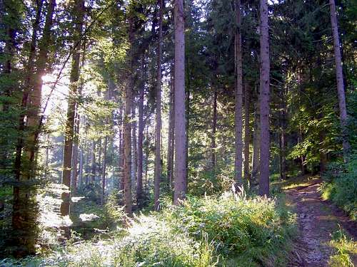
![The forest near ÅicasÄu]()
The forest near Şicasău
- red deer
- lynx
- grey wolf
- wildcat
- pine marten
- squirrel
- wild boar
- red fox
- and last but not least the most interesting animals here: the brown bears.
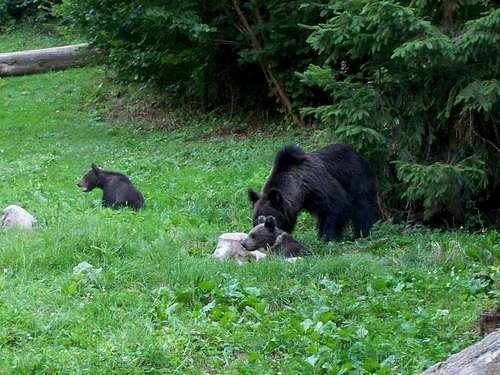 A mother brown bear and her two cubs A mother brown bear and her two cubs |
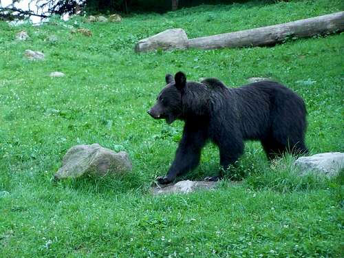 A young brown bear A young brown bear |
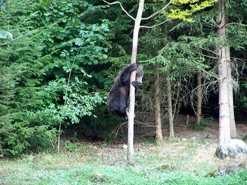 A bear climbing a tree A bear climbing a tree |
Harghita Mădăraş/Madarasi-Hargita
The mountain resort of Harghita Mădăraş
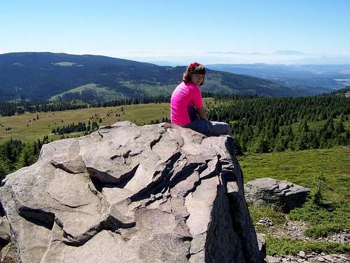
A good outlook point
The Southern Carpathians on the Horizon
THERE, WHERE THOSE FOUR RIVERS CHURN…There where those four rivers churn,Where pain's no burd'nThere where so much noble blood's been spilledThe wind speaks stories of a thousand yearsThe horn resounds upon the ancient fortOn Hargita honvéds reportAnd upon Erdély's holy heightThe Magyar Turul returns bright!There where those four rivers churn,Where pain's no burd'nLaughing over the fairy-like lakeThe sun can see her firey face.Where hymns resound, legends are born,Blown is the ancient, ferocious hornAnd upon Erdély's holy heightThe Magyar Turul returns bright!There where those four rivers churn,Where pain's no burd'nThere where so much noble blood's been spilled"Kolozsvár returns" the people singThe horn resounds upon the ancient fortOn Hargita honvéds reportAnd upon Erdély's holy heightThe Magyar Turul returns bright
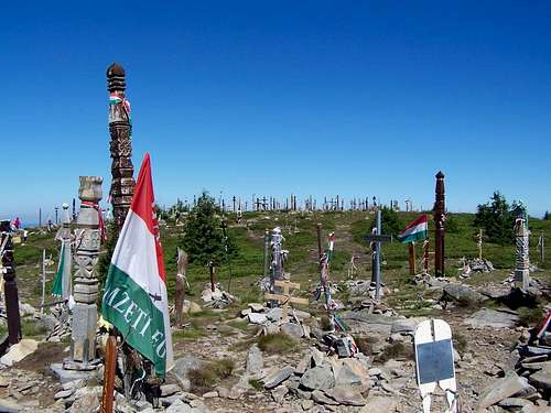 Monuments everywhere Monuments everywhere |
 No human intervention No human intervention |
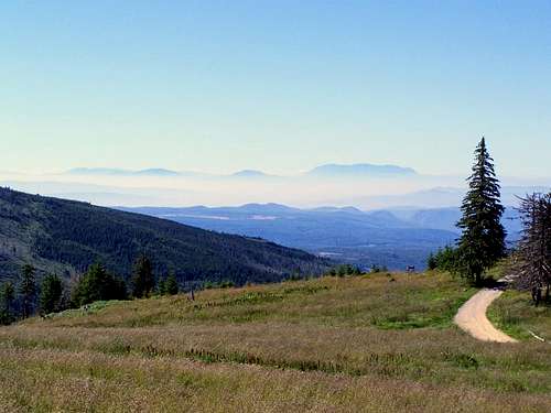
From here you can have free view on the Horizon, and in the not too far distance you can see the chains of the Eastern and Southern Carpathians. Let me mention some specific peaks: to the north there is Vf. Pietrosul Călimanilor/Nagy-Köves (2100 m) and to the south there is Omul (2507 m) and Moldoveanu (2544 m).
I don’t think that a mountain lover would consider this mountain as the most beautiful one. But I’m sure that anybody who visits it, will never forget it.
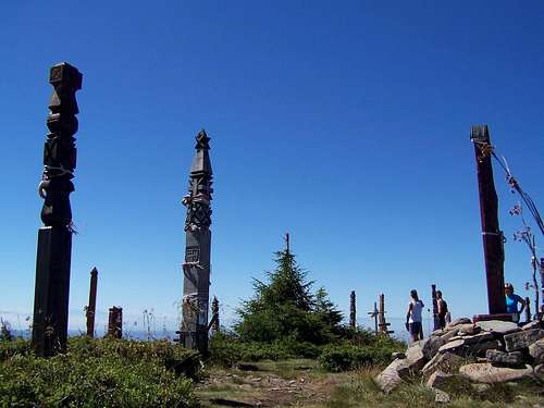 Monuments on Madaras Monuments on Madaras |
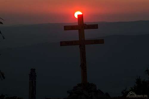 Madaras sunset - photo by Tomek Lodowy Madaras sunset - photo by Tomek Lodowy |
Normal route to the peak
The normal route to the peak starts from Cabana Harghita Mădăraș/Madarasi Hargita menedékház. It's a trail marked by blue triangle. It's short - only 1.6 km long - and not steep at all. 185 meter elevation gain that can be done by almost anybody. The bigger challenge is to get to the trailhead. Either you walk up there from one of the nearest villages. In this case the elevation gain will be minimum 1000 meter. Alternatively you can drive up to the trailhead by car. The forest road starts from the village called Izvoare/Ivó. It's 13 km long, and it has 3 sections with various quality: the first section has a relatively good quality macadam road. The second section is really bad. It can be passed by normal passanger cars, but you will be sorry for your car. The third section has a recently laid asphalt layer, and it's very good.
Useful link
At this link you can find a good map about the central parts of Harghita/Hargita Mountains
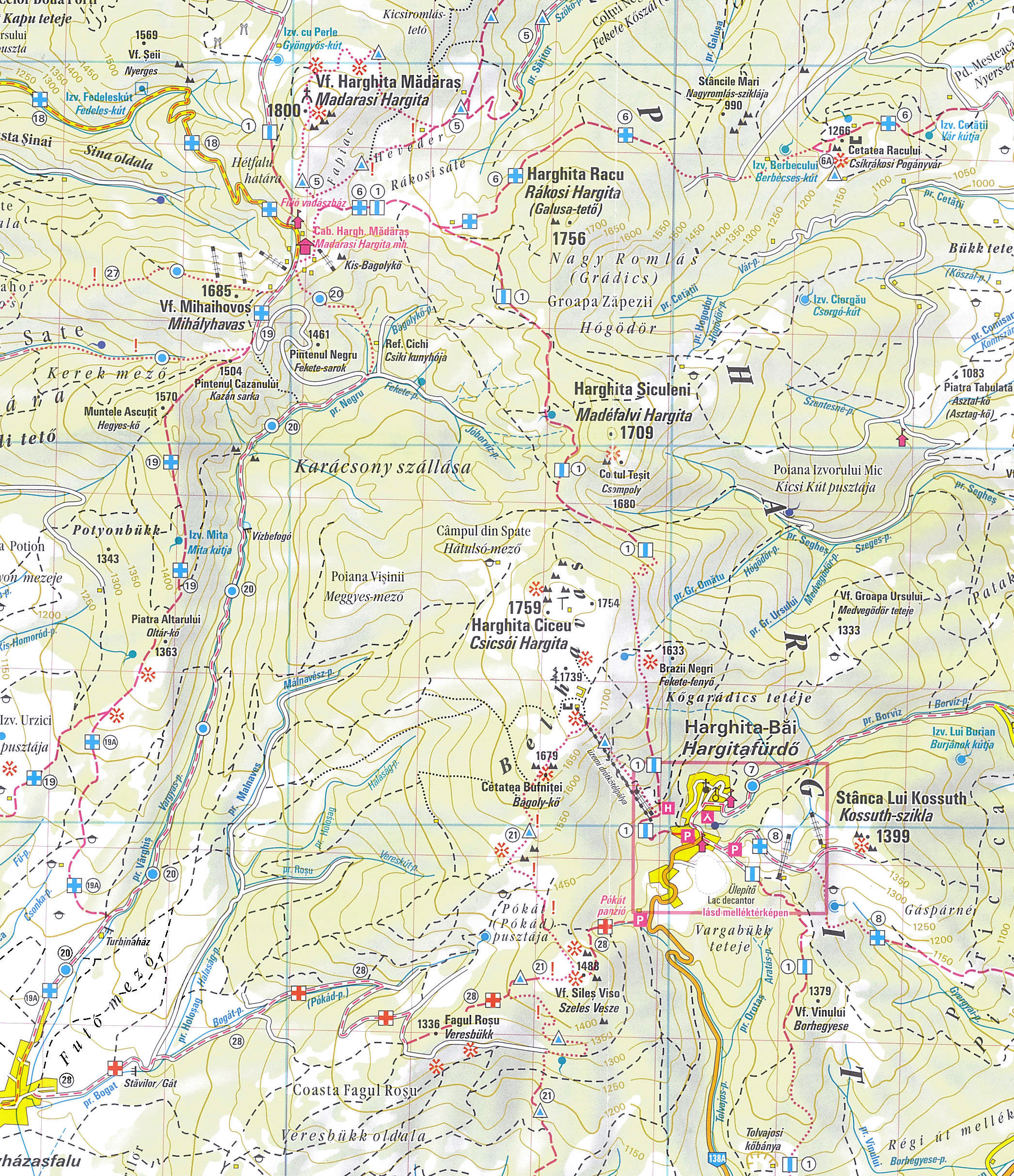
yatsek - Dec 4, 2017 9:13 am - Voted 10/10
Number of bears"6800 of them live in Romania. And 80% of this population lives in an area within a 70 km radius centered by the Harghita/Hargita mountains." I guess that's a mistake - probably about 20%: here and here. A map would be useful too. I've found a link to this map, which is old (from the communist era) but still shows the basics.
SzaniUherkovich - Dec 4, 2017 12:54 pm - Hasn't voted
Re: Number of bearsHi Jacek, I appreciate that you go into the details :-) Concerning the map, I will insert a link, following your advice. I know the internet source of a recent map, too. I don't want to upload the map directly, due to copy right issues. That's true that Hargita has 20-25 % of the total Romanian bear population. The trick is that the 70 km redius centered by Hargita Mountain does not equal Hargita County. This circle that has a diameter of 140 km covers Hargita County, Covasna County, the mountain covered part of Mures County, the north part of Brasov County, and the highest western parts of Neamt and Bacau Counties. As far as I know, this area really hosts 80% of the bears, since these counties are the most densely populated with bears. If the single Hargita county hosts 20-25%, then so many counties can host 80%. Does it sound reasonable? Cheers, Szani
yatsek - Dec 4, 2017 6:38 pm - Voted 10/10
Re: Number of bearsSzani, I'm afraid it doesn't. First, such a circle would cover less than 15% of all of the Romanian Carpathians and – according to this, I guess quite reliable data – may be home to about 40% of the Romanian bears. Second, why should we draw such a circle? It will be more informative to say that Hargita is the 2nd most densely populated by bears county in Romania (approx. 17 bears per sq km, while e.g. Vrancea or Hunedoara have half as many) plus perhaps insert a link to the interesting article I googled out thanks to your new, equally interesting Carpathian page. BTW I wonder why on earth Kovaszna and Hargita have so many bears. Are they the most wooded counties or are the bears Hungarian? :)
SzaniUherkovich - Dec 5, 2017 4:42 am - Hasn't voted
Re: Number of bearsHi Jacek. My numbers are not based on guesses, and they have nothing to do with interrelation between bears and counties with Hungarian population. Of course such interrelationship can't exist. This article is based on local Transylvaninan source: https://24.hu/kulfold/2017/09/03/tizedszer-tamadt-emberre-medve-az-iden-hargita-megyeben/. According to its last paragraph 78% of the bears of Romania live in the Counties of Hargita, Covasna, Mures and Brasov. I can't give an explanation why is it so. They are not the most wooded counties. Your source states 40% in the mentioned 4 counties, while the source that I referred states 78%. What can cause this conflict of data? Either incorrect numbers in one of the sources. Or the fact that your sorce is 23 years older than the source that I referred. Whatever the truth is, I can close the topic by changing the text on the SP page by stating that Hargitza County is the conty of Romania that is most densely polulated by bears
yatsek - Dec 5, 2017 6:59 am - Voted 10/10
Re: Number of bearsHoping you'll bear with me :) a minute longer: Agreed except that I'd write, "Hargita and Kovaszna, its southern neighbour, are the most densely populated by bears counties in Romania." As for reliability of the sources, bear in mind :) that the article I found was written by scientists, while yours by a journalist, I think mediocre or/and kind of sensation-seeking. 80% of the bears on just 15% of the Romanian Carpathian land is just not plausible. BTW Could you please give some info on the "normal route" to the highest summit? And there isn't any red tape, is there? Cheers, Jacek
SzaniUherkovich - Dec 15, 2017 3:34 am - Hasn't voted
Re: Number of bearsJacek, now I did the modifications that you suggested. Cheers, Szani
yatsek - Dec 15, 2017 11:15 am - Voted 10/10
Re: Number of bearsThanks!
yatsek - Jun 2, 2020 9:07 am - Voted 10/10
Some recent infoI thought you might like to add this info/link.
SzaniUherkovich - Jun 2, 2020 9:32 am - Hasn't voted
Re: Some recent infoThe question about bears in Harghita pops up again ;-) I inserted the link into the body of the main page. Thank you