
|
|
Mountain/Rock |
|---|---|
|
|
35.77987°N / 52.16017°E |
|
|
Mountaineering |
|
|
Summer |
|
|
12303 ft / 3750 m |
|
|
Overview
Click to see a Map of the Dobrar Ridgeline.Note About Elevation: The Iranian 1:50 000 Map only gives contour lines of 3740-3760 m for the summits of Parvaneh Peak. The 3750 m figure is per my GPS. Google Earth and all of the topographic maps that I have ever seen, give no hint of the existence of the high points to the east of Parvaneh. The elevation of Point 3905 m is per my GPS.
Note About Name: The term “Parvaneh” has been used in reference to different high points on the crest of the Dobrar Ridgeline. I think it is appropriate to use it for the double summit of Point 3750 m. Although lower than the high points to the east of it, Point 3750 m has much prominence making it a “true peak”.
Dobrar Ridgeline:
Dobrar (Ghareh Dagh) Ridgeline is an impressive 52 Km long mountain chain that forms a continuous wall in the southeastern portion of the Central Alborz Mountains of northern Iran. This ridgeline gives rise to more than 20 named peaks and many other unnamed high points. The elevations of 5 of these peaks exceed 4000 m. The highest of these peaks is the 4072 m summit of the West Dobrar Peak. The ridgeline starts near the Emamzadeh Hashem Pass on Haraz (Tehran-Amol) Road and heads east to end near the village of Seh Band on Firooz Kooh (Tehran-Sari) Road.
 Dobrar Ridgeline
Parvaneh Peak:
 From Lasem Village
 Parvaneh
Parvaneh is a double summit that rises in the western half of the Dobrar Ridgeline. To the west, Parvaneh is separated from the 3635 m Changiz Chal I Peak via a 3510 m saddle. To the east, a long series of high points (see below) connect Parvaneh to the 4020 m Angemar II Peak. The southern slopes of Parvaneh drop very steeply to the bottom of the Tar River Valley (2000 m) and its northern slopes go down to reach the Lasem River (2500 m). The two summits of Parvaneh have roughly the same elevation.
Parvaneh can be potentially accessed via its northern slopes (its southern slopes are wall-like just below the summit). Most climbers, however, reach Parvaneh as a part of a multi-day traverse of the Dobrar Ridgeline.
Point 3905 m & Other High Points to the East of Parvaneh:
From the summit of Parvaneh Peak, as you continue to hike east on the crest of the Dobrar Ridgeline, you will come across a large number of high points. While these high points do not have enough prominence to be considered individual peaks, they make the traverse of the ridge-top very time and energy consuming. Like most peaks of the ridgeline, the southern slopes of the high points are very steep, sometimes creating impressive walls just below their summits. The elevations of the high points gradually increase as you go from west to east. I have arbitrarily chosen Point 3905 m as the eastern boundary of the high points.
Route:
This route describes a traverse of the Dobrar Ridgeline from the 3510 m saddle between Changiz Chal I Peak and Parvaneh Peak to the summit of Point 3905 m. Click here and here to read about the Changiz Chal Peaks (and here to read about Bazm Chal Peak which is the usual access point to the top of the Dobrar Ridgeline).
Hiking Distance from Changiz Chal I to the west summit of Parvaneh: 2.15 Km
Hiking Distance from Changiz Chal I to Point 3905 m: 4.55 Km
In some places, the ridge-top can become narrow giving the hike an airy feel but in my opinion it remains a non-technical route.
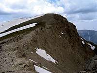
From the 3635 m summit of Changiz Chal I, hike down toward the 3510 m saddle. The twin summits of Parvaneh will be well in view:
 The double summits of Parvaneh, southwestern face
Hike up the ridge-top to the west summit of Parvaneh:
 Western Ridgeline Western Ridgeline | 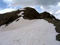 Western Ridgeline Western Ridgeline |
Views from the west summit of Parvaneh:
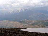 Damavand in Clouds Damavand in Clouds | 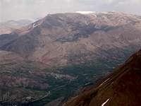 Pashooreh Peak Pashooreh Peak |
Descend a little to the saddle between the two summits of Parvaneh Peak:
 W face of E summit W face of E summit | 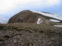 E face of W summit E face of W summit |
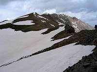
Beyond the East summit of Parvaneh, you will see a succession of high points going up toward Angemar II Peak:
 High Points
Hiking around some of the high points:
 High Points High Points |  High Points High Points |  High Points High Points |
Looking back (west) at the Parvaneh Peak:
 NE face of Parvaneh
The ridge-top becomes rocky with steep drops to the south:
 Ridgetop Ridgetop |  Ridgetop Ridgetop |
More high Points:
 High Points High Points |  High Points High Points |  High Points High Points |
Impressive walls to the south of the ridge-top:
 Wall Wall | 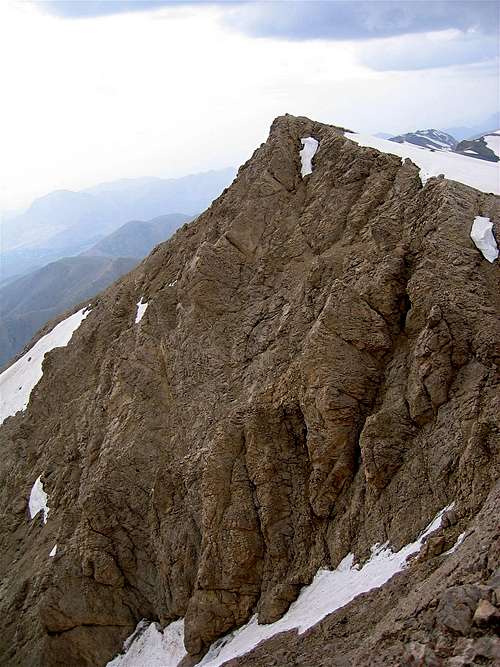 Wall Wall |
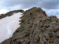
Narrow/airy feeling ridge-top:
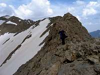 Ridgetop Ridgetop |  Ridgetop Ridgetop |  Ridgetop Ridgetop |
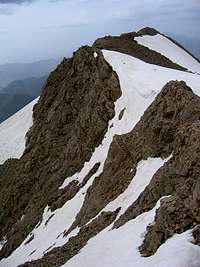
Point 3905 m, west face:
 Point 3905 m
Views from the top of Point 3905 m:
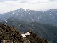 Zarrin Kooh Zarrin Kooh |  Looking South Looking South |  Looking West Looking West |
Point 3905 m, east face:
 Point 3905 m