
-
 5039 Hits
-
 82.48% Score
-
 15 Votes
|
|
Mountain/Rock |
|---|---|
|
|
46.34864°N / 14.36318°E |
|
|
Hiking, Scrambling, Skiing |
|
|
Spring, Summer, Fall, Winter |
|
|
5627 ft / 1715 m |
|
|
Introduction
What's new here?
> May 28th, 2020: Štajnar trail described.
> Jan 24th, 2019: Design corrections.
> Aug 18th, 2017: Northern ascent on Kriška gora, a few pictures added.
> Dec 19th, 2015: Initial page setup.
Initial statement
This page was created because the page of Storžič, which has been on SP since 2002, became too big. As these are my home mountains, I want to describe them a bit more in detail.
Overview
 JFS - Tolsti vrh and Storžič
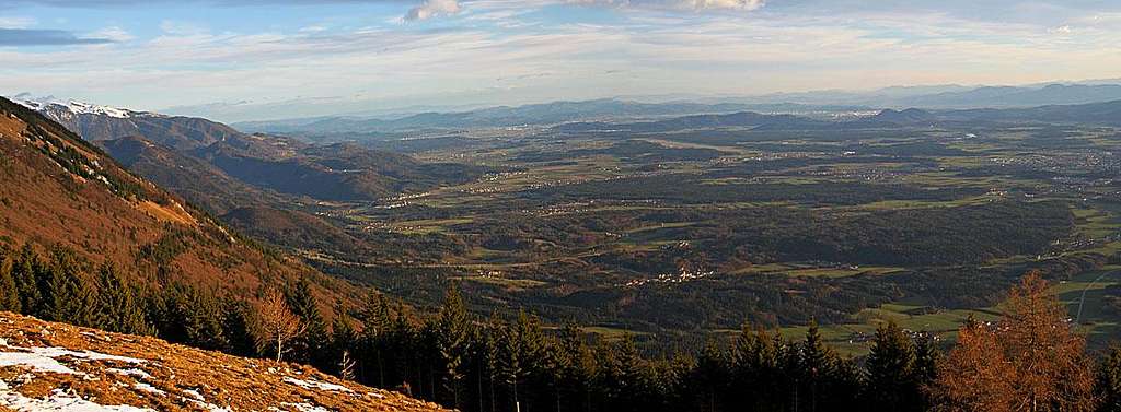
 Tolsti vrh and Zaplata from the N-NE
West of the dominant Storžič a not so high, but very popular ridge is stretching. It consists of the very distinct summit of Tolsti vrh (another name is also Zaloška gora) on the east and the grassy ridge of Kriška gora towards the west (also called: Kokovnica). Both summits have their names by the villages on the southern side of the ridge: Zalog and Križe. The popularity of this ridge can be attributed to the fact that these mountains (as the whole group of Storžič) are rising directly above the Gorenjska plane, so they are quickly reachable and they offer very nice panoramas around. On the northern side of the ridge there is a bit remote valley of Lom, separating our Kamnik and Savinja mountains from the Karavanke range further to the north.
Geography
On the west the ridge (and thus the whole Storžič group) rises from the valley of Tržiška Bistrica. There are the towns of Tržič and Bistrica pri Tržiču. In the lower part the slopes of the ridge are forrested and partly rocky, but in the upper part you can see characteristic grassy slopes. Nowadays they are a bit more ovegrown as in the past, when people used to cut the grass there and exploit those slopes. The northern slopes of the ridge are all covered with woods and in many places steep and rocky, especially in higher regions.
 Kriška gora from the east
After the ridge steeply rises above Tržič, there are two characteristic points: Mala Mizica, 766 m, and Velika Mizica, 976 m. They both offer some views around. More towards the east the grassy ridge soon gains the altitude of 1473 m, where we have the summit of Kriška gora. Just nearby it, there is the mountain hut - Koča na Kriški gori, 1472 m. Just south of Kriška gora and its hut, in the lower part of the ridge, there is a nice terrace with the village named Gozd, 897 m. From the valley (from Križe) a mountain road reaches there and so the village is one of the most popular trailheads for hikes on Kriška gora and Tolsti vrh.
 Vrata
VrataThe main ridge from Kriška gora towards the east is then gently, but constantly rising. A bit more towards the east there is the notch of Vrata, 1590 m. A promising name (meaning: door), but no really useful passage goes there over the ridge (it's possible to descend by screes). Further to the east there is finally the highest elevation of our ridge - Tolsti vrh, 1715 m. From its summit towards the south a rocky, quite steep side ridge descends. Its rocky middle part is called Štajnar. The main ridge of Storžič group however continues towards the E-NE. Also this one descends steeply on the distinct saddle of Mala Poljana. In the very eastern part of our ridge we have two distinct saddles with two nice alpine meadows: Mala (small) Poljana, 1327 m, and Velika (big) Poljana, 1410 m. On both there are huts - on Mala Poljana a hunters hut and on Velika Poljana a private (shepherds) hut. These two saddles are separating the groups of Tolsti vrh and Storžič. Between the two meadows there is a quite sharp and mostly overgrown peak, named Grebenc, 1479 m. Only from its summit rocks you have some nice views around.
What To Do There?
Tolsti vrh and Kriška gora are almost exclusively hiking mountains. The crags are not high and compact enough for climbing and the slopes are too overgrown for skiing. However tour skiing descents are possible, but not very popular. Additionally, Kriška gora is very popular as a starting point for paragliding and in the lower part there are also nice mountain biking and biking routes. In winter from below Dom pod Storžičem a nice sledge piste is arranged.
Summit views
On Tolsti vrh


Southern views
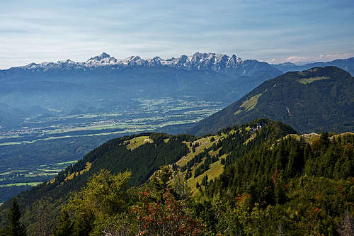
From Tolsti vrh we have excellent views towards the south, over Gorenjska plane (Upper Carniolia). More towards the west we see nicely Julian Alps with Triglav. The western and Northern horizon is showing the nearby Karavanke summits - Stol group and Košuta group. And very interesting is also the view towards the east, on the nearby Storžič.
Getting There
 Gozd village church
We can ascend on the ridge from almost all sides. The main trailheads, all reachable by car, are:
- Dom pod Storžičem, 1121 m. Standing above the end of Lom valley.
- Lom village, 696 m, Grahovše village, 800 m. For eventual northern ascent on Kriška gora.
- Tržič, 500 m. We can park by Sv. Jožef church, 577 m.
- Gozd village, 890 m. On the southern terrace. Reachable by car, but also by marked paths from the villages: Križe, Golnik, Svarje (above Zalog).
- Zalog village, 535 m. For the ascent over Mala Poljana.
- Above Povlje village, 710 m. For Mala and Velika Poljana.
Routes
All difficulty gradings are on the Swiss Hiking Scale (T1-T6). To zoom-in and zoom-out, you can also use the minimap in the corner right below.

1. Tržič - Kriška gora
From Sv. Jožef church above Tržič we follow marked paths and cart roads, ascending through the woods. The path soon becomes quite steep, leading us by Mala Mizica and Velika Mizica. The latter is a more nice viewpoint. Then the path becomes even steeper and only below the upper part of the ridge ascends more gently. Soon we see the first grassy slopes, from the right the path from Gozd joins (W variant) and we follow it on the final part of the ascent and to the hut. Easy (T2), 2 h 30 min.
2. Gozd - Kriška gora
 The S slopes of Kriška gora
The small village of Gozd, 890 m, can be reached by car, but from the villages below, at least 4 main hikes also ascend there. They are all easy (T2/T1):
- From Križe, 508 m, we mostly follow the mountain road towards the NE and E. The marked path only on a few places does shortcuts. 1 h 15 min.
- In Golnik, 490 m, we start the hike below the hospital, then pass its complex by the W side and continue by the marked path, ascending towards the N. The ascent goes by paths and cart roads. Some 15 min before the village, this trail passes a panoramic rocky edge, called Skalca. The route finishes by the Gozd church. 1 h.
- Between Golnik and Senično on the main road (410 m) an unmarked trail starts, going up by the forested ridge towards the N. It passes the hill where once a medieval tower stood (Gutenau), then it continues towards the NE and joins the marked trail from the hospital.
- The third option from Golnik starts at the highest farm (555 m) more towards the east. It's not marked and goes in turns up, first by a cart-road, then by weak trails. Left of the trail is the rarely visited Laznikova zijalka, a cave where traces of neolithic men were found.
- From Zalog, 535 m, we continue by the road to the nearby Svarje (620 m) and then by the last houses on a good, marked path. It soon gets on a cart-road, where we turn right, but the road does only a big turn. Soon the direction is again NW. After a few comfortable turns the road ends ('15). Next section is a bit unpleasant due to fallen woods, then we soon reach the plateau. Through a nice beech forest we come on the meadows of Gozd. 1 h.
Summit ascent: From the parking place in Gozd village (near the church) we continue in the northern direction. Two marked paths go towards the hut. They are broad and comfortable, in many gentle switchbacks they ascend through the woods. Below the hut they reach the meadows and ascend over them in additional few switchbacks. Easy (T2), 1 h 15 min.
 On Tolsti vrh W ridge
3. Kriška gora - Tolsti vrh
This is a very nice and panoramic part of the hike. The marked path goes mostly by the southern side of the ridge, but on some points it also goes by it and there we encounter nice scenery. From the mountain hut on Kriška gora we go in the vicinity of the main ridge towards the east. The path is very comfortable and gains altitude gently. Near Vrata the path goes by the ridge, then again by its southern side and later on the ridge again. The last part is steeper and the path more and more rocky. It can require some additional care if the terrain is icy, one short part of the ascent also goes by a more narrow ridge. But in good conditions the whole ascent is still easy. So we reach the fore-summit, descend a bit and then with the final ascent reach the highest point. Easy (T2), 1 h.
4. Gozd - Tolsti vrh

The crossroads is above the village, on the eastern side. While the marked path on Kriška gora goes straight up (towards the N), our route (inscription tells us that we have 2 h 15 min to Tolsti vrh) continues by a comfortable cart road, gently ascending towards the east. All its branches are well marked. Higher, from the cart road deters left a more and more steep path (named "Čez Ježo"), which later brings us out of the woods on quite steep grassy slopes. Crossing them is easy in good conditions, but take care if the slopes are covered with snow or icy! In the middle of those slopes there is a nice bench with a memorial plate (a 5-years old girl lost her life there). From there we keep continuing traversing the slopes and soon reach the edge of a high forest. There the path from Mala Poljana comes around the S ridge (Štajnarca), so we keep left up and continue ascending more steeply. Forested trail is becoming more and more rocky, on a few places there are steep ascent sections. Higher we gain the place where the view on Storžič opens, even higher on the ridge from the right another marked path joins (also from Mala Poljana) and we continue steeply up. Only just below the summit the ascent becomes more gentle again. Easy to medium difficult hike up (T2), 2 h 15 min.
|
 Tolsti vrh ascent Tolsti vrh ascent |
 Gaining the south ridge Gaining the south ridge |
This ascent, in combination with the descent by route #3, represents the most beautiful route on Tolsti vrh. The round tour is especially nice in the afternoon. We can even afford to wait for a sunset, as the descent from Kriška gora to Gozd is quick and short. The whole round tour can be done in 4-5 hours.

5. Štajnarca trail - around the S ridge
This trail has not much importance for those who attempt the summit ascent on Tolsti vrh. It just connects the village of Gozd and Mala Poljana meadow. Even if coming up from Mala Poljana, going on Tolsti vrh so much around the S ridge is not a good idea. But the trail is very beautuful - narrow, exposed, on three places secured with short cables (T3).
6. Tržič/Lom - Kriška gora
This is a rarely done acsent. In the upper part, the path is demanding (T4) and only poorly marked. In the lower part there are a few blue marks (hunters?), in the upper, rocky part, rare old, red marks are very welcome. The path mostly sticks to a distinct ridge and requires to overcome more steep, rocky sections, dangerous for sliding. Only on a few places there are old protection devices in a form of wooden poles, nailed on trees to form a kind of a fence. From Tržič town the tour lasts at least 15 min more than from the Lom village. Despite difficulties, this is an interesting tour, enabling also a round tour (in combination with descents by routes #1 or #7.
 Hunters hut
7. Grahovše - Kriška gora
Also this is a rarely done ascent on the main ridge from the northern side, done mostly by locals. We park in Grahovše village in Lom valley, 800 m. From there we go to the Hrib hamlet and further southwards. For orientation, hard is only the beginning. We stick to cart roads, but above the third meadow we deter right on the hunters path (first marked with white arrows and a few old red circles). The path is keeping towards the right, reaches in the vicinity of Mali and Veliki turn rocks, 1183 m, and steeply (a bit exposed, but the path is good and well beaten) further on to the hunters hut and far towards the right on the main ridge. Then right some 200 m to the hut on Kriška gora, which we reach in a few minutes. 2 h 15 min, T3. This route can nicely be used in combination with other routes to make a round tour. For example: From Tržič on Kriška gora (#1) and down by this route to Grahovše (where bikes should be waiting us). Or: By this route on Kriška gora, then by the main ridge further on Tolsti vrh (#3), then down on Mala poljana (#9) and further down to Dom pod Storžičem (#7), where bikes should be waiting us.
8. Grahovše - Tolsti vrh
Also this is a rarely done ascent on the main ridge from the northern side, done mostly by locals. We park in Grahovše village in Lom valley, 800 m. From there we go as on the route #7 to the Hrib hamlet and further southwards. The path is only at first weakly marked, later we deter left and follow an even weaker, unmarked path, which gets lost on a distinct, steep scree field, falling down from below Vrata notch. The last part of the ascent on the ridge is steep and tedious. After reaching the ridge marked path, we continue left on top. 3 h.
9. Dom pod Storžičem - Mala Poljana
From Dom pod Storžičem, 1121 m, we continue by mountain roads and cart roads towards the SW (on your risk also by car), or following the marked path to Mala Poljana. We reach the saddle and the meadow beyond it in some 45 minutes (road: easy, T1, marked path: T2). The road is suitable for mountain bikes - but the last 150 m of altitude are really very steep. Still, if you are returning here into the Lom valley, it's worth preparing bikes as high as possible.
10. Povlje - Mala Poljana
 Approaching Povlje
 Mala poljana
The alpine meadow of Mala Poljana can be easily reached also from the south (but the ascent is longer). From the parking place above Povlje village, 710 m, we go by the left road first to the nearby creek, then to a quarry, after which the road turns into a cart road. Soon the marked path leaves also the cart road, deterring right. It goes first above a distinct ravine and then crosses it. On the ridge, ovegrown with nice pine trees, from the left the marked path from Goriče/Zalog joins (from the left). That one starts in Zalog, 535 m, and is some 20 minutes longer, going from the church towards the NE. On the place where both paths join, there is a nice view point and nearby also a bench. The continuing goes by a marked path, which follows a quite distinct ridge towards the north. This is still the joint path on Velika and Mala Poljana. But just a few minutes higher the path branches. For Mala Poljana we go left, the path leads us into a distinct valley below Tolsti vrh. The valley is mostly overgrown and the ascent is not the nicest one. Also the path gets weaker. Through the most narrow part of the valley we ascend into its upper part, where we later reach a deteriorated cart road, by which we get out of the woods on the lower part of meadows. Soon we reach the hunters hut on Mala Poljana. Easy (T2), 1 h 45 min (from Zalog 2 h).
 Tolsti vrh above Mala Poljana
11. Mala Poljana - Tolsti vrh
From Mala Poljana two marked paths are ascending on the summit of Tolsti vrh. Both go (one above the other) first on the western edge of the alpine meadow and then across the steep, forrested eastern slopes of Tolsti vrh. The lower path, protected on a few places, reaches the southern ridge (Stajnar) quite low, then connecting to the marked path, coming up from Gozd (route #4). The upper path is a bit more direct, steeper, but also easier. After reaching the southern ridge, we turn right and as described in #4 continue quite steeply on top. Easy to medium difficult hike up (T3, mostly T2), 1 hour.
12. Povlje - Velika Poljana
From the parking place above Povlje village, 710 m, there are two marked paths on Velika Poljana. The right (eastern one) is called also Dolenčeva pot and is less attractive. In the recent years the forrest around that path was mostly destroyed and everywhere we see ugly forrest roads, cutting the slopes. The western path is however very beautiful, although not much panoramic. It follows a distinct ridge, which is a natural southern continuation of Grebenc ridge.
a. Dolenčeva pot. On the parking place we already leave both roads and continue by a marked path northwards. It goes through the woods and by forrest roads. On the altitude of some 1000 m the path to Velika Poljana continues left across the slopes, while the path to Javornik meadow continues straight up (the crossroad is well marked). So we go left, following mostly forrest roads. They bring us on a distinct ridge, where from the left the western path joins us. There is a big turn and we continue again northwards. When reaching below Velika Poljana, we leave the cart road and continue the ascent over the meadows. The hut is standing on the upper part of the meadow, on the eastern side. Easy (T1), 2 h.
 Velika Poljana ascent
b. Western path. As described in #7, we go by the left road first to the nearby creek, then to a quarry, after which the road turns into a cart road. Then we continue till the branching on some 850 m. There we choose the right path which nicely ascends by a distinct ridge. It is forrested, but with many switchbacks we quickly gain altitude. In parts the path is a bit steeper, but still no difficulties. Even if the ridge is south oriented, the ascent is not hot. Above, the woods are even more dense and so we reach the eastern path just on the big turn. Then to Velika Poljana as described above. Easy (T2), 2 h. From Velika Poljana we can go on Mala Poljana by a comfortable shepherds path, connecting both meadows by crossing the northern slopes of Grebenc. 15 min.
13. Grebenc
 Storžič from Grebenc
 Resting on Grebenc
The ascent on the hill of Grebenc is not someting special. That small rocky peak is certainly not an independent goal, but if from Mala or Velika Poljana we don't intend to go higher, we can ascend there. Its summit rocks can be reached only by a weak hunters path. From Grebenc we have some nice views, a broader wiew opens from a balcony just south of the summit rocks. The ascent on top goes from the upper edge of Velika Poljana Meadow (only 70 m of altitude difference). Either we follow a weak path or go up steeply by the NE slope. Grebenc has 3 small summit bumps. The first two offer only limited views, the highest rocks are more panoramic. Then we best continue by the ridge southwards. The descent is on places very steep, and also a bit exposed. So we reach the weekend hut near the southern ridge and from it return on Velika Poljana. Medium hard hike (T3), this small round tour can be done in good 30 minutes.
14. Hikes up to Gozd village

As said, Gozd can be rached by car, but the marked hikes from the villages below are also nice. They will all take you good 1 hour. From Križe you go eastwards, from Golnik (hospital) northwards and from Svarje northwestwards. In addition to marked trails, there are also many dirt roads and unmarked paths.
Let me mention here one more feature, which you may also want to visit. That's Laznikarjeva zijalka, a 47 m long and 12 m deep cave, which is also an archaeologic site (neolithic fireplace and bones of cave bear were found there). Not much can be seen there nowadays, though. The cave can be easiest reached from Golnik. We drive up to the last farm NE of the village and from there continue by a dirt road towards the NW. After a sharp turn right we switch to the NE direction, pass by a small quarry and continue until the cart road turns down. There we leave it and go left up, following a weak, ex dirt road. It goes across the slopes towards the left and ends some 20 m below the cave (altitude: 745 m).
Mountain Huts
 Kriška gora sunset
Around and on the ridge of Tolsti vrh and Kriška gora we find the following mountain huts (official and private ones):
- Dom pod Storžičem, 1121 m. Reachable by car.
- Zavetišče v Gozdu, 897 m. Reachable by car.
- Koča na Kriški gori, 1472 m. Reachable in 1 h 15 min.
- Mala Poljana hunters hut, 1327 m. Reachable in 30 minutes.
- Velika Poljana hut, 1410 m. Reachable in 45 minutes.
As in some other huts in the neighbourhood, also the huts of Kriška gora and Velika Poljana have their members club. The "Friends of Kriška gora" and "Friends of Velika Poljana" are registering their visits and thus maintaining their small competition in this sense.
When To Ascend?
 Main ridge in winter
 The view from Kriška gora
On Tolsti vrh and Kriška gora we can ascend almost any time of the year. Some parts of Tolsti vrh ascent routes are steep and in hard winter require appropriate equipment. When there is a risk of avalanches, only the ridge route from Kriška gora can be recommended.
Outside links
Buy Now Storžič Group e-book.