
|
|
Mountain/Rock |
|---|---|
|
|
46.37669°N / 14.57860°E |
|
|
Hiking, Mountaineering, Trad Climbing, Ice Climbing, Mixed, Scrambling, Skiing |
|
|
Spring, Summer, Fall, Winter |
|
|
7228 ft / 2203 m |
|
|
Overview
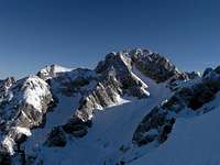
Mrzla gora is one of the summits of the central group, to the N of the range.The first ascent of this "last big problem" of the Kamnik-Savinja Alps was made in 1877 by J.Frischauf, Matek and Piskernik.
Mrzla gora still has the reputation (among mountain hikers) of being a difficultly accessible mountain. Both marked paths are of course secured, but only scarcely in their summital part: one of the paths reaches the summit along the west ridge and the other path (rarely done) along the east ridge.
Mrzla gora is a massif more than a mountain, and its ridges are made of named summits. The rugged (no path) north ridge between the Bela valley and the Matkov kot valley comprises Krnička gora (2061 m), Matkova kopa (1957 m), Matkov Grintovec (1711 m), Jerebičje (1761 m) and Pavličeve stene (1528 m).
Mrzla gora means "Cold mountain" (Kaltenberg in German), maybe due to the mainly northern orientation of the Bela valley and of Matkov kot.
Vellach/Bela valley
 Above the Vellach/Bela valley
Logarska dolina valley
 Above the Logarska dolina valley
> The standard ascent of the mountain is done from this side.
The many gullies (up to 600 m tall) are often ascended in winter, some of them even offering alpinistic ski possibilities. The lower part of the wall (close to the Okrešelj hut) is made of excellent quality rock and received many routes in the snowless months.
Matkov kot valley
 Above the Matkov kot valley
Matkov kot (the stream is called Jezera) is one of the upper Savinja valleys, the westward-most one (next to Robanov kot and Logarska dolina).
Only very few alpine climbs were put up from this side, and the marked and secured mountain-hiking path along Matkov kot may be difficult in terms of orientation, as well as daring in its summital part along the east ridge.
> An interesting feature in the upper part of Matkov kot is Matkov škaf (Matek's tub), a snow formation appearing due to water dripping on the névé from an overhanging wall above it.
Getting There
Logarska valley: start from the Okrešelj hut (Frischaufov dom)Matkov valley: click the coords in the primary info for road numbers. Along road 428 (12) between Luče and Vellach, follow the signs for Matkov kot, West of the road entering the Logarska dolina valley.
Vellach/Bela valley: click the coords in the primary info for road numbers. Along road 82 between Voelkermarkt and Kranj, follow the signs for Paulitsch sattel, above Bad Vellach. Next follow the sign for Vellacher Kotschna.
Red Tape
Unless signalized (barrier, signpost), and upon your own responsibility, macadamized roads are allowed and visible on maps (these roads are mainly maintained for lumbering and hut cable station access purposes).Fishing & hunting is regulated.
Wild camping and open fires are not allowed.
The Kamnik-Savinja Alps are part of the Natura 2000 program.
Austria: Vellacher Kotschna protected area rules.
Camping
LučeVoelkermarkt
External Links
Slovenske stene Slovene walls, by Tine MiheličZimski vzponi Winter ascents, by Grega Kresal
Mountain hiking guide Alpine Association (PZS)
plezanje.net Mrzla gora S face pages
Logarska Dolina Western Part climbing guide (also including the Matkov Kot valley)