
|
|
Area/Range |
|---|---|
|
|
43.20000°N / 19.10000°E |
|
|
8278 ft / 2523 m |
|
|
Durmitor National Park
"Among the mountain giants of the south-Slavic countries, the most powerful and most magnificient is Durmitor."
Kurt Hassert, German geographer, (Montenegro, Volume 1: Travels)
"Među planinskim divovima južno-slovenskih zemalja, najmoćniji i najveličanstveniji je Durmitor."
Kurt Hassert, nemački geograf, (Crna Gora, Deo I: Putovanja)
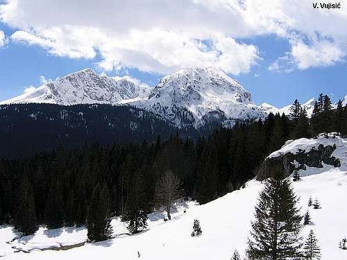
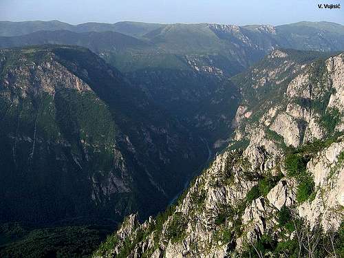
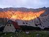
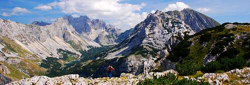 Durmitor from Raklje viewpoint
 Bobotov Kuk (2523 m), Đevojka (2440 m) and Minin Bogaz (2387 m) from Šareni Pasovi (2248 m)
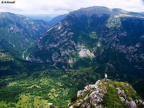
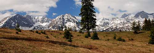 DURMITOR massif from Pitomine vasty plateau
 Rbatina (2401 m), Bezimeni Vrh (2487 m), Bobotov Kuk (2523 m), Đevojka (2440 m) from Planinica (2330 m) summit
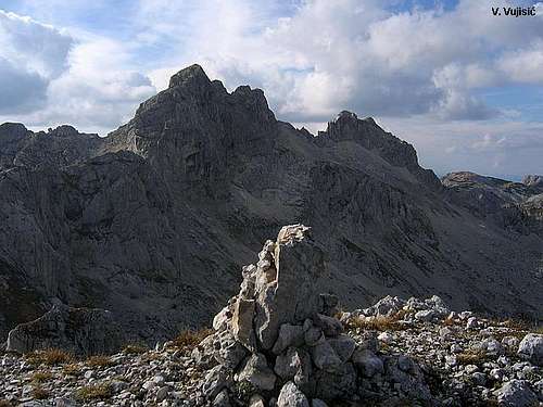
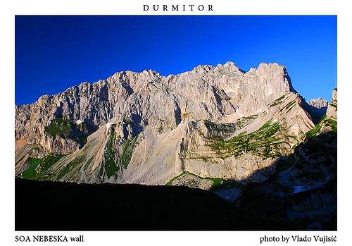
 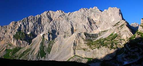 SOA NEBESKA wall – Bezimeni Vrh 2487m, Bobotov Kuk 2523m and Đevojka 2440m
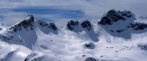 Minin Bogaz (2387 m), Lučin Vrh (2396 m) and Bobotov Kuk (2523 m) from Čvorov Bogaz (2152 m)
  Šljeme (2455 m), Terzin Bogaz (2303 m), Milošev Tok (2426 m) and Bandijerna (2409 m) from Čvorov Bogaz (2152 m)
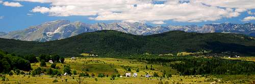 Panorama of DURMITOR massif from Žabljak-Đurđevića Tara road
DURMITOR is heavenly mountain! Paradise for mountaineers and nature lovers. Amazing and impressive beauty of Durmitor is simply breathtaking. Durmitor is really God's gift to the world! More than a mountain!
"Durmitor is the most beautiful mountain range of Montenegro", said Branislav Cerovic - mountain writer, great knower and devoter of Durmitor, who marked its whole massif.
Here in the heart of Europe, in Montenegro, you can find Tibetian, Mongolian, Alps and Colorado Canyon atmosphere, sceneries and panoramas. All these quallities on just one place! Durmitor is really so rich with its diversities that everybody who will visit it will have unforgetable experience and impressions.
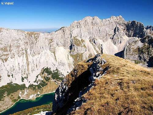
 Škrka Lakes Valley, most beautiful corner of DURMITOR
 Panorama of DURMITOR
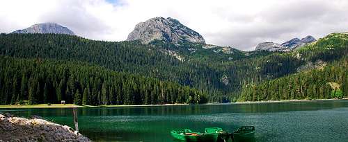 Emerald beauty of Crno Jezero (1416 m) lake, famous symbol of DURMITOR National Park
 Crno Jezero lake surrounded by black pine forest and Savin Kuk peak
 Panorama of DURMITOR with reflection of Medjed peak in the puddle
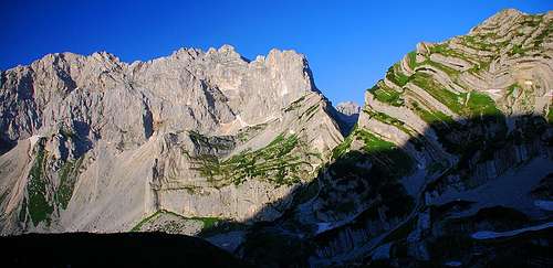
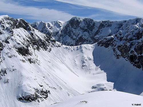
 Impressive 800 m high wall called SOA NEBESKA, the group of the highest peaks of DURMITOR
Some, especially Montenegrins, say that Durmitor is also most beautiful and most natural mountain range in whole former Yugoslavia.
Durmitor is second highest mountain range of Dinaric Alps, behind Prokletije mountain. With Slovenian Julian Alps, Prokletije and Komovi, Durmitor belong to group of most beautiful mountain ranges of former Yugoslavia.
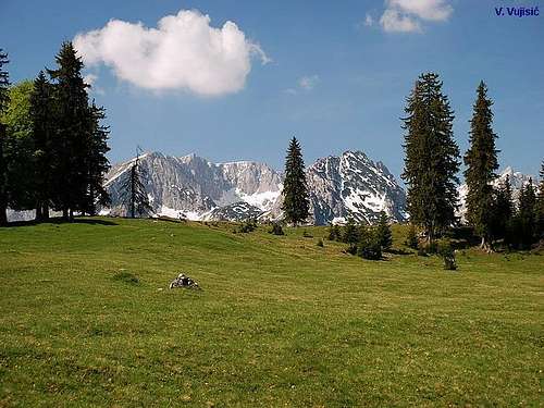
 Magnificent DURMITOR
 Impressive winter outlook of Durmitor
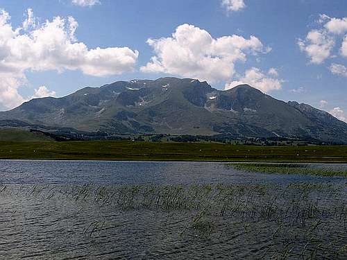
This beautiful mountain range is situated in the north-western part of Montenegro. Durmitor National Park is surrounded by deep valleys and canyons from three side - on the N by second deepest canyon in the world and deepest in Europe - Tara river canyon, on the W by incredible canyon of Piva river and Pivska Planina mountain, and on the S by Komarnica river canyon. On the E Durmitor is open to huge vast plateau (grassland) called Jezerska Povrs (Plateau of Lakes), which end is on beginning of Sinjajevina mountain. Whole national park is 39.000 hectares big.
The main features of the Durmitor region is a Jezerska Povrs vast plateau 1500 meters above sea level intersected by deep canyon gorges over towered by impressive mountain peaks - 48 of which are over 2000 m (27 over 2200 m). Highest peak of massif is Bobotov Kuk (2523 m).
 Durmitor from Ivan Do
 Minin Bogaz & Lucin Vrh & Bobotov Kuk
There are 18 glacial lakes at heights over 1500 meters adding great charm to the Durmitor massif. Durmitorians called them "Gorske Oci" (Mountain Eyes).
Also, Durmitor have 748 springs of pure mountain water and forests in which some trees are more than a few hundred years old.
Along its 2000 km of climbing and hiking trails you can find many caves, such as Ledena Pechina (Ice Cave, below Obla Glava peak) and cave on Vjetrena Brda.
 The beauty of DURMITOR from Prutas (2393 m) balcony
 Alpine scenery of Bosaca village
 Eastern Durmitor
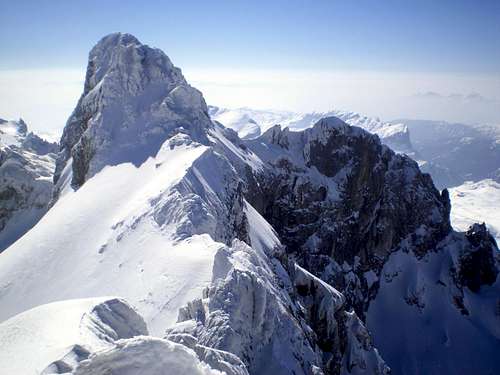
 Durmitor in winter
Among the most beautiful features of the National Park are the sparkling waters of the rivers, carved into amazing canyon valleys.
The Tara River is exceptionally beautiful, by its impressive currant, depth&landscape of the canyon, making it one of the most stunning in the world.
The richness of its flora&fauna, the complexity of its ecosystems, with over 1300 varied plant species, making it an exceptional concetration of such a quantity & quality of numeruous endemic & ancient species, that Durmitor has extraordinary natural wealth that is a permanent inspiration to scientists & nature-lovers alike.
The origin of the name "Durmitor" is not cleared with any certainity. According to some the origin of the name is romanic. Possibly it is derived from the latin word "dormitorium" i.e. from the italian word "dormitorio" or "dormire" - meaning "sleeping" because, according to legends the soldiers of the roman legions, marching by, were asking "is this Mountain sleeping?"
 Magnificent beauty of Durmitor
 Beautiful Durmitor from Pitomine vasty plateau
Of course, there is a far less romantic explanation, possibly much closer to the truth, that the name was given by celtic tribes, the celtic: "dru-mi-tor" meaning "water from the mountain". In any case the name was inherited by slav tribes coming into the territory: the locals are stressing the word "DURMITOR" on the second syllable.
Durmitorians called Durmitor mountain as "SOA NEBESKA". Meaning - Durmitor peaks are so high that touch the sky, stands as some kind of "Altar of the Sky".
 Beautiful atmosphere from Pitomine plateau
 Sareni Pasovi - Unique and recognizable trademark of DURMITOR
 'Tibetian' Durmitor
 Bezimeni Vrh 2487 m
Starting from the natural wealth and from specific values, in the framework of The National Park Durmitor there are seven districts which are especially protected, as follows: primeval juniper and pine forest in the confluence of the Mlinski potok (Mlin brook); the black pine complex in Crni podi in the Tara canyon; Crno jezero (The Black Lake) with its forest just nearby; the Skrcka jezera (Shkrchka lakes) valley and the nearby territory of the Susica canyon Barno jezero (the Barna Lake) with its nearby territory; the Zabojsko jezero (Zaboj lake) with its nearby territory, and the canyon-like valley of the Tara River.
The natural beauty and treasures of Mt. Durmitor & the Tara river were twice awarded international confirmation. In the framework of the Project "The Biosphere and Man" the Tara River was 1977 inscribed into the ecological biosphere reservation, thus being internationally protected by internationally adopted Conventions.
 Amazing beauty of Skrka Lakes Valley
The Durmitor National Park was in 1980 proclaimed world’s natural good and was inscribed into the Register of World’s Natural Heritage which is part of the UNESCO.
 |  |  |  |  |
Durmitor massif
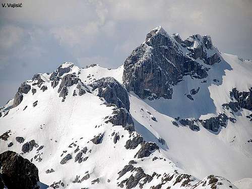
 SOA NEBESKA wall (Bezimeni Vrh 2487 m, Bobotov Kuk 2523 m, Đevojka 2440 m) and Šareni Pasovi (2248 m)
 Panorama of DURMITOR from Žabljak town
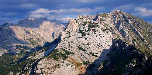 DURMITOR massif from Raklje summit
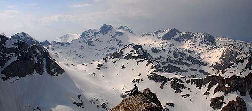 Central part of DURMITOR massif from Šljeme
 Velika Previja Pass, Bobotov Kuk, Bezimeni Vrh, Velika Struga Pass from Valoviti Do
 Međed (2287 m) and Savin Kuk (2313 m) from Terzin Bogaz (2303 m) ridge
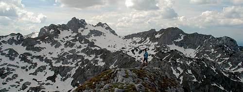 DURMITOR massif from Terzin Bogaz (2303 m) summit
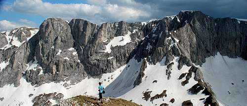 Šljeme (2455 m) massif from Terzin Bogaz (2303 m)
 DURMITOR massif from the North, from below Crvena Greda
 Šljeme (2455 m), Milošev Tok (2426 m) and Bandijerna (2409 m) from Mala Previja (2200 m) pass
 Bobotov Kuk (2523 m) and Bezimeni Vrh (2487 m) from Šljeme
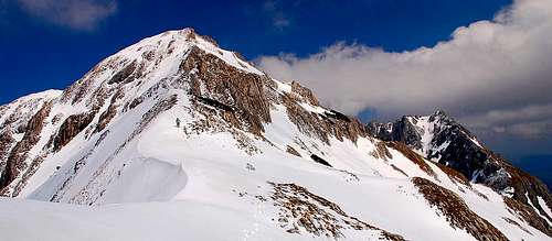 Terzin Bogaz (2303 m) and Međed (2287 m) from Mala Previja (2200 m) pass
 DURMITOR massif from the south from Burućkovac
 Durmitor massif from Bandijerna (2409 m) summit
Mountain peaks and sides were formed by withdrawing glaciers, leaving behind them moraine wrinkles and numerous lakes.
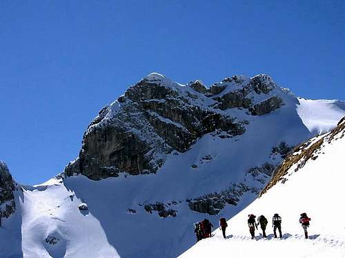
The Durmitor massif offers ideal conditions for mountaineering.
In this area, powerful tectonic forces created a mountain world adorned with extraordinary shapes.

 Bobotov Kuk (2523 m) & Bezimeni Vrh (2487m)
The jagged peaks, resemble other Alps as their names imply: Minin Bogaz (dagger), Zupci (saw teeth), Sohe & others; with massive domes & wide expanses with patterned sides called Prutash (plaid), Shareni Pasovi (colorful belts); or dressed in vertical stripes like Medjed (bear fur), Savin Kuk (hip) & Shljeme (roof ridge); or glowing colors like Crvena Greda (red rafter) or even those resembling saddles; Sedlena Greda (saddle frame) & Uvita Greda (bent frame); or Obla Glava (oval head); or even Stozhina (haystack pole). These are all frightening, dark or bright, little or gargantuan - the best marked mountain in this region is a virtual paradise for all mountaineers & mountain lovers.
 Minin Bogaz (2387 m) through the Samar pass
 Durmitor's massif
 Above Lokvice Valley
 Obla Glava (2303 m)
 Durmitor massif
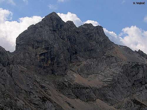
From all peaks of Durmitor massif three are most visited and most popular for climbing - Bobotov Kuk (2523 m), Prutas (2393 m) and Medjed (2287 m). Medjed (2287 m) summit view is something special. From the top of Medjed peak you can enjoy in amazing view to whole massif of Durmitor, above wonderful, impressive and deep Lokvice valley. Also, you can see Crno Jezero (Black Lake) like 'from airplane'. The best view to Crno Jezero is from Mali Medjed (2223 m) summit. Prutas (2393) summit view is really incredible. Beauty of this view is simply breathtaking. From Prutas summit you can see main crest of Durmitor massif (Soa Nebeska), which include three peaks - Bezimeni Vrh (No Name Peak, 2487 m), Bobotov Kuk (2523 m) and Soa or Djevojka (2440 m), above amazing incredible beauty of Skrcka Lakes Valley - God's gift to Durmitor, Montenegro and whole world. Also, beautiful Susica Canyon you can see. If you are visiting Durmitor don’t miss Prutas!!! From Bobotov Kuk (2523 m) summit - highest peak of Durmitor, you can see in good weather conditions many mountain peaks (in few countries), far some hundred kilometers.
 Minin Bogaz (2387 m)
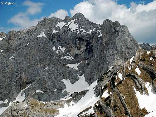
 Impressive massif of DURMITOR
Durmitor massif include about 50 peaks over 2000 m above sea level, or 27 peaks over 2200 m.
Here is the list of the highest ones:
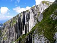 Vertical sedimental layers of Prutas (2393 m)
 Below Minin Bogaz
01) Bobotov Kuk (2523m) - highest peak of Durmitor
02) Bezimeni Vrh (Nameless Peak, 2487m)
03) Šljeme (2455m)
04) Istočni Vrh Šljemena (East Peak of Sljeme, 2445 m)
05) Soa or Djevojka (2440m)
06) Milošev Tok (2426m)
07) Bandijerna (2409m)
08) Rbatina (2401m)
09) Lučin Vrh (2396m)
10) Prutaš (2393m) - best viewpoint of Durmitor
11) Minin Bogaz (2387m)
12) Planinica (2330m)
13) Kobilja Glava (2321m)
14) Savin Kuk (2313m)
15) Šupljika (2310m)
16) Zupci (2309m)
17) Obla Glava (2303m) - with "Ice Cave" below peak
18) Terzin Bogaz (2303m)
19) Gruda (2302m)
20) Međed (2287m) - view to massif and Crno Jezero
21) Suva Rtina (2284m)
22) V.Previja (2255)
23) Štit (2248m)
24) Vjetrna Brda (2231m) - deepest cave on Durmitor
25) Sedlena Greda (2227m) - "Saddle of Gods"
 Bezimeni Vrh (2487 m)
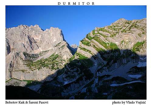 Bobotov Kuk & Sareni Pasovi
 |  |  |  |  |
Bobotov Kuk (2523 m)
 SE side of Bobotov Kuk from Surutka Valley
 Bobotov Kuk from Šareni Pasovi
Bobotov Kuk (2523 m) is the highest peak of Durmitor mountain and officially also highest peak of Montenegro. "Lord of Durmitor" dominates over entire Montenegro.
Location: Its rocky pyramid is placed in the central part of the mountain - in the middle of the main crest called Soa Nebeska, which stretches in NW-SE direction.
 Bobotov Kuk (2523 m) and Djevojka (2440 m) from Bezimeni Vrh (2487 m)
 Bobotov Kuk from Milošev Tok
 From Lucin Vrh
 From Medjed
From three sides its neighbors are very attractive and equally sharp and wild rocky peaks. Two of those three peaks are in main crest (Soa Nebeska): on the NW is Bezimeni Vrh (2487m), while on the SE is Lucin Vrh (2396m), which is separated from Bobotov Kuk by deep Velika Previja pass (2351m). On the SW, separated by amazing Skrcki Pogled pass, is Soa or Djevojka (2440m).
 Bobotov Kuk from Skrcko Zdrijelo (2114 m) pass
Western face of Bobotov Kuk is most impressive. Together with Bezimeni Vrh (2487 m) and Djevojka (2440 m) peaks, Bobotov Kuk, which is between them, create biggest wall of Durmitor. It is around 400m high and almost 2 km wide, above amazing beauty of Skrcka Lakes Valley - most beautiful part of Durmitor.
 From the slopes of Zupci
 From Čvorov Bogaz
To climb this peak is not only a trophy in your mountaineer’s booklet but also a soul-searching adventure in experiencing the diversity of this mountain’s beauty. This particularily applies climbing this peak from the north side, from Zabljak town. Right from the foot of the mountain you’ll pass through a primeval forest in the middle of which thrones the Crno Jezero (Black Lake).
After climbing a steep incline on the bottom of an ancient glacier you will reach the "katun" (a mountain cottage cum sheep-pen) Lokvice. From here, right over the Biljegov Do and the glacier circ Valoviti Do you will see the giant glacier circ of Skrka (read Shkrka), 800 m deep. From here, it will take you some twenty minutes to reach Bobotov Kuk summit (2523 m).
 Approaching Bobotov Kuk from Valoviti Do basin
 Bobotov Kuk from Terzin Bogaz (2303 m)
Summit view: View from Bobotov kuk is something you will never forget: if the weather is favorable to you it is possible to see few hundred kilometres afar – from the Rudnik, Zlatar and Zlatibor mountains on the N, to the Orjen and the Adriatic Sea in the S, from Kopaonik, Sinjajevina, Bjelasica, Komovi and Prokletije on E to Maglic, Bioc (2397 m), Volujak (2336 m) and Cvrsnica on W. Very special is the look onto the wreath of Montenegro mountains which are deeply cut with brooks and beautiful canyons, as well as the frozen surf of Montenegro mountains nearby.
 Bobotov Kuk (2523 m)
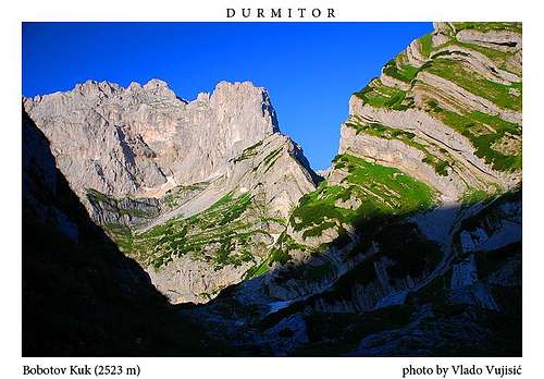
The sight from Durmitor gives you the best impression of this mountain’s creation. A very special sight is also to the Skrcka Lakes Valley and to the two beautyful lakes in this valley, as well as the fantastic figures of Sareni pasovi , basin Zeleni Vir (2028 m) - highest glacial lake of Durmitor, Minin Bogaz (2387 m) peak, the incredible Zupci ridge and the panorama of the Valoviti Do valley, right over whom you may, weather permitting, see the Crno Jezero (Black Lake) and the surrounding country. This one-day excursion you’ll never forget : it will indelibly be imprinted into your memory for all times to come. The climbing route till Bobotov Kuk summit is marked for 5.30 hours. For whole route you will need 10-11 hours - from Crno Jezero (Black Lake) to summit and back to Crno Jezero. This is a classical route.
 Bobotov Kuk from the summit of Savin Kuk
 Summit view
 From Prutas
Short history: Of course, scientists came first to discover Durmitor massif. First of them was Amie Boue who wrote about geology of Durmitor in his book "Geological Excursion in Turkish Europe" in 1840m. But, the Austrian scientist Oskar Bauman was the first man, who climbed at Bobotov Kuk in 1883, called Cirova pecina ( Ciro`s Cave) in his text. In his work “The first step on Cirova pecina” he says:” There was a stony valley covered with snow, spreading on our east, while on the other side there was green scenery of Jezero (the Lake) greeting us. Here I left Djuro, who suffered from dizziness, and I went for climbing the main peak with one shepherd. He took his shoes off and walked barefoot. After one hour of climbing, we left the peak behind us and stepped at the crest between the Soa and Kablinova. We were looking at the valley we had visited yesterday, and at the Skrcko and Malo Jezero (the Little Lake) sparkling. They looked like dark blue eyes.”
 Bobotov Kuk from Trojni Prevoj (2245 m)
N 43°07' 40.7'' E 19°02' 25.6''
Mountains (Peaks)/ High/ Distance
1) Ljubisnja (Dernjacista Peak)/ 2238 m/ 21 km
2) Zlatibor (Crni Vrh Peak)/ 1496 m/ 75 km
3) Zlatar/ 1626 m/ 68 km
4) Bjelasica (Crna Glava Peak)/ 2139 m/ 52 km
5) Komovi (Kom Kucki Peak)/ 2487 m/ 72 km
6) Kapa Moracka (Lastva Peak)/ 2226 m/ 37 km
7) Vojnik (Vojnik Peak)/ 1997 m/ 22 km
8) Orjen (Zubacki Kabao Peak)/ 1893 m/ 74 km
 Bobotov Kuk (2523 m) summit panorama of DURMITOR
 Bobotov Kuk from its southern approach
 |  |  | 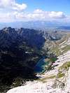 |  |
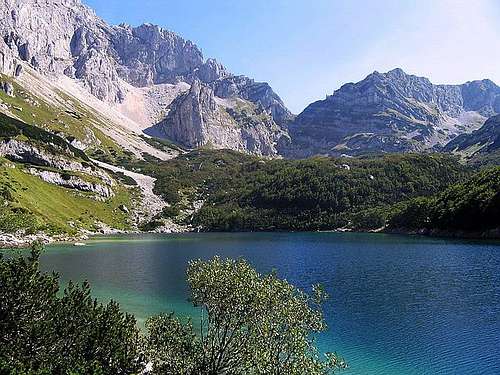
Durmitor Lakes - "Mountain Eyes"
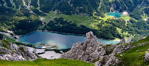 Škrčka Jezera lakes from Planinica summit
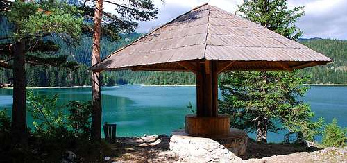 Kraljeva Stolica near Crno Jezero
 Škrčka Jezera lakes from Prutaš (2393 m) summit
 Crno Jezero lake and Crvena Greda (2175 m) peak
 Malo Škrčko Jezero lake
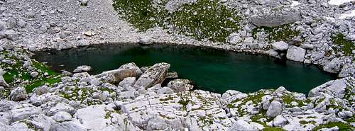 Zeleni Vir (Green Vortex, 2028 m) is the lake with highest altitude on DURMITOR
 Veliko Škrčko Jezero (1686 m) lake in Škrka Lakes Valley
 Crno Jezero from Medjed
After glaciation in last ice age, during melt of ice, Durmitor's lakes was born. Montenegrins and specialy Durmitorians call them Gorske Oci (Mountain Eyes).
They are located all over Durmitor mountain and Jezerska Povrs (plateau of lakes). These "Mountain Eyes" contributes very much to amazing beauty of Durmitor National Park. Durmitor's lakes are the trademark of Durmitor's famous beauty.
Durmitor have 18 glacial lakes at heights over 1500 m adding great charm to the Durmitor massif.
The foundation for scientific research of lakes on Durmitor was given in the far away year 1899 by Jovan Cvijic who, during his visit, called on all its lakes. He stated that this lakes left an indelible mark and are the element of recognition for this Mountain, because nowhere, in the whole wide world, there is no such abundance of lakes in such a small territory. Jovan Cvijic, Serbian great scientist called them, with every right, "MOUNTAIN EYES". All of this lakes are different according to magnitude, quantity of water in them, shape, origin, quality and beauty of landscape surrounding them, etc. If, however we look at them with our eyes, from our time, there can be no such thing as “to many lakes” and they are not given once for all times. This lakes are as beautiful as the water in them is clear and pure, because lakes, like people have faces and destinies. In the following pages you may read a story out every single one, because every single one is an “eye of earth”, and taken together they are MOUNTAIN EYES. Looking into them, we measure the depths of our souls.
 Skrka Lakes from Prutas
List of 18 lakes, according to altitude at which they are placed (in second brackets is their depth):
01) Crno Jezero (1416m) (49m)
02) Veliko Skrcko Jezero (1686m) (17.2m)
03) Malo Skrcko Jezero (1711m) (15.2m)
04) Zeleni Vir (2028m) (2.5m)
05) Jablan Jezero (1791m) (8.5m)
06) Valovito jezero (1695m) (3.5m)
07) Vir u Lokvicama (1693m) (4m)
08) Srablje Jezero (1623m) (2.5m)
09) Modro Jezero (1609m) (3.3m)
10) Suva Lokva (1593m) (2.5m)
11) Zminje Jezero (1520m) (7.7m)
12) Barno Jezero (1489m) (2m)
13) Poscensko Jezero (1487) (3.6m)
14) Zabojsko Jezero (1477m) (18.8m)
15) Vrazje Jezero (1411m) (10.6m)
16) Riblje Jezero (1409m) (5.5m)
17) Zminicko Jezero (1285m) (3.8m)
18) Susicko Jezero (1150m) (5m)
Only three kilometers from Zabljak, connected by a tarred road is situated Crno Jezero (Black Lake ), the biggest and the best known Durmitor lake, the second according to its surface among Montenegro mountain lakes, and one of the symbols of this parts.
 Crno Jezero (1416 m)
It is situated at the feets of the Medjed (2287 m) massif, who acts its guardian and protector, surrounded by dense connifers, which together with Medjed are looking into its blue-green surface. In spring-time, when snow melts, right on the side of Medjed a strong source Celina emerges sending a strong waterfall right into the lake.
 Incredible beauty of Crno Jezero (Black Lake)
The lake is made of two water-surfaces, Malo and Veliko jezero (Small and Big lake) separated by a narrow land strip called "Struga". The lake is 1416 meters above sea level. Malo jezero (Small Lake) is 49.1 meters deep, and Veliko jezero (Big Lake) is 24.5 meters deep. The temperature in the lake, during summer is above 22 Celzius degrees, making it a real heaven for swimmers, refreshment after peaks climbing.
 Crno Jezero (Black Lake) from ascent on Crvena Greda
 Emerald beauty of Malo Crno Jezero (Small Black Lake)
 Starting from Zabljak in the direction of Niksic, on the ninth kilometer of drive, easily discernible from vantage points is Vrazje Jezero (Devil’s Lake) – the cradle of winged horses. Its location is 1411 meters above sea level, its depth is 10.6 meters, it is largely open to sun rays, placed on the Jezersko-Drobnjak plateau, right beside the old caravan route which once upon the time was connecting Onogost-Niksic with Taslidzi-Pljevlja. The legend says that in the lake a winged red-coated horse is dwelling, which in starry nights comes out to graze, and to make love to mares which may be on its shores. After completing the love act, he kicks the impregnated mare in the side, wishing that the mare never may bring forth the result of the love act. Just once he was not successful, and the impregnated mare brought forth a winged horse Jabucilo which the famous Duke Momcilo was riding through the air from Pirlitor to Durmitor.
 Vrazje Jezero
 Riblje Jezero (Fish Lake)
 The caws in Riblje Jezero (Fish Lake)
Further down the road, some five hundred meters afar, is the Riblje Jezero (Fish Lake). This lake is situated on the plateau called Grcka Strana (The Grecian Side), 1409 meters above the sea level. This lake is 5.5 meters deep, and the name comes from its richness in fish, and this fish being especially big. According to folk talk, Italian carabinieri, who had a quarter in Zabljak once caught two brook trouts that were so long they were bridging the road across.
 Eastern Durmitor from Riblje Jezero (Fish Lake)
On the other side, on the south-east side of Durmitor where high mountains are gently sloping to the Lake plateau the Poscensko Jezero (Poscen's Lake) is located. The lake is 1487 meters above the sea level, and the lake is 3.6 meters deep. This lake has a glacier origin, and is located in the circ of the Poscenje village. This lake was very much researched by geologists. All visitors, passers by, writers and scientists were fascinated by its beauty and by the wonderful landscape surrounding it.
 Poscensko Jezero lake
The road taking you further into the stony landscape of Durmitor, you will meet the Modro Jezero (Blue Lake). Lake is situated at the foot of a Durmitor peak called Sedlena greda, 1609 meters above sea level, 3.3 meters deep. Looking into its water, you will clearly recognize whence its name comes. The waters of this lake abound in trout, and wild duck are often seen drifting.


A little further is Srablje Jezero. Possibly it is the smallest of the Durmitor lakes, its depth being only 1.5 meters. The Durmitorians often bath in this lake, assured that its water heal skin diseases, whence its name.
Right beside it is the Valovito Jezero. This lake too, is small, being 1695 meters above sea level, and 3.5 meters deep. The names comes from the Montenegro word "val" or "vao" meaning not "wave" but a territory with abundance of fallen rock.
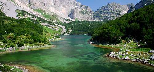
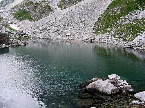
Still further, directing your steps to the central parts of Durmitor is the Skrka circ, the deepest and biggest on the Balkans peninsula. That for sure is a place you must visit if you want to feel the whole impact of Durmitor. Skrka is offering us two of its lakes: Veliko Skrcko Jezero (Big Skrcka Lake), by Jovan Cvijic also named "green lake".
 Skrcka Jezera from Skrcki Pogled viewpoint
 Skrcka Jezera (Skrka Lakes) from Planinica summit
This lake is situated 1686 meters above sea level, the maximum depth being 17.2 meters. The color of the lake is green indeed, being also limpid to 8.5 meters, this being the record among all Durmitor lakes.In the great Skrka Circ beside the aforementioned “Big” is also Malo Skrcko Jezero (Small Skrcka Lake ). This lake is situated at 1711 meters above sea level, the depth being 15.2 meters.
 Veliko Skrcko Jezero (1686 m)
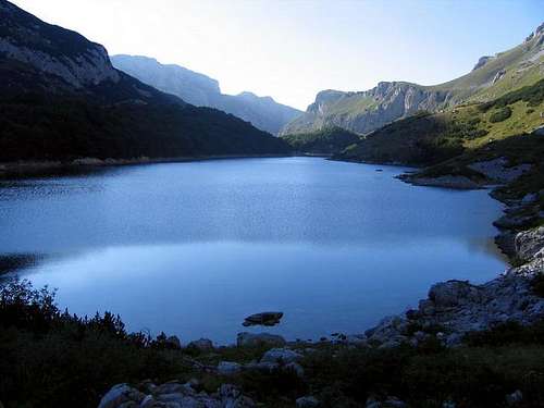 Evening atmosphere of Veliko Skrcko Jezero lake
A little further, in the direction of Nedajno village, in the extense of Susica canyon is Susicko Jezero. It is located 1140 meters above sea level and is a representant of Durmitors’ temporary lakes. The Susicko Jezero feeds itself on the waters of Susica river, this river having water only during spring months when snow is melting, the lake being visible only at that time.
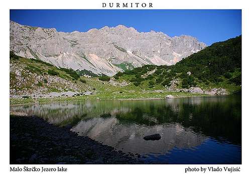 The highest peak of DURMITOR above the Malo Škrčko Jezero (1711 m) lake
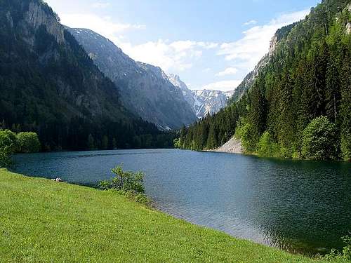 Susicko Jezero in Susica Canyon
Directing your steps to Zabljak passing by Mala Crna Gora village and the Stuoc peak at your left side, at the feet of Crvena greda, you will see Jablan Jezero (Poplar Lake), or Malo jezero (Small lake) the name some use. Although it carries such a name this lake is bigger and deeper (8.5 meters) than a lot of Durmitor lakes . This Jablan lake is situated 1791 meter above sea level, and its beauty honors Durmitor.
 Jablan Jezero (Jablan Lake) from ascent on Crvena Greda
A little lower of Jablan jezero, at the very source of Mlinski potok is Zminje Jezero (Snake Lake). This lake is deep in a forest and it compels you to lonesome thoughts about it. It is a smallish lake, deeply embedded into an oval of pine forest, thus being possibly the very true embodiment of the “mountain eye” looking through its conifer eye-lashes to the Crvena greda and nearby peaks. This lake is 1520 meters above sea level, and it is 7.7 meters deep.
 Zminje Jezero (Snakes Lake)
Very near, on the territory between Velika poljana and the Pitomina village on the east side, and the Bosaca village on the west side, situated 1489 meters above sea level is the Barno Jezero. This lake also is very small, the shores of which are overgrown with water vegetation, and a nearby pine forest. The villagers think that the waters of this lake are healing especially for skin diseases. In the pine forest it is said that flocks of mountain-goats are grazing. The lake is not deep, just one meter.
Very near Durmitor, on the Sinjajevina mountain, on the north slope there is Zminicko Jezero. This lake is situated 1285 meters above sea level, and the name comes from the name of the surrounding territory, called Zminica. Just by the shores of this lake the water is not very deep, 0.3 – 0.7 meters, but in the middle the lake is deeper, maximally 3.8 meters. In this lake all sorts of wild duck abound.
On the other side of Sinjajevina mountain, the Zabojsko Jezero is situated. The name is derived from katun (mountain stable/house) Zaboj, which was a very populous place during summer months when sheep were in the mountain for grazing. This lake is 1477 meters above sea level, and it is 18.8 meters deep.
 Emerald beauty of incredible Zabojsko Jezero lake
In this territory there are a number of temporary lakes, forming during strong spring rains. The best known is Sevarita Lokva. This hydrographical object is rather near to Vrazje jezero, and to Riblje jezero, and it strongly resembles them. This “lake” is not very deep – just 1 meter.
Nearby is Suva Lokva situated in Poscenska dolina, 1594 meters above sea level. This “lake” is only 1.8 kilometers from Poscensko jezero, and also is about 1 meter deep.
In the central parts of Durmitor, 2028 m above sea level is Zeleni Vir (Green Vortex), glacier lake with highest altitude on Durmitor. This lake is only one kilometer from the highest Durmitor peak, Bobotov kuk (2523 m), below his eastern crest.
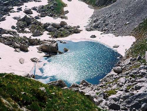 Zeleni Vir (Green Vortex, 2028 m)
His surounding is paradise for camping. Near is also water spring. Zeleni vir is 50 meters long, 40 meters wide, a 2 meters deep. Best time for visit this beautiful glacial lake is Jun and July, because at that time lake is full with water.
 Zeleni Vir (2028 m) lake (Green Vortex)
 |  |  |  |  |
Valleys of Durmitor
SKRKA LAKES VALLEY  |
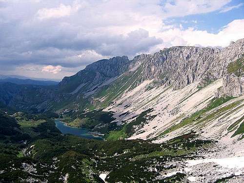
With it's two beautiful and picturesque lakes and impressive peaks which surrounded it's devine beauty, Skrka Lakes Valley is for sure the most beautiful valley of Durmitor. In the last Ice Age basin of Skrka was heavily glaciated and glacier was moving towards the canyon of Susica on the NW. Skrka occupies SW corner of central Durmitor. Valley is around 2.5km long while bottom is up to 1km wide.
 Skrka Lakes Valley from Samar pass
 Skrka Lakes Valley
From all but NW side, where opening of Susica canyon is (read Sushica), Skrka is closed by high and wild sides. And all three sides are specific, having different configuration. On the N & E is main crest of the massif. That side is between 600 and 800m high. The highest side of valley is about 800 m high wall of amazing Soa Nebeska crest, created by three peaks - Bezimeni Vrh (2487 m), Bobotov Kuk (2523 m) and Djevojka (2440 m), placed on N side of valley. Skrka Lakes Valley has two beautifully lakes: Veliko Jezero (1686m) (Large Lake) is placed in the middle of the valley. It is 580m long and up to 165m wide, 17m deep and has 1720m long coastline. Malo Jezero (1711m) (Small Lake) is rounded and located below the cliffs of beautiful Prutas (2393m). It is 225m long and up to 94m wide, 15m deep and has 440m long coastline. Between the lakes is grassy plateau on which Skrka Hut (1723 m) stands.
LOKVICE VALLEY
 Winter scenery of Lokvice Valley
Looking to the massif of Durmitor from Zabljak town, Lokvice Valley is second valley from the left, after Velika Kalica Valley. Lokvice are surrounded by many high peaks of Durmitor as are Bandijerna (2409 m), Terzin Bogaz (2303 m), Medjed (2287 m) and Cvorov Bogaz (2152 m). Through this valley leads many marked paths to main peaks of Durmitor. The bottom of Lokvice is split in two parts by the small hill.
 Lokvice Valley
North of it is Male Lokvice (Small Lokvice) while south of the hill is Velike Lokvice (Large Lokvice) with the Vir u Lokvicama (1693m) lake. On top of the hill is Lokvice Katun with few small shepherds houses, common place for camping. Lokvice is approached by marked path from Crno Jezero lake and from Ivan Do camp. At Lokvice Katun marks split as one path leads to Velika Previja pass (Medjed, Terzin Bogaz, Velika Kalica direction) while the other path leads towards Bobotov Kuk, Bezimeni Vrh and Minin Bogaz, going through Biljegov Do basin and Valoviti Do basin.
VELIKA KALICA VALLEY
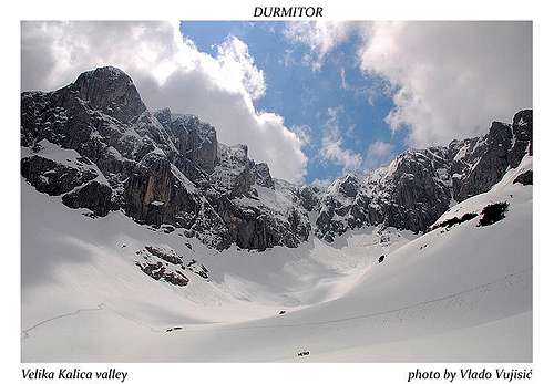 Velika Kalica valley from Struga pass
From all of valleys of Durmitor, Velika Kalica is most similar with wild high Julian Alps valleys. Bottom of this former glacial valley was most torn by its glacier. When you looking wild limestone cliffs of Sljeme, you can imagine that you are in Julian Alps. Like the nearby Lokvice valley, Velika Kalica stretches in S-N direction. On the E is Terzin Bogaz (2303m) - Medjed (2287m) crest, connected by Velika Previja (2145 m) pass.
 Velika Kalica Valley
From the S and E valley is closed by the huge wall of Sljeme (2455 m) which dominates on its SE side. On the northern end of the wall is Savin Kuk (2313m). Wall is between 300-400m high. On W side of Velika Kalica, belowe northern side of high Sljeme wall, large snow field or snow slope called Debeli Namet (Fat/Thick Drift) is placed, and that's the remnant of the former glacier. Valley is only open on the N where over Struga pass (1920 m) you can descent towards Crno Jezero lake. Marked path from Crno Jezero lake leads through Velika Kalica valley, from where you can climb Terzin Bogaz (2303 m), Veliki Medjed (2287 m) and Mali Medjed (2223 m). From Struga (1920 m) pass, which makes the beginning of the valley, marked path leads to Mali Medjed. At the end of the valley, on a small grassy hill by the Debeli Namet snow field, you can find a Bivak refuge (2020 m) (bivouac). From it the only way which going out of the valley lead to Velika Previja (2145 m) pass. From the pass marks go left to Terzin Bogaz (2303 m), right to Medjed (2287 m) or straight down into the Lokvice valley.
ALISNICA VALLEY
 |
Alisnica Valley is most western valley of Durmitor. Together with Dobri Do valley, Velika Kalica valley, Lokvice valley and Skrka Lakes valley, Alisnica contribute to amazing untouchable beauty of Durmitor. Alisnica Valley is placed in western part of massif. Long valley of Alisnica create two part of valley - Donja Alisnica (Lower Alisnica) and Gornja Alisnica (Upper Alisnica).
 Alisnica Valley
Whole Alisnica is very beautiful and has many breathtaking sceneries, for example a wild horses which running on green grassy plateaus of valley. Through Alisnica going marked path to Planinica (2330 m), Bezimeni Vrh (2487 m), Rbatina (2401 m) and Skrka Lakes Valley (1723 m). Bezimeni Vrh and Rbatina can be reached across Velika Struga (2274 m) pass. In any case, people mostly going through Alisnica valley to reach the summit of Planinica, which are one of the most beautiful viewpoint-summit of Durmitor. In Gornja Alisnica you can find Lokve ponds. Most impressive scenery from Alisnica valley is view to NW side of amazing Bezimeni Vrh peak and Velika Struga pass on it's left side. Sooner or later, you must visit that beautiful valley.
Durmitor Passes
ŠKRČKI POGLED (2420 m) Škrčki Pogled (2420 m)
At the edge of incredible beauty and amazing deepness of Skrka Lakes Valley (1686 m), belowe the southern impressive crest of Bobotov Kuk, near the ridge of Djevojka (2440 m), is located highest and for sure most beautiful pass of Durmitor - Skrcki Pogled (2420 m). This pass is placed 20 minutes away (by walk) from Velika Previja pass and across that pass leads marked path for last 100 high meters to summit of Bobotov Kuk. Also, Skrcki Pogled pass is famous and wide known viewpoint of the most beautiful corner of Durmitor - Skrka Lakes Valley and its two lakes. Of course, from that place you can enjoy in stunning view to large norhern face of Prutas (2393 m), nature miracle of sedimentary layers of Sareni Pasovi/Stit (2248 m), northern crest of Bezimeni Vrh (2487 m) and Planinica (2330 m), northern summit ridge of Djevojka/Soa (2440 m) and entrance of Susica Canyon.
VELIKA PREVIJA (2351 m)
 Velika Previja (2351 m)
Belowe NE crest of Bobotov Kuk (2523 m) is placed the second highest pass in Durmitor massif. That is Velika Previja (2351 m) pass. Actually, Velika Previja is located between two peaks, Bobotov Kuk and Lucin Vrh (2396 m), and proudly dominates above rocky sea of Valoviti Do (2027 m) basin. Across this pass leads marked path to Bobotov Kuk, Bezimeni Vrh (2487 m), Lucin Vrh and Djevojka (2440 m). Velika Previja pass is natural pass between southern and northern part of Bobotov Kuk massif. That high rocky pass is common place for take a rest before final climbing of Bobotov Kuk and visit of famous and breathtaking Skrcki Pogled (2420 m) pass/viewpoint. When you approaching Bobotov Kuk from the north, you must go across Velika Previja pass. Also, if you use northern descend from Bobotov Kuk, you will descend across this pass into Valoviti Do basin, towards Zabljak town. From that pass you need just 45 m to reach the summit of Lucin Vrh which is excellent viewpoint to amazing outlook of Bobotov Kuk.
VELIKA STRUGA (2274 m)
 Velika Struga (2274 m) pass, Bezimeni Vrh and Bobotov Kuk
 Velika Struga (2274 m)
Third highest pass in Durmitor's massif - Velika Struga (2274 m) is placed belowe impressive rocky north face of Bezimeni Vrh (2487 m) and belowe southern crest of Rbatina (2401 m), connecting the massifs of those two peaks. Velika Struga is natural pass between two valleys - Valoviti Do on the east and Alisnica Valley on the west. People mostly crossing that pass when climbing Bezimeni Vrh and Rbatina from Alisnica Valley or when they crossing that pass descending into Alisnica. Velika Struga pass is very impressive, specially its western side looking from Alisnica Valley. Standing on that pass, you can enjoy in nice view to western side of Minin Bogaz (2387 m), northern crests of Bezimeni Vrh and Bobotov Kuk, southern ridge of Rbatina and Valoviti Do (2027 m) rocky basin.
TROJNI PREVOJ (2245 m)
 Trojni Prevoj (2245 m)
Trojni Prevoj (2245 m)(Tripple Pass) is one of most impressive passes of Durmitor. Specially if you looking to Bobotov Kuk and its breathtaking eastern massif. Trojni Prevoj is natural tripple pass which connecting Surutka (2082 m) basin, Zeleni Vir (2028 m) lake and Lokvice Valley (1693 m). This pass is placed between SW side of Bandijerna (2409 m) and NE crest of Zupci (2309 m) peaks. Trojni Prevoj is nice starting point for final climbing of Bandijerna peak. Descend from Trojni Prevoj towards Zeleni Vir lake is unmarked path, but people also use it. View from this pass is beautiful in all directions. Most impressive is to Bobotov Kuk, and also to all other main peaks of Durmitor - Terzin Bogaz, Sljeme, Medjed, Minin Bogaz, Savin Kuk, Prutas, Bandijerna, Zupci, Sareni Pasovi... Also, Samar Pass (2075 m) is nicely visible with Prutas (2393 m) peak in the background. For sure, Trojni Prevoj pass is optimal place for perception of beauty of deep and long Lokvice Valley.
MALA PREVIJA (2200 m)
 Mala Previja (2200 m) pass
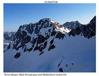 Mala Previja from Ledeni Do
Mala Previja (2200 m) pass is with its high altitude and beautiful position one of the most attractive pass in Durmitor. It is placed in the central part of Durmitor's massif and connects two valleys - Velika Kalica on NE with Ledeni Do on SW. Also, Mala Previja connects the massif of Sljeme (2455 m) with Terzin Bogaz (2303 m) peak. That pass is mostly more visited in winter, while in that time many climbers climb Milosev Tok (2426 m) peak from its northern side from Ledeni Do valley. Also, from Mala Previja you can climb Terzin Bogaz from its southern ridge. That route is very fine. Finally, from Mala Previja you can cross Ledeni Do valley and Suvo Lice (Dry Face) to reach Trojni Prevoj (2245 m) pass from where you can climb western side of Bandijerna (2409 m) or descend to Zeleni Vir lake or in Surutka Valley below the Zupci (2309 m) massif. Also, from Mala Previja you can descend to Velika Kalica valley where you can stay in shelter (capacity for 4 persons or maximum for 8 persons). Mala Previja pass offer outstanding view to whole massif of Durmitor and its highest peaks as are Bobotov Kuk, Bezimeni Vrh, Sljeme, Djevojka, Bandijerna, Rbatina, Milosev Tok, Minin Bogaz, Terzin Bogaz, Medjed and others. That pass is very unique place and deserve to be much more visited.
VELIKA PREVIJA (2145 m)
 Velika Previja (2145 m)
Another Velika Previja pass, but lower one then higher Velika Previja placed belowe Bobotov Kuk, is natural pass between Lokvice Valley and Velika Kalica valley, connecting those two valleys. Velika Previja (2145 m) also connecting S ridge of Medjed (2287 m) with NE ridge of Terzin Bogaz (2303 m). People crossing that pass before final climbing of Medjed and Terzin Bogaz peaks. From this pass you'll climb more about 150 m in height to reach those two summits. View from Velika Previja is amazing in all directions, looking to impressive deepness of Lokvice Valley or to Bobotov Kuk, Bezimeni Vrh and Minin Bogaz peaks in the background, or looking to impressive crests of Sljeme (2455 m) and Savin Kuk (2313 m) which proudly dominates above Velika Kalica valley. Of course, presence of two giants of Durmitor, Terzin Bogaz and Medjed is also very inspirative.
ŠKRČKO ŽDRIJELO (2114 m)
 Škrčko Ždrijelo (2114 m) pass
 Škrčko Ždrijelo (2114 m)
Škrčko Ždrijelo (2114 m) is for sure maybe the most beautiful pass of whole Durmitor. Also, from the effort aspect, that pass can be reached without any special effort. But, you should come in Dobri Do valley and follow road to Dobri Do (descending from Sedlo 1907 m pass) from where leads marked path to Skrka Lakes Valley via Skrcko Zdrijelo pass. This route is most easiest one from all routes of Durmitor. Also, the pretiest one! Skrcko Zdrijelo pass is placed between E side of Prutas (2393 m) and SW side of Stit/Sareni Pasovi (2248 m), connecting Dobri Do valley with Skrka Lakes Valley. From this pass you can witness most incredible scenery of Durmitor - Soa Nebeska wall, created by highest peaks of Durmitor, Bobotov Kuk, Bezimeni Vrh and Djevojka. Also, you can see Planinica (2330 m) southern side and Minin Bogaz (2387 m) through the Samar (2075 m) pass. From Skrcko Zdrijelo you can reach the summit of Prutas or just descend into Skrka Lakes Valley. Also, you have option to go via Samar pass to Zeleni Vir (2028 m) glacial lake. Sooner or later, don't miss to visit this beautiful pass.
SAMAR (2075 m)
 Samar (2075 m) pass from Planinica (2330 m)
 Samar Pass (2075 m)
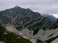 Šareni Pasovi (2248 m) & Samar
Samar (2075 m) pass is one of the most impressive and most beautiful passes in whole Durmitor's massif. Connecting beautiful Skrka Lakes Valley with Mlijecni Do basin and Zeleni Vir (2028 m) glacial lake, Samar pass is placed belowe SE crest of Djevojka (2440 m) and N sedimantary layers of Sareni Pasovi/Stit (2248 m). People mostly crossing that pass approaching to Bobotov Kuk and Zeleni Vir lake from Skrka Lakes Valley (western approach). Standing on this pass in the form of letter V, you can enjoy in amazing view to deep and long Skrka Lakes Valley, to high crests of Bobotov Kuk, Bezimeni Vrh, Djevojka and Prutas. Also, the entrance of Susica Canyon with Veliko Skrcko Jezero (1686 m)(Large Skrka Lake) in the foreground is nicely visible. Descending from Samar pass towards Skrka Valley you can stay in Skrka Hut (1723 m) which is placed on grassy plateau between two lakes of Skrka Valley.
STRUGA (1920 m)
 Struga Pass (1920 m)
Struga (1920 m) pass is natural entrance to Velika Kalica, Durmitor's valley which is most similar with deep and wild valleys of Julian Alps. That pass is placed below NW side of Savin Kuk (2313 m) and belowe SE crest of Medjed (2287 m). Also, Struga pass is nice viewpoint of Jezerska Povrs vasty plateau and the edge of Tara Canyon in the background. Across Struga pass leads marked paths to Mali Medjed (2223 m) and Velika Kalica valley. Also, Veliki Medjed (2287 m) and Terzin Bogaz (2303 m) can be climbed (via Velika Previja 2145 m). The view from Struga pass to impressive Velika Kalica is awesome, specially to northern high rocky massif of Sljeme (2455 m) and glacier Debeli Namet belowe. Savin Kuk (2313 m) and its western side is also beautiful.
SEDLO (1907 m)
 Sedlo Pass (1907 m)
In the Kingdom of South Durmitor, above amazing sceneries of Dobri Do valley, Sedlo (1907 m) pass is placed. On that place you can sometimes feel maybe the most powerful wind on Durmitor. Situated belowe N crest of Sedlena Greda (2227 m) and S side of Uvita Greda (2199 m), Sedlo pass is wide known viewpoint to endless Dobri Do and Todorov Do valleys. Here you can witness all beauties of South Durmitor, looking to impressive and unique Prutas (2393 m) peak and to incredible entrance of Komarnica Canyon, placed between crests of Lojanik and Boljske Grede. Looking to NE, you can see beautiful scenery of green Stozina (1908 m) peak with Valovito Jezero (1695 m) lake below. Also, you can enjoy in Suva Lokva pound and Ranisava peak. Across Sedlo pass going Zabljak-Virak-Trsa road. From Sedlo pass you can climb Sedlena Greda peak or approaching Bobotov Kuk via Uvito Zdrijelo (Uvita Greda). That's southern approach to Bobotov Kuk.
Tara Canyon
 Incredible deepness of Tara Canyon
In the surroundings of wonderful plunging into the abysses, bellow the steep slopes sometimes more of a thousand meters deep, cutting forcibly its very way between the Bjelasnica, Sinjajevina, Ljubisnje and Durmitor mountains, flows one of the most beautiful Montenegro rivers, the TARA RIVER.
Like a cut furrow between mountain peaks, the clear-water mountain river flows, and its very waters, from time to time make for wonderful landscapes in tame and fertile valleys in which acres, orchards, forests and meadows may be seen, with its flocks of sheep and goats, very often together with game graze. The river flows even further through the abyss, over it, on its stony slopes the lonely pines to skies pointing, which, the poet would say, from the very stone grow, the stone which plunges itself down, to the depths.
The river flows, like hiding from amorous looks regarding the cascades, the stones hidden well bellow, in the depths of the river waters, but, like many things hidden, seen because of its very clear waters. And so Tara flows, like looking for somebody innocent, like herself, to give herself to him. So beautiful, so clear all along its flow, forcing those in love with her to name her "TEAR OF EUROPE".
It is also called the "JEWEL OF EUROPE". With the length of 140 km Tara is longest river in Monte Negro. Tara river springs in Komovi mountains, near the border with Albanija, on the east of Monte Negro. It generally flows towards northwest. Its last 80 km, before it meets Piva river at Scepan Polje and they make Drina river, Tara spends in Europe’s deepest canyon, also called the "COLORADO OF EUROPE". On some places Tara canyon is 1300 m deep while below Veliki Stuoc (2104m) peak on Durmitor side of Tara’s canyon is 1600 m deep!
Crystal clear waters of Tara, which have light blue and green color, made its canyon in rough limestone mountains even before the Ice Age. Water has carbon dioxide in it which turns calcium carbonate into calcium bicarbonate that dissolves in water.
Tara got its name after Autarijati tribe of Illyrian people that lived here before Slavs came.
 View to Tara Canyon, 1000 m above Tepca Village
In the beginning Tara flows towards north, through gentle and fertile valley between Sinjajevina mountain on the west and Bjelasica mountain on the east. It passes through towns of Kolasin and then Mojkovac where it suddenly turns towards west-northwest. Some kilometers after Mojkovac, after the place where it is joined by Bistrica river, Tara enters its canyon which is a deep scar between Sinjajevina, Durmitor and Pivska Planina mountains on the south and Lisac, Obzir and Ljubisnja mountains on the north.
Tara, at its end making confluence with Piva, and giving birth to Drina, is some hundred and fifty kilometers long, and is the longest Montenegro river. In its part through Durmitor National Park, Tara has a mean fall of 3.6 meters/kilometer, making a host of waterfalls and cascades possible, thus creating with its uniqueness "Montenegrin Colorado".
All along its flow, Tara gets large quantities of water from numerous sources, and quite a few tributaries. The most important tributaries on the left Tara side are Ljutica and Susica, and the most important tributaries from the right side being Vaskovaska rijeka and Draga. The most important source is the source Bajlovica Sige, a source placed on the left bank of the Tara river giving to the Tara a few hundred liters per second, where the water sourcing from the Bucevica Cave falls into the Tara more than thirty meters high, and more than a hundred and fifty meters bright.
Very special are the Tara cascades. The roar from the cascades is heard on the very peaks of the canyon. There are more than forty cascades, the most famous being: Djavolje Lazi, Sokolovina, Bijeli Kamen, Gornji Tepacki Buk, Donji Tepacki Buk etc.
If you are visiting Durmitor National Park, don't miss Tara Rafting. That's a really amazing and unforgetable experience! You can choose from one, two, or three days of Tara Rafting. Only with rafting you can feel all beauty of Tara river play.
 Tara River - emerald beauty of Durmitor
Because of the quality of its water, and because of its unique ecological system, Tara in 1977 was put into the programme “Covjek i biosfera” (Men and Biosphere) and inscribed into the ecological biosphere reservations of the World, being thus protected under an internationally issued convention.
The flora of the Tara has right to this day many species of plant life saved from ancient times. What’s more interesting, many species have succeeded in guarding some of its primeval qualities, which were characteristic for times past. Thus, in the Tara valleys you can find some leftovers of the tercial flora right out of the last glacier period. Beside this flora, the plant life in the canyon is characterized by forests having very different species: cerris, ash tree, beech, black beech and birch.
Great parts of the canyon are overgrown with needle trees, a special place being reserved for the black pine. The most interesting specimens of the black pine are those which hang on naked stony slopes by its very roots, and thus hang over precipitous abysses. But, the most famous locality of the black pine is the locality where the black pine is part of the primeval forest, in a part of the canyon called Crna poda. The Crna poda are a very closely guarded natural habitat, a Natural Preserve on its own. Here some specimens of black pine may be found, some more than 50 meters high, some of which are more than 400 years old.
 Devine beauty of Tara Canyon
The massive of the canyon is a excellent habitat for the wild goat (rams). This very nearness of canyon and mountain gives the wild goat the possibility to seasonally migrate, in the winter from the cold peaks to the canyon, and vice verse, in the summer from the hot canyon to the lofty peaks. The wild goat, is, an inhabitant of lofty peaks and stony slopes, easily moving on stony places and mountain canyons. Beside the wild goat, as regular inhabitants of the canyon region there is the roe deer, and wild boar. The Tara is rich in fish species. In the river the brook trout may be found, huchen, chub, the clamp etc.
In the place called Djurdjevica Tara there is the great bridge, the building of which was started in 1938, and finished in 1940. This bridge in time became one of the symbols of the river. Disregarding that the bridge for sure was built by human hand, by its very beauty, by its noble lines, when looked upon from the lofty peaks its certainly looks like one of the Tara curves on its long journey to the confluence, it perfectly became part of the natural surroundings like the very bridge be built by Nature itself. During second World War the bridge was destroyed, like much else, but in the year 1946 it was rebuilt. The bridge is 154 m long, and at its highest bow it is 135 m above the banks of the Tara.
 Waterfalls in Tara Canyon
An excursion to the very precipitous slopes of the canyon is an adventure in its own right, the view is breathtaking. From this viewing places especially viewpoint Curevac (1625) is to be mentioned. From this viewing place on one side the panorama of Durmitor might be seen, and on the other hand the meandering flow of the Tara, among the stony peaks. From Curevac a wonderful look on the village of Tepca (more than 1000 m below) may be cast, with its houses and gardens, spread in an enlarging in the canyon. If on Curovac you hold your breath and listen carefully, you may hear the roar of Veliki buk, more than a thousand meters bellow. Its a place of very strong positive vibrations: you will leave content, happy and with an unforgettable experience. Nearby are Tmora a place only seven kilometers from Zabljak, a place you will reach walking through a wonderful primeval forest were you may hear the silence of the primeval peace and feel the perfection of the whole nature.
Your look will reach also wonderful, colorful villages, you may see ye olde bridges on the Tara, you may talk to the locals which will tell you the story of the cohabitation with Durmitor. But, above and beyond all: you will learn to respect and understand mother nature and its gifts.
All this beauties and celebrities of the "TEAR OF EUROPE" are nothing unless you once drink from the pure, cold and tasty Tara water, unless you hear the roar of Tara cascades, unless you look down to the very bosom of the Tara. If you live it through, you will eternally fall in love with Tara, always to return.
 |  |  |  |  |
Tara Rafting
 Rafting on Tara River
Only through rafting the true anatomy of the canyon may be discovered, and all of its handwriting. It is the only way to see what there is to be seen, the charm and the beauty of its abundance. Rafting may give to all this its special dimension, the very personal contact to the pureness of nature. Every new kilometer, even so a meter, all along the way, gives another hue, another sight-seeing, another challenge.
It is the most beautiful and the most attractive way to see and feel all this beauty and to enjoy in the well-being, the nature’s own way, created by Mother Nature.
The rafting attractions of Tara gained Mark 4, very near to the most attractive rafting-rivers in the world – like Colorado in USA which gained Mark 5. That means that Tara can give, regarding attractions and adventure the most practically any river in the world can give.
Many agencies offer rafting in rubber boats. Arrangements can be made for a day, for two days, or even three days of rafting, the length of the passage being from 15 to 85 kilometers. If you take even the shortest rafting adventure (nothing to be said about the longest adventure) you will enjoy its ports, camps made in nature untouched, in starry nights, and that inimitable sound of water in still nights, a prerequisite for wonderful dreams.
The start is a place called Splaviste, whence you may see the Ljutica falls, the bridge over the Tara (165 meters high), the old Roman passage, Lever Tara, and than right down the river to the wild Funjic cascades and Bijele ploce, you will pass Misevo vrelo, where the canyon is deepest (1100 meters), below the Curevac peak (1650 meters), the falls of Draga river, and to the Radovan Luka (Radovan's Port). The part that still is to come will take your breath away by its shear beauty and the wonderful cascades – the Tepca cascades, the canyon of the Susica, the Bailovica Sige (stalactites - a truly one-time waterfall in its own) and Brstanovic cascades. The rafting – unfortunately – is over by the Scepan polje. The one day rafting, in the length of 18 kilometers will take 2 – 3 hours, in this parts there is the maximum height difference between the starting and the ending point of the rafting. Don’t be sorry for taking the one-day rafting only! In this parts there are 21 cascades from 50 on the Tara: Brstanovac, Pecine, and especially the dangerous Vjernovac... Lunch or dinner, just beside the river, depending on the programme you have chosen, where the culinary specialties from these parts may be eaten – cream, cheese, roasted lamb, and peasant bread made under an earthenware cup will make for a wonderful ending of your rafting tour.
Following the Tara down the canyon, you will find:
Crna Poda, the pristine forest of the black pine tree
St. George's Monastery in Dobrilovina
Salintraca Cave
Corbudzak, the spring originating directly below the highway Mojkovac-Zabljak, where travellers often stop to rest
Vaskovska River, running into the Tara River at the 12th km of the Canyon, at the altitude of 655m
The Monastery of Assumption of Our Lady (Dovolja) in Premcani village
Cavcanica den, 128 m long, 92 m deep
The raft-stop or Sljivansko, a place from which the vessels depart to go rafting down the Tara
Ljutica River, the biggest tributary of the Tara
The Big Bridge on the Tara
Monastery of St. Archangel Michael in Djurdjevica Tara
The Roman Bridge in Lever Tara or the Leverski Bridge (Lever in Turkish means the guard or the soldier)
Bijela vrela, a very strong and rich source
Lazin Kamen, the place where big deposits of wood were created during the period in which timber was transported down the Tara river
Draga River, the right tributary originating on the southern slopes of the Ljubisnja mountain
Radovan Luka, a plateau on the left side of the Tara River. It houses the motel of the National Park Durmitor, with 51 beds and the campsite.
The bridge in Tepca, hanging cable bridge
Sige Bajlovica waterfall
The Susica River, the left tributary of the Tara
Nozdruc, the spring and waterfall on the left side
Sige Jovovica waterfall
Cable Bridge - Bijeli brijeg, no longer used
Brstanovica camp, with cottages and tent accommodation
Remnants of the bridge and the dam Uzlup
...and many others!!!
Down the Tara river the rafting is performed in very special rubber boats, especially made for wild waters, with eight independent air compartments making them absolutely unsinkable. Every tourist gets as a matter of fact his own lifebelt, and children get crash helmets. If it is raining you get plastic capes. But don't worry! Down the canyon very experienced guides will be by your side who know every single stone in the river bed, every bend in the river every danger imaginable. So your adventure will be wonderful, but also safe.
Piva Canyon

Piva is one of few most beautiful, most impressive and most spectacular rivers in Monte Negro. Piva River flows in western part of the country finding its way through high mountains. Between them Piva River cutted a very impressive canyon which is more then 1000 m deep. Piva makes western border of wider Durmitor National Park which includes Pivska Planina mountain on eastern side of the river. Piva River takes water from Komarnica River on the south, which is one of the most beautiful Durmitor’s rivers. On western side of the river you can notice a high Golija (1942m), Bioč (2397 m) and Maglić (2388 m) mountains. From its source Sinjac, Piva River flow 33 km towards north till Šćepan Polje where its waters meets those of Tara. On that unique and beautiful place the rivers of Piva and Tara form Drina river.
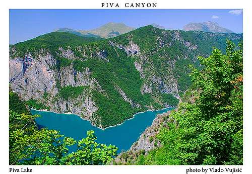
In the period of 1967-1975 large 220m high dam was build 10km upstream from Šćepan Polje and stunning 180m deep Pivsko Jezero lake was born, but sadly river killed and lot of canyon submerged. Lake extends even into part of Komarnica Canyon. Important Pivski Manastir monastery was moved from Piva source to higher location and new Pluzine were built. Pivski Manastir monastery dates from 1573 and has 1260 square meters of very valuable frescoes, which were drawn in 1604 and 1605. It is dedicated to ‘Ascent of mother of God’.

Part of the road towards Šćepan Polje border between Montenegro and Republik of Srpska (Bosnia and Herzegovina) going through the canyon of Piva, along the Pivsko Jezero lake. After that, behind the dam, the road continue through the rest of the canyon, how it originally looked before the dam building. That natural part of the canyon is most spectacular part of the Piva Canyon, where crystal clear green and blue Piva runs deep below fantastic road while cliffs tower wildly above.
 Piva Lake |
 Piva Canyon |
 Piva Lake |
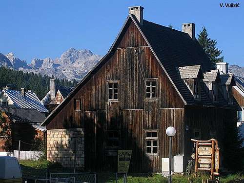
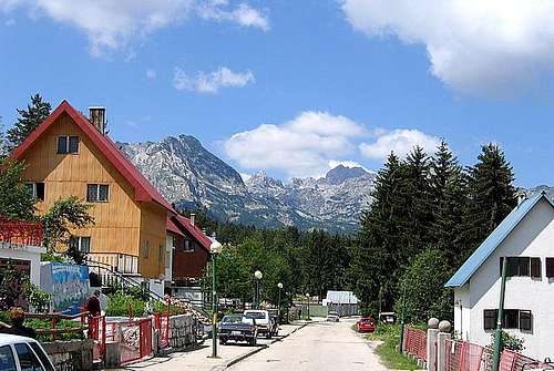
Zabljak town
 Winter in Zabljak (1456 m)
Zabljak town is situated in the north-west of Montenegro, in the heart of the Durmitor National Park, 1456 meters above sea level, making it thus the highest urban conglomerate in the Balkans and also in whole Europe.
Right in the middle of the Durmitor region, Zabljak is surrounded by 23 mountain peaks over 2200 m high, with 18 mountain lakes, and with the canyon of Tara river, the deepest in Europe. In Zabljak and in nearby villages some 4500 inhabitants live.
The first Slav name of the place was “Varezina voda” possibly because of the strong source of drinkable water nearby, making urbanity possible. Later, the urbanity was renamed “Hanovi” or originally “Anovi” because there caravan took a rest. The today’s name is from the year 1870, when in one and the same day the building of a school, of a church and of a captain’s home was begun. In the days of War and war rages all of the old buildings were destroyed. Left was only the old church of Sveto Preobrazenje (Holy Transfiguration), built in 1862 as a monument to the victory in the battle against Turks.
Right after Zabljak was established as a town, a few retail stores and a few cafes were opened, also. Thus, in the nineteen eighties Zabljak already was some kind of a market-place making it in time also the regional administrative center. In the period shortly before WW II, Zabljak was a small town with the typical mountain architecture. Right in this times the unique nature starts to draw attention of tourists from the Kingdom of Yugoslavia, but also from abroad. Very often numerous guests from Italy – because of very close ties between Montenegro and Italy – came.
 Alpine scenery of Zabljak (1456 m) town
Beside the fantastic beauty of this region the richness of this region in animal life, and also all the favors of hunting and fishing beacons to lovers of such life. During WW II the small town was burnt right to its foundations. Everything was left to flames, the homes, the monuments, the buildings. Left were only the smoky sites of fires.
When the war ended, Zabljak rebuilt itself and became the Center of winter sports in Montenegro. The unique and varied nature in such a small region recommended Zabljak as the ecological capital of the first ecological state on this planet. The deputies of the Folk Assembly of Montenegro, intoxicated with the fresh mountain air, in an out-of-order Assembly, right here, under the blue skies brought forth the Declaration unisonous, making Montenegro the first ecological state on this planet, and made Zabljak its capital.
Today, Zabljak is tourist oriented, but also oriented towards the production of all ecological. It certainly will succeed, and Zabljak is going to take it’s place in the ecological society that is coming. The new way of thinking, private initiative, the coming of foreign capital and openness to all that is new and good will make Zabljak a very highly developed tourist destination, of European renown. The season stretches over all year: Winter tourism, Spring tourism and Fall (seminars, rafting, hunting and fishing...), but Summer, yes, Summer (rest, recreation, sports...).
The people from this regions, according to Jovan Cvijic, are of the Dinaric race. He writes: "The people of Durmitor are strong, very high, slender, never fat, with intelligent faces, strong cheekbones, eagle eyes, possible the most beautiful people on the Balkans".
Difficult times, difficult climate, pushed the people from this regions, always in some war, but always grabbing from parsimonious nature whatever could be grabbed, trying to make nature an ally, but not always successfully. This war incessant allowed only the fittest (strongest) to survive, with the migration being a constant plague. This war without boundaries led to what a poet said: from stone only something harder may be brought forth, and stone is a human cradle, and the mountain a noble street. That’s the way Durmitor people are, highlanders, stronger than stone – even if this stone was the strongest deterrent against invaders – always ready to defend stones and themselves as something most valued on the face of this earth.
 Durmitor peaks above Zabljak (1456 m)
In Zabljak town you will have chance to taste some Montenegrin food specialities ('kajmak', 'cicvara', 'jagnjetina ispod saca', 'ovcije kiselo mlijeko', 'krompir ispod saca',...).
Infrastructure: Bus Station, few hotels, Post, Supermarket, Internet cafe, few restaurants, few shops, bakery, few tourist agencies, ski and bike renting services,...
When you will visit Zabljak town and Durmitor National Park, you will for sure feel the real peace, the amalgamated tradition with the modern life, a touch of antouchable and amazing nature and all of those God's gifts which God and Mother Nature gives to Durmitor mountain.
 |  |  |  |  |
Getting there
 Alpine landscape of Durmitor
Gateway to Durmitor is Zabljak town. Information how to get there:
By Plane
~To Beograd (Belgrade, Serbia&Montenegro capital) airport. Than with plane to Podgorica, capital of Montenegro, or with bus or car to Zabljak town.
~To Podgorica airport. Than with bus or car to Zabljak town.
Information about flights find on the sites of JAT Airways, a former Yugoslav airlines, or on Montenegro Airlines.
By Bus
~Beograd (Belgrade)-Zabljak
~Podgorica-Zabljak
~Niksic-Zabljak
~Pljevlja-Zabljak
Buses go to Zabljak from Beograd (Belgrade) twice a day and from Podgorica, Niksic, Pljevlja and Mojkovac several times per day.
By Car
~Beograd (Belgrade)-Zlatibor-Nova Varos-Prijepolje-Pljevlja-Zabljak
~Niksic - Savnik (47km) - Zabljak (37km): 84km; Niksic to Zabljak approach from south.
~Niksic - Savnik (35km) - Zabljak (37km): 72km;
~Podgorica - Niksic (55 km)-Savnik (47 km)-Zabljak (37 km): 139 km; Add this length if you are going to Zabljak from Podgorica via Niksic. Road to Niksic from Podgorica is good.
~Podgorica - Kolasin (71km) - Mojkovac (21km) - Zabljak (67km): 159km; road is good all the way to Zabljak. Behind Podgorica (56m) you go inside Moraca River canyon (one of spectacular Montenegrin canyons). It is up to 1000m deep and has wild sides. That's spectacular drive. After that, from "Djurdjevica Tara" bridge to Zabljak - 23 km.
 |  |  |  |  |
When to climb
 |
 Going to Bobotov Kuk
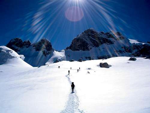
You can climb during all year seasons, but ideal period for climbing is mid June - mid September.
During the winter, Durmitor usually switches into ski resort. Under Savin Kuk peak (2313 m) is Durmitor Ski Center. (gondolas, ski lifts, chair lifts, restorants and their customers).
 On the summit of Savin Kuk (2313 m)
Crno Jezero (Black Lake) location is a common climbing starting point. All major trails further uphill are well marked with white circle/red border marks.
Whole Durmitor mountain is very good marked. Thanks to Branislav Cerovic, greatest knower and devoter of Durmitor National Park, who marked all routes on Durmitor mountain.
 |  |  |  |  |
Camping
 Shelter in Velika Kalica valley
 Skrka Hut (1723 m)
 Susica Hut
 Bivouac in Velika Kalica valley
 Lokvice shelter
Camping permitted on camping dedicated spots only. Major huts are in good condition, but with no service. Still, open to the general public. Hikers/climbers are supposed to bring all the jummy stuff with them.
HUTS
1. Hut in Skrka Lakes Valley (1723 m). Active: June 1 - October 1.
2. Hut in Susica Canyon
SHELTERS & BIVOUACS
1. Bivouac in Velika Kalica valley
2. Shelter in Lokvice Valley (1693 m)
3. Stari Katun on the road from Zabljak to Obla Glava (2303 m) peak, near Ledena Pechina (Ice Cave) - empty simply hut from wood, without service, simple conditions...
CAMPS
1. Camp "Mlinski Potok", Pitomine, 84220 Zabljak. Owner: Mina Samsal. Mobile: +382 (0)69 497 625
2. Camp "Ivan Do". Owner: Radoman Sibalic. Camp price for camping is 4 Euro per day.
Also, in Zabljak town you can rent private room or apartment. Price for 2-beds apartment with kitchen and bathroom: 10-14 Euro (5-7 Euro per person).
In some villages on mountain, for example in Bosaca village, you can rent a 2-beds apartment for price 6-8 Euro (3-4 Euro per person) with free milk products every day (1 liter of caw milk).
 |  |  |  |  |
Routes overview
 |
BOBOTOV KUK (2523 m):
Northern and southern Bobotov Kuk approaches are very nice and also different that is dificult to recommend one. Most wonderful way to climb Bobotov Kuk is to cross whole central Durmitor in a daily trip, using one route to go to the summit and the other for descend.
~ Northern approach I: Crno Jezero (1416 m) - Jaksica Mlin (1425 m) - Indjini Dolovi (1750 m) - Lokvice valley (Stari Katun, 1880 m) - Korita (1900 m) - Ledena Pecina (Ice Cave, 2160 m) - Valoviti Do (2150 m) - Velika Previja pass ( 2351 m) - Bobotov Kuk (2523 m). Time: 5.30 h to summit and 4.30 h for descend to Zabljak. One day trip (10 h).
~ Northern approach II: Crno Jezero (1416 m) - Jaksica Mlin (1425 m) - Korita - Ledena Pecina (Ice Cave) - Biljegov Do - Valoviti Do (2027 m) - Velika Previja pass (2351 m) - Bobotov Kuk (2523 m). Time: 5.30 h to summit and 4.30 h for descend to Zabljak. One day trip (10 h).
This particularily applies climbing this peak from the north side, from Zabljak. Right from the foot of the mountain you’ll pass through a primeval forest in the middle of which thrones the Crno jezero (Black lake). After climbing a steep incline on the bottom of an ancient glacier you will reach the katun (a mountain cottage cum sheep-pen) Lokvice. From here, right over the Biljeg dol and the glacier circ Valoviti do you will see from famous viewpoint called "Skrcki Pogled" (Skrka View) the giant glacier circ of Skrka, 800 m deep. From here, it will take you some twenty minutes to reach Bobotov Kuk summit.
~Southern approach I: Sedlo pass (1907 m) - Uvito Zdrijelo (2140 m) - Surutka (2082 m) - Zeleni Vir lake (Green Vortex lake, 2028 m) - Velika Previja pass (2351 m) - Bobotov Kuk (2523 m). Time: 3 h to summit and 2 h for descend to Sedlo pass.
~Southern approach II:: Sedlo pass (1907 m) - Uvito Zdrijelo (2140 m) - Trojni Prevoj (Tripple Pass, 2245 m) - Zeleni Vir lake (Green Vortex lake, 2028 m) - Velika Previja pass (2351 m) - Bobotov Kuk (2523 m). Time: 3 h to summit and 2 h for descend to Sedlo pass.
View to Bobotov Kuk from Trojni Prevoj pass (Tripple pass, 2245 m) is very beautiful and impressive. Also, from this place you can see amazing panorama of Sareni Pasovi (Stit, 2248 m), Samar saddle (2075 m) and Prutas (2393 m) peak.
During Bobotov Kuk summit climbing you can combine southern approach to reach the summit and norhern approach for descend to Zabljak town. Also, you can use norhern approach to reach summit and southern approach for descend to Sedlo pass. The best solution is to use one way to go up and another to go down.
Also, it's wonderful to use western and ridge approach to Bobotov Kuk summit, when you are deep inside of Durmitor massif.
~Western approach: Skrcka Lakes valley (1686 m) - Samar saddle (2075 m) - Zeleni Vir lake (2028 m) - Velika Previja pass (2351 m) - Bobotov Kuk (2523 m). Time: 3 h.
~Ridge approach: Bezimeni Vrh (2487 m) - Bobotov Kuk (2523 m). Time: 50 min.
BEZIMENI VRH (2487 m):
Bezimeni Vrh (No Name Peak) is second highest peak of Durmitor massif. With Bobotov Kuk (2523 m) and Djevojka (2440 m) create a famous wall known as "Soa Nebeska", above amazing beauty of Skrcka Lakes valley.
~Northern approach: Zabljak (1450 m) - Lokvice valley (1800 m) - Biljegov Do basin (1965 m) - Valoviti Do basin (2080 m) - Bezimeni Vrh (2487 m). Time: 5.15 h to summit and 4.15 h for descend to Zabljak. One day trip (9.30 h).
~ Northern approach II: Crno Jezero (1416 m) - Jaksica Mlin (1425 m) - Korita - Ledena Pecina (Ice Cave) - Biljegov Do - Valoviti Do (2027 m) - Velika Previja pass (2351 m) - Bezimeni Vrh (2487 m). Time: 5.15 h to summit and 4.15 h for descend to Zabljak. One day trip (9.30 h).
~Southern approach I : Sedlo pass (1907 m) - Uvito Zdrijelo (2140 m) - Surutka (2082 m) - Zeleni Vir lake (2028 m) - Velika Previja pass (2351 m) - Bezimeni Vrh (2487 m). Time: 3 h to summit and 2 h for descend to Sedlo pass.
~Southern approach II : Sedlo pass (1907 m) - Uvito Zdrijelo (2140 m) - Trojni Prevoj (Tripple Pass, 2245 m) - Zeleni Vir lake (Green Vortex lake, 2028 m) - Velika Previja pass (2351 m) - Bezimeni Vrh (2487 m). Time: 3 h to summit and 2 h for descend to Sedlo pass.
~Ridge approach: Bobotov Kuk (2523 m) - Bezimeni Vrh (2487 m). Time: 50 min.
To reach the summit of Bezimeni Vrh (second highest peak of Durmitor) you can combine southern approach to reach the summit and northern approach for descend to Zabljak town. Also, you can use northern approach to reach the summit and southern approach for descend to Sedlo pass. The best solution is to use one way to go up and another to go down.
The height difference is 1040 m. It is no beginner’s tour, the walking is over some very rough terrain, and it is a long one. If you walk it before August your reward will be a glacier which is there right to the end of July.
PRUTAS (2393 m):
Prutas is really something worth seeing, not only on Durmitor but afar. It is softly sloped, deep green, and adorned with oblique “Prutovi” (wands) – which, by the way, stood godfather for it’s name. If a peak can take the first place among all for a nice climb, and for enjoying a most beautyfull high-mountain sight, it for sure is Prutas. When you will come to Durmitor - don't miss a Prutas, the best viewpoint to biggest beauty of Durmitor - Soa Nebeska wall (highest peak of massif) and to amazing Skrcka Lakes valley. Also, you will see beautiful Susica canyon. If you are visiting Durmitor, don't miss Prutas (2393 m)!!!
~Southern approach: Dobri Do (Sarban water spring, 1700 m) - Skrcko Zdrijelo (2114 m) - Prutas (2393 m). Time: 2.15 h.
Prutas (2393 m) - Skrcka Lakes valley (1686 m) - 1 h.
~Western approach: Todorov Do (Pistet water spring, 1820 m) - Ilin Do pass (2230 m) - Prutas (2393 m). Time: 1.30 h.
Prutas (2393 m) - Skrcka Lakes valley (1686 m) - 1 h.
~Northern approach: Skrcka Lakes valley (1686 m) - Prutas (2393 m). Time: 2 h.
From Zabljak town (1450 m) to Virak village (1480 m), Sedlo pass (1907 m), Dobri Do (Sarban water spring, 1700 m) and Todorov Do (Pistet water spring, 1820 m) - by car or taxi. Taxi price: from Zabljak to Sedlo pass -20 Euro; from Zabljak town to Dobri Do and Todorov Do - 20-30 Euro.
The road from Stozina (below Stozina peak, 1908 m) to Sedlo pass, Dobri Do and Todorov Do - macadam road.
MEDJED (2287 m):
Medjed (Bear) is one of most popular and visited peak of Durmitor. Medjed standing proudly above amazing beauty of Crno Jezero (Black Lake) and this famous scenery is trademark of Durmitor National Park and Montenegro.
When you carefully look from Crno Jezero (Black Lake) to Medjed crest you can see two bears in the rocks, small bear on left and big bear on right side. That's the reason why that peak have a name - "Bear".
For mountaineers with no great experience in climbing middle high mountains this tour can be dangereous, especially without appropriate shoes. On some parts of Medjed ridge use of hands is necessary, because on Medjed ridge some places are exposed.
Whole ridge of Medjed is marked, between Velika Previja pass on the south to Mali Medjed on the north. Ridge is accessible by 5 marked paths, two from Struga, one from Indjini Dolovi basin, one from Lokvice valley and one from Velika Kalica valley. Also, exist circle route around Medjed massif.
~Indjini Dolovi approach: Crno Jezero (Black Lake, 1416 m) - Indjini Dolovi (1750 m) - Kljestina - Mali Medjed (2223 m) - Veliki Medjed ridge (Severni Vrh/North Peak 2287 m - Juzni Vrh/South Peak 2285 m) - Velika Previja (2145 m) - Virak (2020 m). Time: 4 h.
~Struga approach I: Crno Jezero (1416 m) - Tocak water spring - Struga (1920 m) - Mali Medjed (2223 m) - Veliki Medjed ridge (Severni Vrh/North Peak 2287 m - Juzni Vrh/South Peak 2285 m). Time: 3.15 h.
~Struga approach II: Crno Jezero (1416 m) - Tocak water spring - Struga (1920 m) - Medjed ridge (2160 m) - Veliki Medjed (Severni Vrh/Norht Peak 2287 m - Juzni Vrh/South Peak 2285 m). Time: 3 h.
~Velika Kalica approach: Crno Jezero (1416 m) - Tocak water spring - Struga (1920 m) - Velika Kalica valley (1870 m) - Velika Previja pass (2145 m) - Juzi Vrh Medjeda (South Peak, 2283) - Veliki Medjed (Severni Vrh/North Peak, 2287 m). Time: 3.15 h
~Lokvice approach: Crno Jezero (1416 m) - Indjini Dolovi (1750 m) - Lokvice valley (1693 m) - Bavani - Velika Previja pass (2145 m) - Juzni Vrh Medjeda (South Peak, 2283) - Veliki Medjed (Severni Vrh/Norht Peak, 2287 m). Time: 3 h
~Circle route around Medjed massif: Crno Jezero (1416 m) - Lokvice valley (1693 m) - Velika Previja pass (2145 m) - Velika Kalica valley (1870 m) - Struga pass (1920 m) - Crno Jezero (1416 m). Or in another direction. Time: 5 h
MININ BOGAZ (2387 m):
It is the most needle-like of all Durmitor’s peaks. It’s peak is like an alpine needle.
~Route: Zabljak (1540 m) - Katun Lokvice (1800 m) - Biljegov Do (1965 m) - Sagorjele Ploce (2120 m) - Minin Bogaz (2387 m). Time: 4.15 h. It's no easy tour - the walking is over some rough space, and it takes time.
SLJEME (2455 m):
~ Crno Jezero Lake (1416 m) – Mioc Poljana (1569 m) – Panalj (1813 m) – Cista Strana – Sljeme (2455 m). Time: 4h
~ Savin Kuk (2313 m) – Zdrijelo couloir – Sljeme (Istocni Vrh, East Summit, 2445 m). Time: 45 min
SAVIN KUK (2313 m):
~ Crno Jezero (1416 m) - Tocak water spring - Mioc Poljana (1569 m) - Derneci - Savina Voda water spring (Sava's Water, 2212 m) - Savin Kuk (2313 m). Time: 3 h
~ Sljeme (Istocni Vrh, East Summit, 2445 m) - Zdrijelo couloir - Savin Kuk (2313 m). Time: 45 min
TERZIN BOGAZ (2303 m):
Marks reached Terzin Bogaz from Velika Previja pass. This pass can be reached both from Lokvice and Velika Kalica valleys. It's summit is wonderful viewpoint. Difficulty of Terzin Bogaz climbing: VI+
~Route I: Crno Jezero (1416 m) - Struga pass (1920 m) - Velika Kalica valley - Bivak refuge (2020 m) - Velika Previja pass (2145 m). Time: 2.45 h
~Route II: Crno Jezero (1416 m) - Indjini Dolovi - Katun Lokvice (1700 m) - Velika Previja pass (2145 m). Time: 2.50 h
~Route III: Velika Kalica valley - Velika Previja pass (2145 m) - Terzin Bogaz (2303 m). Time: 1h
DJEVOJKA (SOA, 2440 m):
~Southern (Sedlo pass - 1907 m) approach I: Sedlo pass (1907 m) - Uvito Zdrijelo (2140 m) - Surutka (2082 m) - Zeleni Vir lake (Green Vortex lake, 2028 m) - Velika Previja pass (2351 m) - Djevojka (2440 m). Time: 2.45 h to summit and 1.45 h for descend to Sedlo pass.
~Southern (Sedlo pass - 1907 m) approach II:: Sedlo pass (1907 m) - Uvito Zdrijelo (2140 m) - Trojni Prevoj (Tripple Pass, 2245 m) - Zeleni Vir lake (Green Vortex lake, 2028 m) - Velika Previja pass (2351 m) - Djevojka (2440 m). Time: 2.45 h to summit and 1.45 h for descend to Sedlo pass.
~Northern approach I:Zabljak (1450 m) - Jaksica Mlin (1425 m) - Indjini Dolovi (1750 m) - Lokvice valley (Stari Katun, 1880 m) - Korita (1900 m) - Ledena Pecina (Ice Cave, 2160 m) - Valoviti Do (2150 m) - Velika Previja pass ( 2351 m) - Djevojka/Soa (2440 m). Time: 5 h to summit and 4 h for descend to Zabljak. One day trip (9 h).
~ Northern approach II: Crno Jezero (1416 m) - Jaksica Mlin (1425 m) - Korita - Ledena Pecina (Ice Cave) - Biljegov Do - Valoviti Do (2027 m) - Velika Previja pass (2351 m) - Djevojka/Soa (2440 m). Time: 5 h to summit and 4h for descend to Zabljak. One day trip (9 h).
BANDIJERNA (2409 m):
~Southern (Sedlo pass - 1907 m) approach:: Sedlo Pass (1907 m) - Uvito Zdrijelo (2140 m) - Trojni Prevoj (Tripple Pass, 2245 m) - Bandijerna (2409 m). Time: 2 h.
Skrka Valley approach: Skrka Mountain Hut (1723 m) - Samar Pass (2075 m) - Zeleni Vir Lake (Green Vortex Lake, 2028 m) - Trojni Prevoj (Tripple Pass, 2245 m) - Bandijerna (2409 m).
PLANINICA (2330 m):
~Usual route: Zabljak (1450 m) - Ivan Do (1470 m) - Jaksica Mlin - Zminje Jezero (1520 m) - Crapulj Poljana (1716 m) - Donja Alisnica valley (1940 m) - Gornja Alisnica valley (2091 m) - Medjedje Zdrijelo (2251 m) - Planinica (2330 m). Time: 4 h. Height difference: 900 m.
~Skrka - Planinica ascent route: Skrcka Lakes valley (1686 m) - Planinica (2330 m). Time: 2 h. Difficult ascent on very stepp rocky side of Planinica.
~Planinica - Skrka descent route: Planinica summit (2330) - Skcka Lakes valley (1686 m). Time: 1 h
CRVENA GREDA (2164 m):
~ Crno Jezero (1416 m) - Bosaca village - Jatare - Strmena Strana - Jablan Bara - Crvena Greda (2164 m). Time: 3 h
SKRCKA LAKES VALLEY:
~ southern approach from the Zabljak – Virak – Trsa macadam road, from the edge of Dobri Do. Time: 2.30 h
~ western approach from the Zabljak – Virak – Trsa macadam road, from Todorov Do. Time: 2.30 h
~ northern approach from the Susica canyon. Time: 2.30-3h
~ eastern approach from Zabljak via Alisnica & Planinica. Time: 5h
~ eastern approach from Zabljak via Bobotov Kuk & Zeleni Vir. Time: 7h
STIT (SARENI PASOVI, 2248 m):
~ eastern approach from Mlijecni Do (unmarked): 1h
UVITA GREDA (2199 m):
~ southern approach from Sedlo road pass (1907 m) (mostly marked): 45 min
SEDLENA GREDA (2227m):
~ northern approach from Sedlo road pass (1907 m): 1.30 h
LOKVICE VALLEY (1693 m):
~ Crno Jezero Lake (1416 m) - Indjini Dolovi - Katun Lokvice (1700 m): 1.50 h
~ Katun Lokvice (1700 m) - Ledeni Do - Trojni Prevoj (2245 m): 1.40 h
VELIKA KALICA VALLEY (1870 m):
~ Crno Jezero (Black Lake, 1416 m) - Struga pass (1920 m) – Velika Kalica valley - Bivak refuge (2020 m): 2.15 h
~ Crno Jezero - Indjini Dolovi - Katun Lokvice (1700 m) - Bavani - Velika Previja pass (2145 m) - Velika Kalica valley (1870 m): 2.30 h
 |  |  |  |  |
Weather conditions
The best weather forecast on Internet for Durmitor (Zabljak town) is VREME YUBC NET site. You can see 5 days forecast for Durmitor area, 4-times-daily forecast. |  |  |  |  |
Maps&Books
MAPS:Exist three maps of Durmitor:
1. Map of Durmitor Massif & Tara Canyon - 1:25000. Author: Branislav Cerovic. You can buy it in Zabljak town in almost every store. Price: 5-6 euro.
2. Map of Durmitor National Park & Tara Canyon - 1:25000. Author: Branislav Cerovic. You can buy it in Beograd (Belgrade, Serbia) in Geokarta Co, Belgrade. Price: 2 euro. This map is better than first one and include many informations and facts about routes, peaks, lakes, glacial cirques, valleys, canyons,...
3. Durmitor Mountain Guide & Map. Short mountain guide with some basic informations and facts. Author of map: Pavle S. Bandovic. Editor: "Summit" Travel Agency, Zabljak, 2005. Price of Guide&Map: 7 euro.
BOOKS:
2 books with maps that should be taken into consideration:
~1.BRAJOVIC, Mihailo
"Durmitor i Tara : Svjetska prirodna bastina"
Durmitor 1:50000 scale map included.
Book is written in Serbian, however the map included is written in English language too. Map can be bought separately at a reception desks of the major hotels and in touristic agency in Zabljak.
~2.CEROVIC, Branislav
" Durmitor i kanjon Tare"
Nice book, english edition available too.
Durmitor NP map included, with 1:25000 hiking map printed on the front side and 1:50000 scale tara canyon rafting map printed on the back.
 | 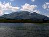 |  |  |  |
Red Tape
No fees or extra fees for entering the National Park.No permits needed either.
Usual rules of behaviour for NPs do apply.
 |  |  |  | 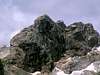 |
Miscellaneous Info
Official currency in Montenegro is Euro.Travellers cheques are not that easy to exchange (Podgoricka banka in Podgorica, Ivana Milutinovica square beiing the safest bet). ATMs are still in limited numbers, no problems finding exchange booths.
Two mobile phone operators, Pro Monte and Monet GSM, roaming enabled to and from the major countries in Europe and worldwide.
Additional Info on Durmitor may be obtained by contacting the Friends of Durmitor society:
FAETON
Drustvo ljubitelja Durmitora i rijeke Tare
tel/fax: + 382 872 61 088
tel: + 382 69 521 088
Vuka Karadzica 9a
84220 Zabljak
Montenegro
 |  |  |  |  |
External Links
- http://www.durmitorcg.com/index_eng.php
This is the official Durmitor web page.
Thankfully, in English language too...
palic - Jul 7, 2007 4:47 pm - Voted 10/10
External linkHi Vlado, here http://www.ho-vsetin.com/view.php?cisloclanku=2007040301 is our photos and trip report from skialp in Durmitor mountains in spring 2007. If you find these photos interesting and attachable to Durmitor page, please, attach them. Best regards, palic
peterbud - Aug 19, 2010 2:11 pm - Voted 10/10
fees and mapAs for 2010 summer, there was an admission fee of 2 EUR per person per day. It could be bought from NP rangers strolling on the most frequented hiking trails. Also, at Lokvice, 3 EUR per small tent per day was charged each morning. It is useful to keep some coins for these expenses, as the rangers tend not to have enough change if you're trying with banknotes. At the post office in Zabljak I got hold of an 1:22000 map by Intersistem, which is not mentioned here. It seems to be a recent product, and although some discrepancies exist (i.e. the first part of Lokvice - Trojni prevoj pass is shown as marked route, while in fact it is not), it is generally okay. Legend and short introduction is also printed in English.
dido2 - Sep 22, 2010 6:06 am - Hasn't voted
A free GARMIN GPS map of Durmitor & Pivska planinaCan be downloaded from the BGMountains site: The map installer http://bgmountains.org/en/maps/category/11-p?download=43%3A20100921 The legend: http://bgmountains.org/en/maps/category/4-?download=41%3A_
Florin Stana - Aug 10, 2013 7:55 am - Hasn't voted
Entrance feePresently (August 2013) there is a 3 EUR entrance fee to be paid to park rangers.