


-
 2025 Hits
-
 81.84% Score
-
 14 Votes
|
|
Area/Range |
|---|---|
|
|
45.73820°N / 6.88345°E |
|
|
Hiking, Mountaineering, Scrambling |
|
|
Summer, Fall |
|
|
10669 ft / 3252 m |
|
|
Note
La montagna chiama i suoi figli, ed essi rispondono fedelmente al suo appello… Osvaldo Cardellina, Diario alpinistico, 1964-65 Page texts: @ OsvaldoCardellina "Osva", passed away on May 2, 2022. Page owners: Christian Cardellina e Osvaldo Cardellina. Any updates from September 12, 2022: Antonio Giani, page administrator, friend and climbing companion. Testi della pagina: @ OsvaldoCardellina "Osva", scomparso il 2 maggio 2022. Proprietari pagina: Christian Cardellina e Osvaldo Cardellina. Eventuali aggiornamenti dal 12 settembre 2022: Antonio Giani, amministratore della pagina, amico e compagno di salite. |
Overview
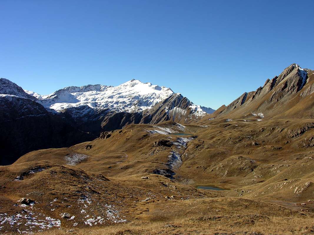
This valley opens immediately after La Thuile Municipality and, sinuously climbing towards the Northwest, forms a large S towards the Col des Chavannes (2.603m), located in turn at the confluence with the Vallone de la Lex Blanche at the foot of the beginning of the Chain of Mont Blanc (towards the Col de la Seigne). Further on, the valley opens up in a semi circular way towards the Southwest going to die against the two adjacent pyramids of Mont Léchaud (2.805 m) and Punta Léchaud (3.127m), which dominate the Glacier des Chavannes and the homonymous small lakes which, mainly three in number, lie down in the bumps formed by the basic moraines. Beyond, the dividing line falls towards East-southeast first and then East-Northeast reaching the rounded Basse Serra (2.836m) and the subsequent Col des Echelles des Chavannes or Col de Bassa Serra (2.737 meters; military fortifications of the Second World War) to finally rise again at the Pointe du Fornet (3.070m). From this point, the watershed between the Vallone des Chavannes (to the East) and that of Breuil (to the West), which had already started to exist as a divider from Pointe de Léchaud, descends decisively in the direction of the State Road n° 26 del Piccolo San Bernardo, which, reaching the Col of the same name, leads to the Parc National de la Vanoise ie in France. This rugged watershed forms Monte Ouille (3.098m), Monte Ciavaretta also with the diminutive of Chavannettes (2.849 meters, a little lower and moved to the East) and Mont Laityre (2.727m) by road and then runs out at above the plateaus called Les Côtes and the Alpine Pastures of Plan Veyles (2.080m), Chanté (1.993m), Chaz Pontailles (1.838m) and Arpettes ( 1.760m), thus returning right to the entrance of the Vallon des Chavannes itself. Eastern watershed extends itself to the wild Côte de Longeron (2.701, 2.769, 2.768, 2.729 meters) and ends with Monte Comba Varin (2.620 m) at the almost commune entrance to the two adjacent Valleys of Chavannes (to the West) Orgères. From every part of this valley, from every points as well as from every hill, there is a magnificent and incomparable panorama over the whole Mont Blanc Chain starting from Col de la Seigne in the Southwest and up to the Eastern node of the Grandes Jorasses, where the same it is directed more to the North. Then the view sweeps over Aiguilles des Glaciers, Trélatête, Lex Blanche, on the Southern Slope of Mont Blanc with the Pillars of Brouillard and the Pylons of Frêney, Aiguille Blanche and Noire and from Dente del Gigante to Jorasses passing over Arête de Rochefort, Mont Mallet. But in addition to the aesthetic factor or for lovers of photography, this valley offers a paradise of choices for lovers of Hiking and more, since even for Ski-Mountaineering the possibilities are varied, even if still little exploited. except for Punta Léchaud which has been in fashion for a while. Always taking into account the safety to be kept as main and primary value, because these parallel valleys (Orgères, Chavannes, Breuil-Tormotta) are all dangerously exposed to snowslides and avalanches ...
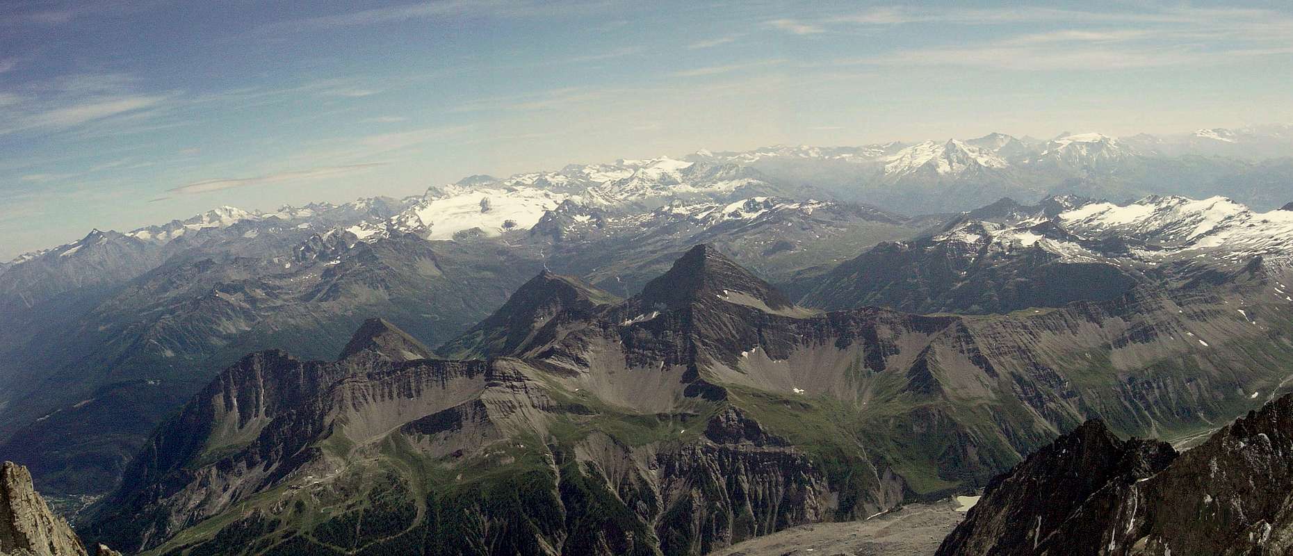
Questo vallone si apre subito dopo il Comune La Thuile e, risalendo sinuosamente verso Nordovest, forma una grande S in direzione del Col des Chavannes (2.603 m), collocato a sua volta alla confluenza con il Vallone de la Lex Blanche ai piedi dell'inizio della Catena del Monte Bianco (in direzione del Col de la Seigne). Più in là la valle si apre in modo semicircolare verso Sudovest andando a morire contro le due piramidi adiacenti del Mont Léchaud (2.805 m) e della Punta Léchaud (3.127 m), dominanti il Glacier des Chavannes e gli omonimi laghetti che, principalmente in numero di tre, si adagiano nei dossi formati dalle morene di base. Oltre, il divisorio rientra verso Est-sudest dapprima e poi Est-nordest raggiungendo il "panettone" arrotondato della Basse Serra (2.836 m) ed il successivo Col des Echelles des Chavannes oppure Col de Bassa Serra (2.737 metri; fortificazioni militari della Seconda Guerra Mondiale) per infine rialzarsi alla Pointe du Fornet (3.070 m). Da questo punto lo spartiacque tra il Vallone des Chavannes (ad Est) e quello del Breuil (ad Ovest), che aveva preso ad esistere come divisorio già dalla Pointe de Léchaud, scende decisamente in direzione della Strada Statale n° 26 del Piccolo San Bernardo, che, raggiungendo l'omonimo Colle, conduce al Parc National de la Vanoise cioé in Francia. Questo robusto spartiacque forma per strada il Monte Ouille (3.098 m), il Monte Ciavaretta oppure col diminutivo di Chavannettes (2.849 metri, un pò più in basso e spostato ad Oriente) ed il Mont Laityre (2.727 m) per poi esaurirsi al di sopra dei pianori chiamati Les Côtes e gli Alpeggi di Plan Veyles (2.080 m), Chanté (1.993m), Chaz Pontailles (1.838m) ed Arpettes (1.760 m), così tornando giusto all'imbocco del Vallon des Chavannes medesimo. Lo spartiacque Orientale invece, si allunga alla selvaggia Côte de Longeron (2.701 m, 2.769 m, 2.768 m, 2.729 metri) per indi terminare con il Monte Comba Varin (2.620 m) all'entrata quasi comune dei due Valloni adiacenti di Chavannes e di Orgères, ad Oriente. Da ogni parte di questo vallone, da ogni Sommità come da ogni colle, si dispendia un panorama magnifico ed ineguagliabile su tutta la Catena del Monte Bianco a partire dal Col de la Seigne a Sudovest e fino al nodo Orientale delle Grandes Jorasses, dove la medesima si indirizza più a Settentrione. La vista spazia sopra Aiguilles des Glaciers, Trélatête, Lex Blanche, sul Versante Meridionale del Monte Bianco con i Pilastri del Brouillard ed i Piloni del Frêney, Aiguille Blanche e Noire e dal Dente del Gigante alle Jorasses passando sopra l'Arête de Rochefort, Mont Mallet. Ma oltre che per il fattore estetico oppure per gli amatori della fotografia, questo vallone offre un paradiso di scelte per gli amanti dell'Escursionismo e non solo, poiché anche per lo Sci-Alpinismo le possibilità risultano variegate,anche se a tutt'oggi poco sfruttate tranne che per la Punta Léchaud di moda un pò da sempre. Sempre ternendo conto della sicurezza da tenere come valore principale e primario, perché questi valloni paralleli (Orgères, Chavannes, Breuil-Tormotta) son tutti pericolosamente esposti a slavine e valanghe ...
Getting There
BY CAR:
- From Switzerland: through the Grand Saint Bernard Tunnel or the namesake Pass towards Aosta City and from this in West to Sarre, Villeneuve, La Salle, Morgex, Pré Saint Didier, La Thuile Municipalities.
- From France, through the Mont Blanc Tunnel or Petit Saint Bernard Pass: It is not necessary to take Motorway A5: you can drive on SS.26, in the direction of Aosta, passing through La Thuile Municipality.
Specific Roads from Italy (Aosta's Valley)
- From Torino, Milano, etc: Motorway A5. Exit at Morgex (921m), continue for about 3 km on SS.26 towards Pré Saint Didier (1.017m). SS.26 becomes the main street of the small city and then continues toward Colle del Piccolo San Bernardo (2.188m). After several hairpins, and past the Villages of Elevaz (1.302m) and la Balme (1.309m) reach the famous ski resort of La Thuile (1.441m). Turn left on the bridge that crosses "Dora di La Thuile", a go on along the same road till the bridge before the small Village of Pont Serrand (+ Chapel near the Verney Torrent and below a ravine; 1.602m), turn to the right following for Orgère (1.740m), where you must leave the car.
BY PLANE:
- Aeroporto "Corrado Gex" Saint Christophe (Aosta).
All Approaches & Routes
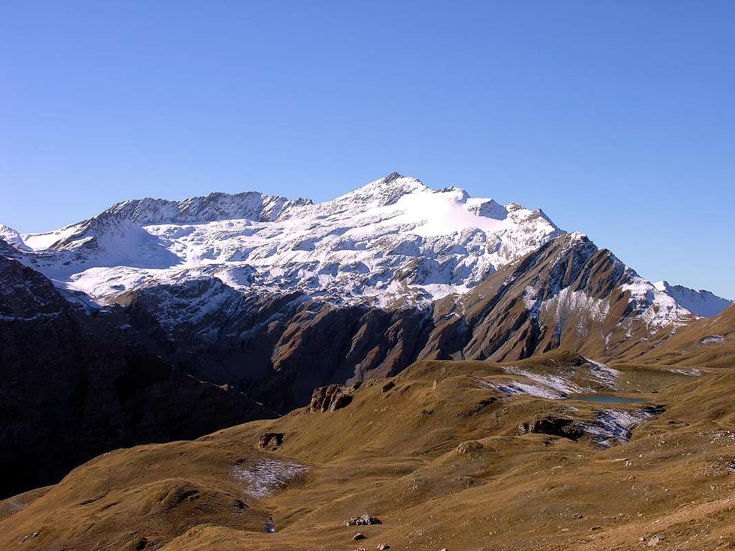
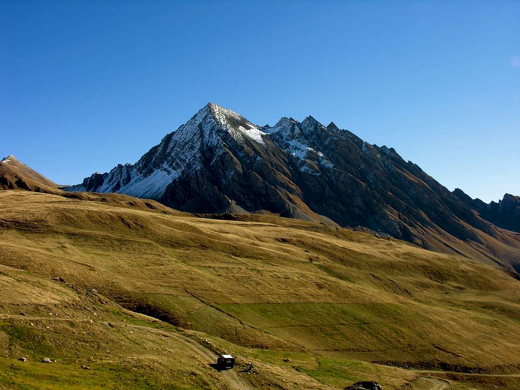
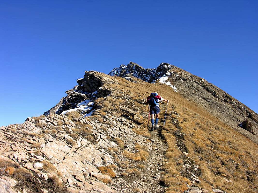
From the fork on SS.26 to continue up along the dirt farms road along the Chavannes long Valley, after passing the mountain Pastures Chavannes di Sotto (2.128m), Chavannes di Mezzo (2.183m) and Chavannes di Sopra (2.421m); go straight before towards Northeast after North-northwest to get the Col du Baracon (2.421m) or towards West-northwest up to the extreme Col des Chavannes (2.603m). From the first of these points, if you want to continue, walk herefrom go along the wide ridge crossing the Mont Fortin (2.758m) and the Punte di Chavannes (2.811m). Following the ridge the path goes slightly down to the quota 2.728 meters. On, zigzagging along the Western Ridge then cross to the right along the Southern Slope to get the Colle di Berio Blanc (2.824m). On along the steep grassy and debris slope to get the higher or Western Top (2.967m), and following the ridge get the Central Summit (2.962m) and the Northern Summit (2.958m), that presents some exposed and tricky passages on bad quality rock. But these are not the main peaks that dominate over this almost a valley, but two summits placed exactly opposite stand out above everything. In fact, Mont Berio Blanc rises to the East, the ascent of which from this side is not the simplest, although not very difficult but rather complicated in the search for the route; while downhill it is worthwhile, even if it involves a significant logistical complication, to descend on the opposite or Eastern Slope through an high gully of about 780/800 meters in the Vallone di Orgère and then reconnect to the previous itinerary near the prohibition sign on the dirt farms road located between the Plan Bovard and Monquet Alps just at above that of Arpettes. From this point, as already described above, continue on foot along the dirt road into the Chavannes Valley and, after passing Chavannes Pastures (2.128m), towards North up to the Berio Blanc (name in dialect of Aosta Valley with signification of "White Stone") di Sopra Pastures (2.439m), just at the base of the Southwestern side of the mountain. Cross in plan towards East to get the wide canyon coming down left of the big spur ending on the Central Summit. On along it on debris and big slabs, often dirty with mould, till a little under the Central Summit . From the high part of the rocky channel cross to the left to get a small couloir that goes on to a notch on the Southern Ridge. Follow the watershed crest on slabs and unstable but safe rocks. This itinerary must be considered at the limit between Hiking and Mountaineering and, if in the presence of hard snow tongues, one must lean towards this second evaluation: in any case it is a path aimed at very experienced hikers and adequately equipped with rope, ice ax, crampons. and, why not, wanting to increase safety, a lot of helmet. On the opposite side of the valley or Southwest, as well as between the valleys and the glaciers of the Glacier des Chavannes and the Glacier du Breuil, the pyramid rises a little less high, surrounded by the same ones of the Pointe Léchaud, anticipated to the North by Mont Léchaud and preceding the Petit Léchaud in the South and the Bassa Serra in the East. Similar considerations apply to this climb as well, because the opposite side or the Breuil / Tormotta side allows an easier climb and a similar return to the vehicles reaching the Piccolo or Little Saint Bernard National Road or SS.26 at the hairpin bend at an altitude of 1.866 meters at Alpe Crétaz (1.866m) , at the foot of Tete de Tsargian (+; 2.078m). On the Chavannes side, on the other hand, attention must be paid to a small traverse above a snowy gully, sometimes frozen, marked in yellow signs with a path that crosses the Eastern Slopes of Mont Léchaud and then heads towards the South on a track that leads to Lacs du Glacier des Chavannes (2.713m), which you leave on the left (East) to enter the glacier of the same name. Here too the same considerations apply as for Mont Berio Blanc: a traverse at mid-altitude, suspended between some crevasses, can create some problems if it is found in hard ice also "verglass", while the last part on fine debris and little rocks is a path elementary. A third Summit or Mont Percé (+; 2.844m), having the characteristics of median difficulty between these last two peaks and the previous ones, is located exactly halfway on the watershed between the Vallone des Chavannes and that of the Lex Blanche and, for greater precision, between the Col des Chavannes and Mont Fortin. This peak is really scarcely frequented because its ascent both from Colle Baracon and from that of Col des Chavannes is complicated and unsafe due to grassy clods on the rock formed by inclined and fragile rocky banks; the nearby Mont Fortin is preferred, from which you can enjoy the same view, but, above all, thanks to a much easier and safer route. Besides other elevations, certainly less known and above all less frequented, complete the picture of the district. On the Eastern watershed, after the characteristic South Crest formed by a series of elevations shaped a jags, the Côte de Longeron extends (2.701, 2.769, 2.768, 2.729 meters) of Mont Berio Blanc and ends with Monte Comba Varin (2.620 m) just above above Plan Mottey and Plan Berard at the entrance to the two adjacent valleys of Chavannes (to the West) and Orgères (in East). On the opposite or Western dividing line, as well as between Vallone des Chavannes and the dual one of Breuil / Tormotta, after the Bassa Serra and Mont Fornet, the watershed crest descends in an arc forming Mount Ouille (3.098m) and Punta di Laityre (2.727m), with the first is scarcely frequented while the last has a good participation thanks to a well signposted path n° 10 A with double departure from both Arpettes and Plan Veyles. Surely these Summits between Vallons des Chavannes and Breuil /Tormotta are preferably to be climbed on this last side even if we do not find any paths present; while Bassa Serra can be easily climbed both from one and the other of two sides, thanks to the path n° 10 which climbs from the Southeast to the Col des Echelles des Chavannes, reached instead from the opposite direction by an unnumbered path-track that comes, tourning slightly to the left, from Lacs du Glacier des Chavannes. Oh, we forgot: the most important path that, coinciding with the dirt farms road, goes up the entire Vallon des Chavannes is that n° 11/Alta Via n° 2 from Pont Serrand Hamlet.
Dal bivio sulla SS.26 continuare a piedi sulla strada interpoderale in terra battuta il lungo Vallone di Chavannes, dopo aver superato gli omonimi Alpeggi di Chavannes di Sotto (2.128 m), Chavannes di Mezzo (2.183 m) e Chavannes di Sopra (2.421 m); puntare decisamente dapprima verso Nordest eppoi Nord-nordovest sino a raggiungere il Col du Baracon (2.714 m) oppure ad Ovest-nordovest fino a raggiungere l'estremo Col des Chavannes (2.603m). Dal primo di questi punti, volendo proseguire, proseguire sul largo quasi arrotondato crestone e oltrepassare il Mont Fortin (2.758 m) e subito dopo le Punte di Chavannes (2.811 m); sempre su cresta il sentiero scende leggermente sino a raggiungere quota 2.729 metri. Proseguire con qualche zig zag lungo la cresta Occidentale per poi iniziare a traversare verso destra lungo il Versante Meridionale, sino a raggiungere il Colle del Berio Blanc (2.824 m); da qui salire il ripido pendio tra sfasciumi e zone d'erba sino a raggiungere la più elevata Punta Ovest (2.967 m). Da questa, tenendosi sul filo della cresta, si raggiunge la Punta Centrale (2.962 m) e di seguito la Punta Settentrionale (2.958 m), con alcuni passaggi delicati ed esposti su rocce abbastanza instabili. Ma non sono queste le cime principali che dominano sopra questo vallone, bensì due Sommità piazzate esattamente all'opposto svettano sopra ogni cosa. Ad Oriente si eleva infatti il Mont Berio Blanc , l'ascesa del quale da questo lato non é delle più semplici, anche se non molto difficile ma piuttosto complicata nella ricerca della via; mentre in discesa conviene, anche se implica una complicazione logistica non indifferente, scendere sul versante opposto, tramite un canalone di circa 780/800 metri d'altezza, od Orientale nel Vallone di Orgère per poi ricollegarsi al precedente itinerario nei pressi del cartello di divieto sulla strada poderale posizionato tra le Alpi di Plan Bovard e Monquet appena al di sopra quella di Arpettes. Da questo punto, come già sopra descritto, proseguire a piedi sulla strada in terra battuta il lungo Vallone di Chavannes, dopo aver superato l'Alpeggio di Chavannes di Sotto (2.128 m). Quindi proseguire a Settentrione fino a raggiungere l'Alpeggio di Berio Blanc di Sopra (2.439 m; con toponimo valdostano atto a significare "Sasso Bianco di Sopra!), alla base del versante Sudovest della montagna. Da qui attraversare verso Est quasi in terreno pianeggiante e per pascoli raggiungere il largo canalone che scende sulla sinistra del grande costone terminante sulla Punta Centrale. Risalire il detto canalone di detriti e grandi placche inclinate, sovente coperte da terriccio, sino sotto la Punta Centrale. Dalla cima del canalone traversare in diagonale sulla sinistra sino a un valloncello che continua a salire, sempre sulla sinistra (verso Settentrione), fino a un colletto sulla cresta Sud della cima. Da questo punto, sempre lungo la cresta Sud, si raggiunge la Vetta per lastroni e rocce instabili ma abbastanza sicure. Questo itinerario deve essere considerato al limite tra Escursionistico ed Alpinistico e, se in presenza di lingue di neve indurita, si deve propendere per questa seconda valutazione: in ogni caso é un percorso rivolto ad Escursionisti molto esperti ed adeguatamente attrezzati con corda, piccozza, ramponi e, perché no, volendo aumentare la sicurezza, tanto di elmetto. Dal lato opposto del vallone o Sudovest, nonché tra i valloni ed i ghiacciai del Glacier des Chavannes e del Glacier du Breuil, si eleva di un poco meno alta la piramide circondata dai medesimi della Pointe Léchaud , anticipata a Nord dal Mont Léchaud e precedente il Petit Léchaud a Meridione e la Bassa Serra ad Oriente. Anche per questa salita valgono similari considerazioni, perchè il Versante opposto oppure del Breuil/Tormotta permette una salita più agevole ed un analogo rietntro ai mezzi di trasporto raggiungendo la Strada Nazionale del Piccolo San Bernardo oppure SS.26 al tornante a gomito a quota 1.866 metri presso l'Alpe Crétaz (1.866 m), ai piedi della Tete de Tsargian (+; 2.078 m). Sul lato Chavannes invece bisogna prestare attenzione ad un piccolo traverso soprastante un canalone nevoso, a volte ghiacciato, segnalato in giallo con sentiero attraversante il lato Orientale del Mont Léchaud per poi indirizzarsi verso Meridione su di una traccia conducente ai Lacs du Glacier des Chavannes (2.713 m), che si lasciano sulla sinistra (Est) per inserirsi sull'omonimo ghiacciaio. Anche qui valgono le stesse considerazioni che per il Mont Berio Blanc: infatti un traverso a mezza quota, sospeso tra alcuni crepacci, può creare qualche problema se lo si trova in cattive condizioni con "verglass" ovvero ghiaccio duro oppure vetro, mentre l'ultima parte su detrito fine e roccette risulta di percorso elementare. Una terza Sommità o Mont Percé (+; 2.844 m), avente le caratteristiche di difficoltà mediane tra queste due ultime vette e le precedenti, é collocata, esattamente a a mezza strada sullo spartiacque tra il Vallone des Chavannes e quello de la Lex Blanche e, per maggior precisione, tra Col des Chavannes ed il Mont Fortin. Questa Vetta é veramente scarsamente frequentata perché la sua salita sia dal Colle Baracon che da quello des Chavannes risulta complicata ed insicura a causa di zolle erbose sulla roccia formata da banconate inclinate e fragili; gli si preferisce il vicino Mont Fortin dal quale si gode di identico panorama, ma, soprattutto, grazie ad un percorso nettamente più facile e sicuro. Inoltre altre elevazioni, sicuramente meno conosciute e soprattutto meno frequentate, completano il quadro del circondario. Sullo spartiacque Orientale, dopo la caratteristica Cresta Sud formata da una serie di dentellature, del Mont Berio Blanc si allunga la Côte de Longeron (2.701 m, 2.769 m, 2.768 m, 2.729 m) terminante con il Monte Comba Varin (2.620 m) giusto al di sopra di Plan Mottey e Plan Berard all'ingresso dei due Valloni adiacenti di Chavannes (ad Ovest) e di Orgères (ad Est). Sul divisorio opposto oppure Occidentale, nonché tra il Vallone des Chavannes e quello duplice del Breuil/Tormotta, dopo la Bassa Serra ed il Mont Fornet, la cresta spartiacque scende ad arco formando il Monte Ouille (3.098 m) e la Punta di Laityre (2.727 m), con il primo scarsamente frequentato, mentre l'ultimo conosce una buona partecipazione grazie ad un sentiero n° 10 A ben segnalato con duplice partenza sia dagli Alpeggi di Arpettes che Plan Veyles. Sicuramente queste Sommità tra i Valloni des Chavannes e Breuil/Tormotta son preferibilmente da salire su quest'ultimo versante anche se non troviamo sentieristica alcuna presente; mentre Bassa Serra può essere agevolmente salita sia dall'uno che dall'altro, grazie al sentiero n° 10 risalente da Sudest al Col des Echelles des Chavannes, raggiunto invece dall'opposto da un sentiero-traccia non numerato con leggera diagonale dal Lacs du Glacier des Chavannes. Ah, si dimenticava: il sentiero più importante che, coincidente con la strada sterrata, risale l'intero Vallon des Chavannes é quello n° 11/Alta Via n° 2 dal Villaggetto di Pont Serrand.
 |
 |
 |
 |
 |
Campings
Remember that free camping is forbidden (except for emergency reasons, over 2.500m, from darkness until dawn).Mountain Condition
- You can get meteo information at the official site of the Regione Valle d'Aosta:
- Valle d'Aosta Meteo
- Meteo: You can find more weather information on the website 3B Meteo:
- La Thuile
Books and Maps
BOOKS:- "Guida dei Monti d'Italia–Alpi Graie Centrali", di Alessandro Giorgetta - Club Alpino Italiano/Touring Club Italiano, 1985 (in Italian).
- "Guida delle Alpi Occidentali", di Giovanni Bobba e Luigi Vaccarone C.A.I. Sezione di Torino Volume II (parte II), 25 Maggio 1896.
- "Valdigne gli itinerari escursionistici", di Alessandro Giorgetta, Ed. Zanichelli, Giugno 1981.
- "Guida della Regione Autonoma Valle d'Aosta" di Mario Aldrovandi, Ed. S.P.E. di Carlo Fanton, Torino 31 Dicembre 1964.
 |
 |
 |
MAPS:
- Kompass "Gran Paradiso Valle d'Aosta Sentieri e Rifugi" Carta turistica 1:50.000.
- L'Escursionista "La Thuile-Piccolo San Bernardo" (carta n° 2) 1:25.000.
- A.I.A.T. La Thuile, "La Thuile Pianta dei Sentieri", 2004 (Plastico).
- Carta Comunità Montana "Valdigne e Mont Blanc Les Sentiers", 2001 1:50.000.
- L’Escursionista "Monte Bianco Courmayeur Carta dei Sentieri" (n° 1) 1:25.000.
- I.G.C. Istituto Geografico Centrale Torino "Monte Bianco-Courmayeur-Chamonix-La Thuile" (carta n° 107), 1:25.000.
Important Information
- REGIONE AUTONOMA VALLE D'AOSTA the official site.
- FONDAZIONE MONTAGNA SICURA Villa Cameron, località Villard de la Palud n° 1 Courmayeur (AO) Tel: 39 0165 897602 - Fax: 39 0165 897647.
- A.I.NE.VA. (Associazione Interregionale Neve e Valanghe).
Useful numbers
- Protezione Civile Valdostana località Aeroporto n° 7/A Saint Christophe (Ao) Tel. 0165-238222.
- Bollettino Meteo (weather info) Tel. 0165-44113.
- Unità Operativa di Soccorso Sanitario Tel. 118.