


-
 2514 Hits
-
 79.78% Score
-
 11 Votes
|
|
Area/Range |
|---|---|
|
|
45.70030°N / 7.35340°E |
|
|
Hiking, Mountaineering, Trad Climbing |
|
|
Spring, Summer, Fall, Winter |
|
|
10633 ft / 3241 m |
|
|
Note
La montagna chiama i suoi figli, ed essi rispondono fedelmente al suo appello… Osvaldo Cardellina, Diario alpinistico, 1964-65 Page texts: @ OsvaldoCardellina "Osva", passed away on May 2, 2022. Page owners: Christian Cardellina e Osvaldo Cardellina. Any updates from September 12, 2022: Antonio Giani, page administrator, friend and climbing companion. Testi della pagina: @ OsvaldoCardellina "Osva", scomparso il 2 maggio 2022. Proprietari pagina: Christian Cardellina e Osvaldo Cardellina. Eventuali aggiornamenti dal 12 settembre 2022: Antonio Giani, amministratore della pagina, amico e compagno di salite. |
Overview
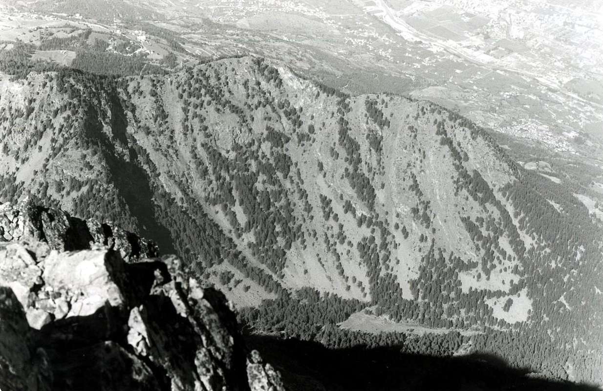
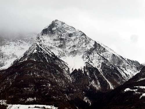
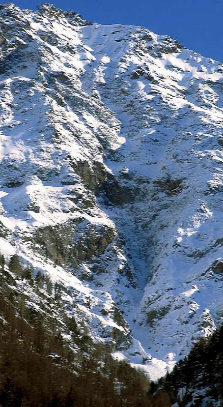
This vallon is actually a gorge underlying the Vallons of Comboé Arbolle. From the slopes of Monte Emilius (3.559m) fact falls to the South along Vallon of Arbolle that, with semi circular course, reaches in the direction opposite the Vallon of the underlying and beautiful small Valley of the Comboé (2.114m), adjacent the Pila Basin. Below this opening, as a natural continuation, descends the Vallon Dard that, like a big and very narrow funnel, tapering into a gorge ever closer and narrow to finally expand on the valley floor, between the Commons of Pollein (East) and Charvensod, before flowing with Torrent de Comboé in Dora Baltea. It is bordered to the East by the great Crest North-northeast of Becca di Nona (3.142m), degrading to the Pastures of Plan Croix (1.745m), Martsaouchy Damon (1.420/30m about), du Meitin and Dèsott and Tchino or Chenoz (1.017m), above Pollein Municipality. The watershed opposite or Western, attached with the Pila Basin now in Gressan Commune, after Colle Plan Fenêtre, gateway to the Vallon of Comboé, the ridge form three small Summit called Punta di Ponteilles (2.262/3m), Punta Valletta (2.164 m) and Punta del Dard (2.033m), this last above the Black Forest of Combatissière and the Pasture of Pouce or Pousses (1.601m). The bottom of the vallon, however, after the Comboé Dessous (2.042m), rushes through the Torrent de Comboé with a series of waterfalls that end with a largest and most spectacular on the Alp Ponteilles (1.750m), up to where it is came the great landslide of Flood of 2000 breaking away from the base of the Northern Face of "Becca". Beyond the vallon-gorge becomes a real throat reaching before the water intake of La Mare (1.187m), then the Rongachet Bridge (1.100 meters about; what he did and then plug exploding caused seven deaths), near Alpe di Reverier Dessous or Lower (1.042m; little St. Joseph Chapel). Lower down, becoming more and more a bottleneck, forms a more short waterfall at the Gym Rock S.M.A. between the Villages of Chenaux (Pollein) and Roulaz (Charvensod). The same, enough equipped from the first post-war period but probably also used in earlier times, has grown a little all Aosta Climbers. Currently has been partially demolished in order to obtain the material to build new levees to Comboé Torrent between the Hamlets Chenaux Pian Felina (Charvensod). Does not have great chances to go up as the routes from this side towards Becca di Nona are or challenging (Crestone North-northeast) or dangerous (North Wall), but it may be a variant of departure to go to the same or simply to Comboé Alp. For the three Summit minors, placed on the watershed with the Conca di Pila, you can reach, going after Comboé Alpage towards the Plan Fenêtre Hill, in crossing from South to North; is cheaper to make this route from this location starting precisely from Pila-Resort.
Questo vallone in realtà é una gorgia sottostante il Vallone di Comboé.
Dalle pendici del Monte Emilius (3.559 m) scende infatti verso Sud il lungo Vallone d'Arbolle che, con percorso semi circolare, raggiunge in direzione opposta il Vallone del sottostante Comboé, adiacente al Bacino di Pila. Al di sotto di questo s'apre, come naturale continuazione, il Vallone del Dard che, a guisa di grande e strettissimo imbuto, si restringe progressivamente in una gola sempre più angusta per infine allargarsi sul fondovalle, tra i Comuni di Pollein (Est) e Charvensod, prima di sfociare con il Torrent de Comboé nel corso della Dora Baltea. Viene delimitato ad Oriente dalla grande Cresta Nord-nordest della Becca di Nona (3.142 m), vertiginosamente digradante verso gli Alpeggi di Plan Croix, Martsaouchy Damon, du Meitin e Dèsott e Tchino o Chénoz, quest'ultimo appena al di sopra dell'abitato di Pollein. Sullo spartiacque opposto od Occidentale, divisorio con la Conca di Pila ormai nel Comune di Gressan, dopo il Colle Plan Fenêtre, porta d'ingresso al Vallone di Comboé, la cresta forma tre piccole Sommità dette Punta di Ponteilles (2.262/3 m), Punta Valletta (2.164 m) e Punta del Dard (2.033 m), quest'ultima al di sopra della Foresta Nera di Combatissière e dell'Alpeggio di Pouce oppure Pousses (1.601 m). Il fondo del vallone invece, dopo il Comboé Dessous (2.042 m), precipita tramite il Torrent de Comboè con una serie di cascate che si concludono con una più grande e spettacolare sopra l'Alpe di Ponteilles (1.750 m), fino a dove é giunta la grande frana dell'Alluvione del 2000 staccandosi dalla base della Parete Nord della "Becca". Oltre, diventa una vera e propria gola raggiungendo dapprima la presa dell'acqua di La Mare (1.187m), poi il Ponte di Rongachet (1.100 metri circa; quello che fece da tappo e poi eslodendo provocò sette morti), nelle vicinanze dell'Alpe di Reverier Dessous (1.042 m; Cappella di San Giuseppe). Più in basso, diventando sempre più strettoia, forma una cascatina presso la Palestra di Roccia tra le Frazioni di Chenaux (Pollein) e Roulaz (Charvensod). Attrezzata già dal primo dopoguerra e probabilmente utilizzata anche in tempi remoti, ha visto crescere un pò quasi tutti gli Alpinisti ed Arrampicatori Aostani. Attualmente tramite diverse opere di contenimento é stata parzialmente demolita, onde ricavarne il materiale per costruire nuovi argini al Torrent de Comboé tra le Frazioni di Chenaux e Pian Felina (Charvensod). Non presenta grandi possibilità di salite poichè le vie da questo versante alla "Becca" sono o impegnative (Crestone Nord-nordest) oppur pericolose (Parete Nord), ma può costituire una variante di partenza per recarsi alla stessa o più semplicemente al Comboé. Per le tre Sommità minori, poste sullo spartiacque con la Conca di Pila, si possono raggiungere, salendo dopo il Comboé al Colle Plan Fenêtre, in traversata da Sud a Nord; é più conveniente effettuarla da questa località partendo appunto da Pila.
Morion a secondary gorge compared to the Dard ...
 |
 |
 |
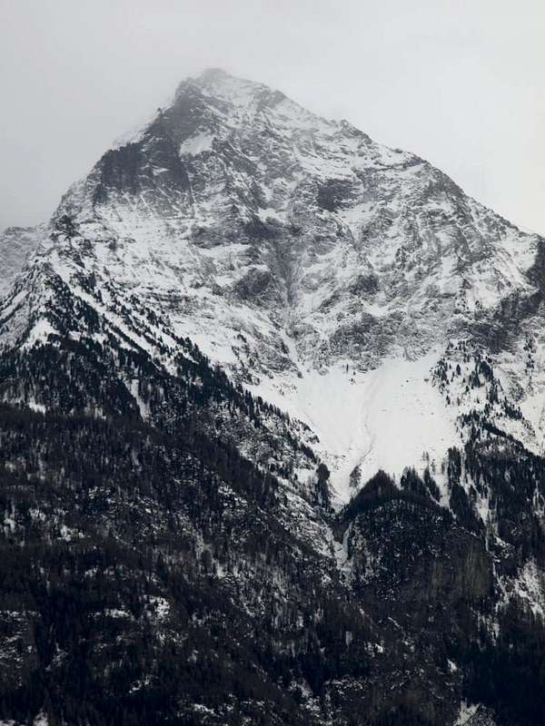
Un'altra selvaggia gorgia si innesta in quella del Dard. Da sotto la Parete Nord della "Becca" ed in direzione obliqua ripetto a La Dent (2.736 m) scende, sottostantemente al promontorio roccioso del Morion, una omonima gola, conosciuta semplicemente come "il Morion". Una scoscesa discesa che si innesta al Vallone del Dard raggiungendo il Torrent de Comboé appena al di sotto della Cascata e dell'Alpe di Ponteilles (1.697/1.706 m) e della soprastante di Pouce o Les Pousses (1.601 m), giusto alle pendici della Pointe du Dard (2.033 m). Una gola molto selvaggia e quasi del tutto non frequentata, che diventa importante alla base per la raccolta delle acque, poi indirizzate a La Mare (1.187 m) nel Comune di Charvensod, oppure per raggiungere due belle cascate di ghiaccio di moda negli Anni Ottanta. Inoltre tristemente famosa poiché sembra (non ne siam completamente convinti) che dal Morion sia arrivata la frana che, nell'Alluvione del 2000, abbia fatto esplodere il sottostante Ponte di Rongachet (1.100 m), sopra i Villaggetti di Saint Bénin, Chenaux e Chenierès dopo aver saltato la cascata attraversando il canyon ove é sita la Palestra di Roccia S.M.A. di Pollein. Evento luttuoso che l'ha cancellata ...
Getting There
BY CAR:
- From TORINO, MILANO, etc: Motorway A5. Exit at IVREA or Quincinetto (PIEDMONT) From IVREA Town: in West towards Pont Saint Martin, Donnas, Bard, Châtillon, Pontey, Fénis, Saint Marcel, Grand Brissogne, Pollein, Charvensod, Municipalities. From Courmayeur Resort: in East to Pré St. Didier, Morgex, La Salle, Arvier, Saint Pierre, Aymavilles, Sarre, Aosta, Charvensod and Pollein Municipalities.
- From Charvensod to Dard Morion Gorges through Ponteilles (1.697m) Alp and Waterfall, with dirt road or paths to Comboé Alp and Saint Ours Shelter (2.114m).
- From FRANCE: through the Mont Blanc Tunnel to Entrèves-crossroads to Vény/Ferret Valleys - Courmayeur. By Little Saint Bernard Pass, closed since November until half May to La Thuile Valley - Pré Saint Didier - Courmayeur. It is not necessary to take Motorway A5: you can drive on SS.26, in the direction of AOSTA - IVREA - TURIN.
BY PLANE:
- Aeroporto "Corrado Gex" Saint Christophe (Aosta).
Like going in Gorgia Dard?
Approaches for the starts I mediate tall and forced passage through Pousses Alp, also by Rongachet Bridge and the water intake of La Mare resort for departures middle low, always passing along the Dard Vallon, Alp and Ponteilles Waterfall at the entrance into upper Dard Gorge, near the fork 1975m around.1) Departures from the part I mediate tall of the Regional Road for Pila to altitude about 1.000 meters: a)-, b)-, c)-, d)-, e)-, f)-, g)- From and towards:
a) - the Saint Saloo also called Salò Village (1.307m) and through concomitant path with the dirt road "poderale" for Les Gorres in the first line and then with autonomous path n° 14E that, passing to South of the village and again crossed the "poderale" toward East-southeast, it goes to join around himself to altitude of 1.480 meters about with the path n° 14D, coming from few above the Fraction of Château-Charvensod (823m), passing into Bondine's Village (1.043m);
b) - Les Gorres Village (1.385m), through the preceding route; or from the alternative 1.332 meters on the Regional Road of Pila with deviation to the left (descriptive poster and of prohibition of transit with auto) reaching on dirt road "poderale" the village. Same give to continue Southeast with the path n° 14E and then to reach the alternative 1.500 meters around, as soon as before the Alp Les Leyzères (1.517m); from this to rejoin him, through brief slope of connection, to the precedent path n° 14D and to reach Les Pousses Pasture (1.601m), to the entry of the "Vallone" of the Dard or the Valley of the Waterfall.
c) - with departure from the small Village of Le Champex (1.290m; attainable after two elbow windings road on the road for Pila and with a brief line of dirt road) to go himself with the path n° 2, coming from Reverier Dessus (1.124m), toward West actually to reach the path n° 14D as soon as above the same one and with this to continue toward Les Pousses Pasture (1.601m), to the entry of the Valley of the Dard and underlying the homonym point (2.033m).
d) - Les Pousses attainable also through the dirt road "poderale" that from Les Gorres Village, with very wide turn toward Southwest it touches the Alp of Le Vaccoz (1.469m) for then to reenter toward East-northeast. *
e) - Even from Pila: or with the path n° 14L that, even beginning from Pila, it passes for the Hermitage of Saint Grat, it goes down to the Combatissière's Pastures (1.750m; splendid "rascards"), Les Usellières (1.566m), Vaccoz and from these passing under and in parallel to the road poderale) through the continuation of the dirt road or with the path n° 14L, described hardly above, to reach Les Pousses Pasture (1.601m) to the intersection with the path n° 14D, as soon as over the long stall.
f) - beginning from the Alp Les Leyzères (attainable from the path n° 14E that salt from the alternative among the two small Villages of Les Carnières (1.180m) and La Pissine Salà (1.307m); or with the long path n° 14L that, departing from Pila-Hermitage of St. Grat, it entirely crosses the Black Forest of Combattissière), through the continuation of this last toward East or on the impending and parallel dirt road, to reach shortly Les Pousses Alp.
g) - with departure from Les Pousses oppure Pouce (1.601m), at the beginning of Dard's Valley, through the path n° 14D, along a diagonal to South and near the old brook for irrigation, arriving to Comboé Torrent in altitude 1.670m around; and, after forded across on the same and crossed the dirt road, reach the Ponteilles (1.706m) Pastures. * * h) - Lower Variant: even through the below dirt road, fording twice the Comboé Torrent reach the alpage. From Alp, through a more steep slope side by side in East with the Waterfall of Ponteilles (1.750m around).
2) From the floor valley between the Fractions Pont Suaz, Pian Felina, High Felina, Roula(z) (Charvensod Municipality) and Chenaux, Chenières (Pollein):
i) - from the Village of Pian Felina also called Plan Félinaz (565/68m), with the path n° 14 that it passes to the superior Fraction of Felina (588m) to join himself with that coming from that of Roula(z) (835m around), with numeration 14 again, and in quota 835m around for then to reach at first the dirt road "poderale" for the Village of Le Pointier (976m) and immediately after the same and connecting itself to the Village of Reverier du Tzat passing between woods and meadow expanses.
1) Partenze dalla parte medio alta della Strada Regionale per Pila a quota 1.000 metri circa: a)-, b)-, c)-, d)-, e)-, f)-, g)- Da e verso i piccoli Villaggi di:
a) - dal piccolo Villaggio di Saint Saloo o Salò (1.307 m) e con sentiero concomitante con la strada poderale per Les Gorres nel primo tratto e poi con sentiero autonomo n° 14E che, passando a Sud del villaggio ed attraversata nuovamente la poderale verso Est-sudest, va a congiungersi a quota 1.500 metri circa con il sentiero n° 14D, proveniente da poco sopra la Frazione di Château-Charvensod (823 m), passando dal Villaggetto di Bondine (1.043 m).
b) - dal Villaggetto di Les Gorres (1.385 m) tramite la via precedente; oppure dal bivio 1.332 m sulla Strada Regionale per Pila con deviazione a sinistra (cartelli segnaletici e di divieto di transito con auto) raggiungendo su strada poderale il villaggio medesimo. Dallo stesso continuare a Sudest con il sentiero n° 14E e poi raggiungere il bivio 1.500 metri circa, appena prima dell'Alpe Les Leyzères (1.517 m); da questo ricongiungersi, per mezzo di breve salita di collegamento, al precedente sentiero n° 14D e raggiungere Les Pousses (1.601 m), all'ingresso del Vallone del Dard, ovvero Vallone della Cascata.
c) - con partenza dal Villaggio di Le Champex (1.290 m, soprastante la Gola del Dard nonché raggiungibile dopo due tornanti a gomito sulla strada per Pila e con un breve tratto di poderale) portarsi con il sentiero n° 2, proveniente da Reverier Dessus (1.124 m), verso Occidente sino a raggiungere il sentiero n° 14D, appena al disopra della medesima, e con questo proseguire verso Les Pousses (1.601 m), all'ingresso del Vallone del Dard e sottostante l'omonima punta (2.033 m.), tramite la continuazione della strada poderale o con il sentiero n° 14L, appena descritto sopra, raggiungere l'alpeggio) all'incrocio con il sentiero n° 14D, appena oltre la lunga stalla.
d) - Les Pousses é raggiungibile anche con poderale che da Les Gorres, con giro molto largo Sudovest, tocca l'Alpe di Le Vaccoz (1.469 m) rientrando subito verso Est-nordest.
e) - O partendo da Pila: con il sentiero n° 14L che, addirittura iniziando da Pila, passa per l'Eremo di San Grato, scende alle Alpi di Combatissière (1.750 m; due splendidi "rascard" od antiche baite in legno-pietra), Alpe Les Usellières (1.566 m), Alpeggio Vaccoz e da questi, passando sotto ed in parallelo alla poderale, raggiungere l'alpeggio.
f) - iniziando dall’Alpe Les Leyzères (raggiungibile dal sentiero n° 14E che sale dal bivio tra i due piccoli Villaggi di Les Carnières (1.180 m) e La Pissine Salà (1.307 m).
g) - con partenza da Les Pousses o Pouce (1.601 m), all'inizio della Vallone del Dard, tramite il sentiero n° 14D, e con un lungo diagonale a Sud viciniore al vecchio ruscello di irrigazione ed al di sotto della cresta divisoria della Punta del Dard (2.033 m), arrivando al Torrente di Comboé in quota 1.670 metri circa; quindi guadare sullo stesso ed attraversare la strada sterrata poderale, pervenendo all'Alpeggio di Ponteilles (1.706 m).
h) - Variante Bassa: raggiungere l'alpe attraverso la sottostante e parallela poderale, guadando su di un ponticello il Torrente di Comboé e poi affiancandolo. Dall'Alpe, lungo un pendio più ripido ed erto sul lato Orientale della Cascata (1.750 metri circa).
2) Partenze dal fondovalle tra le Frazioni del Pont Suaz, Pian Felina, Felina Alta e Roula(z)(Comune di Charvensod) e Chenaux, Chenières (Comune di Pollein):
i) - dalla Frazione di Pian Felina o Plan Félinaz (565/68 m) con il sentiero n° 14, che passa alla Frazione superiore di Felina "Alta" (588 m) per congiungersi con quello proveniente da quella di Roulaz (632 m), con numerazione 14 ancora ed a quota 835 metri circa, per poi raggiungere dapprima la strada poderale per il piccolo Villaggio di Le Pointier (976 m) e subito dopo lo stesso collegarsi all'appena soprastante Villaggio di Reverier du Tzat o Reverier del Gatto (1.019 m), passando tra idilliaci boschi e vaste distese prative.![]()
Mountain Condition
- Meteo: you can find all the needed informations at the official site of the Valle d'Aosta Region:
- Valle d'Aosta Meteo
Webcam
- WEBCAM on Aosta Valley:
- Webcam
Books and Maps
BOOKS:- "Guida del Monte Emilius", di Osvaldo Cardellina Editore in collaborazione con il Club Alpino Italiano Sezione di Aosta, Dicembre 1978.
- "Guida dei Monti d'Italia – Emilius Rosa dei Banchi Parco del Mont Avic" di Giulio Berutto e Lino Fornelli - Club Alpino Italiano/Touring Club Italiano, Marzo 2005.
- "Guida delle Alpi Occidentali" di Giovanni Bobba e Luigi Vaccarone C.A.I. Sezione di Torino Volume II (parte II), 25 Maggio 1896.
 |
 |
 |
MAPS:
- Kompass "Gran Paradiso Valle d'Aosta Sentieri e Rifugi" Carta turistica 1:50.000.
- L'Escursionista "Conca di Aosta-Pila-Monte Emilius" Carta dei sentieri (n° 4) 1:25.000.
- Hapax "Les Sentiers Comunità Montana Monte Emilius", Luglio 2000 1:25.000.
- Enrico Editore Ivrea-Aosta "Gruppo del Gran Paradiso" 1:50.000.
- I.G.C. Istituto Geografico Centrale, Torino "Carta delle Passeggiate ed Escursioni in V.D.A. Conca di Pila-Gressan, 1:20.000.
Important Information
- REGIONE AUTONOMA VALLE D'AOSTA the official site.
- FONDAZIONE MONTAGNA SICURA Villa Cameron, località Villard de la Palud n° 1 Courmayeur (AO) Tel: 39 0165 897602 - Fax: 39 0165 897647.
- A.I.NE.VA. (Associazione Interregionale Neve e Valanghe).
Useful numbers
- Protezione Civile Valdostana località Aeroporto n° 7/A Saint Christophe (Ao) Tel. 0165-238222.
- Bollettino Valanghe Tel. 0165-776300.
- Bollettino Meteo Tel. 0165-44113.
- Unità Operativa di Soccorso Sanitario Tel. 118.