La montagna chiama i suoi figli, ed essi rispondono fedelmente al suo appello…
Osvaldo Cardellina, Diario alpinistico, 1964-65
Page texts: @ OsvaldoCardellina"Osva", passed away on May 2, 2022. Page owners: Christian Cardellina e Osvaldo Cardellina. Any updates from September 12, 2022: Antonio Giani, page administrator, friend and climbing companion.
Testi della pagina: @ OsvaldoCardellina "Osva", scomparso il 2 maggio 2022. Proprietari pagina:Christian Cardellina e Osvaldo Cardellina. Eventuali aggiornamenti dal 12 settembre 2022: Antonio Giani, amministratore della pagina, amico e compagno di salite.
Three Grauson ... even four ...
We look carefully at the same:
A) - The first territory band is to be considered as aimed at novice hikers (E) and can reach the lakes at an average altitude of about 2.600/2.800 meters: so it is also of fishermen's relevance (Lussert's Lower and Middle Lakes and ajacent Corona's Loch).
B) - The second is formed by a very little vallon between te Lower Lussert Loch and the Southwestern Slopes of Punta di Leppe (3.305m); a small grassy collar divide the same with the adjacent Corona Loch (2.702m).
C) - The second one can be an objective for experienced hikers (EE), as well as well trained and know the morphology of the territory, as it requires a commitment that can go from five (Col des Laures Saint Marcel or Coronas Hill, Tessonet's Collar, Tersiva small Collar and Pas d'Invergneux) to the seven/eight hours (Colletto del Grauson, Pas du Valaisan).
D) - The third, more mountaineering, must be divided into two parts:
1) - easy ascents (F, F+) and modest engagement without taking into account distance and hourly employment (Northern Slope and Northwest Ridge of Pic Garin, Mont Valaisan, Western Punta Rossa of Emilius, Mont des Laures, Punta Lussert and Punta di Leppe by the Standard Via);
2) - challenging (from PD to D+) and sometimes dangerous climbs (North Wall of the Grauson Tour, South Face of the Punta Rossa to the various summits, Southwestern Face and South Spur of the Punta des Laures and Northeast Wall and North-northeast Edge of the Punta Garin).
Vediamo attentamente le stesse:
A) - La prima fascia territoriale é da considerare come rivolta agli escursionisti debuttanti (E), o coloro che non godono di un eccessivo allenamento, e può raggiungere i laghi ad una quota media di circa 2.600/2.800 metri: quindi é anche di pertinenza dei pescatori (Laghi Inferiore e Medio di Lussert ed adiacente verso Oriente Lago Corona).
B) - La seconda risulta formata da un veramente minuscolo valloncello "incastrato" tra il Lago di Lussert Inferiore e le pendici Sudoccidentali dellla Punta di Leppe (3.305 m); un piccolo collare erboso lo divide dall'adiacente Lago Corona (2.702 m).
C) - La terza invece può costituire obiettivo per escursionisti esperti (EE), nonché bene allenati e conoscenti la morfologia del territorio, poiché richiede un impegno che può andare dalle cinque (Colli des Laures, di Saint Marcel o Coronas, Colletto del Tessonet, Colletto della Tersiva e Pas d'Invergneux) alle sette/otto ore (Colletto del Grauson, Pas du Valaisan).
D) - La terza, più alpinistica, deve essere divisa a sua volta in due parti:
1) - ascensioni facili e di modesto impegno (F, F+) senza tenere conto della distanza e dell'impiego orario (Versante Nord e Cresta Nordovest del Pic Garin, Mont Valaisan, Punta Rossa Occidentale dello Emilius, Mont des Laures, Punta di Lussert e Punta di Leppe per la Via Normale);
2) - ascensioni impegnative (da PD a D+) ed a volte anche pericolose (Parete Nord della Tour Grauson, Parete Sud della Punta Rossa verso le tre principali sommità, Sperone Sud e Faccia Sudovest della Punta des Laures e Parete Nordest nonché Spigolo Nord-nordest della Garin).
Great Overview Graus
These in short the four sectors of the wide Grauson's Valley:
1) - The area of the Lakes Lussert that flexing in Northwest reaches the Pas du Valaisan (to the West) and Col des Laures ( to the North). This more Western side of the Grauson Valley begins at the Lower Lake of Lussert, between the grim pyramid of the Grauson Tour at Mezzogiorno and the Punta di Lussert (3.221m) in the North. Going up the same you meet the other three lakes of the same name, located on the slopes of a circle of reddish mountains that from the Grauson's Tower reach in succession the Punta Garin, Mont Valaisan with the homonymous Pass (3.210m), the three Red Points of the Emilius, the Punta di Laures with the homonyms Colle and Mont. From this last the partition with the Vallone delle Laures (Grand Brissogne Municipality) returns to the East reaching the Tip of Lussert and that of Leppe, now bordering the Valley of Saint Marcel.
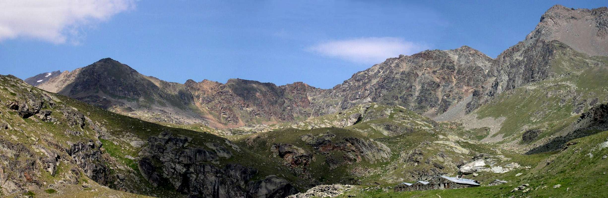
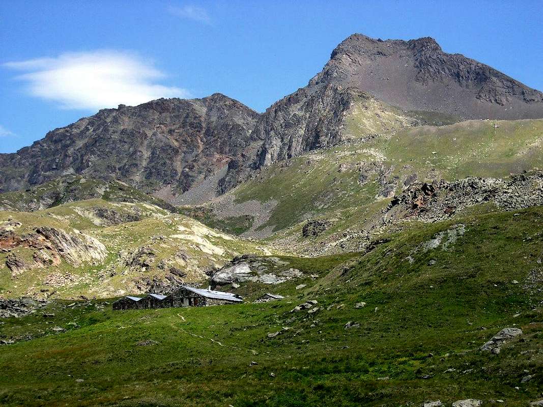
2) - The second is formed by a very little vallon between te Lower Lussert Loch (2.713m) and the Southwestern Slopes of Punta di Leppe (3.306m); a small grassy collar (2.769m) divide the same with the adjacent Corona Loch or Coronas (dedicated to mountaineer Giuseppe Corona, dedicated to that at the end of the nineteenth he crossed it first in winter descending to Saint Marcel into the Central Valley of Dora Baltea; 2.702m). On the Western side, a small and short ridge acts as a divider with the Alpe di Tsesère or Tszézeire (2.645m; beautiful wooden fountain near the pasture) , crossed by the homonymous torrent that comes, as an underground emissary, from the Lower Lake of Lussert. On the opposite side a more evident ridge formed by rocky spikes (South 2.779m, North 2.764m), which reach the previous collar (2.769m) towards the North, separates it from the Corona Lake, in turn below the Colle di Saint Marcel or of Corona (2.913m). This small valley, while to the North ends against the S-SE Wall of the Point of Lussert (3.221m) and to the Northeast against the Western Wall of the Pointe de Tsesère (3.108m); Southern appendix of the Punta di Leppe), towards South descends until you meet (2.520/30 meters about) the Torrent de Lussert, just above the Alpe di Grauson Nuove (2.540m), near which the new shelter was built, a substitute for the Bivacco Tentori which was burned down in June 2001. This deep and smal valley is generally used for grazing, while it is rarely frequented for hikers, preferring the most marked trails in the Northwest to the Lussert Lakes and to the Northeast towards the Frog's Loches (2.504m) , Corona and Col de Saint Marcel.
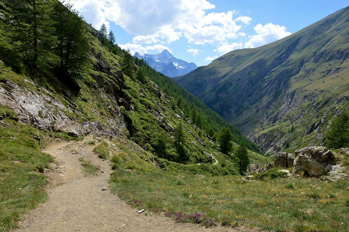
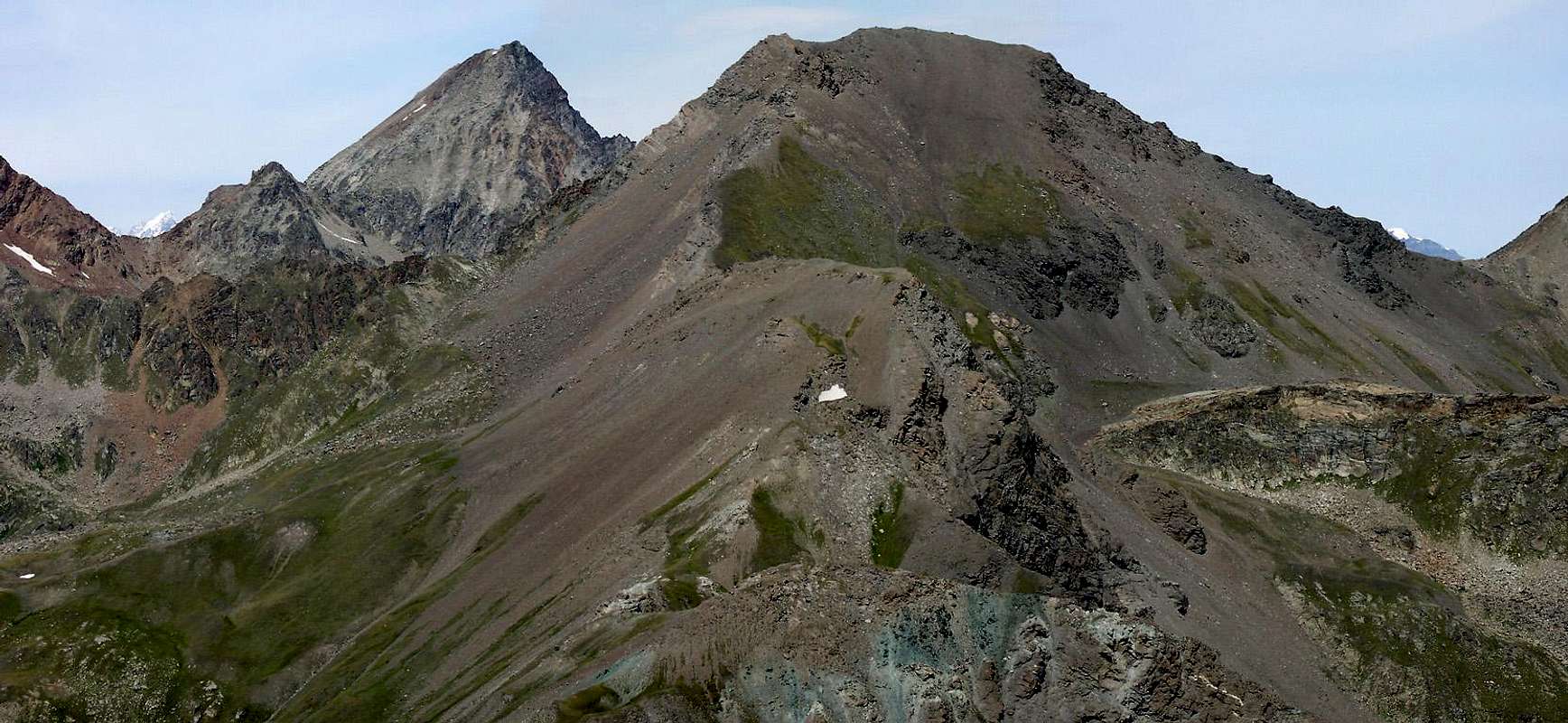
3) - The central zone (here shown in the first of the photos) that reaches the Punta di Leppe (to the Northeast) and the Hill of St. Marcel (to the East). This area acts as a trait d'union between the area of the four Lakes of Lussert and the furthest Vallone di Tessonet-Doreire which leads to the foot of the homonymous glacier and Punta Tersiva. in practice it originates from the first of the Lakes of Lussert or Inferiore also Lower (2.713/21m) to end with the Colle di Saint Marcel or Corona's, an important transit point between Cogne and the Central Valley of the Dora Baltea. It bears the name of Giuseppe Corona, who crossed it first in the winter of the end of the XIXth Century (see "Guidebook of Monte Emilius 1978", page 183) .Through it is still carried out today a procession which, starting from Cogne, reaches the Sanctuary of Plou or Plout (958m) above Saint Marcel and dedicated at the "Vierge de tous pouvoirs", but which was originally dedicated to "Notre Dame des Hermites".
4) - Branching to the right or Eastward to Punta Tersiva (to the East-southeast) and Pass Invergneux (to the Southeast). A sector, this one, which contains the Southern partition located between the Vallone di Grauson/Tessonet-Doreire and the Urtier's small Valley, immediately located in the East of the Fraction or Hamlet of Lillaz. In this stretch the two summits of Penne Blanche (Eastern 3.254m and more Western 3.205m) emerge and descends down as far as towards Monte Creya (3.015m). However, this sector is completely independent and moves Eastwards from the Lakes area of Lussert and, more to the East, "delle Rane" ("Loch of the Froggs"") and Corona or Corona's reaching those ones of Doreire. Treated already in a previous page, it originates from the junction that precedes Pralognan's Alp ((2.416m). These are four in number, located at the foot of the Tessonet-Doreire Glacier and the Punta Tersiva just as far as the Hevergnes Pass or Hevergnes's Col (Winter Hill). The same overlooks the homonymous mountain pasture (2.524m), which in the past was inhabited throughout the year.
Questi in sintesi i quattro settori del Vallone del Grauson:
1) - il settore dei Laghi di Lussert che flettendo a Nordovest raggiunge il Pas du Valaisan (verso Ovest) ed il Col des Laures (in direzione Nord). Questo lato più Occidentale del Vallone del Grauson prende inizio dal Lago Inferiore di Lussert, compreso tra l'arcigna piramide della Tour Grauson a Mezzogiorno e della Punta di Lussert (3.221 m) a Settentrione. Risalendo il medesimo s'incontrano gli altri tre laghi omonimi, posizionati alle pendici di una cerchia di rossicce montagne che dalla Tour Grauson raggiungono in successione la Punta Garin, il Mont Valaisan con l'omonimo Passo (3.210 m), le tre Punte Rosse dell'Emilius, la Punta di Laures con gli omonimi Colle e Mont. Da questo ultimo il divisorio con il Vallone delle Laures (Comune di Grand Brissogne) ritorna verso Oriente raggiungendo la Punta di Lussert e quella di Leppe, ormai al confine con la Valle di Saint Marcel.
2) - Il secondo risulta formata da un veramente minuscolo valloncello "incastrato" tra il Lago di Lussert Inferiore (2.713 m) e le pendici Sudoccidentali dellla Punta di Leppe (3.306 m); un piccolo collare erboso (2.769 m) lo divide dall'adiacente Lago Corona o Coronas (decicato all'alpinista Giuseppe Corona, che a fine dell'ottocento lo attraversò per primo in inverno scendendo a Saint Marcel nella Valle Centrale della Dora Baltea; 2.702 m). Sul lato Occidentale una minuscola e breve cresta funge da divisorio con l'Alpe di Tsesère o Tszézeire (2.645 m; bella fontana in legno nelle vicinanze della baita) , attraversata dal torrente omonimo che proviene , quale emissario sotterraneo, dal Lago Inferiore di Lussert. Sul lato opposto una cresta più evidente formata da spuntoni rocciosi (Sud 2.779 m, Nord 2.764 m), che raggiungono verso Settentrione il precedente colletto (2.769 m), la separa dal Lago Corona, a sua volta sottostante al Colle di Saint Marcel o di Corona (2.913 m). Questo piccolo vallone, mentre a Nord si conclude contro la Parete S-SE della Punta di Lussert (3.221 m) ed a Nordest contro la Parete Occidentale della Punta di Tsèsere (3.108 m); appendice Meridionale della Punta di Leppe), verso Meridione scende fino ad incontrare (2.520/30 metri circa) il Torrent de Lussert, appena al di sopra dell'Alpe di Grauson Nuove (2.540 m), presso la quale é stato costruito il nuovo rifugio, sostitutivo del Bivacco Tentori andato a fuoco nel Giugno del 2000.Questo valloncello in genere viene percorso ad uso pascolo, mentre raramente risulta frequentato con utilizzo a fini escursionistice preferendogli i più marcati sentieri a Nordovest verso i Laghi di Lussert ed a Nordest verso i Laghi delle Rane (2.504 m), Corona e Colle di Saint Marcel.
3) - la zona centrale (qui evidenziato dalla pima delle foto) che raggiunge la Punta di Leppe (a Nordest) ed il Colle di St. Marcel (decisamente ad Oriente). Questa area funge da trait d'union tra la zona dei quattro Laghi di Lussert ed il più lontano Vallone di Tessonet-Doreire che conduce ai piedi dell'omonimo ghiacciaio e della Punta Tersiva. in pratica si origina dal primo dei Laghi di Lussert od Inferiore (2.713/21 m) per terminare con il Colle di Saint Marcel o Coronas, importante punto di transito tra Cogne e la Valle Centrale della Dora Baltea. Porta il nome di Giuseppe Corona che lo attraversò per primo in un inverno della fine del XiX° Secolo (vedi "Guida del Monte Emilius 1978, pag. 183) . Attraverso lo stesso si effettua ancora oggigiorno una Processione che, partendo da Cogne, raggiunge il Santuario di Plou o Plout (958 m) al di sopra di Saint Marcel e decicato alla "Vierge de tous pouvoirs", ma che in origine era dedicato a "Notre Dame des Hermites".
4) - la ramificazione verso destra od Orientale verso la Punta Tersiva(all'estremo Est-sudest) ed il Pas d'Invergneux (più verso Sudest). Un settore, questo, che contiene il divisorio Meridionale posizionato tra il Vallone di Grauson/Tessonet-Doreire ed il Vallone dell'Urtier, collocato subito ad Oriente della Frazione di Lillaz. In questo tratto emergono le due sommità del Penne Blanche (Orientale 3.254 m e maggiormente Occidentale 3.205 m). Questo settore é però completamente indipendente e si allontana verso Est dalla zona dei Laghi di Lussert e "delle Rane" e Corona. Trattato già in una precedente pagina, esso si origina dal bivio che precede l'Alpe di Pralognan (2.416 m), raggiungendo il successivo nonché ultimo dell'Ervillières. Zona, quest'ultima, invece caratterizzata dalla presenza dei quattri Laghi Doreire, che si dispiegano ai piedi del Ghiacciaio di Tessonet-Doreiree della Punta Tersiva fino al Pas d'Invergneux oppure Col des Hevergnes' ("Colle d'Inverno o degli Inverni"). Lo stesso sovrasta l'omonimo alpeggio (2.524 m), che nei tempi passati era abitato per tutto l'anno.
Getting There from Cogne Municipality or from Gimillian Hamlet
BY CAR:
From TORINO, MILANO, etc: Motorway A5. Exit at IVREA or Quincinetto (PIEDMONT) AOSTA West/Aymavilles, Cogne Municipalities.From Aymavilles(646m) towards Cogne Valley: reacging Vieyes (1.132m), Epinel, Crétaz Hamlets to Cogne(1.534m); through Main Road. From this by Regional Road towards montroz and Gimillan(1.785m) Villages; from the last towards the above Grauson Vallon.
From FRANCE: through the Mont Blanc Tunnel to Entrèves-crossroads to Vény/Ferret Valleys - Mountain Guides of Courmayeur - La Saxe Rock Gym - Courmayeur. By Little Saint Bernard Hill, closed since November until half May to La Thuile Valley - Pré Saint Didier - Courmayeur. It is not necessary to take Motorway A5: you can drive on SS.26, in the direction of AOSTA - IVREA - TURIN.
BY PLANE:
Aeroporto "Corrado Gex" Saint Christophe (Aosta).
Seven recommended Routes
The most important & the recommended Hikes & Scrambles
1) - Pila Alp and Waterfall (2.221m, 2.250): walk from Gimillian (1.788m) with path n° 8/TVC in Northeast before towards Tarabouc, Révènti ruines and Tchezeu/Ecloseurs Alps (1.903m), after in North over Grua Torrent through a small deviation not reported and unnumbered to the Pila and nearby waterfall (2.021m) (E/F; 1h'20/1h'40).
2) - Ecloseur, Pila, Grauson Vieux and Nuove Alps, Frog's and Corona Lakes (1.903m, 2.221m, 2.273m, 2.500, 2.641m, 2.702m), Saint Marcel Hill (2.913m): excursion from Gimillian with various paths n° 8/TVC/8A/102 before in North, after by Grauson Nuove in East-northeast with trail n° 8B/102 (E/F; 4h'00/4h'30). With Variant more to the West passing near Tsesère Alpage and crossing through the Collar (2.769m) by the new connection route E/F; 4h150/4h'45).
3) - Gimillan to St. Marcel Hill (2.913m): excursion-climbing from hill in North to two Laval Summits and Punta Gianni Vert (3.091m, 3.099m, 3.150m) through traverse on easy ridge (E/F; 5h'30/6h'00). With the same variation (E/F; 5h'45/6h'15).
4) - Grauson Nuove and Tsezéire Alps, Vallonet Pass (2.540, 2.645m, 3.062m) to Punta di Leppe (3.305/6m): quite excursion or, really wanting, with very brief ad easy climbing (I°/II° on thread of ridge) from Gimillian very ancient Village with various trails n° 8/TVC/8A/102 before in North, after in Northeast with path unreported to Western Slope of pass and East-southeast Crest (Normal Via to Summit from Cogne or Gimillan) in terminal part (EE/F; 5h'00/5h'30).
5) - Grauson Nuove and Tsezéire or Tsesère Alps, Vallonet Pass or, better, Vallonet's Collar (2.540, 2.645m, 3.062m) towards Punta di Leppe (3.305/6m): classic and fairly frequented hike even (really wanting to run) with short strechts of climbing from Gimillian very old Hamlet, with various trails n° 8/TVC/8A/102 before in North, after in Northeast with path unreported towards the Western Slope of small collar and East-southeast Crest (Standard Via from Gimillan) through mini path often covered by grass in terminal part (EE/F; 5h'00/5h'30). Or with brief deviation from the mini path towards Vallonet's Collar (3.062m) in altidude around 2.950 meters to the North-northwest reaching Pointe Tsesère (3.108m), through large and steep moraine and easy small rocks covered with grass in terminal part (EE/F+; 5h300/6h'30).
6) - Grauson Nuove and Tsezéire Alps Lussert Pass or Lussert's Collar (2.540m, 2.645m, 3.181m) towards Punta di Leppe (3.305/6m): busy excursion or really delicate climbing because of the rock for nothing good from Gimillian Hamlet with various trails n° 8/TVC/8A/102 before in North along Torrent Grua, after in Northeast passing nearby Torrent Lussert with path unreported towards the Southern Slope of pass and:1) - Western steep Edge in terminal part (around 125/30 meters) with brocken and rotten rocks (fragile and delicate route; EE/F; 6h'00/6h'30); 2) - doubling the same in North and through the even snowy Northwest Face and with more easy route (30°/35°) Slope EE/F; 5h'00/5h'30).
7) - Grauson Nuove and Tsezéire Pastures to Lussert Pass or Collar (2.540, 2.645m, 3.181) towards Punta di Lussert (3.221m): excursion-climbing from Gimillian Hamlet with various trails n° 8/TVC/8A/102 before in North, after in Northeast with path unreported towards Southern Slope of Collar (3.181m) and: 1) - Eastern short Crest in terminal part with boulders and rotten rocks ( EE/F; 6h'00/6h'30); 2) - directly to the North and through the South-southeast Wall, more difficult and exposed to stone falls (enough dangerous route; via in existance but surely no recommended EE/F; 5h'00/5h'30).
Campings
Remember that free camping is forbidden (except for emergency reasons, over 2.500m, from darkness until dawn).
Mountain Condition
Meteo: you can find all the needed informations at the official site of the Valle d'Aosta Region:
"Guida delle Alpi Occidentali" di Giovanni Bobba e Luigi Vaccarone C.A.I. Sezione di Torino Volume II (parte II), 25 Maggio 1896.
"Guida dei Monti d'Italia Emilius Rosa dei Banchi Parco del Mont Avic" di Giulio Berutto e Lino Fornelli - Club Alpino Italiano/Touring Club Italiano, Marzo 2005.
MAPS:
Kompass "Gran Paradiso Valle d'Aosta Sentieri e Rifugi" Carta Turistica 1:50.000.
Hapax "Les Sentiers Comunità Montana Monte Emilius", Luglio 2000 1:25.000.
Enrico Editore Ivrea-Aosta "Gruppo del Gran Paradiso" 1:50.000.
I.G.C. Torino "Carta delle Passeggiate ed Escursioni in V.D.A. Conca di Pila-Gressan" 1:20.000.
L'Escursionista "Valle di Cogne Carta dei Sentieri" (n° 10) 1:25.000.
L'Escursionista "Tour de la Vallée de Cogne Grand Paradis" Carta dei sentieri 1:25.000.
Children refers to the set of objects that logically fall under a given object. For example, the
Aconcagua mountain page is a child of the 'Aconcagua Group' and the 'Seven Summits.' The
Aconcagua mountain itself has many routes, photos, and trip reports as children.
Parents refers to a larger category under which an object falls. For example, theAconcagua mountain page has the 'Aconcagua Group' and the 'Seven Summits' asparents and is a parent itself to many routes, photos, and Trip Reports.


 1536 Hits
 79.78% Score
 11 Votes