
-
 6977 Hits
-
 81.18% Score
-
 13 Votes
|
|
Mountain/Rock |
|---|---|
|
|
45.58230°N / 7.50521°E |
|
|
9905 ft / 3019 m |
|
|
Overview
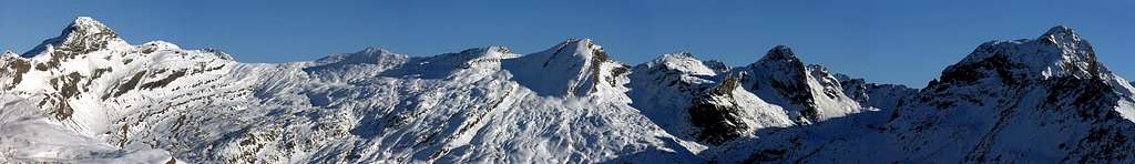
Little summit of the dividing crest Urtier Valley-Val Soana, positioned on the axle watershed in sense East/West that from the Rosa of the "Rocky Benches" (3.164m) it lengthens toward the Tower of Lavina (3.308m), among the Pass of the Balma (2.941m) to East and a series of Quotas (2.974m, 2.987m, 2.991m) to West and said Black Rocks of Peradzà. From one Oriental Shoulder of his or Quota 3.006m goes down toward North a great crest that, after an important Saddle 2.946m to connect the Vallone of the Urtier (Cogne Valley) to that of the Miserin (Champorcher Valley), road doing raises again him to the Bec Costazza, to the Towers Ponton and Pontonnet, to the beautiful pyramid of the Tersiva (3.515m) and to the Pointe du Tessonet. From this point, undoubling herself, it goes to form the Group of the Emilius (3.559m) - Great Roise (3.357m) I pour Northwest and that of the Grand Avert (2.991m) - Mont Corquet toward North, both confluent ones in the Central Valley of the Dora Baltea Stream near the City of Aosta. Good, popular vista point, attended for the Ski-Mountaineering; Good belvedere very frequented for the ski-mountaineering, trip that with the opening of the Shelter Sogno du Berdzè (2.537m), near the old Alp of Peradzà, it results more and more frequented being of easy as well as brief ascent. But it is also achieved by starting from Dondena (2.110m) Champorcher Valley or just after from the Refuge Dondena (2.186m) or from the Lake Miserin (2.578m; Sanctuary and Shelter), through the long walloon that leads to Colle della Balma (2.941m) or directly via the nearby Saddle 2.946 meters, then concluding with the easy Northeast Crest in the last part. This easy Summit is open to different crossings, starting from the North by Fenêtre de Champorcher, East Hills from Rose and Balma and generally downhill, through the West Ridge to the Black Rocks of Peradzà (2.991m) and the underlying Saddle 2.963 meters before the Tête de la Nouva (3.031m). We have, for example, some proposals for the "First Ascents".
Piccola Sommità della cresta divisoria Valle dell'Urtier-Val Soana (quest'iltima in Piemonte), posizionata sull'asse spartiacque in senso Est/Ovest, che dalla Rosa dei Banchi (3.164 m) si allunga verso la Torre di Lavina (3.308 m), tra il Colle della Balma (2.941 m) ad Oriente ed una serie di Quote (2.974 m, 2.987 m, 2.991 m) ad Ovest e dette Rocce Nere di Peradzà. Da un suo spallone Orientale o Quota 3.006 m scende verso Settentrione una grande cresta che, dopo un'importante Sella 2.946 m atta a collegare il Vallone dell'Urtier (Valle di Cogne) a quello del Miserin (Valle di Champorcher), strada facendo, si rialza al Bec Costazza, alle Torri Ponton e Pontonnet, alla bella piramide della Tersiva (3.515 m) ed alla Costa e Pointe du Tessonet. Da questo punto, sdoppiandosi, va a formare il Gruppo dell'Emilius (3.559 m), Grande Roise (3.357 m) a Nordovest e quello del Grand Avert (2.991 m), Mont Corquet con le biforcazioni a Settentrione verso il Mont Roux (Miniere di Servette-Chuc) ed il Mont Saint Julien verso Nordest, entrambe confluenti nella Valle Centrale della Dora Baltea nei pressi di Aosta Città. Ottimo belvedere molto frequentato per lo Sci-Alpinismo; gita che con l'apertura del Rifugio Sogno du Berdzè (2.537 m), presso la vecchia Alpe di Peradzà, risulta sempre più frequentata essendo di facile, nonché breve salita. Ma viene raggiunta anche dalla Valle di Champorcher partendo da Dondena, dal Rifugio di Dondena o dal Lago Miserin (2.578 m Santuario/Rifugio) percorrendo il vallone che porta al Colle della Balma (2.941 m) o direttamente tramite la vicina Sella (2.946 m), concludendo poi tramite la facile Cresta Nordest. Questa Sommità si presta a diverse traversate partendo da Nord dalla Fenêtre de Champorcher, da Est dai Colli della Rosa e della Balma e, generalmente in discesa, con la Cresta Ovest verso le Rocce Nere di Peradzà (2.991 m) e la Sella 2.963 metri prima della Tête de la Nouva (3.031 m). Ne abbiam, a titolo esemplificativo, proposte alcune in "First Ascents".
First Ascent
- First in the summit: Unknown.
- In winter: Unknown.
- Great Traverse from Champorcher Fenêtre - Bec Costazza, by NW Ridge - Saddle 2.946m - Cima di Peradzà - Black Rocks of Peradzà - Saddle 2.963m: Osvaldo Cardellina and Emilio Bertona, (Jul 13th, 2000).
- Traverse Bec Costazza - Saddle 2.946m - Cima Peradzà with direct descent by NW Slope: Osvaldo Cardellina, Emilio Bertona and Gianfranco Vicentini, (Jul 16th, 2000).
- Traverse Bec Costazza, by W Face - Saddle 2.946m - Cima Peradzà - and direct descent by N Edge: Osvaldo Cardellina and Emilio Bertona, (Oct 19th, 2003).
- Traverse Saddle 2.946m - Cima of Peradzà - Black Rocks of Peradzà - Saddle 2.963m: Felice Bechon and Company, (Summer 2004?).
- Integral Crossing from Bantses Valley Rosa Pass – Asgelas Point – Corona Point – Balma Pass – Peradzà Point – Saddle 2.946m - Miserin Lake: Osvaldo Cardellina and Emilio Bertona, (Jul 22th, 2007), in day from Dondena Village.
Getting There
BY CAR:- From Torino, Milano, etc: Motorway A5. Exit at Aosta Ovest. Drive to the near Aymavilles. Follow the directions for Valle di Cogne.
- From Switzerland: through the Grand Saint Bernard Tunnel or the namesake Pass. Drive to Aosta, then follow the direction for Courmayeur on SS.26. Just after Sarre, turn to the left, in the direction of Valle di Cogne.
- From France: through Mont Blanc Tunnel or Petit St. Bernard Pass. It isn't necessary to take Motorway A5: you can drive on SS.26, in the direction of Aosta.Before arriving at the Village of Sarre, turn right following the sign for Valle di Cogne. After Aymavilles, the SR.47 crosses the Villages of Vieyes, Epinel and Cretaz and after about 25 Km arrives at Cogne (1.534m). From Cogne you can get the Village of Lillaz (1.617m).
- Aeroporto "Corrado Gex" Saint Christophe (Aosta).
Approach
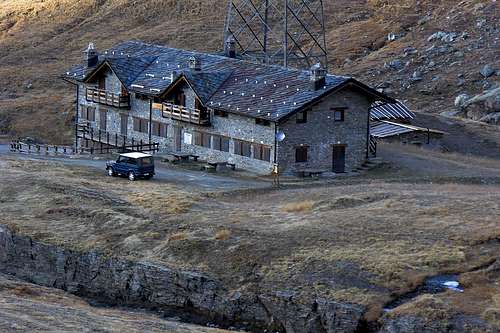
Dall'abitato di Cogne (1.534 m) in bus o in auto raggiungere la ridente frazione di Lillaz (1.617 m), dove si parcheggia l'auto nel grande piazzale sito quasi al centro del villaggio. Percorrere il sentiero n° 13 Alta Via n° 2 al disotto della strada poderale fino alle Baite di Gollies Dessus (1.869 m; bella fontana in un grande tronco); continuare lungo la strada poderale concomitante con il sentiero segnato n° 10/Alta Via n° 2 fino alla Chiesetta di Crêt (2.020 m; fontana), ben visibile dal basso, e oltrepassati la Cascata del Tsavanis nonché gli Alpeggi di Tsavanis (2.296 m; fontana) e La Manda (2.370 m), si raggiunge il Rifugio Sogno du Berdzé (2.537 m; Sogno del Pastore; E; 3h'30/3h'45 da Lillaz).
Routes Description from Sogno of Berdzé Shelter
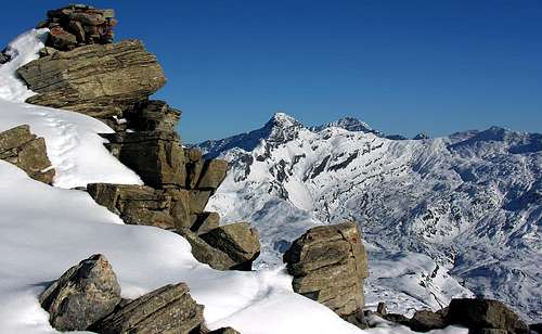
ROUTE FROM NE SLOPE From the Shelter Sogno of Berdzé (2.526m) through the Saddle 2.946m): after having forded the Torrent of Peradzà, going down on the same medium a short rocky passage, to follow verse if the fund of the vallone for pastures and slant with separate rocky banches among them from different rivulets in the Bassa (Low) one of Peradzà and overcoming the sundry rocky prominences of it. To continue the slope leaving aloft and on the left (East) an oblique rocky band of greater dimensions progressively revolving her with a turn to semicircle toward Southeast; in the final part and decidedly with direction toward rising through alternate rocky "banconate" on the higher part of Bassa di Peradzà to snowy slant to reach the wide one (2.946m, suffered to South of the point of his greater depression. From this point I am possible two solutions:1) - to directly aim toward the top through the Northern Slope; from the Saddle 2.946m to climb slightly moving himself on the right in direction of a small rated promontory 2.969m, reached which or for a slant of snow (30°) or on easy emergent small rocks is reached the Peak, on which a metallic stud of the C.A.I is systematized. of Rivarolo.
2) - or to continue with the same characteristics of run and peer difficulty above the Crest to reach Its Quota 2.978m (important topographical knot, see Overview) watershed situated between the Vallonis of the Urtier-Peradzà and the tall Vallone of the Miserin. To insert him so on the Crest it is, coming from the Pass of the Balma (2.941m), and changing completely direction toward West, to overcome in succession the two quotas 3.006m and 2.989m with easy run on the thread of the crest or as soon as under the same one to North, that separates the Vallone Urtier-Peradzà from that of Campiglia Soana in Piedmont (E; F; 1h'20/1h'45).
 |
 |
 |
 |
Dal rifugio Sogno di Berdzé (2.526 m) tramite la Sella 2.946 m: dopo aver guadato il Torrent de Peradzà, scendendo sullo stesso tramite un corto passaggio roccioso, seguire verso Sudest il fondo del vallone per pascoli e pendii con banconate rocciose separate tra loro da diversi rigagnoli nella Bassa di Peradzà e superandone i varii risalti rocciosi. Proseguire la salita lasciando in alto e sulla sinistra (Est) una fascia rocciosa obliqua di maggiori dimensioni aggirandola progressivamente con un giro a semicerchio verso Sudest; nella parte finale e decisamente con direzione verso levante nella parte alta della Bassa di Peradzà tramite banconate rocciose alternate a pendii nevosi raggiungere la larga Sella (2.946 m), subito a Sud del punto di sua maggiore depressione. Da questo punto sono possili due soluzioni:
1) - puntare direttamente verso la cima tramite il pendio Settentrionale; dalla Sella 2.946 m salire spostandosi leggermente sulla destra in direzione di un piccolo promontorio quotato 2.969 m, raggiunto il quale o per un pendio di neve (30°) o su facili roccette emergenti si raggiunge la Vetta, sulla quale é sistemata una borchia metallica del C.A.I. di Rivarolo.
2) - oppure continuare con le stesse caratteristiche di percorso e pari difficoltà sopra la Cresta Nordest raggiungere la Quota 2.978 m (importante nodo topografico, vedi Overview) facente da spartiacque tra i Valloni dell'Urtier-Peradzà e l'alto Vallone del Miserin. Inserirsi così sulla Cresta Est, proveniente dal Colle della Balma (2.941 m), e cambiando completamente direzione verso Ovest, superare in successione le due quote 3.006 m e 2.989 m con percorso facile sul filo della cresta oppure appena sotto la stessa a Nord, separante il Vallone Urtier-Peradzà da quello di Campiglia Soana in Piemonte (E; F; 1h'20/1h'45).
3) - From Sogno of Berdzé Hut through the Saddle 2.963m and West Ridge also called "Black Rocks" of Peradzà Crest: from refuge return West-southwest direction and by dirt road to at beginning of path n° 13, High Route n° 2, TVC, in quota 2.469m and from this by a short diagonal to West-southwest reach the crossroads 2.468m (E; 0'15); from fork, near Nouva Torrent, go up before North-northeast, after North by path n° 13b/13C contra and below the quota 2.530m, nearby various little torrents, descending from Gratton Coastline, and over a tiny lake; here Southwest cross the torrent and, by two large hairpin winding, from Peradzà Bassa (= Low Promontory) to Gratton Coastline. Leaving below the quota 2.641m the deviation (path n° 13C to Southwest) towards Miserino Valley and splendid Lakes, go up, South-southeast direction, by a splendid and very ancient mule-track towards Arietta Pass (2.947m); abandon even this in quota 2.800/50m~ and, no obliged route (traces on soil), doubling East the North-northwest Buttress, from Tête de la Nouva (Head of New Route) descending. Cross the whole Northern Slope, by a small debris trace in diagonal East-southeast ascent, reaching the large Saddle 2.963m. From this to begin the slope along the East-northeast Crest overcoming on the thread a rocky jump of about fifty meters (III°III°+ on the thread of crest or II°/II°+ with avoidances to Northwest), otherwise through a ledge of deposits revolt to North which they follow small walls alternated to terraces with gravel. To reach the Quota 2.993m and the following 2.991m, the most elevated of the "Black Rocks" of Peradzà; to continue changing the direction in Eastsoutheast actually to the Quota 2.987m and always with the sharp crest and exposed, above all toward South (II°/II°+), to reach the last Quota 2.974m. Through the Crest West of the Point of Peradzà and without other problems to reach the Peak (EE/A; 1h'15/1h'30 from the Saddle 2.963m; 2h'30/3h'00 from the Hut of Peradzà).
 |
 |
 |
 |
3) - Dal rifugio Sogno di Berdzé (2.526 m) tramite la Sella 2.963 m e la Cresta Ovest o delle "Rocce Nere" di Peradzà: dal rifugio tornare indietro verso Ovest-sudovest con la poderale sino a quota 2.469 m, ove si diparte il sentiero n° 13, Alta Via n° 2, TVC e, tramite questo, raggiungere con un breve diagonale indirizzato ad Ovest-sudovest raggiungere il bivio 2.468 m (E; 0'15); dall'incrocio, presso il Torrente de la Nouva, salire verso Nord-nordest prima e Nord dopo con il sentiero n° 13B, 13C sin sotto la quota 2.530 m, presso numerosi torrentelli provenienti dalla Cote Gratton ed un piccolo laghetto dabbasso; qui attraversare verso Sudovest il torrente portandosi con due larghi tornanti dalla Bassa di Peradzà alla soprastante Cote Gratton. Abbandonata sotto la quota 2.641 m la deviazione (sentiero n° 13C verso Sudovest) per il Vallone ed i bei laghi del Misurino, risalire verso Sud-sudest con la splendida ed antichissima mulattiera del Colle dell'Arietta (2.947 m); lasciare anche questa a quota 2.800/50 m~ e, senza percorso obbligato (tracce) doppiare verso sinistra (Est) il costolone Nord-nordovest che scende dalla Tête de la Nouva. Tagliare su di una piccola traccia tra detriti con salita diagonale verso Est-sudest tutto il Versante Settentrionale raggiungendo la larga Sella 2.963 m Da questa inizire la salita lungo la Cresta Est-nordest superando sul filo un salto roccioso di una cinquantina di metri (III°III°+ sul filo di cresta, oppure II°/II°+ con aggiramenti a Nordovest), altrimenti tramite una cengia di detriti rivolta a Settentrione alla quale fanno seguito piccoli muri alternati a terrazze con ghiaia. Raggiungere la Quota 2.993 m e la successiva 2.991 m, la più elevata delle "Rocce Nere" di Peradzà; continuare cambiando la direzione in Est-sudest sino alla Quota 2.987 m e sempre con la cresta affilata ed esposta, soprattutto verso Sud (II°/II°+), arrivare all'ultima Quota 2.974 m. Tramite la Cresta Ovest della Punta di Peradzà e senza altri problemi raggiungere la Vetta (EE/A; 1h'15/1h'30 dalla Sella 2.963; 2h'30/3h'00 dal Rifugio di Peradzà).
Difficulties
This route can be considered E/EE/F/II°+.Da escursionismo.
Campings
There are plenty of camping sites along the Gran Paradiso valleys. Remember that free camping is forbidden (except for emergency reasons, over 2.500m, from darkness until dawn).Huts
 |
Mountain Condition
- Meteo: you can find all the needed informations at the official site of the Valle d'Aosta Region:
- Valle d'Aosta Meteo
Webcam
- WEBCAM on Aosta Valley:
- Webcam
Books and Maps
BOOKS:
- "Guida dei Monti d'Italia–Emilius Rosa dei Banchi Parco del Mont Avic" di Giulio Berutto e Lino Fornelli-Club Alpino Italiano/Touring Club Italiano, Marzo 2005 (in Italian).
- "I Rifugi della Valle d'Aosta" di Stefano Ardito, Ed. Guide iter, Febbraio 2003.
- "Diari Alpinistici" di Osvaldo Cardellina e Indice Generale accompagnato da Schedario Relazioni Ascensioni 1964-2019 (inediti).
 |
 |
 |
MAPS:
- Enrico Editore Ivrea-Aosta "Gruppo del Gran Paradiso" 1:50.000.
- L'Escursionista "Valle di Cogne Carta dei Sentieri" 1:25.000.
 |
 |
Important Information
- REGIONE AUTONOMA VALLE D'AOSTA the official site.
- FONDAZIONE MONTAGNA SICURA Villa Cameron, località Villard de la Palud n° 1 Courmayeur (AO) Tel: 39 0165 897602 - Fax: 39 0165 897647.
- SOCIETA' GUIDE ALPINE DI COGNE Tel. 347/9473526 – 328/1373728.
- A.I.NE.VA. (Associazione Interregionale Neve e Valanghe).
- A.IA.T. Cogne Gran Paradis via Bourgeois n° 34 Tel. 0165-74040. E-mail: aiat@cogne.org
- Ezio Sport articoli sportivi - via Bourgeois n° 64 Tel. 0165-74204.
Useful Numbers
- Soccorso Alpino Cogne (SAR) Tel. 3482685406.
- Protezione Civile Valdostana località Aeroporto n° 7/A Saint Christophe (Ao) Tel. 0165-238222.
- Bollettino Meteo (weather info) Tel. 0165-44113.
- Unità Operativa di Soccorso Sanitario Tel. 118.
External Links
- P.N.G.P. official site It's the official site of the Parco Nazionale del Gran Paradiso (in five languages)
- parco.nazionale.gran.paradiso Another complete site concerning the Gran Paradiso National Park, with a lot of information (in three languages).