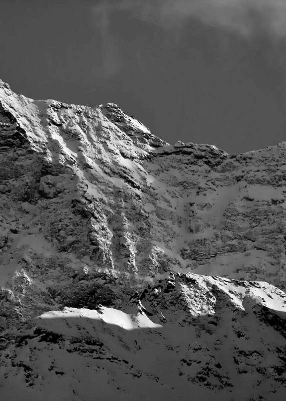
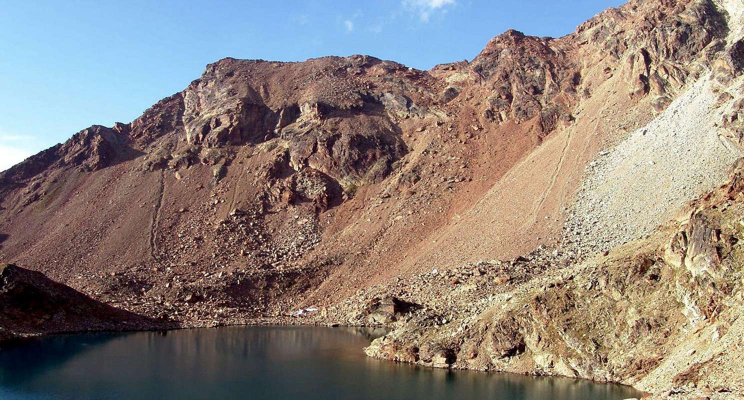
This tiny Summit emerges on Western Ridge of Mount Emilius that, after an initial steep section, reaches the same. Beyond the ridge continues Westward reaching the Summit of Mont Ròss de Comboé (3.285m), where it splits with one branch going down towards Northwest towards Col Carrel (2.912m) and a second South-southwest in the direction of the ridge separating the Vallons of Arbolle and Comboé (Col Ròss, Punte del Lago Gelato, Col de Comboé, Trident de Arbolle). Very rarely it achieved in the past, although it recorded a first winter ascent, currently knows a good attendance as an intermediate transit point on the "Via Ferrata" at the Federigo Camp Zullo (2.907m) at the Colle Carrel. On the Northern side has a steep wall of over 450 meters above the Western Arpisson Glacier. The same has been climbed on a single occasion in 1897 in an attempt to go in the first ascent of the North Wall Monte Emilius (3.559m) having to settle for this "trick" with exit to the East of the Little Emilius to altitude of 3.420/30 meters about. It is no longer repeated, also for its dangerousness being somewhat exposed to falling stones. A Southern presents instead a much shorter slope that rises above Lake Gelato (2.956m); the same is split into two parts with a small Wall Southwest still unclimbed, and, after a Southern Edge climbed on a single occasion in 1968, a slope of scree and easy downhill debris in 1911. But the first absolute ascent should be made by the Abbé Marie Joseph Henry with Charvensod Mountain Guide Grégoire Comé September 17th, 1902 and September 20th following repeated by Felice Mondini and Enrico Questa, departing directly from Aosta Town and unaware of the previous ascent by Henry-Comé, carried out a few days before starting by Charvensod Hamlet. A double exploit in a very short time followed by a long silence until the '40s, with the first winter of the Trieste Nerino Gobbo winter of 1940/41 and the crossing downhill by the Mountain Bearer Giulio Adolfo Ourla said "Dulo" with his wife Aurora Wuillerminaz 20th July 1941. So another long silence until the 60's/70.
Questa minuscola punta emerge sulla Cresta Ovest del Monte Emilius che, dopo un primo tratto più ripido, caratterizzato da un "Salto Grigio" e da una serie di "Torri Rosse" la raggiunge. Oltre la cresta spartiacque continua verso Occidente raggiungendo la Vetta del Mont Ròss de Comboé (3.285 m), dove si sdoppia con un ramo che scende verso Nordovest in direzione del Bivacco Federigo Zullo al Col Carrel (2.912 m) ed un secondo a Sud-sudovest in direzione del crestone che separa i Valloni di Arbolle e Comboé partendo nei pressi dei due laghi e del Rifugio d'Arbolle (2516 m: Mont Ròss de Comboé, Col Ròss, Punte del Lago Gelato, Col de Comboé, Trident de Arbolle). Molto raramente raggiunto nel passato, anche se fa registrare una prima ascensione invernale, attualmente conosce una discreta frequentazione come punto di transito intermedio sulla Via Ferrata dal Bivacco Federigo Zullo (2.907 m) presso il Colle Carrel (2.912 m). Sul lato Settentrionale presenta una ripida parete di oltre 450 metri sopra il Ghiacciaio Occidentale dell'Arpisson; la stessa è stata salita in un'unica occasione nel 1897 in un tentativo di percorrere in prima ascensione la Parete Nord del Monte Emilius (3.559 m) dovendosi accontentare di questo "escamotage" con uscita ad Oriente del Piccolo Emilius a quota 3.420/30 metri circa. Non risulta più ripetuta, anche per la sua pericolosità essendo alquanto esposta alla caduta di pietre. A Meridione presenta invece un versante molto più breve che si innalza sopra al Lago Gelato (2.956 m); lo stesso si sdoppia in due parti con una piccola Parete Sudovest ancora inviolata e, dopo uno Spigolo Sud salito in un'unica occasione nel 1968, un versante detritico e facile, percorso in discesa nel 1911. Ma la prima ascensione assoluta dovrebbe essere quella realizzata dall’Abbé Marie Joseph Henry con la Guida di Charvensod Grégoire Comé il 17 Settembre 1902 e ripetuta il 20 Settembre appresso da Felice Mondini ed Enrico Questa, con partenza direttamente dalla Città d'Aosta nonché ignari della precedente salita Henry-Comé, effettuata pochi giorni prima partendo dal Villaggio di Charvensod. Una doppia impresa in un tempo molto breve seguita da un lungo silenzio fino agli Anni '40 con la prima invernale del triestino Nerino Gobbo nel 1940/41 e la traversata in discesa del portatore Giulio Adolfo Ourla detto "Dulo" con la moglie Aurora Wuillerminaz il 20 Luglio 1941. Quindi, dopo una visita in discesa dall'Emilius il 12 Settembre 1911, un altro lungo silenzio fino agli Anni '60/70 con la salita solitaria dello Spigolo Sud nel 1968 e con varie traversate nel 1974, 1976, 1977 e seguenti lungo il Contrafforte Sud-sudovest, dal Col Ròss o dal Carrel. Prima della "Via Ferrata", della posa del Bivacco Federigo e del Rifugio d'Arbolle. Sempre partendo dal Comprensorio di Pila.
First Ascents
First on the Summit: Abbot Marie Joseph Henry with Charvensod Mountain Guide Grégoire Comé, (Sep 17th 1902); second ascent by Felice Mondini and Enrico Questa (C.A.I. Ligurian Section), (Sep 20th, 1902).
In winter: Nerino Gobbo, (1940/41).
North Wall: Ercole Daniele and Giovan Battista Devalle (C.A.I. Turin) with Valtournanche Mountain Guides Louis Bich and Anselme Pession, (Aug 30th, 1897), in ascent from Arpisson Alp.
Southern Slope (Normal Route): Giovan Battista Bozzino and Carlotta "Tina" Bozzino, (Sep 12th, 1911), in descent.
South Edge: Osvaldo Cardellina, lone, (Oct 13th 1968), from Lago Gelato after the ascent and descent on Mont Emilius.
Getting There
BY CAR:
From TORINO, MILANO, etc: Motorway A5. Exit at IVREA or Quincinetto (PIEDMONT).
From IVREA Town: before in West (Southern side) to Pont Saint Martin, Verrès, Saint Vincent, Chatillon, Nus, Aosta East (A5 exit).
From FRANCE: through the Mont Blanc Tunnel to Entrèves/Courmayeur. By Little Saint Bernard Pass, closed since November until half May.
SPECIFIC ROAD:
From Aosta City before to the South, crossing Dora Baltea, towards Le Pont Suaz and Charvensod Commune, after in East and Southwest towards Peroulaz, Les Fleurs, Rosselin, Grande Cerise Villages until Pila Resort.
BY PLANE:
Aeroporto "Corrado Gex" Saint Christophe (Aosta).
Approach with relative Route
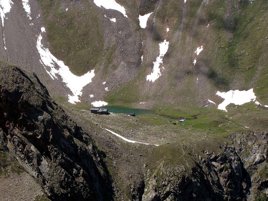
From Pila through Arbolle Valley: from Pila Resort (famous and crowded ski resort just above Aosta - Cableway or Bus service), to the Chamolé Lake (2.311m), using chairlift or on foot, and on to the homonymous pass (2.641m), through it go down to the new (built in 1998) and comfortable Arbolle Refuge (2.510m) with a large mule track and path n° 16/TVC above the Arbolle Lake with it effluent. After continue towards East and South, with the same route n° 14 for the Monte Emilius (3.559m), till the Lago Gelato (2.956m). From this point back to the North, no path and nor traces, towards the overlying stony that progressively increases in steepness until it reaches the watershed immediately to the East of the Little Emilius. At first go directly to the reddish morain leaving on the right (East) that gray which climbs towards Monte Emilius; then bend with a curved path to the left (Northwest) reaching the West Ridge or current (since 2004) Via Ferrata. For the easy East Crest soon to Peak (EE A/ F/F+; 3h'30/4h'00 from Pila Resort; 2h'00/2h'15 from Arbolle Shelter; 1h'00/1h'15 by Lago Gelato).
Da Pila per il Vallone dell'Arbolle: dalla località di Pila (noto comprensorio sciistico, raggiungibile da Aosta in auto pullman o funivia), pervenire al soprastante Lago di Chamolé (2.311 m; anche qui in seggiovia o a piedi tramite vari sentieri), e l'omonimo colle superiore (2.641 m), per il quale si scende al comodo Rifugio Alpe di Arbole (2.510 m) tramite mulattiera n° 16/TVC. Quindi dirigersi dapprima verso Est e poi Sud con la stessa via e sentiero n° 14 per il Monte Emilius fino al Lago Gelato (2.956 m). Da questo punto risalire con direzione Nord, senza sentiero né traccia alcuna, verso la soprastante pietraia, che progressivamente aumenta in ripidezza, sino a raggiungere lo spartiacque subito ad Oriente del Piccolo Emilius. Dapprima salire direttamente sulla morena rossiccia lasciando sulla destra (Est) quella grigia che sale verso il Monte Emilius; poi flettere con percorso arcuato verso sinistra (Nordovest) raggiungendo la Cresta Ovest od attualmente (dal 2004) Via Ferrata. Per la facile Cresta Est in breve tempo alla Vetta (EE A/ F/F+; 3h'30/4h'00 da Pila; 2h'00/2h'15 dal Rifugio di Arbolle; 1h'00/1h'15 dal Lago Gelato).
Difficulty
This route can be considered EE/F for the Southern Slope and EEA/F+ for the small Eastern Crest.
L'itinerario è da classificare in EE/F per il Versante Sud nonché EEA/F+ per la Crestina Est.
"Guida del Monte Emilius", di Osvaldo Cardellina Editore in collaborazione con il Club Alpino Italiano Sezione di Aosta, Dicembre 1978.
"Guida dei Monti d'Italia – Emilius Rosa dei Banchi Parco del Mont Avic" di Giulio Berutto e Lino Fornelli - Club Alpino Italiano/Touring Club Italiano, Marzo 2005.
"Guida delle Alpi Occidentali" di Giovanni Bobba e Luigi Vaccarone C.A.I. Sezione di Torino Volume II (parte II), 25 Maggio 1896.
"Diari Alpinistici" di Osvaldo Cardellina e Indice Generale accompagnato da Schedario Relazioni Ascensioni 1964-2019 (inediti).
MAPS:
Kompass "Gran Paradiso Valle d'Aosta Sentieri e Rifugi" Carta turistica 1:50.000.
L'Escursionista "Conca di Aosta-Pila-Monte Emilius" Carta dei sentieri (n° 4) 1:25.000.
Hapax "Les Sentiers Comunità Montana Monte Emilius", Luglio 2000 1:25.000.
Enrico Editore Ivrea-Aosta "Gruppo del Gran Paradiso" 1:50.000.
I.G.C. Istituto Geografico Centrale, Torino "Carta delle Passeggiate ed Escursioni in V.D.A. Conca di Pila-Gressan, 1:20.000.
Parents refers to a larger category under which an object falls. For example, theAconcagua mountain page has the 'Aconcagua Group' and the 'Seven Summits' asparents and is a parent itself to many routes, photos, and Trip Reports.

 3232 Hits
 85.36% Score
 20 Votes