


-
 3799 Hits
-
 81.84% Score
-
 14 Votes
|
|
Mountain/Rock |
|---|---|
|
|
45.65920°N / 7.37602°E |
|
|
Cogne Valley, Charvensod Municipality |
|
|
Mountaineering, Trad Climbing |
|
|
Spring, Summer, Fall |
|
|
10850 ft / 3307 m |
|
|
Note
La montagna chiama i suoi figli, ed essi rispondono fedelmente al suo appello… Osvaldo Cardellina, Diario alpinistico, 1964-65 Page texts: @ OsvaldoCardellina "Osva", passed away on May 2, 2022. Page owners: Christian Cardellina e Osvaldo Cardellina. Any updates from September 12, 2022: Antonio Giani, page administrator, friend and climbing companion. Testi della pagina: @ OsvaldoCardellina "Osva", scomparso il 2 maggio 2022. Proprietari pagina: Christian Cardellina e Osvaldo Cardellina. Eventuali aggiornamenti dal 12 settembre 2022: Antonio Giani, amministratore della pagina, amico e compagno di salite. |
Stony and shoulder Overview
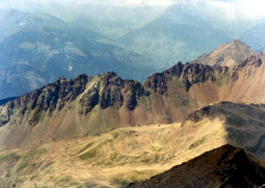
This is the group of Monte Emilius (3.559 m) with a view, winter, from the West. A small mountain range located between the well-largest Group of Gran Paradiso (4.061m) to the South (to the right in the photo) and the Central Valley of Baltea just above the City of Aosta. On the right side of this mountain we find the Punta or Pic Garin (3.451m), which is, although they always the same, another mini group in its own right. The junction between the two can be identified in the Pas du Valaisan (3.210m) and from above and namesake Mont (3.307m), large shoulder to the West of this last. In the middle of these two great pyramids we find that a little more depressed the Punta Rossa with its three Summits (Western or Top 3.401m, Central about 3.395 meters, Eastern 3.400m)), which connects the sinuous shape between them, between the Colle di Arbolle to Nord and Pas du Valaisan South. At the left edge of the pyramid we find twin of Becca di Nona (3.142m), Top very popular and frequented by the City of Aosta (550 meters about), while at the other extreme we find the tiny Subgroup of Punta della Valletta (3.090m), which dominates the entire District of Pila, renowned Ski-Resort. From this basin basically start all Excursions and Climbs to these mountains; on the opposite side, or with the Walloons Eastern des Laures, Lussert, Fleurie and Arpisson, attendance is definitely smaller and is mainly devoted to the visitation of beautiful lakes. Regarding the Mont Valaisan it constitutes more transit point that is not goal end in itself.
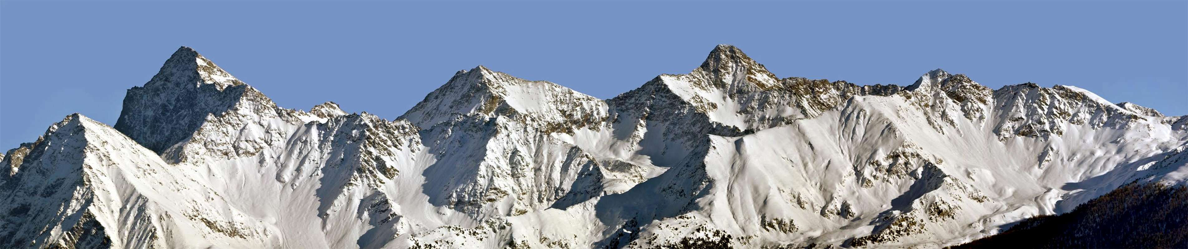
Questo é il Gruppo del Monte Emilius (3.559 m) con vista, invernale, da Occidente. Una piccola catena montuosa situata tra il ben più esteso Gruppo del Gran Paradiso (4.061 m) a Mezzogiorno (verso destra nella foto) e la Valle Centrale della Dora Baltea subito al di sopra della Città d'Aosta. Sulla destra di questa montagna troviamo la Punta o Pic Garin (3.451 m), che costituisce, pur facendo sempre parte del medesimo, un altro mini gruppo a sé stante. Il punto di congiunzione tra i due può essere individuato nel Pas du Valaisan (3.210 m) e dal soprastante ed omonimo Mont (3.307 m), grande spallone ad Ovest di quest'ultima. In mezzo a queste due grandi piramidi troviamo quella un poco più depressa della Punta Rossa con le sue tre Sommità (3.401 m, 3.395 circa, 3.400 m)), che in forma sinuosa le collega tra di loro, compresa tra il Colle di Arbolle a Nord ed il Pas du Valaisan a Sud. Al margine sinistro troviamo la piramide gemella della Becca di Nona (3.142 m), Sommità molto popolare e frequentata dalla Città di Aosta, mentre allo estremo opposto troviamo il minuscolo Sottogruppo della Punta della Valletta (3.090 m), che sovrasta lo intero Comprensorio di Pila. Da questo bacino in pratica partono tutte le Escursioni e le Ascensioni verso queste montagne; sul lato opposto, od Orientale con i Valloni des Laures, Lussert, Chaz-Fleurie ed Arpisson, la frequentazione é sicuramente minore e risulta principalmente rivolta alla visitazione di splendidi laghi. Per quanto concerne il Mont Valaisan esso costituisce più punto di transito che non meta fine a sé stessa.
We continue the search for mountains that that are not well known. Some for not being very high, others because they are often "stifled" by the mountains neighbor most important and that constitute an attractive higher. This is the case of Mont Valaisan, a pyramid, a little depressed and consists of three ridges and as many sides and that can look like a big Western Shoulder of Punta Garin (3.451m); a little like the Mont Ròss de Comboé (3.301m) towards the Monte Emilius, on its West Ridge. Even the Mont Valaisan like this, in addition to having almost similar altitude, has been recognized as a mountain in itself only in the last forty years or so, since prior were considered exclusively the hills subject vis the same: the Col Ròss (3.091m) to the first and the Pas du Valaisan (3.210m) for the second. As compared to the first case we find only a fleeting reference in the "Monthly Magazine C.A.I. in 1903" (page 116) by the Abbot Joseph Maria Henry, with regard to the Pas du Valaisan while Giovanni Bobba and Luigi Vaccarone dedicated to him in the "Guide of Western Alps Pennine Graians Vol. II. Second Part" three pages (33/5). Both have assumed dignity mountain autonomous with the publication in December 1978 of "Guide of Monte Emilius" by Osvaldo Cardellina, in which was to be given a name; later the same was accepted and taken on some Maps first local and then in "Emilius Rosa dei Banchi Parco del M.Avic" by Giulio Berutto, Lino Fornelli, Edited by C.A.I./T.C.I. in the Series "Guide to Mounts of Italy", March 2005.
Since then they have ceased to be considered only as big shoulders for to be identified as the mountains in their own right. Appropriate toponomastic recognition, supported by a precise topographical placement if anything, even more than not of mountaineering interest, for the size and the mass of which they have. Both are also important node topographic, where the ridges unfold clearly separating different valleys or walloons; in the case of Mont Valaisan fact we Vallon Arbolle to the West, that of Grauson, branch Lussert, East and that of the Arpisson in the South. The three mountain ridges clearly separate the one from the other and only the Hills of Garin (2.815m) and Pas du Valaisan (3.210m) gather, tying them in pairs, while for to transit directly from that of Arpisson that Lussert must climb over the Mont Valaisan using, via the North Ridge-northeast, reaching the Pas du Valaisan; otherwise using, by short and not difficult descent, the two small incisions (2.980, 2.990 meters about) on its Crest Southeast, before that the watershed, becoming sharper as Edge more to the North, begins to climb steeply to Peak Garin. From these you descend rapidly through two parallel snowfields, divided by a small rocky spur, on the stony ground underlying the Pas. Definitely not constitute destination in its own right, but rather the point of almost obligatory passage to climb Emilius (3.559m), Punta Rossa (3.451m) and Pic Garin, into the same small Group towards North in respect to the entire Gran Paradiso (4.061m) Mountain Chain. From the Top beautiful view to 360°, a little limited by the pyramids of Monte Emilius and three Punta Rossa towards North and Punta Garin to the East.
Continuiamo la ricerca di montagne che non siano molto conosciute. Alcune per il fatto di non esser molto elevate, altre perché spesso son "soffocate" da più vicine nonché importanti e costituenti un polo d'attrazione maggiore. Questo é il caso del Mont Valaisan, una piramide un pò depressa e formata da tre creste ed altrettanti versanti e che può apparire come uno Spallone Occidentale della Punta Garin (3.451 m); un poco come il Mont Ròss de Comboé (3.301 m) nei confronti del Monte Emilius, sulla sua Cresta Ovest. Anche il Mont Valaisan come questo, oltre ad avere quasi similare altitudine, é stato riconosciuto come montagna a sé stante solo negli ultimi quaranta anni circa, poiché in antecedenza venivan considerati esclusivamente i colli soggiacenti agli stessi: il Col Ròss (3.091 m) per il primo ed il Pas du Valaisan (3.210 m) pel secondo. Mentre nei confronti del primo caso troviamo esclusivamente un fugace accenno nella "Rivista Mensile C.A.I. 1903" (pagina 116) da parte dell'Abbé Joseph Maria Henry, per quanto concerne il Pas du Valaisan Giovanni Bobba e Luigi Vaccarone gli dedicano in Guida delle Alpi Occidentali Graie e Pennine Vol. II. Parte Seconda" ben tre pagine (33/5). Entrambi hanno assunto dignità di montagna autonoma con la pubblicazione nel Dicembre 1978 di "Guida del Monte Emilius", nella quale veniva a loro assegnato un toponimo; in seguito il medesimo veniva accettato e ripreso dapprima su alcune Carte locali e poi in "Emilius Rosa dei Banchi Parco del M.Avic" ad opera di Giulio Berutto e Lino Fornelli, Edito dal C.A.I./T.C.I. nella Collana "Guida ai Monti d'Italia" nel Marzo 2005. Da allora han smesso d'essere considerati soltanto come grandi spalle per essere individuati quali montagne a sé stanti. Un giusto riconoscimento toponomastico, suffragato da preciso collocamento topografico se non altro, più ancor che l'interesse alpinistico, per le dimensioni e per la massa delle quali esse dispongono. Inoltre entrambi costituiscono importante nodo topografico, dove le creste si sdoppiano separando nettamente diversi valloni; nel caso del Mont Vallaisan abbiamo infatti il Vallone di Arbolle ad Occidente, quello del Grauson, ramo di Lussert, ad Oriente e quello di Arpisson a Mezzogiorno. Le tre creste della montagna separano nettamente l'un dall'altro e soltanto il Colle di Garin (2.815 m) ed il Pas du Valaisan (3.210 m) li riuniscono, legando loro a due a due, mentre per transitare direttamente da quello di Arpisson a quello di Lussert si deve obbligatoriamente scavalcare il Mont Valaisan utilizzando, tramite la Cresta Nord-nordest, il Pas du Valaisan; altrimenti sfruttando due intaglietti (2.980, 2.990 metri circa) sulla sua Cresta Sudest, prima che lo apartiacque, facendosi più affilato come Spigolo più a Nord, inizi a salire decisamente alla Garin. Sicuramente non costituiscono meta a sé stante, quanto piuttosto punto di passaggio quasi obbligato per salire l'Emilius (3.559m), Punta Rossa (3.401 m) e Garin, nello stesso piccolo gruppo a Nord rispetto alla Catena del Gran Paradiso. Dalla Cima splendida vista a 360°, un po' limitata dalle piramidi dell'Emilius verso Nord e dalla Garin ad Oriente.
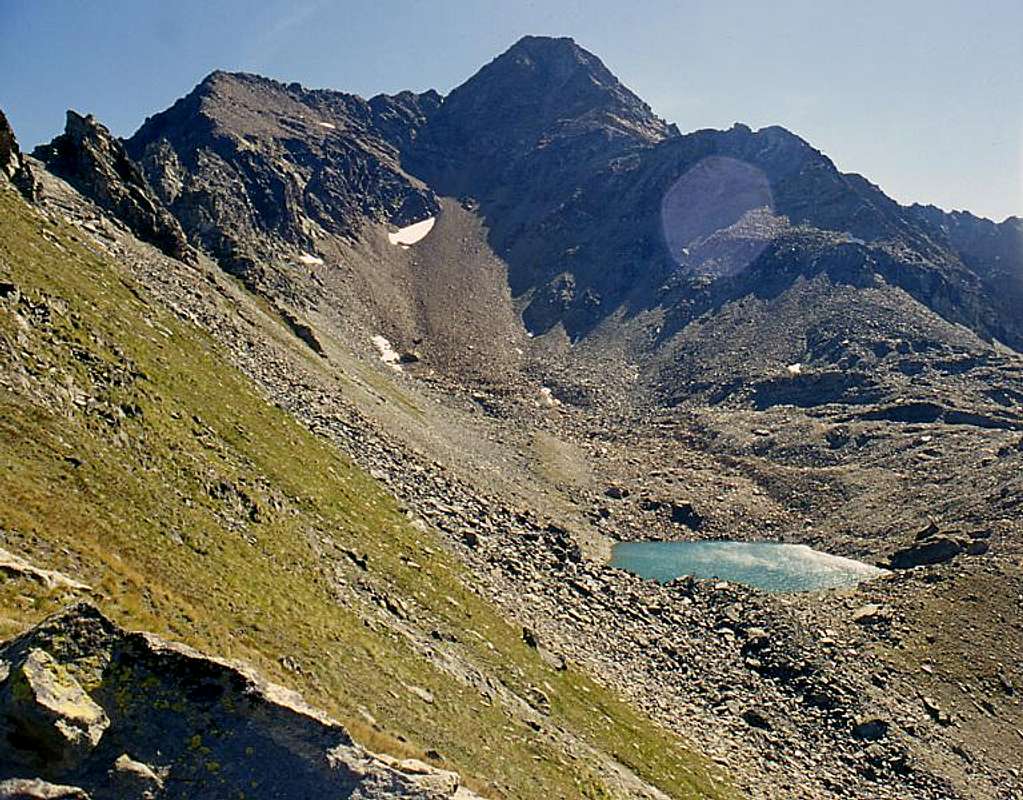
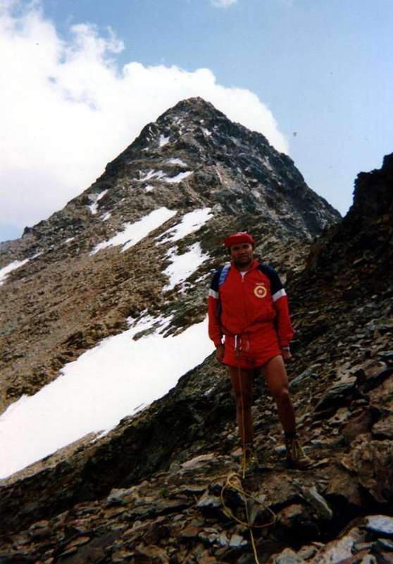
This mountain is sited between Western Punta Rossa (3.401m) and Pic Garin (3.451m), both in Emilius Group. Indeed that of Garin can be considered a Sub-group a little autonomous, the limits of which can be identified precisely the Pas du Valaisan in the North and Garin Hill in the Southwest at the end of the ridge that descends from Mont Valaisan; to the South-southwest extends a long buttress that ends with the Tsaplana (2.681m) above the Village Gimillan in Cogne Valley, while to the East "projecting" a jagged ridge that ends abruptly with the Tour Grauson (3.240m). The Mont Valaisan is triangular pyramid which has three ridges and as many faces: a long Ridge Southwest is addressed to Garin Hill (2.815m) before it rises to the crest of Punta Pian Bessey (3.085m), dividing the Vallons Arpisson Arbolle; another short North-northeast Crest falls Pas du Valaisan, separating the latter from that of Grauson, upper branch of Lussert. A third and final revolt in the Southeast Mont Valaisan tie to Peak Garin, ending indented to a carving, before the partition turn into a corner well steeper leading to the Summit of the pyramid higher. Of the three only the last two are popular, because they pass through the same also Normal Routes for Punta Garin, from Slopes Lussert and Arpisson, while the third rising from Col Garin is traversed only once in summer 1940 by Toni Ortelli and Nando Quagliolo. Regarding the faces speech is quite similar: same considerations for the Northeast aimed at Lussert Lakes and Lake Garin the Southwest; Northwest to drive down a high and steep wall of over 300 meters, which falls on the tawny moraines, remains of the ancient Glacier Mount Emilius. Even a sole ascent one time in 2004, it is quite difficult, but especially dangerous for the bad quality of the rock and the considerable material in the balance, it is very exposed to falling rocks and therefore totally inadvisable.
 |
Questa montagna é situata tra la Sommità Occidentale della Punta Rossa (3.401 m) e la Punta Garin (3.451 m), entrambe nel Gruppo dell'Emilius. Anzi quello della Garin può essere considerato un Sottogruppo un poco autonomo i limiti del quale sono individuabili proprio al Pas du Valaisan a Settentrione ed al Col Garin a Sudovest al termine della cresta che scende dal Mont Valaisan. Verso Sud-sudovest si prolunga un lungo contrafforte terminante con la Tsaplana (2.681 m) sopra al Villaggio di Gimillan in Val di Cogne, mentre ad Oriente "proietta" una cresta frastagliata che si interrompe bruscamente con la Tour Grauson (3.240 m). Il Mont Valaisan risulta quale piramide triangolare che presenta tre creste ed altrettanti versanti: una lunga Cresta Sudovest si indirizza al Col Garin (2.815 m) prima che la cresta spartiacque si rialzi alla Punta di Pian Bessey (3.085 m), dividendo i Valloni di Arpisson ed Arbolle; un'altra breve Cresta Nord-nordest scende al Pas du Valaisan, separando quest'ultimo da quello del Grauson, ramo superiore del Lussert. Una terza ed ultima rivolta a Sudest lega il Mont Valaisan alla Punta Garin, terminando frastagliata ad un intaglio, prima che il divisorio si tramuti in uno spigolo roccioso ben più ripido conducente alla Sommità della piramide più elevata. Delle tre solo l'ultime due son frequentate, poiché tramite le stesse passano anche le Vie Normali per la Punta Garin dai Versanti Lussert ed Arpisson, mentre la terza, che sale dal Col Garin, risulta percorsa un'unica volta nell'estate 1940 da Toni Ortelli e Nando Quagliolo. Per quanto concerne i versanti il discorso é abbastanza similare: stesse considerazioni per quello Nordest rivolto ai Laghi di Lussert ed al Lago Garin il Sudovest; a Nordovest scende invece un'alta e ripida parete di oltre 300 metri, che precipita sulle fulve morene, resto dell'antico Ghiacciaio dell'Emilius. Anch'essa salita una sola volta nel 2004, risulta abbastanza difficile, ma soprattutto pericolosa per la pessima qualità della roccia ed il notevole materiale in bilico, quindi molto esposta alla caduta di pietre e pertanto del tutto sconsigliabile.
![]()
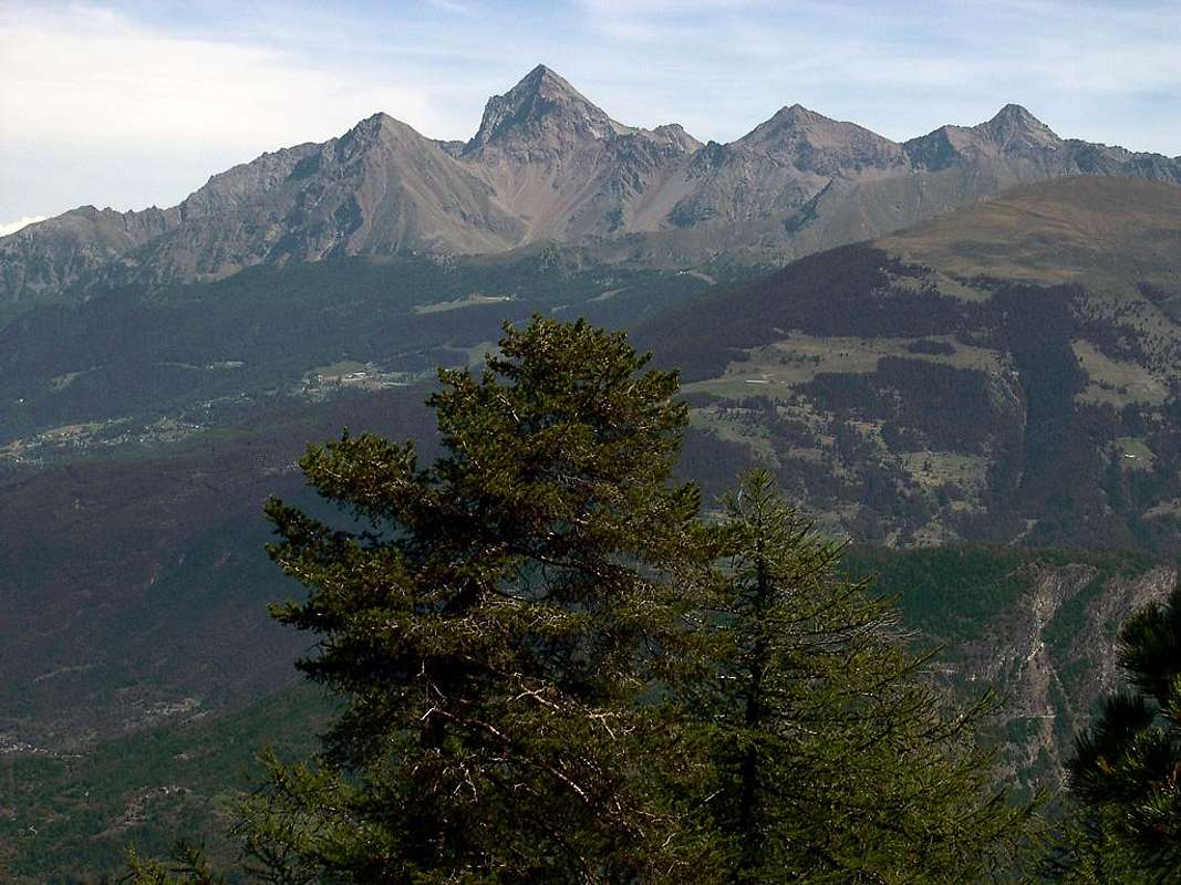
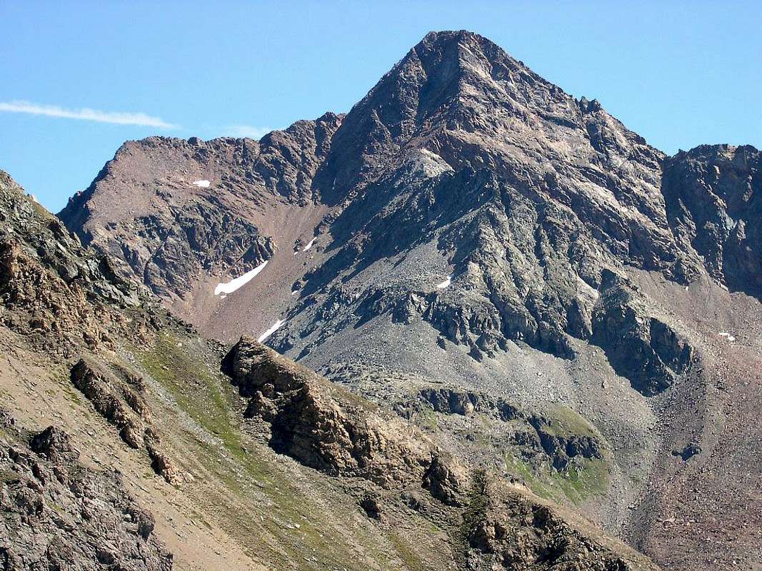
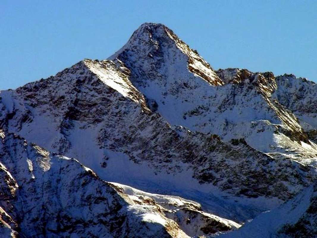
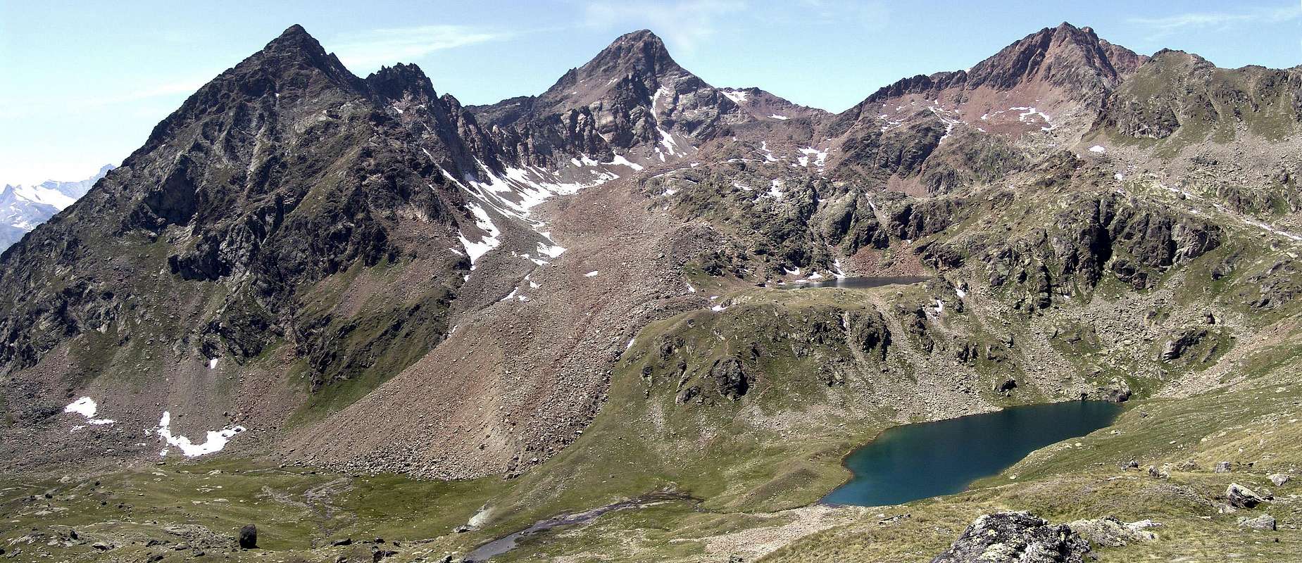
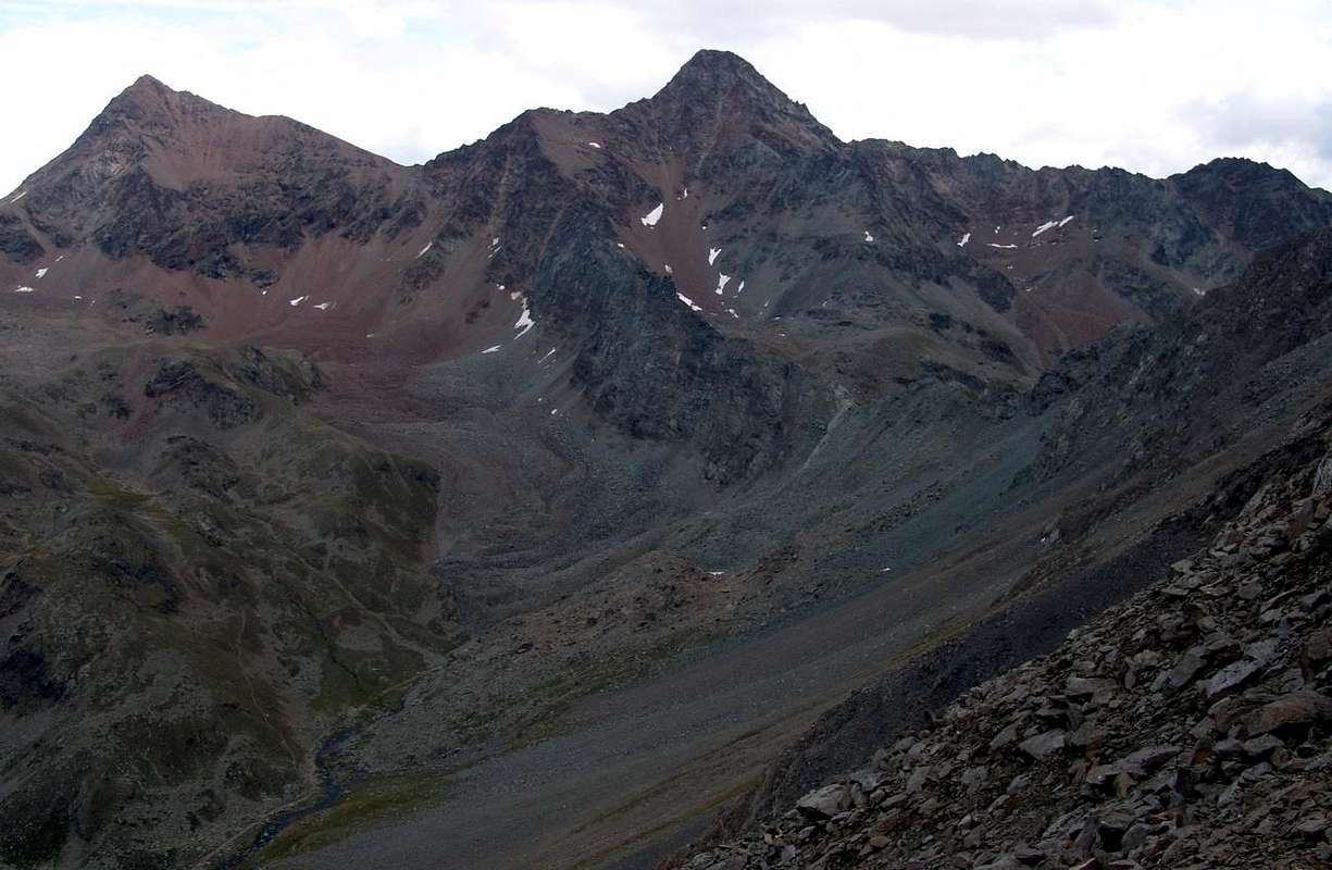
Left: three Punta Rossa, Pic Garin & Mont Valaisan from Emilius, by Osw
![]()
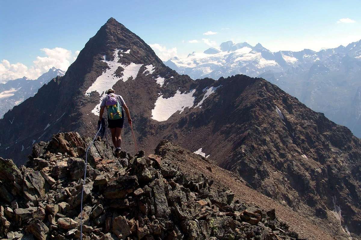
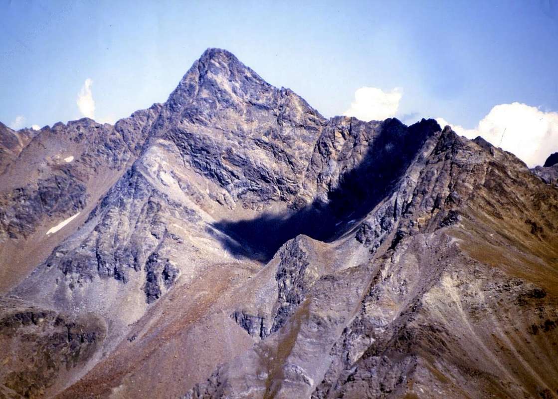
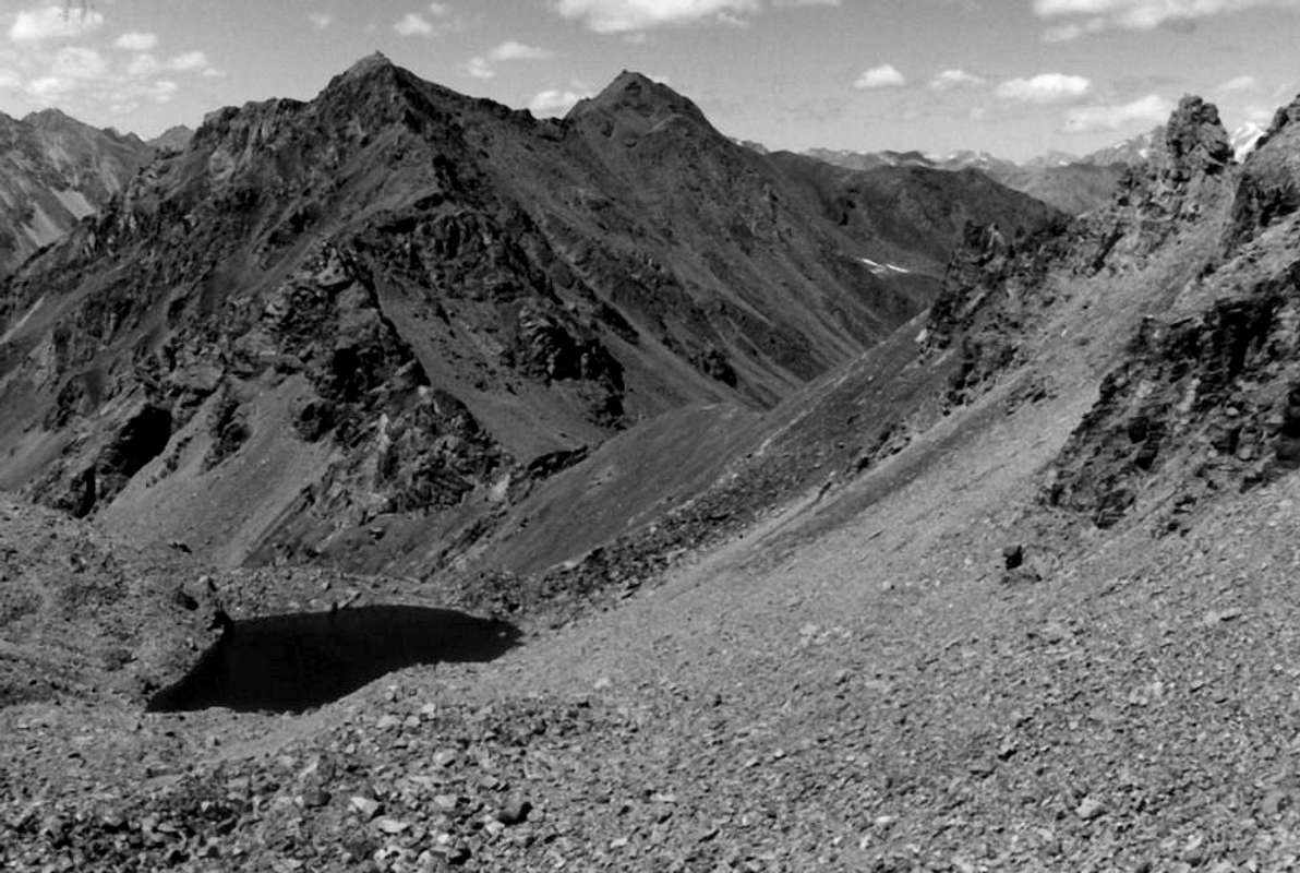
Pic Garin & Mont Valaisan (shadowed) from Emilius Summit, by emilius
![]()
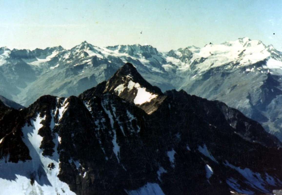
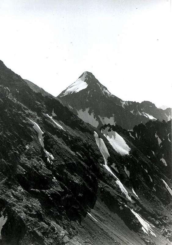
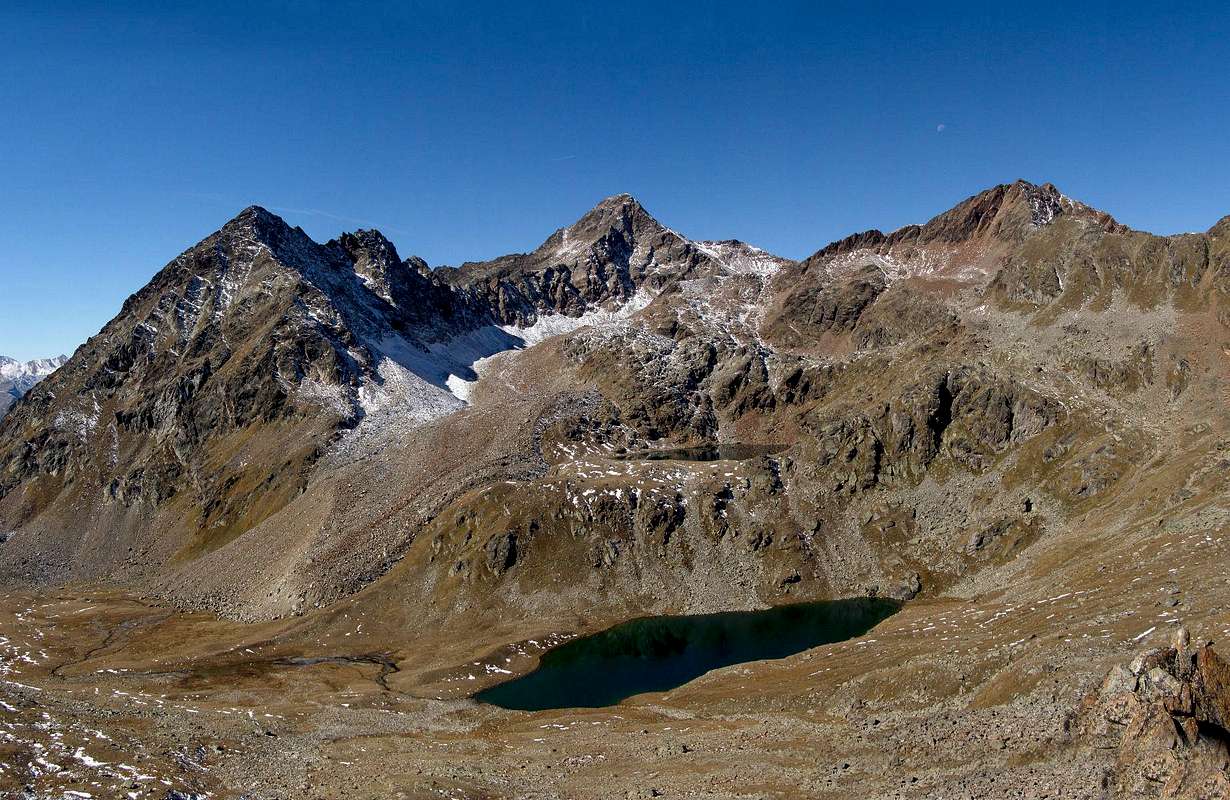
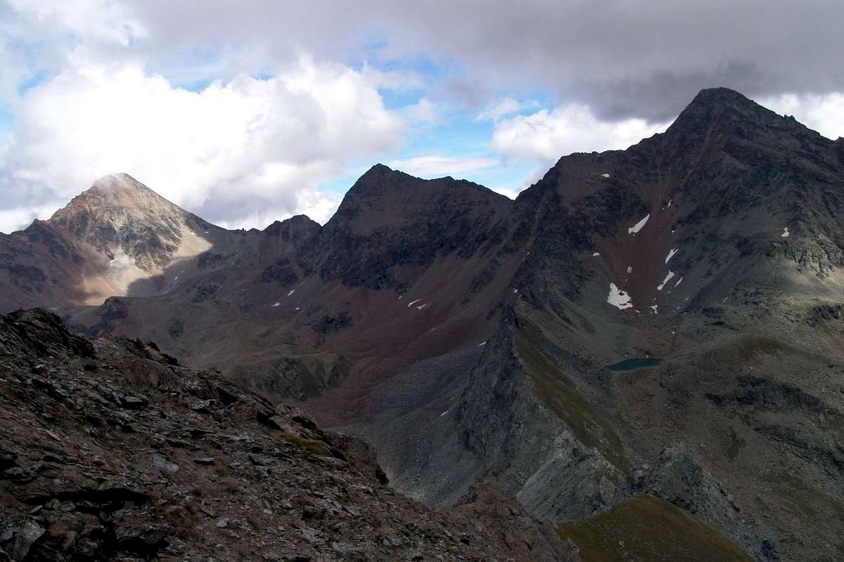
Pic Garin & Mont Valaisan at the end of Autumn, by Antonio
![]()
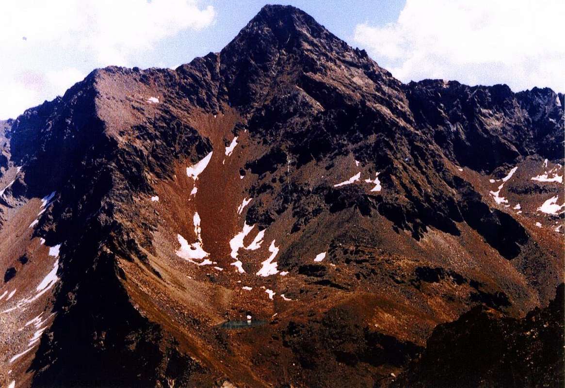
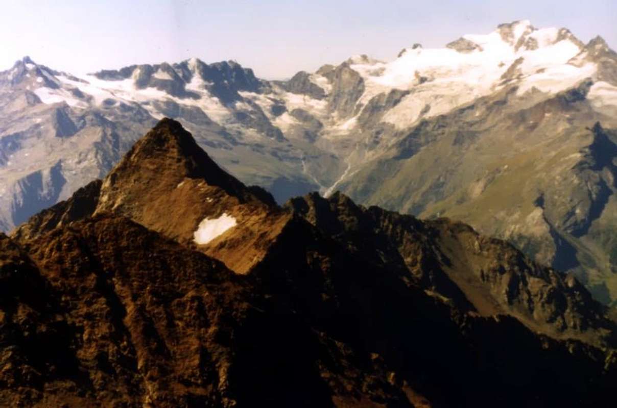
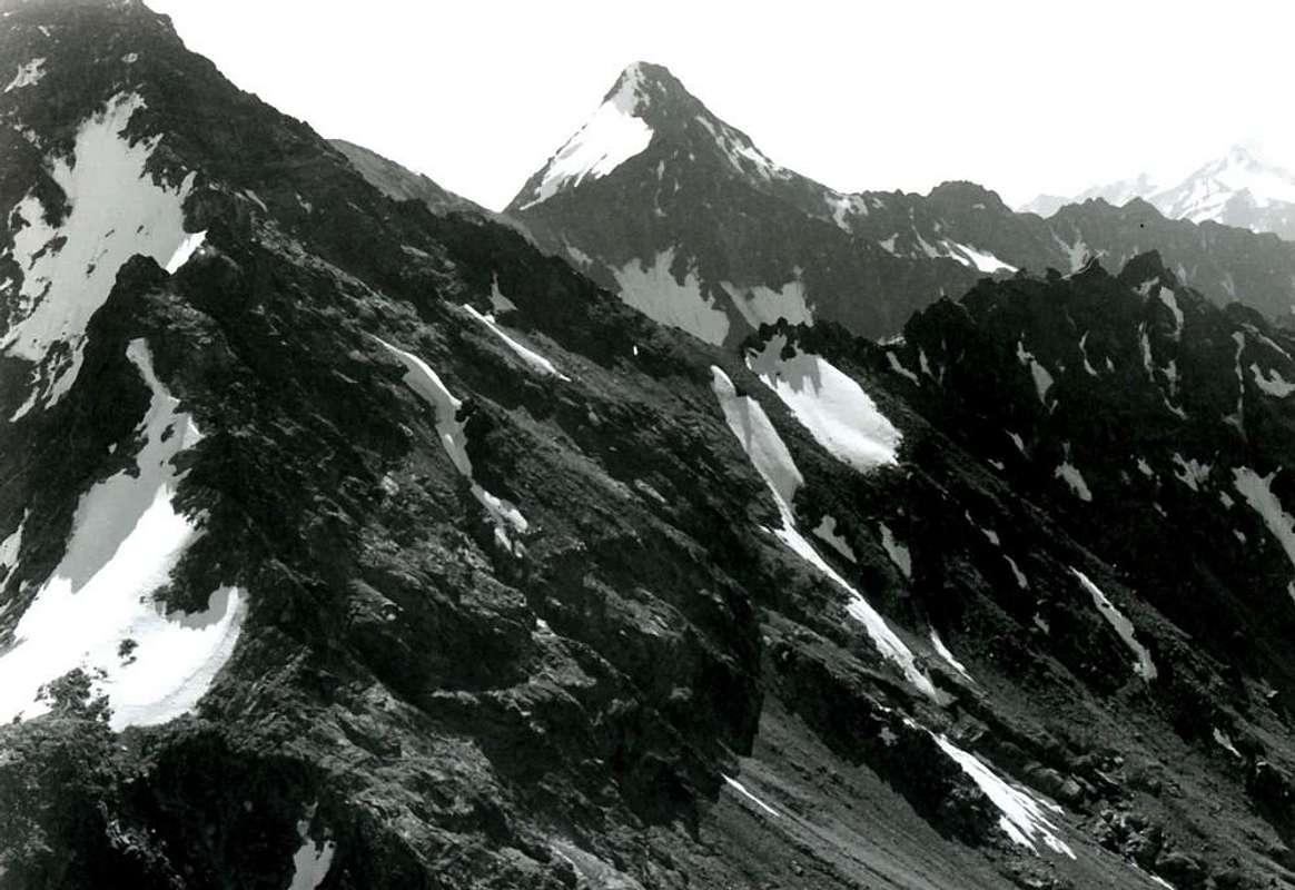
Pic Garin behind the pyramid depressed of Mont Valaisan, by Osw
![]()
![]()
Ascending on Garin Hill from Arbolle Vallon, by Gino Bolfo
SW Ridge above Garin Hill, between Arbolle & Arpisson, by emilius
![]()
From Garin Hill towards the Lake & SW Face, by Gino Bolfo
![]()
Arpisson Vallon from Punta Pousset or S-SW, by emilius
![]()
Pas du Valaisan over Grauson-Lussert Vallon, by Marco Cossard
![]()
Valaisan above Lussert four Lakes in Grauson Vallon, by pr18
![]()
Mont Valaisan between Pic Garin & Punta Rossa in Grauson Vallon branch of Lussert, by emilius
![]()
Arbolle: N Crest (left, from Valaisan Pass), NW Wall, W-NW Ridge above Garin Hill, by emilius
![]()
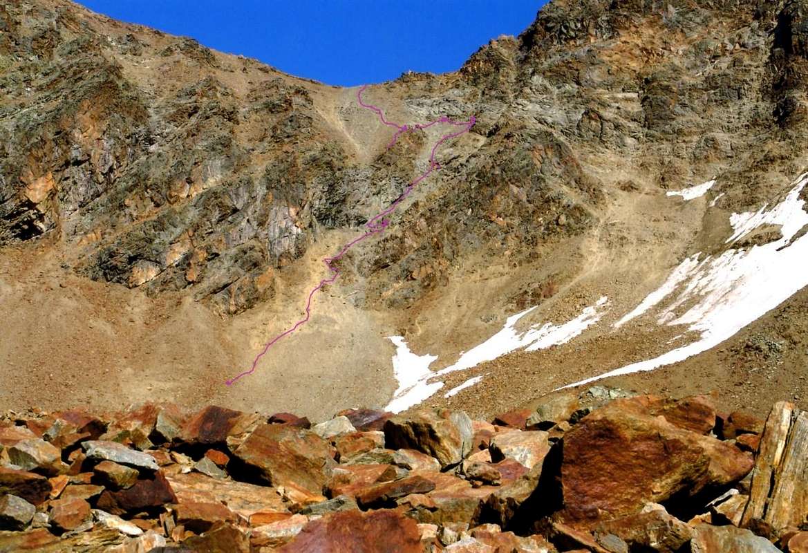
From Garin Lake (2.854m) ascending on Southwest Face, by emilius
![]()
From Arbolle or Arpisson (right): NW Wall, W-NW Ridge (center) and SW Face, by emilius
![]()
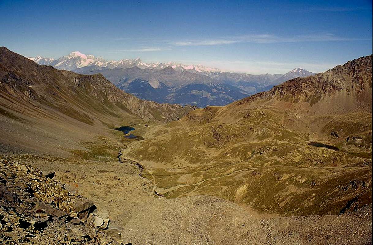
Pas du Valaisan (3.210m) by Western Slope or Arbolle, by emilius
![]()
Arriving from Peak Garin (left), by Osw
![]()
Mont Valaisan (in bottom) from Peak Garin, by Osw
HISTORICAL NOTE & TOPONYMY
HISTORICAL REMARK & TOPONYMY: to attribute the first ascent of this mountain is not something simple and even easy. Too much time has elapsed since the early steps, certainly not addressed here, but the most important pyramid Pic Garin; we try to do this using the method of logic. The first ascent of Garin takes place in 1856 by the Abbots Balthazar Chamonin and Pierre Chanoux, but you do not know anything exclusively the sole starting point: the Town of Aosta. Logic says that if they had chosen the ridge-edge West-northwest (likely) given the length of the approach with over 3.000 meters of altitude to climb in the day, they would not lose more time in doing this digression towards left that leads to Summit of Mount Valaisan. The second information is found in "L'Alpinista 1875, 9" before the official magazine of the C.A.I., where on page 152 is given news of a climb to the first crossing with Garin "for new way" by the Official Alpine Troops Cesare Pavese with two soldiers, August 9th, 1875. the deduction is that either the Pavese was not aware of the trail in 1856, or the first have made another route. We are inclined, since the term crossing, a climb to the Col Garin for the South-southwest Slope and end on Northern Edge with the same relative descent, but through the Pas du Valaisan, always towards the Walloon Arbolle or Arbole as it was called then. If so, would surely climbed the Mont Valaisan and therefore they are the first climbers. Surely fù reached in 1894 by the English group a rope climbers led by the very famous Guide Swiss Alexander Burgener, always downhill from Pic Garin after having completed the first ascent of the Southwest Ridge then still a virgin, as "C.A.I. Magazine 1895", p. 183. With regard to the place names, in addition to the above, there is an old name of Bec de l'Eco according to a toponomastic study published by Piero Falchetti, while both I.G.M. (Italian Military Geographical Institute) that other Maps show the altitude with no name. The observation, surely the result of information on the spot, may be plausible, given that in the front Western Side of the Arbolle under the Trident de Comboé exists a Lake of the Goats also called Lac de l'Echo and so appears in the paper "Hapax 2008". in fact from this point the mountain responds with a big echo, the result of a sounding board formed in foreground by the Northwest Wall.
NOTA STORICA TOPONOMASTICA: attribuire la prima ascensione di questa montagna non risulta cosa né semplice e neppur facile. Troppo tempo é trascorso dai primi passaggi, certamente non qui indirizzati, bensì alla più importante piramide del Pic Garin; proviamo a fare ciò utilizzando il metodo logico-razionale. La prima salita della Garin avviene nel 1856 da parte degli Abati Pierre Chanoux e Balthazar Chamonin, ma non si conosce nulla se non il punto di partenza: la Città d'Aosta. La logica dice che se avessero scelto la cresta-Spigolo Ovest-nordovest (probabile) non avrebbero, vista la lunghezza dell'approccio con oltre 3.000 metri di dislivello da superare in giornata, perso ulteriore tempo nel compiere questa divagazione sulla sinistra che conduce alla Sommità del Mont Valaisan. La seconda informazione la troviamo nell'"L'Alpinista 1875, 9", prima rivista ufficiale del C.A.I., dove alla pagina 152 viene data notizia di una ascensione alla Garin con prima traversata "per via nuova" da parte dell'Ufficiale delle Truppe Alpine Cesare Pavese con due soldati, il 9 Agosto 1875. La deduzione é che o il Pavese non era a conoscenza del percorso del 1856, oppure i primi avavano effettuato altro itinerario. Noi propendiamo, visto il termine traversata, per una salita dal Col Garin per il Versante Sud-sudovest e lo Spigolo finale Nord con relativa identica discesa, ma, raggiunto il Mont, attraverso il Pas du Valaisan, sempre verso il Vallone di Arbolle o Arbole com'era chiamato allora. Se così fosse, avrebbero sicuramente scavalcato il Mont Valaisan e quindi son loro i primi salitori. Sicuramente fù raggiunto nel 1894 dalla cordata inglese guidata dalla celeberrima Guida svizzera Alexander Burgener, sempre in discesa dal Pic Garin dopo aver compiuto la prima ascensione della Cresta Sudovest allora ancor vergine, come da "Rivista C.A.I. 1895", pag. 183. Per quanto concerne la toponomastica, in aggiunta a quanto sopra esposto, esiste una vecchia denominazione di Bec de l'Eco secondo uno studio toponomastico non pubblicato di Piero Falchetti, mentre sia I.G.M. (Istituto Geografico Militare Italiano) che altre Carte riportano l'altitudine senza nome alcuno. L'osservazione, sicuramente frutto di informazioni in loco, può essere plausibile, visto che frontalmente nel lato Occidentale del Vallone d'Arbolle e sotto il Trident de Comboé esiste il Lago delle Capre detto anche Lac de l'Echo e così appare nella carta "Hapax" del 2008. In effetti da questo punto la montagna risponde con un grande eco, frutto della cassa di risonanza formata dalla Parete Nordovest.
First Ascents
- First on the Summit (probably): Officer Alpine Troops Cesare Pavese with two soldiers; Aug 13th, 1875, in ascent by Garin Lake and traverse on North Edge.
- First on the Summit (surely): F.W. Oliver, C. Baker and C. Hiatt with Swiss Mountain Guide Alexander Burgener; Sep 01th, 1894, in descent by North Edge of Pic Garin and crossing through Southeast Crest and North-northeast Ridge towards Valaisan Pass, after the crossing of Fleurie Pass and Southwest Crest of Pic Garin.
- In winter: Unknown.
- Southeast Crest: the rope 1875 in partial ascent with crossing towards the Pic Garin; the climbers 1894 completely in descent from Garin with traverse to Mont Valaisan.
- South-southwest Slope: Officer of the "Alpini" Cesare Pavese with two soldiers; Aug 13th, 1875, in ascent by Garin Lake towards Southeast Crest and Northern Edge.
- Southwest Face (directly): Osvaldo Cardellina, Marco Cossard and Giuseppe Lamazzi; Jun 29th, 1976, from Garin Hill, Lake with direct climbing on rocky triangular wall.
- Southwest Ridge: Toni Ortelli and Nando Quagliolo; probably in summer 1940, in ascent from Pila through the Arbolle Walloon, Garin Hill with almost integral via.
- Northwest Wall: Osvaldo Cardellina, lone; Sep 12th, 2004, in ascent from Arbolle Walloon and following traverse to three Punta Rossa up to the Monte Emilius.
- North-northeast Crest (Valaisan Pass): the rope 1875 more probably in descent; surely a group of roped climbers of 1894 in descent. Agostino Ferrari with Mountain Carrier B. Glarey; Sep 14th, 1898, in the first crossing from Punta Rossa to Pic Garin; Anselme Falcoz; Aug 1936, in first traverse from Pic Garin up to the Monte Emilius.
- East-northeast Face (directly): Osvaldo Cardellina, Danilo Garzotto and Natalino Massoni; Aug 16th, 1993, in descent from Pic Garin and crossing to three Punta Rossa.
- Great traverse South/North (Mont Valaisan, Pic Garin, Mont Valaisan, three Punta Rossa, Arbolle Hill, Punta dei Cappuccini and Three Capuchins Pass, Monte Emilius): Osvaldo Cardellina, Marco Cossard and Giuseppe Lamazzi; Jun 29th, 1976, in ascent from Pila, Garin Hill and North-northwest Ridge of Pic Garin and subsequent traverse.
- Great traverse South/West/South (Punta des Laures by South Spur, three Punta Rossa (Eastern, Central and Western), Pas du Valaisan and Mont, Pic Garin): Osvaldo Cardellina and Camillo Roberto Ferronato; Jul 25th, 1976, in ascent from Gimillan, Grauson-Lussert Walloon with descent, by East-southeast Crest, on Chaz-Fleurie.
Getting There
BY CAR:
- From TORINO, MILANO, etc: Motorway A5. Exit at IVREA or Quincinetto (PIEDMONT).
- From IVREA Town: in West (Southern side) towards Charvensod, Gressan, Jovençan, Aymavilles Municipalities.
- From Charvensod to Dard-Comboé-Arbolle Vallons towards Ponteilles (1.697m) Alp/Waterfall, through dirt road, Comboé Alp/Saint Ours Shelter (2.114m), through dirt road, and Arbolle Refuge (2.516m), near Lakes (2.497m), by Chair Lift to Chamolé Station (2.309m), Lake (2.325m) and muletrack. From Charvensod (main road from Pont Suaz 567m) or from Gressan (603m; alternative road) to Tivet, Les Fleurs Hamlets (1.292m, 1.414m) Pila Basin and Pila Resort (1.800m); upper parking 1.850m). Arno Shelter (2.660m), always open but unguarded, nearby Couiss Summit on watershed Pila/Cogne Valley. From Jovençan (631m) to Pila Conca, exclusively through path-muletrack to Tourlin Dessous (1.466m) and by dirt road to Pila-Posse Tennis (1.776m). From Aymavilles (646m) to Western Pila Conca, through Main Road to Cogne Valley, alternative to Ozein/Turlin Dessus Hamlets and dirt road to Pila-Posse. From Aymavilles Municipality (646m) towards Cogne Valley with Main Road towards Cordolomé Pasture (1.064m), Vieyes (1.158m; ancient small Sainct Grat Church with various frescoes) Fraction; continue to Silvenoire Village (1.331m), Laval Bridge (1.364m) Epinel (1.436m) and Crétaz (1.494m) Hamlets, Cogne (1.534m) Resort, through Main Road. In North towards Gimillan Village (1.778/85m) with Regional Road and from this to Franco Nebbia Bivouac (2.740m), with path in Upper Arpisson Vallon.It is not necessary to take Motorway A5: you can drive on SS.26, in the direction of AOSTA - IVREA - TURIN.
BY PLANE:
- Aeroporto "Corrado Gex" Saint Christophe (Aosta).
Approaches
Approach A from Pila Resort: From Pila (around 1.800/50 meters) famous ski Resort and very popular in the last decade for competitions including international mountain bike downhill specialties, easy and fastly reachable from Aosta Town using car, bus or cableway, get the Chamolé Lake (2.325m) on foot through the various paths n° 19/19A/19B, passing respectively to the Alpage of Chamolé (2.532m; fountain), also towards the Bois (Wood) Chanté, going up directly into a small vallon to Chamolé Lake (2.325m). Or by a chairlift to Upper Station (2.311m), and the homonymous hill above (2.641m) Arbolle Walloon with the new shelter. The refuge near the Lake with the same name (2.516m), is even reachable from the Cogne Valley starting from Gimillan Hamlet (1.787m) through the Walloon of Arpisson, the Bivouac Franco Nebbia and the Garin Hill (2.815m), through the trails n° 2 and down in Arbolle Walloon, through n° 18) ford the torrent in a small cove at the old barn and started to go up with large bends between grassy slopes through the path n° 18/TVC.
Avvicinamento A dal Comprensorio di Pila: Da Pila (circa 1.800/50 metri), nota località sciistica e turistica e nell'ultimo decennio alquanto frequentata per gare anche internazionali di mountain bike specialità downhill; la medesima risulta raggiungibile abbastanza rapidamente da Aosta in auto pullman o funivia, pervenire al Lago di Chamolé (2.325 m, anche qui in seggiovia o a piedi fino alla Stazione Superiore (2.311 m) tramite i vari sentieri n° 19/19A/19B), che passano rispettivamente per l'Alpe di Chamolé (2.532 m; fontana). Altrimenti attraverso il Bois Chanté, salendo direttamente tramite un valloncello appena ad Oriente al Lago di Chamolé (2.325 m) e l'omonimo colle superiore (2.641 m) per poi rapidamente discendere al Rifugio di Arbolle. Il nuovo rifugio (2.516 m), é raggiungibile anche con collegamento dalla Valle di Cogne con partenza dal Villaggio di Gimillan (1.787 m) tramite il Vallone di Arpisson con l'omonimo alpeggio, il Bivacco Franco Nebbia (2.740 m) ed il Colle Garin (2.815 m) con i sentieri n° 2 ed in abbastanza breve discesa nel Vallone di Arbolle con il sentiero n° 18.
Approach B from the Walloon of Comboé: by Comboé (2.114m; private retreat of the Canons of Saint Orso) reachable by the below Ponteilles Alpage (1.697m; beautiful waterfall) through the path n° 14 or from Pila via the Plan Fenêtre Hill (2.229m), through the path n° 16, you can reach the Chamolé Upper Chair lift Station, and homonyms Lake and Hill with two other possibilities:
1) - immediately behind the shelter apart from the steep path n° 19 rather than through hairpin bends to reach the North Col Replan (2.366m); from this a wider path down to the Southwest to Lake Chamolé (yellow signs) where you reconnect with the previous Approach A.
2) - it is also possible to reach the refuge with a larger circle to the South along the Comboé tableland that, after reaching the Alp derelict Grand Plan (2.158m), crosses the Torrent Comboé with a diagonal from right to left in the middle of a heap of stones; the route n° 16 at this point enters a very narrow gorge with very tight bends reaches him, hence the Approach A (calculated both from 1h'00 to 1h'15 to the refuge).
Avvicinamento B dal Vallone di Comboé: da Comboé (2.114 m; rifugio privato dei Canonici di Sant'Orso) raggiungibile dal sottostante Alpeggio di Ponteilles (1.697 m; bella cascata) tramite il sentiero n° 14; oppure da Pila tramite l'Alpe di Chamolé ed il Colle Plan Fenêtre (2.229 m), per mezzo del sentiero n° 16. Inoltre si può pervenire alla Stazione Superiore della Seggiovia, Lago e Colle di Chamolé con due altre possibilità:
1) - da subito dietro il rifugio parte il ripido sentiero n° 19 che, tramite alquanto stretti tornantini, raggiunge il Colle Settentrionale di Replan (2.366 m). Da questo un sentiero più largo scende, per mezzo di un lungo diagonale alla base Occidentale dello spartiacque, a Sudovest verso il Lago di Chamolé (indicazioni in giallo) dove ci si riconnette col precedente Avvicinamento A.
2) - Inoltre é possibile raggiungere il Rifugio d'Arbolle con un giro più largo verso Sud che lungo il pianoro del Comboé, dopo aver raggiunto l'antica Alpe diroccata di Grand Plan (2.158 m), attraversa il Torrent de Comboé con un diagonale da destra verso sinistra in mezzo ad una estesa pietraia; qui il sentiero n° 16 entra in una strettissima gola e con tornanti altrettanto ristretti raggiunge il Vallone dell'Arbolle, donde all'Avvicinamento A (1h'00/1h'15 al rifugio).
 |
Approach C from the Walloon of Arpisson (by Epinel or Gimillan Hamlets): the Garin Hill can also be reached from Cogne Valley crossing in his entirety the Arpisson Walloon, with departure from the Fraction of Epinel (1.452m) or, preferably, reaching the Pastures of the Arpisson (2.328m; spring) after a long crossroad from the Village of Gimillan (1.787m), through the path n° 3/TVC. From these, to climb the entire walloon through a good path that crosses it in his mean and, left to the left the deviation for the Hill of Tsa Setze, to reach an ample tableland known as Pian Bessey (Tableland; source), having to the shoulders for the whole slope the spectacular perspective of the Grivola. Before reaching the steep slant, that with narrow small hairpin bends reaches the pass, to continue to the right on a small trace reaching the Bivouac Nebbia (2.740m; just above the same a path brings shortly time, supporting himself in a small debris walloon, as soon as more on the right or East, to the Western bank of the Lake Garin). From the bivouac the path bending in the Northwest rooms eighty metres with very narrow hairpin bends to the pass (E; 2h'45/3h'15 from Gimillan Hamlet; 4h'00/4h'30 from Epinel Fraction). From this last Village (1.430m), just before Cogne, you can reach the Arpisson Alpage with trail n° 2, which crossed the torrent to the Northeast of the same name, first reach the Alpe di Teuvre (1.792m) and then changing the direction in Northwest, to Tsavanis Pasture (1.859m, where comes the path n° 3A, starting from Gimillan). The last stretch more to the North, crossed again the torrent to the Alp Arpisson (E; 2h'15/2h'45).
Avvicinamento C dal Vallone di Arpisson (partendo dalle Frazioni di Epinel o di Gimillan): Il Colle Garin può esser raggiunto anche dalla Valle Cogne percorrendo nella sua interezza il Vallone dell'Arpisson con partenza dalla Frazione di Epinel (1.452 m); oppure, preferibilmente, raggiungendo gli Alpeggi dell'Arpisson (2.328 m; sorgente) dopo una lunga traversata da Sudest a Nordovest con partenza dal Villaggio di Gimillan (1.787 m), tramite il sentiero n° 3/TVC. Da questi, salire il vallone per mezzo d'un buon sentiero che lo percorre nel suo mezzo e, lasciata a sinistra la deviazione per il Colle di Tsa Setze sotto il Colle e la Punta della Valletta, raggiungere un ampio pianoro-altipiano a mediamente 2.500 metri, noto come Pian di Bessey, avendo alle spalle per tutta la salita la prospettiva spettacolosa della Grivola. Prima di raggiungere il più ripido pendio, che con stretti tornantini raggiunge il colle, proseguire su d'una piccola traccia più a destra raggiungendo il Bivacco Franco Nebbia (2.740 m; acqua subito sopra a Nordest). Sopra lo stesso un sentierino porta in breve tempo, appoggiandosi in un valloncello detritico, appena più sulla destra od Est, alla sponda Occidentale del Lago Garin. Dal bivacco il sentiero piegando a Nordovest sale per un'ottantina di metri con stretti tornantini raggiungendo il Colle Garin (E; 2h'45/3h'15 dal Villaggio di Gimillan; 4h'00/4h'30 dalla Frazione di Epinel). Dalla frazione (1.430 m) si può raggiungere l'Alpe di Arpisson con il sentiero n° 2 che, attraversato verso Nordest l'omonimo torrente, raggiunge dapprima l'Alpe di Teuvre (1.792 m) e poi, cambiando la direzione in Nordovest, quella di Tsavanis (1.859 m; dove arriva anche il sentiero n° 3A partendo da Gimillan). Un ultimo tratto più a Nord, guadato nuovamente il torrente, raggiunge l'Alpe di Arpisson (E; 2h'15/2h'45).
Approach D Through Grauson Vallon Lussert branch (with departure Gimillan Hamlet): Gimillan (1.787m) go right starting from the car park of Gimillan: after few meters the indications for Lussert Lakes, St. Marcel Pass, etc. are found. The pathway is indicated by the yellow circle and strips marked on stones along the route. The path begins going immediately uphill, then the slope decreases as we go beyond a little Chapel dedicated to the Madonna (1.836m). Soon the path resumes to go up and splits in two (wooden and yellow panel signage), before it begins to penetrate into the Grauson Vallon: it's possible to continue following the right, through a long diagonal crossing high above the Torrent Gru, one that goes down as far as the Ecloseur Bridge (1.904m), but in such a case we must go up again with the diagonal crossing of the subsequent grassy slopes; it's better to follow the left one that, in practice without losing height, arrives at the bridge under the Pila Alpage (2.025m), cross it and, following the stepped pathway, overcome the rocky bastion beside a fine waterfall (in plain sight to the left). At this point the path turns right markedly, entering, high on the torrent, into a small walloon; by an alternation of steep and slight slopes, it reaches, after the Créuzet Alp (2.244m; private and always closed) a panoramic cross (2.296m), on the edge of a pleasant plateau (superb view of the far La Grivola!). The path continues with slight descent through the meadows; after the Old Grauson Pastures (2.273m), crosses the Money and Grauson Torrents on the Pikaciù Bridge (2.298m) and by a steep trail beside the second, reach the wide upper part of the Grauson/Doreire Vallon. At the junction before Pralognan Pasture (about 2.400m), instead of going straight ahead along the pathway n° 4 leading to the head of Grauson, branch Lussert, Vallon, go left till to Alp Grauson Nuove (2.540m), where once there was the burned Tentori Bivouac. Continue, after crossing the intersection of the two Torrents of Tsesère and Lussert, along grassy slopes into an area of blocks toward the Lower Lussert Loch (2.713m), then after passing a prominence, to the Lago Medio (2.800m) and to the Lago Superiore (2.906m); herefrom, following toward South the torrent, remount almost fastly towards a fourty small lake (2.926m), almost always iced and secluded from the route that leads North to the Laures Hill (3.305/6m). Faithfully following toward West through steep moraine, across a small gorge and passing over the South spur of Punta des Laures at about 3.100m, you can get the small basin under the Pas du Valaisan, easily accessible along debris with some small track formed by a few years, as a signal of a return in "vogue". The following Northeast Crest is easy and requires some workarounds on Eastern side in its more rugged-rocky last part; the same is formed by sharp rocks alternate with some small carvings that fall toward the Nortwest Wall (EE; 0h'45/1h'00 Pas du Valaisan; 3h'45/4h'15 Grauson Nuove; 6h'00/6h'30 Gimillan).
Important advicei for the ascent and descent: The North-northeast Crest is to be avoided from Arbolle Walloon, the access to Pas du Valaisan is very steep and dangerous for stone falls. On the contrary the access from Grauson/Lussert Walloon is very simple, easy and safe. Best way to go down is toward Grauson, Lussert branch, always along the North-northeast Crest, with opposite route or Southwestern Face towards the nearby Garin Lake, Hill and the new Franco Nebbia Bivouac (2.854m, 2.815m, 2.740m).

Avvicinamento D dal Vallone del Grauson ramo di Lussert (partendo dalla Frazioni di Gimillan): dal parcheggio nel centro del villaggio (1.787 m) andare a destra incontrando dopo pochi metri le indicazioni per i Laghi Lussert Laghi e Colle di Saint Marcel o Corona. Il percorso è cerchiato in giallo o da strisce sempre con lo stesso colore segnate sulle pietre lungo il percorso. Lo stesso inizia andando subito ripidamente in salita, poi la pendenza cala, appena oltrepassata una Cappelletta dedicata alla Madonna (1.836 m), posta tra le rovine dell'Alpe Raventì ed il Ponte dell'Ecloseur. Ben presto il sentiero riprende a salire dividendosi in due (pannello segnaletico in giallo), prima che cominci a penetrare nel Vallone del Grauson vero e proprio: è possibile continuare a seguire il più comune, tramite un lungo diagonale con traversata alta sopra il Torrent Gru, discendente fino al Ponte Ecloseur (1.904 m), tal poi da richieder una risalita con l'attraversamento in diagonale dei successivi pendii prativi; meglio seguire quello di sinistra che, in pratica, senza perdere di quota, arriva al ponte sotto l'Alpeggio Pila (2.025 m); lo si attraversa e, seguendo il percorso a gradini superando il bastione roccioso accanto a una bella cascata in bella vista subito a sinistra. A questo punto il sentiero ripiega a destra marcatamente, entrando, alto sul torrente, in un valloncello; con alternanza di pendenze, dopo l'Alpe del Créuzet (2.244 m; privata e sempre chiusa) raggiunge una croce panoramica (2.296 m), ai margini d'un piacevole altipiano. Indi attraversa i prati in leggera discesa e, dopo le Alpi di Grauson Vecchie (2.273 m), supera i Torrenti di Money e Grauson sul Ponte Pikaciù (2.298 m); quindi tramite un sentiero più ripido accanto al Torrente di Grauson, raggiunge la più ampia parte superiore del Vallone del Grauson, ramo di Lussert. Al bivio prima dell'Alpe di Pralognan (2.400 metri circa), invece di andar dritto lungo il sentiero n° 4 adducente alla testa del Vallone di Grauson/Doreire, proseguire a sinistra fino a Grauson Nuove (2.540 m), dove un tempo c'era il Bivacco Tentori andato a fuoco. Continuare, dopo l'incrocio subito successivo tra i Torrenti di Tsesère e Lussert, lungo pendii erbosi in una zona con blocchi verso il Lago Inferiore di Lussert (2.713 m), poi, passando subito appresso un promontorio, al Lago Medio (2.800 m) ed a quello Superiore (2.906 m). Quasi fedelmente, seguendo verso Sud il torrente, rimontare velocemente ad un quarto laghetto (2.926 m), quasi sempre ghiacciato ed appartato dalla via che conduce verso Settentrione al Col des Laures (3.305/6 m). Procedendo verso Ovest tramite ripida morena, attraverso una goletta e doppiando lo Sperone Sud della Punta des Laures a 3.100 metri circa, è possibile arrivare al piccolo bacino sottostante al Pas du Valaisan, facilmente raggiungibile percorrendo una esigua traccia di detriti formatasi da non molto, a segnale d'un ritorno in "auge". La successiva cresta non presenta difficoltà, richiedendo alcuni brevi aggiramenti ad Est nella parte finale più rocciosa e leggermente frastagliata con rocce rossastre e taglienti alternate con alcuni piccoli intagli rivolti alla Parete Nordovest (EE; 0h'45/1h'00 dal Pas du Valaisan; 4h'00/4h'15 da Grauson Nuove; 6h'00/6h'30 da Gimillan).
Consigli in salita ed in discesa: l'ascensione della Cresta Nord-nordest è da evitarsi dal versante d'Arbolle poiché, come già espresso sopra in Overview, l'accesso al Pas du Valaisan è molto ripido ed alquanto pericoloso nonché notevolmente esposto a cadute di pietre dalla soprastante Parete Nordovest. Al contrario l'accesso dal Vallone del Grauson/Lussert è molto più semplice, facile nonché sicuro. Il modo migliore per scendere verso il Grauson e quindi Gimillan consiste in quest'ultimo, sempre tramite la Cresta Nord-nordest, oppure con percorso opposto sul Versante Sudovest o Arpisson in direzione del viciniore Lago, Colle Garin e Bivacco Franco Nebbia (2.854 m, 2.815 m, 2.740 m).
Routes from Arbolle Arpisson Grauson-Lussert Walloons
Route A from Arbolle od Arpisson Walloons through Southwest Slope: from Garin Hill (2.815m), reached by the Refuge Arbolle (2.516m) or below Bivouac Franco Nebbia (2.740m) in Arpisson Walloon, cross to the West or climb Northwards through small traces to the West coming to Lake Garin (2.854m), located in a small stony basin at the foot of the West Wall of the homonymous Peak. Bypassing the left his Northern shore and begin the climb on snow fields of hard snow from which come out of large blocks; when these ending, continue through before the scree after by debris, becoming more steep, it becomes a tedious and very fine debris. Should rest on the left against the rock walls, where in general remains a tongue of snow, the Slope Southwest of Mount Valaisan until you reach a small promontory with soil. From this point completely change direction from the Northeast to Northwest and gradually diagonally through blocks and rocks very rotten reach quite steep slope of a further snowfield, in the center of the same, which usually remains until late in the season. Continue uphill always oblique, in the midst of broken blocks, gradually goes missing in steepness, and you begin to see the stony tumulus on the Summit, located right at the end of the shoulder at a point just lower on the Vertex. In short, and without any difficulty reaching it (EEA/F+; 1h'30/2h'00 from the lake; half an hour longer from the Garin Hill or from the Bivouac Nebbia).
Via A dal Vallone di Arbolle od Arpisson tramite il Versante Sudovest: dal Colle Garin (2.815 m), raggiunto dal Rifugio di Arbolle (2.516 m) o dal sottostante Bivacco Franco Nebbia (2.740 m), attraversare oppure salire tramite piccole tracce verso Ovest arrivando al Lago Garin (2.854 m), posto ai piedi della parete Ovest della omonima punta. Doppiare a sinistra la sua riva Settentrionale ed iniziare la salita su nevai di neve dura dai quali fuori escono grandi blocchi; quando questi terminano, continuare tramite la pietraia che, diventando sempre più ripida, si trasforma in un noioso e molto fine detrito. Conviene appoggiare a sinistra contro le fasce rocciose, dove in genere permane una lingua di neve, del Versante Sudovest del Mont Valaisan fino a raggiungere un minuscolo promontorio con del terriccio. Da questo punto cambiare completamente direzione da Nordest a Nordovest e progressivamente in diagonale tramite blocchi e rocce molto rotte raggiungere su pendio abbastanza ripido un ulteriore nevaio, nel centro del versante, che in genere rimane fino a stagione avanzata. Continuare sempre con salita obliqua che, in mezzo a blocchi spezzati, gradualmente và perdendo in ripidezza, mentre si incomincia a vedere l'ometto in pietra sommitale, posto proprio all'estremità della spalla in un punto appena meno elevato sulla medesima. In breve e senza nessuna difficoltà raggiungerlo (EEA/F+; 1h'30/2h'00 dal lago; mezz'ora in più dal colle o dal bivacco).
Route B from the Walloons of Arbolle or Lussert through Pas du Valaisan and Crest North-Northeast: This via has a dual starting point completely different depending on whether you want to reach the Pas du valaisan from Refuge Arbolle following the way to Mount Emilius or via the Vallon of Grauson, branch of the Lussert Lochs. Of the first give a brief mention as the same, as already mentioned above, is quite dangerous and exposed to falling rocks, especially during the ascent.
1) - From the refuge follow the trails n° 18/TVC, which leads right to the Col Garin, and n° 14/102 to the left or the Northeast along the Normal Route of the Monte Emilius, which in this section are common. When they reach the crossroads 2.574 meters, located in the remains of the perimeter Baraques des Poulains and des Modzon (Barracks of Foals and Steers), and give up the first climb on a promontory, rounded and much elongated toward North, leading to Lac Gelé (2.957m), but not achieve it. Instead arrived over an unnamed pond (2.838m), leave the path and navigate to the Southeast with short descent briefly reaching the same; continue in this direction reaching a stony couloir at entrance on the narrowing leading to the Pas du Valaisan. Passing in a narrow passage between two rocky bands reach the rocks of the Northwest Wall; here it is necessary to perform a delicate traverse to the left (North) reaching a crest just less in evidence. The same ending to a sixty metres from the hill, which is reached by a slope of soil as hard as concrete.
2) - the fourth small lake (2.926m), almost always iced and secluded from the route that leads to the Laures Hill (3.305/6m). Faithfully following toward West through steep moraine, across a small gorge and passing over the South Buttress of Punta des Laures at about 3.100 meters, you can get the small basin under the Pas du Valaisan, easily accessible along debris with some small track formed by a few years, as a signal of a return in "fashion". The following Northeast Crest is easy (I°+/II°-, climbing in edge of the ridge) and requires some workarounds on Eastern side in its more rugged-rocky last part; the same is formed by sharp rocks alternate with some small carvings that fall toward the Nortwestern Wall (EEA; 0h'45/1h'00 from Pas du Valaisan; 4h'00/4h'15 Grauson Nuove Alpage; 6h'00/6h'30 by Gimillan Hamlet).
Via B dal Vallone di Arbolle o dei Lussert tramite il Pas du Valaisan e la cresta Nord-nordest: questa via possiede un duplice punto di partenza completamente differenziato a seconda che si voglia raggiungere il Pas du valaisan dal Rifugio di Arbolle seguendo la via per il Monte Emilius oppure tramite il Vallone del grauson, ramo di Lussert. Della prima diamo un breve accenno poiché la stessa, come già sopra detto, é alquanto pericolosa ed esposta alla caduta di pietre, soprattutto in fase di salita.
1) - Dal rifugio seguire ii sentieri n° 18/TVC, che conduce a destra verso il Col Garin, e n° 14/102 verso sinistra o Nordest lungo la Via Normale del Monte Emilius che in questo tratto risultano comuni. Quando raggiungono il bivio 2.574 metri, posto tra i resti perimetrali delle Baraques des Poulains e des Modzon (Baracche dei puledri e dei manzi), abbandonare il primo e salire su di un promontorio arrotondato che conduce al Lac Gelé (2.957 m), ma non raggiungerlo. Arrivati invece sopra un laghetto innominato (2.838 m), abbandonare il sentiero e traversare verso Sudest con breve discesa raggiungendolo; continuando nella stessa direzione raggiungere lo imbocco che conduce al Pas du valaisan. Passando in una strettoia tra du fasce rocciose raggiungere le rocce della Parete Nordovest; qui é necessario effettuare una delicata traversata a sinistra raggiungendo una cresta appena accennata. La stessa termina ad una sessantina di metri dal colle, che si raggiunge per un pendio di terriccio duro come il cemento.
2) - dal quarto laghetto (2.926 m), quasi sempre ghiacciato ed appartato dalla via adducente al Col des Laures (3.305/6 m). Procedendo verso Ovest tramite ripida morena, attraverso una piccola gola e doppiando lo Sperone Sud della Punta des Laures a 3.100 metri circa, è possibile arrivare al ristretto bacino sottostante al Pas du Valaisan, facilmente raggiungibile percorrendo una esigua traccia di detriti formatasi da non molto, a segnale d'un ritorno di "moda". La successiva Cresta Nord-nordest non presenta particolarità (I°+/II°-, restando sul filo di cresta), richiedendo alcuni brevi aggiramenti ad Est nella parte finale più rocciosa e leggermente frastagliata con rocce rossastre e taglienti alternate con alcuni intagli rivolti alla Parete Nordovest (EEA; 0h'45/1h'00 dal Pas; 4h'00/4h'15 da Grauson Nuove; 6h'00/6h'30 da Gimillan).
Difficulties & Equipment
From F to F+ for the Route A. From F+ to PD- for the Route B (if you climb on the edge of the ridge). Da F a F+ per la Via A. Da F+ a PD- per la Via B (se percorsa sul filo di cresta).
For High Hiking.
Da Alto Escursionismo.
Mountain Condition
- Meteo: you can find all the needed informations at the official site of the Valle d'Aosta Region:
- Valle d'Aosta Meteo
Books and Maps
BOOKS:- "Guida delle Alpi Occidentali" di Giovanni Bobba e Luigi Vaccarone C.A.I. Sezione di Torino Volume II (parte II), 25 Maggio 1896.
- "80 itinerari di Escursionismo Alpinismo e Sci Alpinismo in Valle d'Aosta", di Osvaldo Cardellina, Ed. Musumeci, Giugno 1977 (in Italian); seconda Ed. Luglio 1981; terza Ed. Luglio 1984; (in French), prima Ed. Febbraio 1978; seconda Ed. Marzo 1980.
- "Guida del Monte Emilius" di Osvaldo Cardellina Editore in collaborazione con il Club Alpino Italiano Sezione di Aosta, Dicembre 1978 (in Italian).
- "Diari Alpinistici" di Osvaldo Cardellina e Indice Generale accompagnato da Schedario Relazioni Ascensioni 1964-2019 (inediti).
- "Rifugi e bivacchi in Valle d'Aosta" di Cosimo Zappelli aggiornata da Pietro Giglio. Musumeci Editore, Luglio 2002.
- "Guida dei Monti d'Italia – Emilius-Rosa dei Banchi-Parco del Mont Avic" di Giulio Berutto e Lino Fornelli - Club Alpino Italiano/Touring Club Italiano, Marzo 2005 (in Italian).
- "Ascensioni 1964-1969" Diario Alpinistico di Ilario Antonio Garzotto (unpublished).
 |
 |
 |
 |
 |
 |
 |
MAPS:
- Kompass "Gran Paradiso Valle d'Aosta Sentieri e Rifugi" Carta Turistica 1:50.000.
- Hapax Luglio 2000 "Les Sentiers Comunità Montana Monte Emilius" 1:25.000.
- Enrico Editore Ivrea-Aosta "Gruppo del Gran Paradiso" 1:50.000.
- I.G.C. Istituto Geografico Centrale Torino "Carta delle Passeggiate ed Escursioni in V.D.A. Conca di Pila-Gressan" 1:20.000.
- L'Escursionista "Tour de la Vallée de Cogne Grand Paradis" Carta dei sentieri 1:25.000.
- L'Escursionista "Conca di Aosta-Pila-Monte Emilius" Carta dei sentieri (n° 4) 1:25.000.
- L'Escursionista "Valle di Cogne" (carta n° 10) 1:25.000.
Important Information
- REGIONE AUTONOMA VALLE D'AOSTA the official site.
- FONDAZIONE MONTAGNA SICURA Villa Cameron, località Villard de la Palud n° 1 Courmayeur (AO) Tel: 39 0165 897602 - Fax: 39 0165 897647.
- SOCIETA' GUIDE ALPINE DI COGNE Tel. 347/9473526 – 328/1373728.
- A.I.NE.VA. (Associazione Interregionale Neve e Valanghe).
- A.IA.T. Cogne Gran Paradis via Bourgeois n° 34 Tel. 0165-74040. E-mail: aiat@cogne.org
- Ezio Sport articoli sportivi - via Bourgeois n° 64 Tel. 0165-74204.
Useful numbers
- Soccorso Alpino Cogne (SAR) Tel. 3482685406.
- Protezione Civile Valdostana località Aeroporto n° 7/A Saint Christophe (Ao) Tel. 0165-238222.
- Bollettino Meteo (weather info) Tel. 0165-44113.
- Unità Operativa di Soccorso Sanitario Tel. 118.