
-
 7445 Hits
-
 84.27% Score
-
 18 Votes
|
|
Mountain/Rock |
|---|---|
|
|
45.67488°N / 7.36633°E |
|
|
Mountaineering |
|
|
10220 ft / 3115 m |
|
|
Overview
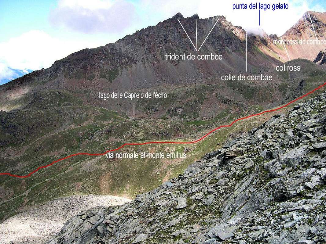
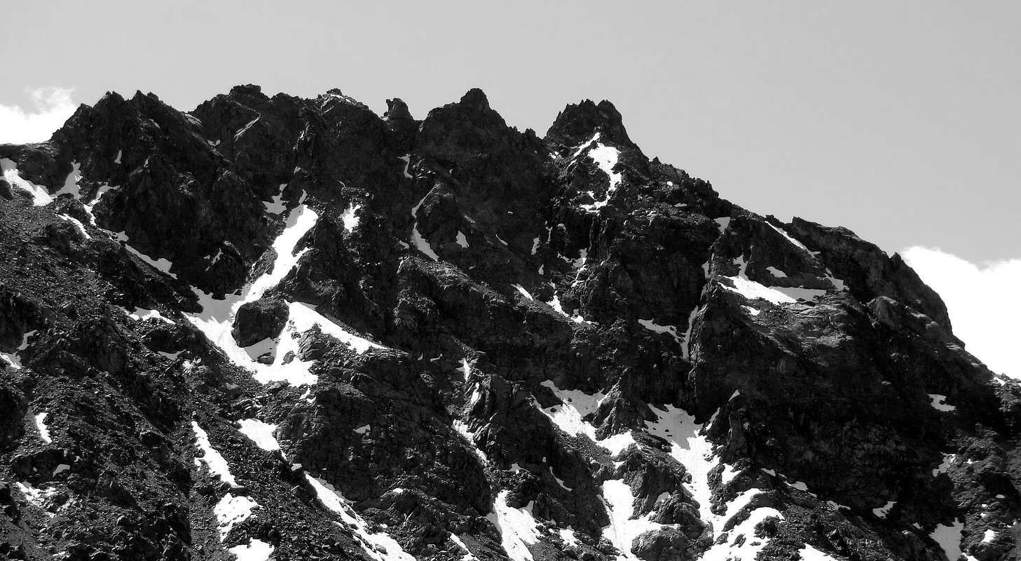
Mountain to horse between the Vallonis of Arbolle and Comboè. Formed by a series of points, towers and pinnacles, it projects toward West a spur of around 700 meters, which divides the Slopes North-northwest and Southwest consist of rocky cliffs broken and very dangerous; the first downhill towards Plan Valé and the Normal Route of Becca di Nona, while the second is directed towards and a small walloon between this summit and the Trident Comboé below of the pass. This side is so well articulated, while on the opposite or Eastern presents a significantly smaller down a short grassy-rocky slope above the rocks of a small valley between secondary Lakes of goats or the Echo and higher "boulders of" and Gelato. Because the rock is not good and the consequent danger of falling stones, the only recommended routes are those on the ridges that rise respectively to the South Col Comboé and on the opposite side from the Col Ròss; also fun and safe climb through the long Spur West-northwest in sight going to Federigo Zullo Bivouac or the Becca di Nona. The other routes, once the "exploratory phase", they have no reason to be popular, because the danger of the same objective goes far beyond the attractions of the ascent and are described here only to complete a systematic analysis of this mountain. It can certainly be useful the descent through the short Eastern Slope, into the walloon below Arbolle, because in case of storm gives a more rapid pace or, more simply, the need to go to the Refuge Arbolle. In any case it's ascension in a very secluded from the masses who can give great suggestions. Good panorama on the Monte Emilius (3.559m), Punta Garin (3.451m) and on the Grivola (3.969m). Good ascent low season (Apr, May, Jun, Oct and Nov) to be in training. Landsacpe excellent in the Southwest Emilius Group; from left: Becca di Nona, Mont Ross de Comboè, South Walls of the Mount Emilius, Punta Rossa, Garin Peak, Arpisson Tower, Plan Bessey Point, Valletta Peak and Testa or Aouille Nera and more in distance Pila wide Basin.
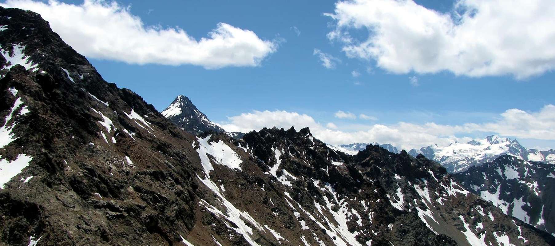
Cima a cavallo tra i Valloni di Arbolle e Comboè. Formata da una serie di punte, torrioni e pinnacoli, proietta verso Ovest uno sperone di circa 700 metri, che divide i due Versanti Nord-nordovest e Sudovest costituiti da pareti di rocce molto rotte e pericolose; la prima scende in direzione di Plan Valé sulla Via Normale della Becca di Nona, mentre la seconda é rivolta verso un valloncello compreso tra questa Sommità ed il Trident di Comboé al di sotto dell'omonimo colle. Questo versante risulta quindi ben articolato, mentre sull'opposto od Orientale si presenta di dimensioni notevolmente più ridotte scendendo con un corto versante roccioso-erboso sopra le pietraie d'un piccolo vallone secondario compreso tra i Laghi delle Capre detto anche dell'Echo ed i superiori "dei Macigni" e Gelato. Causa la roccia non buona ed il conseguente pericolo di cadute di sassi, gli unici percorsi consigliati sono quelli sulle creste che salgono rispettivamente a Sud dal Colle di Comboé e sul lato opposto dal Col Ròss; divertente e sicura inoltre l'ascensione tramite il lungo Sperone Ovest-nordovest bene in vista salendo al Bivacco Federigo Zullo o alla Becca di Nona. Le altre vie, esaurita la "fase esplorativa", non han motivo d'esser frequentate, poiché la pericolosità oggettiva delle stesse supera di gran lunga le attrattive dell'arrampicata e vengon qui descritte solo per completare sistematicamente l'analisi di questa montagna. Può esser sicuramente d'utilità invece la discesa tramite il corto Versante Orientale, verso l'Arbolle, perché in caso di temporali concede più rapida calata oppure, più semplicemente, per la necessità di dirigersi verso il Rifugio di Arbolle. In ogni caso trattasi d'ascensione in ambiente molto appartato dalla massa, tale da donare notevoli suggestioni ed inusuali vedute tutt'attorno. Buon panorama sul Monte Emilius (3.559 m), Punta Garin (3.451 m) e sulla Grivola (3.969 m). Buona gita di mezza stagione (Aprile, Maggio, Giugno, Ottobre e Novembre) per allenamento. Dalle vetta ottimo panorama sul Versante Sudovest del Gruppo dell'Emilius; da sinistra: Becca di Nona, Mont Ròss de Comboè, Pareti Sud dell'Emilius, Punte Rossa, Punta Garin, Guglie d'Arbolle, Torre di Arpisson, Pointes Coupées, Punta di Plan Bessey, Punta della Valletta e Testa Nera o Guglia Nera e più in lontananza l'estesa Conca di Pila.
![]()
First ascents
- First on the Summit: Osvaldo Cardellina and Camillo Roberto Ferronato, (Aug 04th, 1974), in ascent from Trident de Comboé, Comboé Pass and through South Crest.
- In winter: Unknown.
- S Arête (Integral Buttress SW of Monte Emilius): Osvaldo Cardellina and Camillo Roberto Ferronato, (Aug 04th, 1974), in ascent from Pila, Arbolle Walloon.
- SW Face: Osvaldo Cardellina, solo, (Jul 18th, 2006), in ascent from Pila, Comboé and Gran Plan Alps with descent through South Crest to Comboé Pass.
- N-NE Arête (Integral Buttress SW of Monte Emilius): Osvaldo Cardellina and Camillo Roberto Ferronato, (Aug 04th, 1974), in descent to Ròss Pass.
- W-NW Eperon: Osvaldo Cardellina, solo, (Jun 16th, 1996), in ascent from Pila, Comboé, Plan Valé with descent on S-SE Face.
- N-NW Wall: Osvaldo Cardellina, solo, (May 01th, 2008), in ascent from Pila, Gros Scez.
- S-SE Face: Osvaldo Cardellina, solo, (Jun 16th, 1996), in descent.
Getting There
BY CAR:- From Torino, Milano, etc: Motorway A5. Exit at Aosta Est.
- From Switzerland: through the Grand Saint Bernard Tunnel or the namesake Pass.
- From France: through Mont Blanc Tunnel or Petit Saint Bernard Pass. It isn't necessary to take Motorway A5: you can drive on SS.26, in the direction of Aosta.
BY PLANE:
- Aeroporto "Corrado Gex"; Saint Christophe (Aosta).
Approaches
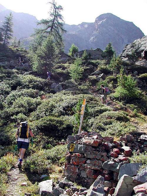
Approach A from Pila Resort through the two Replan Pass: (2.325m) on foot through the various paths n° 19/19A/19B, passing respectively to the Alpage of Chamolé (2.532m; fountain), also towards the Bois (Wood) Chanté, going up directly into a small valley to Chamolé Lake (2.325m). Or to the same point by a Chairlift Chamolé from Pila, starting Bettères. From here the path to the Northeast n° 19 leading to the Hills of Replan; dubbed the small and of the same name pointing to the left to reach the Northern Col and the small winding path always n° 19 off at Comboé (2.114m; private retreat of the Canons of Saint Orso). From this directed to the South with the path and, after rounding a pond, cross the Torrent de Comboé following the path n° 16, which leads to Federigo Zullo Bivouac and Becca di Nona. Won a first slope quite steep and difficult, to achieve the Plan Valé (2.379m); come to the perimeter ruins of an old pasture, or even earlier neighbor the fork 2.329 meters from Grand Plan, through to South or Southeast (depending on the route chosen) bringing near the Tops Lago Gelato (2h'45).Variants:
a) - this trail connection, certainly more "comfortable", but that requires a larger circle first to the South and then returned to the Northeast, you can get to the bottom of the walloon, reaching the Grand Plan from Comboé (calculate half more hour).
b) - Of course you can make the approach starting from Federigo Bivouac (2.907m) nearby the Col Carrel following the path downhill. In this case, you have the advantage of accommodation at a good altitude, bearing in mind that this choice should rise by Ridge North Ròss Pass (3.091m), climbing the pass to the North, being the same twice; after a descent of a few hundred meters from the camp, agrees to go to South East and, passing below the West Face of Mont de Ròss de Comboé remaining at a safe distance from it, climb through steep scree and ribs crushed rock, or through snowfields at the beginning of season.
Avvicinamento A dal Comprensorio di Pila tramite i Colli di Replan: Da Pila (nota località sciistica, raggiungibile da Aosta in auto pullman o funivia), raggiungere il Lago di Chamolé (2.325 m, anche qui in seggiovia o a piedi tramite i vari sentieri n° 19/19A/19B) che passano rispettivamente per l'Alpe di Chamolé (2.532 m; fontana), oppure attraverso il Bois Chanté, salendo direttamente tramite un valloncello al Lago di Chamolé (2.325 m), ove si può giungere anche per mezzo della Seggiovia di Chamolé da Bettères. Da qui inizia verso Nordest il sentiero n° 19 che conduce ai Colli di Replan (pannelli gialli); doppiata la piccola ed omonima punta a sinistra raggiungere il Colle Settentrionale e con il piccolo e tortuoso sentiero sempre n° 19 scendere a Comboé (2.114 m; rifugio privato dei Canonici di Sant'Orso). Da questo indirizzarsi a Sud con il sentiero e, dopo aver doppiato un laghetto, attraversare il Torrent de Comboé seguendo il sentiero n° 16, adducente al Bivacco Federigo ed alla Becca di Nona. Vinto un primo pendio alquanto ripido e faticoso, raggiungere Plan Valé; alle rovine perimetrali d'una antica alpe (2.379 m), oppure anche prima al bivio 2.329 metri collegante l'Alpe Grand Plan, attraversare a Sud o Sudest (a seconda della via prescelta) portandosi verso le Punte del Lago Gelato (2h'45).
Varianti:
a) - a questo sentiero di collegamento, sicuramente più "comodo", ma tale da richiedere un giro più largo dapprima verso Sud per poi rientrare verso Nordest, si può arrivare raggiungendo sul fondo del vallone il Grand Plan da Comboé (calcolare mezz'ora in più).
b) - Logicamente si può effettuare l'avvicinamento partendo dal Bivacco Federigo Zullo (2.907 m) al Colle Carrel seguendo il sentiero in discesa. In questo caso si ha il vantaggio del pernottamento ad una buona quota, tenendo presente che con questa scelta conviene salire tramite la Cresta Nord dal Col Ròss (3.091 m), salendo al colle Settentrionale, essendo il medesimo doppio; dopo una discesa d'un centinaio di metri dal bivacco, conviene dirigersi a Sudest e, passando al di sotto della Parete Ovest del Mont Ròss de Comboé, risalire tramite ripide pietraie e costoloni di roccia frantumata, oppur tramite nevati.
![Along the pathway to Becca di Nona <i>3142m</i>]() Approach B Arbolle Refuge: It is also possible to get off the Refuge Arbolle 2.516m with a small path n° 18 which runs to the North and, after reaching the Alp Grand Plan (2.158m; remains) through a narrow gorge, crossing the Torrent de Comboé with a diagonal from right to left in the middle of a heap of stones; From this point the path part of a diagonal n° 18 (yellow signals immediately to the East alp), which is directed towards Plan Valé and Federigo camp. Take the same for about two-thirds to go up directly to the Punte del Lago Gelato first through bushes and trees and then through large rocks, or reach the Plan Valé and then navigate to the right (South; EE; calculated for both 1h'30 1h'45 to the shelter).
Approach B Arbolle Refuge: It is also possible to get off the Refuge Arbolle 2.516m with a small path n° 18 which runs to the North and, after reaching the Alp Grand Plan (2.158m; remains) through a narrow gorge, crossing the Torrent de Comboé with a diagonal from right to left in the middle of a heap of stones; From this point the path part of a diagonal n° 18 (yellow signals immediately to the East alp), which is directed towards Plan Valé and Federigo camp. Take the same for about two-thirds to go up directly to the Punte del Lago Gelato first through bushes and trees and then through large rocks, or reach the Plan Valé and then navigate to the right (South; EE; calculated for both 1h'30 1h'45 to the shelter).
Avvicinamento B dal Rifugio di Arbolle: Inoltre é possibile scendere dal Rifugio d'Arbolle con un piccolo sentiero n° 18 che gira verso Nord e, dopo aver raggiunto l'Alpe diroccata di Grand Plan (2.158 m) tramite una stretta gola, attraversa il Torrent de Comboé con un diagonale da destra verso sinistra in mezzo ad una pietraia; da questo punto parte un il sentiero diagonale n° 18 (cartello giallo subito ad Est dell'alpe) indirizzantesi verso Plan Valé ed il Bivacco Federigo. Percorrere il medesimo per circa due terzi per poi salire direttamente verso le Punte del Lago Gelato dapprima tramite cespugli ed alberi e poi tramite grandi pietraie, oppure raggiungere il Plan Valé e poi traversare a destra (Sud; EE; calcolare per entrambi da 1h'30 a 1h'45 dal rifugio).
Approach C from Pila through Plan Fenêtre Pass or from Ponteilles to the Valley of Comboé: Pila catch up with the previous Approach A to Chamolé Pasture (2.532m); leaving right (South) detours to Lake Chamolé continue instead with the path n° 20 to the Northeast, that reached the junction in altitude 2.059 metres with the private dirt road that goes from the Pasture and from the Hermitage of San Grato (1.787m), is entered in the woods, with almost flat and undulating path, arrive at the next fork at 2.140 meters, where the steep trail that climbs from the latter. With a final stroke on a slight slope and panorama you get to the Hill Plan Fenêtre (2.229m), hence with quiet down in the Southeast are within the Valley and Alp Comboé (2.114m), where you reconnect with the previous Approach A.
Variants starting from below:
a ) - this path you can get, as mentioned above, by means of a private dirt road that stretches from San Grato (1.787m), or by means of steep unnumbered mule-track that goes through the Black Forest Combatissière just Eastward.
b) - It is also possible to reach the Valley Comboé from this of Dard, the one below it, with different starting points, reaches Alp Ponteilles and its beautiful waterfall (1.697m, around 1.640 meters); a path numbered 14D bastion dating this charming coming to Comboé Dessous (Low, 2.041m) at the entrance of the walloon immediately below and to the prairies Comboé (1h'00/1h'10 from Ponteilles Alpage).
Avvicinamento C da Pila attraverso il Col Plan Fenêtre o da Ponteilles al Vallone di Comboé: da Pila raggiungere con il precedente Avvicinamento A l'Alpe di Chamolé (2.532 m); lasciando a destra le deviazioni per il Lago di Chamolé, continuare invece verso Nordest con il sentiero n° 20 che, raggiunto il bivio con la strada poderale che risale dall'Alpe e dall'Eremitaggio di San Grato in altitudine 2.059 metri, si immette nel bosco e, con percorso ondulatorio e quasi pianeggiante, arriva al successivo bivio 2.140 metri dove perviene la ripida mulattiera che sale da questi ultimi. Un ultimo tratto in falsopiano e panoramico porta al Colle Plan Fenêtre (2.229 m), donde con tranquilla discesa a Sudest si raggiungono il Vallone e l'Alpe di Comboé (2.114 m), dove ci si riconnette col precedente Avvicinamento A.
Varianti partendo da più in basso:
a ) - a questo sentiero si può arrivare, come detto sopra, tramite una strada poderale che parte da San Grato (1.787 m), oppure per mezzo della ripida mulattiera non numerata che sale attraverso la Foresta Nera di Combatissière appena più ad Oriente,
b ) - Inoltre é possibile raggiungere il Vallone di Comboé da quello sottostante del Dard che, con vari punti di partenza, perviene all'Alpe di Ponteilles ed alla sua bella cascata (1.697 m, 1.640 metri circa); un sentiero n° 14D risale questo spalto suggestivo arrivando al Comboé Dessous (di Sotto; 2.041 m) all'ingresso del vallone e subito appresso per praterie al Comboé (1h'00/1h'10 dall'Alpe di Ponteilles).
 |
 |
 |
 |
 |
Routes
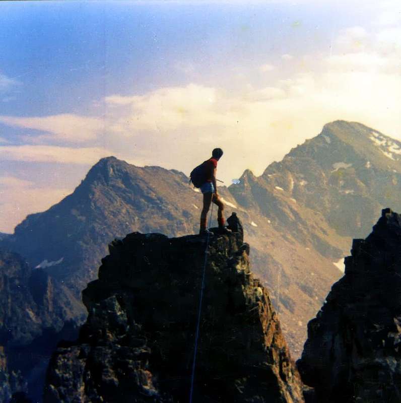
Route A: South Crest from Comboé Pass or Standard Route: From Pila (famous ski resort easy and fastly reachable from Aosta using car, bus or cableway), to reach the of Comboè Valley. Just before the Plan Valè (2.379m) to cross toward South on broken rocks in direction of the base of the Spur West-northwest. Dub to the right (South-southeast) reaching the same stony gray set between altitudes of 2.510/2.536 meters; at this point can get going straight from the diagonal path n° 16 which rooms from Alp of Gran Plan (2.158m; see various Approaches) by a moraine slope or a little further, steep channels with debris and rhododendrons. From this "large narrowing" climb Eastward beneath the spur reaching a stone of dark red rocks located on the Northern margin of the basin above between the Tops of Lago Gelato and Trident de Comboé. With uphill boring and tiring reach the pass by means of a groove in the terminal part gravelly (3.014m; 2h'15/2h'30 from Gran Plan). Begin the ascent of the South Crest via a reddish plaque (III°/III°-) reaching a rounded shoulder, then to continue on the ridge rocks for easier (I°+/II°) which, after passing two small bumps engraved together by a notch, reaching the South Top, the highest (A/PD; 0h'30/0h'45 from the pass; 3h'15/3h'30 Comboé).Descent: South Arête (II°- for 25m~) and E Wall (II°+ for 120m~) better or crossing from Summit (six little Summits, II°+) to Ròss Pass.

Via A: Cresta Sud dal Colle di Comboé o Via Normale: Da Pila (nota località sciistica, raggiungibile da Aosta in auto, pullman o funivia), raggiungere il Vallone di Comboè. Poco prima del Plan Valè (2.379 m), attraversare verso Sud su pietraie in direzione della base dello Sperone Ovest-nordovest; doppiare a destra (Sud-sudest) il medesimo raggiungendo una pietraia grigiastra sita tra le quote di 2.510/2.536 metri; a questo punto di può arrivare salendo direttamente dal sentiero diagonale n° 16 che proviene dall'Alpe di Gran Plan (2.158 m; vedi Avvicinamenti vari) tramite un pendio morenico o, poco più avanti, ripidi canali tra detrito e rododendri. Da questa "larga strettoia" salire verso Est al di sotto dello sperone raggiungendo una pietraia di rocce dal caratteristico colore rosso scuro situata sul margine Settentrionale del soprastante bacino compreso tra le Punte del Lago Gelato ed il Trident de Comboé (3.083 m, 3.070 m~, 3.057 m). Con salita noiosa e faticosa raggiungere il colle per mezzo d'un canalino ghiaioso nella parte terminale (3.014 m; 2h'15/2h'30 dal Gran Plan). Iniziare la salita della Cresta Sud tramite una placca rossastra (III°/III°-) raggiungendo una spallone arrotondato, per successivamente proseguire sul filo di cresta per rocce più facili (I°+/II°) che, dopo aver superato due piccole asperità incise tra di loro da un intaglietto, raggiungono la Sommità Meridionale, la più elevata (A/PD-; 0h'30/0h'45 dal colle; 3h'15/3h'30 dal Comboé).
Discesa: Per la Cresta Sud (II°- per 25m~) e per la piccola Parete Est (II°+ per 120 metri~) meglio, oppure in traversata dalla vetta (sei piccole punte, II°+) al Col Ròss.
Route B: Southwest Face from Comboé through Plan Valé or from Gran Plan: This rough and abrupt slope falling over the small basin-walloon between Lake Gelato Tips and Trident de Comboé (see previous route A) and below the Pass of Comboé. You can come up with a divergence to the left of the path that leads to the latter. Climb between two rock outcrops that come from the Spur West-northwest and the South Crest from Comboé Pass. The ascent has no set path but requires the ability to know how to choose the best way, always keeping in mind that there is a significant danger of falling stones, because much material suspended above a small ledges covered with fine debris. It should then stand on top of the lateral ribs avoiding, as far as possible, the path inside the couloirs. It is an uphill one time, as incidentally almost all the routes in this mountain a little known and even less crowded. Or, as in the first climb, stand in the middle of the wall using a crest in the form of a small pillar of 210/20 meters~ that leads directly to acute final tower you win you stand on the left and with much caution, because the fragility real of the rock composed of reddish chips (II°/II°+/III°-, depending on the selected passages; 2h'00/2h'15 from the base; 5h'00/5h'30 from Pila Pila Resort; 3h'45 in the first ascent).

Via B: Faccia Sudovest dal Comboé per il Plan Valé o dal Gran Plan: Questo sconnesso e dirupato versante cade sopra il piccolo bacino-vallone compreso tra Punte del Lago Gelato e Trident de Comboé (vedi precedente itinerario) ed al di sotto del Colle di Comboé. Si può salire con una divergenza a sinistra dalla via che conduce a questo ultimo. Salire in mezzo a due costole rocciose che provengono dallo Sperone Ovest-nordovest e dalla Cresta Sud. La scalata non possiede percorso obbligato ma richiede la capacità di sapere scegliere la miglior via, sempre tenendo presente che esiste un significativo pericolo di cadute di pietre, causa il materiale sospeso sopra a delle cengette detritiche. Conviene quindi appoggiare sui costoloni latareli evitando, per quanto possibile, il percorso dentro i canali. Risulta salita un'unica volta, come daltronde per quasi tutte le vie a questa montagna poco conosciuta ed ancor meno frequentata. Oppure, come nella prima ascensione, restare nel mezzo della parete utilizzando una cresta-pilastro di 210/20 metri~ conducente direttamente all'acuta torretta finale che si vince appoggiando sulla sinistra facendo attenzione alla fragilità della roccia (II°/II°+/III°- a seconda dei passaggi scelti; 2h'00/2h'15 dalla base, 5h'00/5h'30 da Pila; 3h'45 Pila nella prima salita).
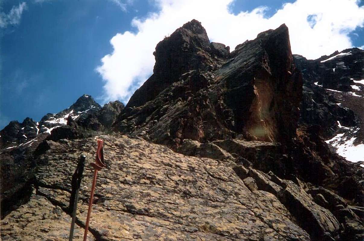
Route C: West-Northwest Spur-Éperon from Comboé through Plan Valé: From Pila to reach the Comboè Walloon. From this continue, through the Torrent de Comboé over a small wooden bridge, to the East by a steep path unnumbered for the Becca di Nona and Federigo Zullo Bivouac; this won the first rampart through the woods to join 2.329 meters in altitude connecting with the diagonal path n° 16 which comes from the Grand Plan. Continue for a short distance with the same and, just before the Plan Valè (2.379m) to cross toward South on broken rocks in direction of the base of the Spur West-northwest; to go up again to a wide saddle (little fellow) and to easily reach a small pinnacle to "tooth of shark", South to go around. To avoid the small opposed wall and to climb a small tower (I°/II°) reaching the Quota 2.849m, where the crest of it divides; to overcome a forked pinnacle divided by a dyedral (II°/III°). One "Brèche", a small tower, a series of small turrits and indented pinnacle a snowy couloir, almost always (60°), they conduct to the final wall of around 25 meters and immediately later to the peak (III°+; 2h'30/3h'00 from base, 5h'30/6h'00 from Pila; 3h'15 Pila in the first ascent). This route it becomes interesting and fun start to the season (generally from 10 June to mid-July), while losing value in the absence of snow; on the other hand is to be avoided when the slopes are too swollen and frames (to get around to the North between two rocky pinnacles, which would otherwise require higher difficulties) are too big and dangerous. In this case, continue with steps on the ridge also III°+/IV°-/IV° (in the "first" have been bypassed North, almost all less the first, through always steep ramps). Climbing less difficult that an analysis from the bottom, but never trivial and requires the ability to know how to choose the right sequence of steps. In any case, should knowledge of the way down that it is not difficult but it does require to identify the right route, not always easy and obvious.

Via C: Sperone Ovest-nordovest dal Comboé attraverso il Plan di Valé: Da Pila raggiungere il Vallone di Comboè. Da questo proseguire, passando il Torrent de Comboé sopra un ponticello in legno, verso Est tramite un ripido sentiero non numerato per la Becca di Nona ed il Bivacco Federigo Zullo; questo vince un primo spalto attraverso il bosco andandosi a congiungere a quota 2329 metri con il seniero diagonale n° 16 proveniente dal Gran Plan. Continuare per breve tratto con il medesimo e, poco prima del Plan Valè (2.379 m), attraversare verso Sud su pietraie in direzione della base dello Sperone Ovest-nordovest; risalire a una larga sella (ometto) e raggiungere facilmente un piccolo monolite a "dente di squalo", aggirabile a Sud. Evitare la paretina opposta e salire un torrioncino (I°/II°) raggiungendo la Quota 2.849 m, ove la cresta di divide; superare un gendarme bifido diviso da un diedro (II°/III°). Una "Brèche", un piccolo torrione, una serie di torrette e gendarmi dentellati e un canalino, quasi sempre nevoso (60°), conducono alla parete finale di circa 25/30 metri e subito dopo alla Vetta (III°+; 5h'30/6h'00; 3h'15 nella prima salita). Questa via diventa interessante e divertente in inizio di stagione (generalmente dal 10 Giugno a metà di Luglio), mentre perde valore in assenza di neve; per contro é da evitarsi quando i pendii sono troppo gonfi e le cornici (da aggirarsi sempre a Nord tra due tratti rocciosi, che altrimenti richiedono più elevate difficoltà) sono troppo grandi nonché pericolose. In questo caso proseguire sul filo con passaggi anche di III°+/IV°-/IV° (nella "prima" sono stati aggirati a Nord, quasi tutti tranne il primo, per rampe in diagonale sempre molto ripide). Salita meno difficile che da analisi dal basso, ma mai banale richiedente capacità di sapere scegliere la giusta successione dei passaggi, non sempre facile e scontata.
Route D: North-northwest Face through the fork towards Gros Scez: This slope is between the previous outcrop and the Northeast Ridge, which rises very rugged Ròss Pass; in sight going to Becca di Nona, is formed by a long initial slope of ~350 meters, gradually increasing in steepness (from 30°~ to 45~ and even more), the basal moraine rises to "break" against a wall of broken rocks very high 260 meters~. The last part consists of a small castle square of red rocks for forty meters~, which also comes Spur West-northwest, consisting of shale and very steep and very fragile. A total of 600 meters~ of climb, which require a good transformation of the snow in the first part and a certain "cleaning" of the rocks in the next, since the entire ascent is always very exposed to falling stones and requires the ability to know how to choose the best path depending on the conditions of snow. It can be considered a good uphill workout start to the season. From the path n° 16/16A for Federigo Camp to the Grand Scez also "The Grand Sax (2.526m), or before facing the promontory that rises from the Plan Valé here, and from this point, leaving the same, through a couple of channels are marked by debris avalanches coming down from above Ròss Pass, with Southeast direction to reach the point 2.858 meters at the base of a rocky outcrop that is separated from the secondary Spur West-northwest. Rounding on the left (East) and with the same slope that gradually increases in steepness (40°~, with hard snow better to use crampons) to reach a high rib winding a hundred meters~, flanked on either side by two grooves; follow quite easily over it, or through the gullies, reaching a rocky than 20 meters~. Overcoming the same (II°-) coming in the middle of a horizontal debris ledge, which you follow to the left. A subsequent arched groove on the left (50°/45°/40°) and broken by two short rock bands leads to the base of the small tower is won with climbing more delicate that difficult (II°/II°+; 3h'30/4h'00 base; 6h'45/7h'15 Pila). Climbing that requires experience; certainly not aimed at being too large, because of the danger in the passage of suspended materials move.

Via D: Faccia Nord-nordovest dal Comboé attraverso il bivio per Grand Scez: Questo versante viene compreso tra il precedente sperone e la Cresta Nordest, che sale molto frastagliata dal Col Ròss; bene in vista salendo alla Becca di Nona, é formato da un lungo pendio iniziale di 350~ metri che, aumentando progressivamente in ripidezza (da 30°~ a 45°~ ed anche più), dalle morene basali sale fino ad "infrangersi" contro una parete di rocce molto rotte, alta 260~ metri. L'ultima parte consiste in un castelletto squadrato di rocce rossicce per una quarantina di metri~, ove arriva anche lo Sperone Ovest-nordovest, formato da rocce scistose e molto ripide nonché alquanto fragili. Complessivamente 600~ metri di salita, che richiedono una buona trasformazione della neve nella prima parte ed una certa "pulizia" delle rocce nella successiva, poiché l'intera ascensione risulta sempre molto esposta alla caduta di pietre e richiede capacità di saper scegliere il percorso migliore a seconda delle condizioni dell'innevamento. Può essere considerata buona salita d'allenamento in inizio di stagione, ma dev'esser scartata in condizioni di neve non ottimali. Dal sentiero n° 16/16A per il Bivacco Federigo raggiungere il Grand Scez o "le Grand Sax (2.526 m), oppure già prima d'affrontare il promontorio che qui sale dal Plan Valé, e da questo punto, abbandonando lo stesso, attraversare un paio di canali detritici segnati dalle valanghe discendenti dal soprastante Col Ròss; con direzione Sudest raggiungere il punto 2.858 metri alla base di uno sperone roccioso secondario che si distacca dallo Sperone Ovest-nordovest. Doppiando sulla sinistra (Est) il medesimo e con salita che progressivamente aumenta in ripidità (40°; con neve dura meglio utilizzare i ramponi) raggiungere una costola sinuosa alta un centinaio di metri, affiancata sui due lati da due canalini; seguire abbastanza facilmente sopra la medesima, oppure tramite i canalini, arrivando ad un salto roccioso di una ventina di metri. Superare lo stesso (II°-) arrivando nel mezzo di una larga sella detritica orizzontale, che si segue verso sinistra. Un successivo canalino inarcato a sinistra (50°/45°/40°) e spezzato da due corte fasce rocciose conduce alla base della torretta sommitale, vincendola con arrampicata più delicata che difficile (II°/II°+; 3h'30/4h'00 dalla base; 6h'45/7h'15 da Pila). Ascensione sempre delicata e pericolosa.
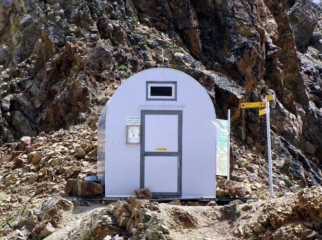
Route E: Northeast Ridge from Ròss Pass: This path may itself be regarded as "Normal Route", though longer and "articulated" the former Via A. Definitely should use the same starting after a short descent from Federigo Zullo Bivouac (2.907m) to the Col Carrel; but you can also make the same starting from Refuge of Arbolle through a long ride in the homonymous walloon in the first part of the path that leads to Monte Emilius (3.559m). In this case you have to abandon the path n° 14 at the junction between the Barracks "Modzon" and "des Pouleins" in altitude of 2.600/50 meters; left to right (East) of the route to the Garin Hill, one enters a small stony walloon that leads to the "Lago delle Capre" or Lake of the Goats also called the Echo Lake (2.702m). Continuing North under the Trident de Comboé you get to the smallest of the "Lakes of Boulders" (2.957m), with a climb of steep grassy slopes to reach the Col Ròss (3.091m); always the same you reach the opposite side, or Western, climbing the steep slopes debris or snowfields above the Grand Scez (see itinerary above). From the Northern Col Ròss move to the adjacent South (can not be used for transit Comboé/Arbolle and vice versa) and go through an initial series of five small prominences reaching a detrital rounded sadlle; the two subsequent and more squared elevations lead to a first carving that precedes a characteristic head in the manner of "roaring lion", in turn followed by a second notch. A less steep ridge reaches a sharp point and triangular, above which a collar much more marked above the small tower Summit, consisting of half a dozen small elevations, the highest of which is the last or the South. Should always keep in climbing the ridge on the thread of the edge for about 200 meters linear because in circumvention of both sides, the rock is not good gets even worse (PD-/PD+, exposed in some places; 1h'45/2h'15 from Bivouac; 0h'45/1h'15 from Ròss Pass; 6h'00/6h'30 from Pila).
Via E: Cresta Nordest dal Col Ròss: Questa via può essere a sua volta considerata come "Via Normale", anche se più lunga ed "articolata" della precedente Via A. Sicuramente conviene utilizzare la stessa partendo, dopo una breve discesa, dal Bivacco Federigo Zullo (2.907 m) al Colle Carrel; ma é possibile effettuare la medesima anche partendo dal Rifugio di Arbolle tramite un lungo giro nell'omonimo vallone nella prima parte del sentiero conducente al Monte Emilius (3.559 m). In questo caso si deve abbandonare il sentiero n° 14 al bivio tra le Baracche "Modzon" e "des Pouleins" in altitudine 2.600/50 metri~; lasciando a destra (Est) la Via pel Col Garin, si entra in un valloncello petroso che conduce al Lago delle Capre pur detto Lago dell'Echo (2.702 m). Continuando verso Nord sotto il Trident de Comboé si arriva al più piccolo dei "Laghi dei Macigni" (2.957 m) e con una salita tra ripidi pendii erbosi si raggiunge il Col Ròss (3.091 m); sempre al medesimo si giunge dal versante opposto, ovvero Occidentale, salendo i ripidi pendii detrici o per nevai sopra il Grand Scez (vedi itinerario precedente). Dal Col Ròss Nord passare all'adiacente Sud (non utilizzabile per il transito Comboé/Arbolle e viceversa) ed attraversare una prima serie di cinque piccole asperità raggiungendo una sella detritica arrotondata; le due successive e più squadrate elevazioni conducono ad un primo intaglio che precede una caratteristica testa a guisa di "leone che rugge", a sua volta seguita da una seconda incisione. Una cresta meno ripida raggiunge una punta acuta e triangolare, oltre la quale un colletto ben più marcato precede la piccola torre sommitale, formata da una mezza dozzina di puntine, la più alta delle quali risulta l'ultima o Meridionale. Conviene sempre mantenere durante l'arrampicata il filo di cresta per circa 200 metri lineari poiché, negli aggiramenti su entrambi i lati, la roccia non buona diventa ancor peggiore (PD-/PD+, a tratti esposto; 0h'45/1h'15 dal Col Ròss; 1h'45/2h'15 dal Bivacco).
Route F: small Face East-southeast: This short-facing slope above the rocks Lakes Gelato and "of the Boulders" in the mid-West Valley Arbolle is formed by steep slopes with grassy-rocky ledges different. High a few hundred meters can only be useful to make a rapid descent due to the sudden arrival of bad weather (as in the case of the single path so far made) with subsequent crossing the nearby Ròss Pass (3.091m) to reach the Federigo Bivouac (2.907m); otherwise it is much to be discarded, taking over that in the event of rain and to avoid the danger of lightning on spiers, the slope becomes delicate and dangerous, requiring a "good mountain foot" (0h'20; 0h'40 with short climb to the Col Ròss; 1h'10/1h'20 for the return to bivouac).
Via F: Paretina Est-sudest: Questo corto versante rivolto sopra le pietraie dei Laghi Gelato e "dei Macigni" nel medio-Occidentale Vallone di Arbolle é formato da ripidi pendii erboso-rocciosi con diverse cenge. Alto un centinaio di metri può essere esclusivamente di utilità per effettuare una rapida discesa dovuta allo arrivo improvviso di maltempo (come nell'unico probabile percorso sino ad ora effettuato) con susseguente traversata al Col Ròss per raggiungere il Bivacco Federigo; altrimenti é decisamente da scartare, tenendo in oltre presente che in caso di pioggia il pendio diventa delicato e pericoloso, tale da richiedere un "buon piede da montagna" (0h'20; 0h'40 con breve risalita al Col Ròss; 1h'10/1h'20 per rientrare al Bivacco Federigo).


L'itinerario è classificato PD-/PD+ (Poco Difficile+) ad AD (Abbastanza Difficile) dipende dalle condizioni della montagna, nonché dall'itinerario prescelto.
Equipment
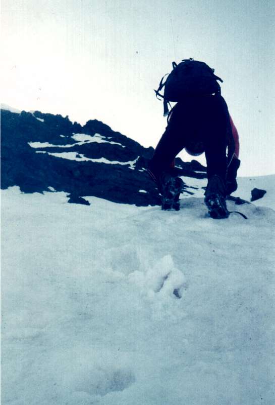
Mountaineering: Rope, at the beginning of springtime (Apr, May, Jun) ice axe and crampons.Da alpinismo: corda, in inizio stagione (Aprile, Maggio, Giugno) picozza e ramponi.
![]()
Huts
Campings
Remember that free camping is forbidden (except for emergency reasons, over 2.500m, from darkness until dawn).Mountain Condition
- Meteo: you can find all the needed informations at the official site of the Valle d'Aosta Region:
- Valle d'Aosta Meteo
Webcam
- WEBCAM on Aosta Valley:
- Webcam
Books and Maps
BOOKS:- "Guida del Monte Emilius", di Osvaldo Cardellina Editore in collaborazione con il Club Alpino Italiano Sezione di Aosta, Dicembre 1978.
- "Guida dei Monti d'Italia – Emilius Rosa dei Banchi Parco del Mont Avic" di Giulio Berutto e Lino Fornelli - Club Alpino Italiano/Touring Club Italiano, Marzo 2005.
- "Guida delle Alpi Occidentali" di Giovanni Bobba e Luigi Vaccarone C.A.I. Sezione di Torino Volume II (parte II), 25 Maggio 1896.
- "Diari Alpinistici" di Osvaldo Cardellina e Indice Generale accompagnato da Schedario Relazioni Ascensioni 1964-2019 (inediti).
- "80 itinerari di Escursionismo Alpinismo e Sci Alpinismo in Valle d'Aosta", di Osvaldo Cardellina, Ed. Musumeci, Giugno 1977 (in Italian); seconda Ed. Luglio 1981; terza Ed. Luglio 1984; (in French), prima Ed. Febbraio 1978; seconda Ed. Marzo 1980.
 |
 |
 |
 |
MAPS:
- Kompass "Gran Paradiso Valle d'Aosta Sentieri e Rifugi" Carta turistica 1:50.000.
- L'Escursionista "Conca di Aosta-Pila-Monte Emilius" Carta dei sentieri (n° 4) 1:25.000.
- Hapax "Les Sentiers Comunità Montana Monte Emilius", Luglio 2000 1:25.000.
- Enrico Editore Ivrea-Aosta "Gruppo del Gran Paradiso" 1:50.000.
- I.G.C. Istituto Geografico Centrale, Torino "Carta delle Passeggiate ed Escursioni in V.D.A. Conca di Pila-Gressan, 1:20.000.
Important Information
- REGIONE AUTONOMA VALLE D'AOSTA the official site.
- FONDAZIONE MONTAGNA SICURA Villa Cameron, località Villard de la Palud n° 1 Courmayeur (AO) Tel: 39 0165 897602 - Fax: 39 0165 897647.
- A.I.NE.VA. (Associazione Interregionale Neve e Valanghe).
Useful numbers
- Soccorso Alpino Cogne (SAR) Tel. 3482685406.
- Protezione Civile Valdostana località Aeroporto n° 7/A Saint Christophe (Ao) Tel. 0165-238222.
- Bollettino Meteo (weather info) Tel. 0165-44113.
- Unità Operativa di Soccorso Sanitario Tel. 118.
Acknowledgements
I am greatly indebted to my friend "Osva" for the detailed description of the route all texts and translation into English.