
-
 7962 Hits
-
 85.36% Score
-
 20 Votes
|
|
Mountain/Rock |
|---|---|
|
|
45.66493°N / 7.38659°E |
|
|
11047 ft / 3367 m |
|
|
Overview
The Punta di Laures is a regular pyramid, with three crests and three walls not to confuse with the Eastern Summit of the Emilius Red Point, as often happened in old times causing a some confusion. The standard route considering oneself the E Ridge descending steep enough on Laures Pass (3.036m); towards South direction project a long and indented rocky spur, ending near the quota 3.115m, over the Lussert Higher Lake also Four Lake (2.926m). The last and brief crest, by NW direction, after a descent to small Saddle 3.250m~, crossing two rocky pinnacles, go up on nearby Eastern Punta Rossa dell'Emilius (3.399m) by her own S-SE Ridge. From its peak a magnificent panorama on the Gran Paradiso Group and on the near Emilius Mountain, Roèses small Group, Leppe Point, on more distant Tersiva Point and more close Grauson Tower and Garin Peak. Marvellous at a glances to Laures Lakes in Northeast and on Lussert Lakes in Southeast, with colours changing from green emerald to the most a deep azure. Uncontaminated natural habitat nearby the Turati Wildlife Reseve, into Saint Marcel Valley, therefore easily to meet with ibex or chamois flocks, let alone with other species wich the marmot and the squirrel; amongst the birds predominate Royal Eagles, gypetus, little hawks, imperial crows, partridges and forcellum cocks and grouses.
La Punta di Laures è una piramide regolare con tre creste e tre pareti da non confondersi con la Punta Est della Punta Rossa dell'Emilius (3.399 m), come é successo spesso nel passato creando una certa confusione tra le due punte. La via normale è da considerarsi la Cresta E che scende abbastanza ripida sul Col des Laures (3.036 m); a S proietta un lungo e frastagliato sperone roccioso, terminante presso la quota 3.115 m sopra il Lago Alto dei Lussert o Quarto Lago (2.926 m). L'ultima breve cresta con direzione NW, dopo essere scesa alla piccola Sella 3.250 m~ superando due arditi torrioni rocciosi, risale alla vicina Punta Est della Punta Rossa dell'Emilius tramite la cresta S-SE di quest'ultima. Dalla sua vetta si gode un magnifico panorama sul versante SE del Massiccio del Gran Paradiso e sui vicini Monte Emilius, sul piccolo Gruppo delle Roèses, Punta di Leppe, sulla più lontana Punta Tersiva, ed i vicinissimi Tour Grauson e Punta Garin. Grandi colpi d'occhio sui Laghi delle Laures e del Lussert, dai colori cangianti dal verde smeraldo all'azzurro più intenso. Essendo un habitat naturalistico ancora incontaminato e viciniore alla Riserva Turati dentro la Valle di Saint Marcel, non é da escludersi l'incontro con branchi di camosci o stambecchi, nonché altre specie di animali quali la marmotta o lo scoiattolo; ricca anche l'avifauna, sulla quale predominano aquile reali, gipeti, falchetti, corvi imperiali, pernici, gallo forcello e cedrone.
First Ascents
- First on the summit: Unknown.
- In winter: Unknown.
- E-SE Arête: Osvaldo Cardellina, Danilo Garzotto and Natalino Massoni, Oct 09th, 1994, in day from Gimillan, Ecloseur, Grauson Vieux and Nuove Pastures, three Lussert Lakes, Laures Pass; in descent same route to Col des Laures. First solo: Osvaldo Cardellina, lone, Aug 02th, 2009, in day from Gimillan Hamlet, Lussert three Lakes, Col des Laures and crossing (first solo) to Punta Rossa dell'Emilius Eastern, Central, Western Summits, round trip; after with descent to Arbolle Pass through NE Crest and traverse to Laures Pass, three Lussert Lochs, Grauson Nuove and Vieux Alps, Gimillan.
- S-SW Eperon: Osvaldo Cardellina and Camillo Roberto Ferronato, Jul 25th, 1976, in day from Gimillan, Grauson Vieux and Nuove Alps, fourth Lussert Loch; after with crossing always on watershed to Punta Rossa, Mount Valaisan and Punta Garin and finally to Lussert by NW Edge and Northern Slope.
- SW Wall (Direct to Summit): Osvaldo Cardellina, lone, Jul 07th, 1998, in day from Pila, Chamolé Hill, Arbolle and through the Valaisan Pass.
- SW Wall (Collar 3.325/30m~ near Red Tower 3.340/45m~) and NW Crest: Osvaldo Cardellina, lone, Jul 09th, 2005, in day from Gimillan Hamlet, Grauson Vieux and Nuove Alps, Higher (2.923 meters~) amongst the four Laures Lochs; in descent E Ridge to Col des Laures and same route to Gimillan .
- N-NW Arête (in descent from the Top and crossing to Punta Rossa, Mount Valaisan and Punta Garin): Osvaldo Cardellina and Camillo Roberto Ferronato, Jul 25th, 1976, in day from Gimillan, Grauson Vieux and Nuove Pastures, Lussert Lago Alto (2.923 meters~), S-SW Spur to Summit.
- N-NE Face (Diagonal Route from left or Est to Reddish Tower 3.340/45m~) and NW Crest in final part: Osvaldo Cardellina and Alessandro Cardellina, Jul 21th, 2006, in day from L'Arp, Tramouail, Les Laures Lochs; in descent E-SE Crest to Laures Pass, Lacs d'en Haut, Long, Dessous, Refuge E. Menabreaz.
- N-NE Wall (Direct Route): Osvaldo Cardellina, lone Oct 10th, 2007, in day from Pila, by Arbolle Pass, and crossing to Emilius three Red Points.
Getting There
BY CAR:- From Torino, Milano, etc: Motorway A5. Exit at Aosta Ovest. Drive to the nearby Aymavilles. Follow in the directions for Valle di Cogne.
- From Switzerland: through the Grand St. Bernard Tunnel or the namesake pass). Drive to Aosta, then follow signs for Courmayeur along SS.26. Just past Sarre, turn left, in the direction of Valle di Cogne.
- From France: through Mont Blanc Tunnel or Petit St. Bernard Pass). It isn't necessary to take Motorway A5, you can drive along SS.26 in the direction of Aosta. Before reaching the Village of Sarre, follow the sign and turn right towards Valle di Cogne. After Aymavilles, SR.47 crosses the Villages of Vieyes (1.142m), Epinel (1.452m) and Cretaz (1.499m) and then arrives at Cogne (1.534m) after a total of about 25 Km. Follow the road signs for Gimillan and Lillaz to a round-about, recently built in proximity of the St. Anthony Chapel, then go left along the scenic route leading to the Village of Gimillan (1.787m), 3 km from Cogne. Usually no parking problems.
BY PLANE:
- "Corrado Gex" Airport, Saint Christophe (Aosta).
 |
Approachs
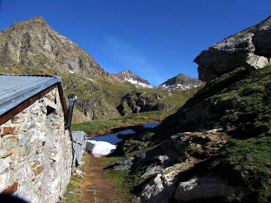
1) - From Gimillan (1.787m): go right starting from the car park of Gimillan (wooden bridge 1.820m~): after few meters the indications for Lussert Lakes, St. Marcel Pass, etc. are found. The pathway is indicated by the yellow circle 9A and by yellow strips marked on stones along the route. The path begins going immediately uphill, then the slope decreases as we go beyond a little Chapel dedicated to the Virgin (1.836m). Soon the path resumes to go up and splits in two, before it begins to penetrate into the Grauson Valley: it's possible to continue following the right one that goes down as far as the Ecloseur Bridge (1.904m), but in such a case we must go up again; it's better to follow the left one that, in practice without losing height, arrives at the bridge under the Alpeggio Pila (2.025m), cross it and, following the stepped pathway, overcome the rocky bastion beside a fine waterfall (at the left). At this point the path turns right markedly, entering, high on the torrent, into a small valley; by an alternation of steep and slight slopes, it reaches a panoramic cross, on the edge of a pleasant plateau (superb view of the far La Grivola!). The path goes through the meadows, slightly descendind: after the Alpi di Grauson Vecchie (2.271m), crosses the torrent on the Pikaciù Bridge and by a steep trail beside the stream, reach the wide upper part of the Grauson Valley. At the junction before Alpeggio Pralognan (about 2.400m), instead of going straight ahead along the pathway n° 4 leading to the head of Vallone di Grauson, go left till to Alpeggio Grauson Nuove (2.540m), where once there was the burned Tentori Bivouac. Along grassy slopes toward the Lago Inferiore di Lussert (2.721m), then aftee passing a prominence, to the Lago Medio (2.800m) and to the Lago Superiore (2.906m). From the Superior Lake of Lussert shortly to North to the Hill of Laures (3.035m).1) - Da Gimillan (1.787 m): partire dal parcheggio 1.820 m~ trovando dopo pochi metri I "panneaux" con le indicazioni per i Laghi Lussert, il Colle di Saint Marcel o Corona, ecc. Scegliendo quello giallo/nero cerchiato con l'indicazione 9°. Il sentiero inizia salendo immediatamente in ripida salita per poi diminuire in pendenza andando verso l'Alpe Révèntì (1.906 m; rovine) ed incontrando subito dopo una piccola Cappella dedicata alla Vergine (1.836 m). Subito dopo il sentiero riprende a salire con falsopiano e dividendosi in due presso un grosso cartello indicatore con piccola tettoia; tenendosi sulla destra (E) penetrare nel Vallone del Grauson e, tramite una breve discesa, raggiungere il Ponte dell'Ecloseur (1.904 m; cartello indicante l'Alpe Tchezeu; 1.918 m). Attraversarlo sul Torrente Lussert e, lasciate le Alpi Ecloseur appena a destra, con un lungo diagonale a sinistra ed in mezzo ai prati raggiungere la successiva di Pila (2.025 m), con alla sua sinistra una bella cascata. Superare la soprastante bastionata rocciosa doppiandola a sinistra per poi ritornare a destra passando alti sul torrente in una valletta; con pendenze alternate e lievi raggiungere una croce su un promontorio panoramico (superbe vedute sulla lontana La Grivola!). Il sentiero attraversa la prateria in leggera discesa: dopo Grauson Vecchie (2.271 m) attraversa sul Ponte di Pikaciù il Torrente Doreire e con un ripido percorso accanto al torrente raggiunge la parte larga e superiore del Vallone del Grauson. Verso la congiunzione prima dell'Alpe di Pralognan (2.400 m~), invece di salire direttamente avanti lungo il sentiero n° 4 che abbandona la testata del Vallone di Grauson, girare a sinistra (N) sino all'Alpe di Grauson Nuove (2.540 m), ove esisteva il Bivacco Tentori andato a fuoco nell'estate del 2000.
2) - From Laures Valley starting from Grand Brissogne-Primaz (894m): go along the road till the Gremonenche Alp (1.000m). From here along the dirt road up to l'Arp (1.310m; end of same) then, along a path that, bordering the stream (Des Laures Torrent), leads to La Vieille (1.623m) and to Le Tramail or Tramouail (1.951m; = intermediate pasture for cows, good shelter when weather is bad, always open). Crossing some small wooden bridges up to the altitude of 2.200m, (starting from this point a steep but faster path goes, at right (W), toward the slopes of Becca di Seneva). Better go on toward E forwarding the Becca di Salè (Black Fountains) and climb the last 400 meters on wide slopes till the top of the rocky terraces (2.600m) (here a small chapel dedicated to two brothers "Dino" and Jean Charrey and Cino Norat dead in 1929 on the East Wall of Monte Emilius). A short descent leads to the Refuge Ernesto Mènabreaz, partisan by Nazi-Fascist execution firing squad (2.542m, private), the refuge has an open free part (with covers, wood-burning stove and provisioning) usable as winter room (8 places), on the eastern bank of Laures Lower Lake. From here toward South getting, after a short step in East of with same name alp, the of Laures's Long Lake ((2.630m); walk all along the western bank on the path that fast becomes a track turning toward the lower part of the morenal tableland in quota 2.763m, near Montet Torrent. Go up toward fork 2.933m, nearby a mini-tiny lake; leaving in right (West) the path to Arbolle Pass, continue by winding route amongst great blocks, rubbles and debris reaching easily the Laures Pass (3.035m; 1h'30).
2) - Dalle Laures Gran Brissogne-Primaz (894 m): salire con la strada poderale verso l'Alpe di Gremonenche (1.000 m) trovando il cartello di divieto presso il Villaggio di Luin. Da qui lungo la strada poderale raggiungere l'Alpe di L'Arp (1.310 m; termine della stessa) e poi, con il sentiero fiancheggiante il Torrent des Laures, le successive di La Vieille (1.623 m) e di Tramail o Tramouail (1.951 m = pascolo intermedio per le mucche; ottimo ricovero in caso di cattivo tempo; sempre aperto; 1.951 m). Attraversando alcuni piccoli ponti in legno, raggiungere la quota di 2.200 m (partendo da questo punto si snoda verso destra (W) e contro le pareti della Becca di Seneva un sentiero più ripido ma anche più veloce nelo prendere dislivello). Migliore è la salita però portandosi ad E contro la Becca di Seneva (Via delle Fontane Nere) risalendo gli ultimi 400 metri su larghi pendii adducenti a larghi terrazzamenti rocciosi (2.600 m; piccola Cappella dedicata ai due fratelli Alessandro "Dino" e Jean Charrey ed a Cino Norat, caduti nel 1929 sulla Est dell'Emilius). Una piccola discesa porta al Rifugio Ernesto Ménabreaz, intitolato al partigiano fucilato dai nazi/fascisti (2.542 m; privato ma con un locale sempre aperto per gli alpinisti e attrezzato con 8 posti letto, coperte, stufa a legna e vettovagliamento), posizionato sulla sponda orientale del Lac Dessous des Laures. Da questi progredendo vero S con un sentierino e, passando a sinistra dell'omonima alpe, raggiungere il Lago Lungo (2.630 m) e, continuando sulla sua sponda occidentale, tramite sentiero raggiungere verso S-SW la spianata morenica a quota 2.763 m, vicino al Torrent Montet. Quando presto diventa una traccia una traccia, risalire al bivio 2.933 m, presso un minuscolo laghetto; lasciando a destra (W) la via per il Colle d'Arbolle, continuare con percorso sinuoso tra grandi blocchi, frantumi e detriti raggiungendo facilmente il Col des Laures (3.036 m; 1h'30).
3) - From Pila (1.800m): (near the parking 1.850m~; famous and crowded ski resort just above Aosta Town - Cableway near the West place of the Steelworks Cogne or Bus service nearby Railway Station Place), to reach the Chamolé Lake (2.311m), using chairlift or on foot with various paths (n° 19A/14/102 "Pista del Bosco"/"Wood's Ski Run"; 19B "Pista dei Fagiani"/"Pheasants; 19C "Pista della Nouva"/"Niew", this last by a large tour in West), to Higher Station (2.311m), near with same name lake (2.325m) and on to the homonymous pass (2.641m); through it and mule-track (at beginning of descent exposed in East over Comboé Valley; to be careful for the child and baby extant) go down to the comfortable Refuge Alpe di Arbolle (2.516m), near the with same name lake (2.395m; good views in North to Mount Velan and Great Combin Group). Continue always by path n° 14/102 toward East, fording between the two Arbolle Lakes, as far as and between the Poulein (=for little horses ancient and rustic stone barracks)/Modzon barracks (= for young cows refuge) Fork, in quota 2.600m; leaving in right (East) the Garin Pass route, go up till the Lago Gelato (2.956m; 2h'00 or 3h'15; good place for place the camp). Here from you must go up in direction of the almost always snow-covered North Face of the Punta Rossa (to take care for rocks fallings); leaving in left (Northeast) the path n° 14 (Emilius route) in quota 3.020m also 3.048m, turn in right (East) and by path n° 102 (restructured by Forest Ranger Corps)cross amongst the remains and snowfields of Gelé Lake (Ancient Emilius Glacier). By a last more steep snowy slope (32°, even 35°, often "verglass"; in this instance crampons necessary) the route, crossing high up Cappello Lake (3.024m) goes up to the close Colle di Arbolle (3.154m), near a typical two rocky pinnacles and at NE Ridge base of Punta Rossa dell'Emilius Eastern Summit (3.399m). From this point two possibility:
a) - then, along the debris or subject to landslips earth path, go down by the hundred metres; after cross in Southwest direction and, with a long and trouble-some traverse among reddish and sharp "clapeys" (= great blocks) under E Wall of same mountain, reach the Laures Pass;
b) - also, better, lose more difference in level, by same path, reaching the path n° 4 coming from The Laures on fork 2.933m and, through this, easily to pass (EE/A; 1h'30; in total 3h'30 from Chamolé Station and 5h'00 from Pila Resort Village).
3) - Da Pila (1.800 m): (presso il parcheggio 1.850 m~; famoso e frequentata stazione sciistica nei pressi della Città di Aosta; funivia presso il piazzale Ovest dello Stabilimento Siderurgico della Cogne e servizio pulmann da Piazza della Stazione) risalire con la Seggiovia di Bettères, oppure tramite varii sentieri (n° 19A/14/102 Pista del Bosco; 19B Pista dei Fagiani; 19C Pista della Nouva con largo giro ad Ovest), alla Stazione Superiore (2.311 m), presso l'omonimo lago (2.325 m) e da questo (cartelli) al soprastante e omonimo Colle (1.641 m; 0h'45 oppure a piedi 1h'45). Scavalcato il colle, scendere in breve su comoda mulattiera (attenzione per i bambini nel primo tratto ad Est esposto sul Vallone di Comboé) al sottostante Rifugio di Arbolle (2.516 m) ed al viciniore lago (2.395 m; gran vista a Nord sul Gruppo Mont Velan/Grand Combin). Continuare dapprima verso Est, guadando in mezzo ai due Laghi d'Arbolle, poi, sempre con il sentiero n° 14/102, lasciando a sinistra presso il Bivio dei Pouleins il sentiero per Il Col Garin, deviare a NE con la via normale per l'Emilius e raggiungere il Lago Gelato (2.956 m.; 2h'00 oppure 3h'15; ottimo posto per piazzare eventualmente la tenda). Indirizzarsi ad Est su un nevaio sotto lo Spigolo NW della Punta Occidentale e risalirlo per breve continuando a sinistra (N) con il sentiero ripido e di terriccio che porta all'Emilius; abbandonarlo presto e sui 3.020 m oppure a quota 3.048 m deviare a destra e con il sentiero n° 102, ripristinato dalla Forestale, attraversare i resti del Ghiacciaio del Lac Gelé (Antico Ghiacciaio dell'Emilius; attenzione alla caduta di pietre dalla Parete Nord della Punta Rossa dell'Emilius). Con un ultimo tratto più ripido (32°, anche 35°, spesso con verglass richiedente, in questo caso, l'utilizzo dei ramponi), passando alti sul caratteristico Lago Cappello (3.024 m) raggiungere il Colle d'Arbolle (3.154 m), presso due torrioni ed alla base della Cresta NE della Punta Orientale della Punta Rossa. Da questo punto due possibilità:
a) - scendere per un centinaio di metri sullo stretto sentierino con terriccio franante, quindi iniziare una lunga e fastidiosa traversata alla base della Parete E della stessa punta verso il Col des Laures per mezzo di "clapey" rossicci e taglienti.
b) - oppure, e meglio, perdere quota tramite il suddetto sentiero raggiungendo il sentiero n° 4 proveniente dalle Laures al bivio 2.933 m e con questi facilmente al colle (EE/A; 1h'30; in totale 3h'30 dalla Stazione di Chamolé e 5h'00 da Pila).
Route
 |
 |
 |
 |
 |
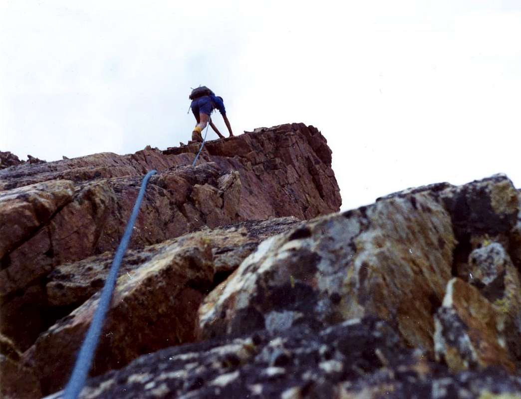
From Laures Pass (3.305m) turn in left (S) and, by grassy slope amongst boulders or snowfields, at E Crest base, near rocks in the shape of great boulders, dark and alternate with reddish plates; turn straight away in left (South; I°+), also face by various climbing and quite possibility (II°, even more, wishing). Reach like this a series of three inclined in right (East) boulder and to cross (II°+/III°-), also to go beyond by a narrow and small grassy gully still same side, reaching on little and round prominence, formed by rotten greyish blocks. Go up easily and linearly in edge always a more jagged part, where from the rocks assumed ruddy appearance, waving various vault in grey/greenish; join this way while the crest more upsurge, with decisively red rock. Climb in edge (even III°+) also move in right North and, by a ledges series with soil and dark rotten rocks (subject to landslides; I°+/II°-, but delicate and in North-northeast exposed), or overcome in edge a half grey and half red gendarme, about 7/8 meters (in this case III°+), and reach in NE a small shoulder in the shape of dangling balcony and, very soon, without difficulty, the Summit, with vertex in East (EE/A; F+/PD-/PD+, on conformity of chosen difficult; 1h'30/2h'15 from pass, same remarks).
IN DESCENT: Same route also (by crossing of two rocky pinnacle; more good and amusing) go down by NW Ridge. Before by a linear route with some indented in terminal part, after abrupt to descend to a first "carving" in the shape of large V (II°/II°+; 20/25m); go up a first squared tower, with vertex in East (I°+/II°-). Cross before through easy descent, after by a brief but steep wall (II°+; turned in Northeast by a small ledge) and reach a second, always in V, not as much narrow brèche. Overcome a second round tower less stately (II°+/III°- in edge; even turned in Northeast by a narrow ledge) and go down to small Saddle 3.250m~, after cross a pinnacles series among what two interesting (in the shape of reddish and brown towers) and amusing (II°/II°+, in edge also through a small ledge/balcony in North). From this climbing, by S-SE Ridge with enough solid rock (I°+/II°/II°+; 150 metres) in the shape of red plates to of Emilius Red Eastern Point (3.399m). Descend by NE Ridge and to win back the Arbolle Pass (3.154m; a delicate exposed in Northwest passage on middle crest, rock very broken reason; to pay attention to numerous a group of rope climbers extant, for rocks falls bringing about passages). Besides, for more willing and more training mountaineers, a second possibility extant: from of Emilius Red Point Eastern Summit cross towards Central (3.395m~) and Western; from this descend easily, by a S-SW Crest, to Valaisan Pass (3.210m) and with East direction go down on and between Lussert Four Lake/Higher Lake reaching again the Laures Pass (3.035m) and "closing" a splendid link of a chain (PD-/PD+; 1h'15 from Laures Point to Emilius Reds Point Eastern Summit; 8h'00/9h'00 from Station and by NE Ridge descent from Eastern Red Point; 11h'30/12h'30 from Pila and entire tour through Valaisan Pass Eastwards descent).
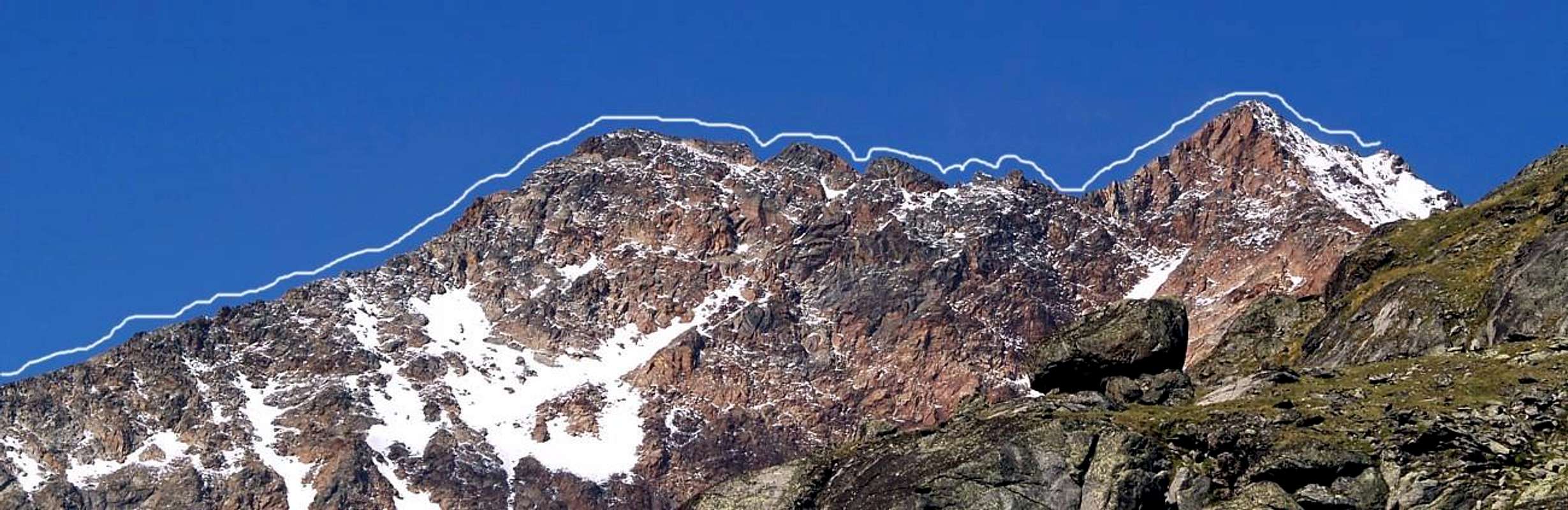
Dal Col des Laures (3.036 m) volgere a sinistra (S) portandosi, con breve risalita su pendio erboso tra blocchi sparsi o nevai, ad W alla base della Cresta E, presso rocce a grandi blocchi e scure alternate a placche rossicce; aggirarle subito a sinistra (S; I°+), oppure affrontarle con arrampicata varia e diverse possibilità (III° ed anche, volendo, di più). Raggiungere così una serie di tre roccioni inclinati a destra (E) ed attraversarli (II°+/III°-) oppure oltrepassarli per uno stretto canalino erboso sempre dalla stessa parte (S), pervenendo ad un piccolo promontorio rotondeggiante formato da blocchi rotti e grigiastri. Risalire facilmente e linearmente sull'orlo sino ad un tratto più frastagliato, ove le rocce assumono aspetto rossastro, alternandosi varie volte a grigio/verdastre. Giungere così laddove la cresta si impenna maggiormente, aumentando notevolmente in ripidezza, e la roccia diventa decisamente di color rosso. Arrampicare in cresta (volendo, anche III°+), vincendo sul filo un gendarme mezzo grigio e mezzo rosso di 7/8 m~; oppure spostarsi a destra e salire per una serie di cengie con terriccio, rocce scure, rotte, con ghiaie e terriccio e possibilmente franose con difficoltà di I°+/II°-, ma con salita delicata ed esposta a N-NE. Pervenire infine ad una piccola spalla/balcone "penzolante" a NE e, subito dopo senza difficoltà, alla Cima, posta sul vertice E (EE/A; F+/PD-/PD+, a seconda dell'itinerario scelto; 1h'30/2h'15 dal colle, con le stesse considerazioni).
DISCESA: Per la stessa via, oppure (più bello e divertente) scendere tramite la Cresta NW; dopo un facile percorso quasi lineare con qualche dentellatura nel finale, scendere bruscamente ad un primo intaglio a forma di V allargata (II°/II°+; 20/25 metri). Risalire agevolmente ad un primo torrione squadrato con vertice a E (I°+) e, dopo averlo attraversato (I°+/II°-, sul filo; anche aggirabile sulla destra (NE) per una stretta cengia), raggiungere una seconda brèche, sempre a V ma più stretta, con un passaggio ripido (II°+). Superare il successivo tondeggiante torrione di più ridotte dimensioni (II°+/III°-, sul filo; aggirabile a N per stretta cengia) e scendere facilmente larga alla Sella 3.250 m~, dopo aver attraversato una serie di pinnacoli dei quali due interessanti (forma di torri rossicce e brune), nonché divertenti nel salirli (II°/II°+, sul filo oppure su cengia a N). Dalla sella salire alla Punta Orientale della Punta Rossa dell'Emilius (3.339 m) con la Cresta S-SE (I°+/II°/II°+; 150 metri; roccia rossa a placche abbastanza buona); scendere riguadagnando il Colle d'Arbolle (3.154 m) tramite la Cresta NE (I°+/II°-; 245 m; un passaggio delicato a metà percorso con esposizione a NW, causa la roccia molto rotta; prestare attenzione, in presenza di più cordate, alla caduta di pietre). Inoltre, per i più volenterosi ed allenati, esiste la possibilità di attraversare le tre vette della Punta Rossa dell'Emilius (3.399 m, 3.395 m~, 3.401 m), scendere facilmente con la Cresta S-SW al Pas du Valaisan (3.210 m) e da questi, con direzione E, raggiungere i Laghi del Lussert tra il Lago Alto ed il Lago Superiore ed attraversare al Col des Laures, "chiudendo" uno splendido anello (PD-/PD+; 1h'15 dalla Punta di Laures alla Punta Rossa Est; 8h'00/9h'00 dalla Stazione d'arrivo della Seggiovia di Chamolé con discesa tramite la Cresta NE; 11h'30/12h'30 da Pila per l'intero giro con discesa ad oriente dal Pas du Valaisan).
Gear
High mountain gear.L'itinerario è classificato PD+.
 |
 |
 |
 |
 |
Campings
Remember that free camping is forbidden (except for emergency reasons, over 2.500m, from darkness until dawn).Mountain Condition
- Meteo: you can find all the needed informations at the official site of the Valle d'Aosta Region:
- Valle d'Aosta Meteo
Webcam
- WEBCAM on Aosta Valley:
- Webcam
Books and Maps
BOOKS:- "Guida delle Alpi Occidentali", di Giovanni Bobba e Luigi Vaccarone C.A.I. Sezione di Torino Volume II (parte II), 25 Maggio 1896.
- "80 itinerari di Escursionismo Alpinismo e Sci Alpinismo in Valle d'Aosta", di Osvaldo Cardellina, Ed. Musumeci, Giugno 1977 (in Italian); seconda Ed. Luglio 1981; terza Ed. Luglio 1984; (in French), prima Ed. Febbraio 1978; seconda Ed. Marzo 1980.
- "Guida del Monte Emilius", di Osvaldo Cardellina Editore in collaborazione con il Club Alpino Italiano Sezione di Aosta, Dicembre 1978 (in Italian).
- "Rifugi e bivacchi in Valle d'Aosta", di Cosimo Zappelli aggiornata da Pietro Giglio, Musumeci Editore, Luglio 2002.
- "Guida dei Monti d'Italia–Emilius Rosa dei Banchi Parco del Mont Avic", di Giulio Berutto e Lino Fornelli - Club Alpino Italiano/Touring Club Italiano, Marzo 2005 (in Italian).
- "Ascensioni 1964-1969" Diario Alpinistico di Ilario Antonio Garzotto (unpublished).
- "Diari Alpinistici", di Osvaldo Cardellina e Indice Generale accompagnato da Schedario Relazioni Ascensioni 1964-2019 (unpublished).
 |
 |
 |
 |
MAPS:
- Kompass "Gran Paradiso Valle d'Aosta Sentieri e Rifugi" Carta Turistica 1:50.000.
- Hapax Luglio 2000 "Les Sentiers" Comunità Montana Monte Emilius 1:25,000.
- L'Escursionista "Conca di Aosta-Pila-Monte Emilius" Carta dei sentieri (n° 4) 1:25.000.
- L'Escursionista "Valle di Cogne Carta dei Sentieri" (n°10) 1:25.000.
- Enrico Editore Ivrea-Aosta "Gruppo del Gran Paradiso" 1:50.000.
- I.G.C. Istituto Geografico Centrale Torino "Carta delle Passeggiate ed Escursioni in V.D.A. Conca di Pila-Gressan" 1:20.000.
Important Information
- REGIONE AUTONOMA VALLE D'AOSTA the official site.
- FONDAZIONE MONTAGNA SICURA Villa Cameron, località Villard de la Palud n° 1 Courmayeur (AO) Tel: 39 0165 897602 - Fax: 39 0165 897647.
- SOCIETA' GUIDE ALPINE DI COGNE Tel. 347/9473526 – 328/1373728.
- A.I.NE.VA. (Associazione Interregionale Neve e Valanghe).
- A.IA.T. Cogne Gran Paradis via Bourgeois n° 34 Tel. 0165-74040. E-mail: aiat@cogne.org
- Ezio Sport articoli sportivi - via Bourgeois n° 64 Tel. 0165-74204.
Useful numbers
- Soccorso Alpino Cogne (SAR) Tel. 3482685406.
- Protezione Civile Valdostana località Aeroporto n° 7/A Saint Christophe (Ao) Tel. 0165-238222.
- Bollettino Meteo (weather info) Tel. 0165-44113.
- Unità Operativa di Soccorso Sanitario Tel. 118.
Acknowledgements
I am greatly indebted to my friend "Osva" for the detailed description of the route.