


-
 3076 Hits
-
 81.84% Score
-
 14 Votes
|
|
Mountain/Rock |
|---|---|
|
|
45.64420°N / 7.36790°E |
|
|
Mountaineering, Trad Climbing |
|
|
Spring, Summer, Fall, Winter |
|
|
10600 ft / 3231 m |
|
|
Note
|
La montagna chiama i suoi figli, ed essi rispondono fedelmente al suo appello… Osvaldo Cardellina, Diario alpinistico, 1964-65 Page texts: @ OsvaldoCardellina "Osva", passed away on May 2, 2022. Page owners: Christian Cardellina e Osvaldo Cardellina. Any updates from September 12, 2022: Antonio Giani, page administrator, friend and climbing companion. Testi della pagina: @ OsvaldoCardellina "Osva", scomparso il 2 maggio 2022. Proprietari pagina: Christian Cardellina e Osvaldo Cardellina. Eventuali aggiornamenti dal 12 settembre 2022: Antonio Giani, amministratore della pagina, amico e compagno di salite. |
Sharp & Cut Overview
This three Summits is part of the Group of Mount Emilius (3.559m), located between the Walloons Grauson to the East and Arpisson in opposite side, above Gimillian Hamlet (1.787m) in Cogne Valley. In fact this Summit is made up of three distinct elevations placed on axis South-southwest/North-northeast, or between the Colle di Pila Southwest (about 3.028 meters) and the Northeast (3.090 meters). The first or the Southwest turns out to be the highest (3.231m); follows a Central Vertex few feet lower (about 3.220 meters), while the third, or the Northeast, is of another 5/6 meters lower. Always the first is separated from the other two by a saddle wider, while between the two successive fits a net carving. Over the watershed declines on another altitude (3.187m) in the form of large balcony notched, before a second "flatter" (3.170m) to finally then down on the hill of the Northeast. His two sides appear wild and precipitous. What Western is crossed by two large rocky channel that isolate the most Southwestern Summit; the first partition reaches an elevation between the square and the Southwest Ridge Top; the other separates this from the other two Summits. Overall height slopes down from 450 meters to 320 meters in the most in the North. Composed of steep rocks and marches are very exposed to falling rocks and, at time, we have seen that most of the discharges of small landslides on the slopes facing Northwest. Interesting and quite difficult to climb the Great Rib in the middle of the South West and triangular wall by Southwest Top; however, also apply here considerations above. The Eastern Slope is instead made up of a series of small grassy-rocky walls alternating with various couloirs up to what the Colle Northeast drops steeply to about 1.000 meters above the Alp Pila in the wide Valley of Grauson. In the stretch instead just below the three Summit height varies from 250 to 350 meters above the Lavà Coste, between Tsaplana (2.681m) and the large channel above. In any case, this side is to be avoided, as treacherous and dangerous thing for which the only way it is advisable that the ridge starting from Punta Arpisson (3.035m) and the nearby Hill of Pila Southwest. However, in addition to the Group of Emilius, this Summit belongs specifically to Subgroup of Punta Garin (3.451m, 3.448m in Old Maps); this last five branches off ridges in different directions. What interests us is the Buttress South-southwest that, taking origin directly from the Top of the Peak, falls separating the Vallons Arpisson West from that much larger of Grauson on the opposite side. The Southern Crest it "breaks" its linearity to a notch, called "the Carving of Garin" (3.285m), from which continues gradually bending slightly to the West and forming a series of Summits with no great difference in elevation between the same; reached Punta Arpisson and its Ante Top Southern (3.035m, 3.028m) is split: a branch in the same direction until the "Cornass of the Arpisson" (2.751m, 2.607m), just above a small saddle 2.317 meters which allows the connection between these two valleys. A second branch is directed towards Southeast reaching the promontory of Tsaplana (2.681m), beyond which is dispersed over the ancient and now abandoned pastures Alp Perché, above a small forest that reaches Gru Torrent in "Lower" Walloon of the Grauson. Starting from the "Carving of Garin" and procededendo along the axis North/South we have the following relative elevations and depressions: Punta Fleurie or Fiorito (3.258/61m), three Bits of Lavà (3.214m), Fleurie or Colle Fiorito (about 3.170/80m), Tower Arpisson (3.227/31m), Col Pila Northeast (3.090m), three Pointes Coupées of Arpisson (3.215/18m, 3.220/4m, 3.231m), Col Pila Southwest (3.028m) and finally Punta Arpisson (3.035m), whence to what has been stated above. Regarding altitudes are considered primarily to those of the Charter of 25.000 by I.G.M. and, in cases of discrepancy, listed alongside those of maps, always the same scale, type "L'Escursionista" (The Hiker); in the event of a total lack of feedback gets reference to personal observations made during the climbs. These Summit are found throughout the Cartography of the past as "Punte Coppi", except that in the recent 2001 Paper "GRAN PARADISO Cogne - Valsavarenche MAP", always Scale 1:25.000, by Cogne and Valsavarenche Municipalities, where the name is brought back to the right end (on sale at the two respective "Pro Loco", 2 Euro). But about that present a research-study in a dissertation now to follow.
 |
Questa triplice Sommità fà parte del Gruppo del Monte Emilius (3.559 m), posto tra i Valloni del Grauson ad Oriente e dell'Arpisson sul lato opposto, al di sopra del Villaggio di Gimillan (1.787 m) in Val di Cogne. In realtà questa Sommità é formata da tre ben distinte elevazioni poste sull'asse Sud-sudovest/Nord-nordest, ovvero tra il Colle di Pila Sudovest (3.028 metri circa) e quello Nordest (3.090 metri circa). La prima o Sudovest risulta essere la più elevata (3.231 m); segue una Punta Centrale di qualche metro più bassa (3.220 metri circa), mentre la terza, o Nordest, é di altri 5/6 metri inferiore. Sempre la prima é separata dalle altre due da una sella più larga, mentre tra le due successive si inserisce un netto intaglio. oltre lo spartiacque declina su d'un altra altitudine di (3.187 m) a guisa di grande balcone dentellato, prima di un secondo "più piatto" (3.170 m) per infine scendere sopra il Colle di Nordest. I suoi due lati si presentano selvaggi e dirupati. Quello Occidentale é solcato da due canaloni rocciosi isolanti maggiormente la Sommità Sudovest; il primo raggiunge il divisorio tra un elevazione squadrata della Cresta Sudovest e la Vetta; l'altro separa nettamente questa dall'altre due Cime. Complessivamente l'altezza digrada da 450 metri a 320 metri nel tratto più Settentrionale. Composti da rocce ripide e marce son molto esposti alla caduta di pietre e, in occasione di temporali, abbiam visto più che delle scariche delle piccole frane sul versante rivolto a Nordovest. Interessante ed abbastanza difficile la scalata del Costolone Ovest in mezzo alla triangolare Parete Ovest della Punta Sudovest; però anche qui valgon le considerazioni di cui sopra. Il Versante Orientale é invece costituito da una serie di piccole pareti erboso-rocciose alternate a vari canaloni fino a quello che dal Colle Nordest scende ripido per circa 1.000 metri sopra l'Alpe Pila nell'amplio Vallone del Grauson. Nel tratto invece subito sotto le tre Sommità l'altezza varia da 250 a 350 metri sopra le Coste di Lavà, tra la Tsaplana (2.681 m) ed il grande canale sopra citato. Queste coste sono costituite da vasti e ripidi pendii erbosi, nei tempi passati sfruttati pel pascolo ed attraversate da un sentierino che le "taglia" nel lor mezzo salendo tra grandi banconate rocciose, nel primo tratto oltre l'Alpe Pila, per poi proseguire a metà strada tra il fondo delle pareti erboso-rocciose ed il sottostante torrente che in questo tratto da Lussert, riunificando anche le acque di quelli di Corona, Doreire e Money, prende nome di Gru (Grosso). In ogni caso anche questo versante é da evitarsi, poichè infido e pericoloso per la quale cosa l'unica via consigliabile risulta quella in cresta partendo dalla Punta di Arpisson (3.035 m) e dal vicino Colle di Pila Sudovest. Però, oltre che al Gruppo dello Emilius, questa Sommità appartiene più specificamente al Sottogruppo della Punta Garin (3.451 m; 3.448 m nelle Vecchie Carte); questa ultima dirama cinque creste in diverse direzioni. Quella che a noi interessa é il Contrafforte Sud-sudovest che, prendendo origine direttamente dalla Sommità del Picco, scende separando i Valloni di Arpisson ad Ovest da quello ben più vasto del Grauson sul lato opposto. La Cresta Sud della medesima "infrange" la sua linearità ad un intaglio, detto Intaglio della Garin (3.285 m), dal quale continua piegando progressivamente di poco verso Occidente e formando una serie di Sommità con non grande differenza di elevazione tra le medesime; raggiunta la Punta di Arpisson e la sua Antecima Meridionale (3.035 m, 3.028 m) si sdoppia: un ramo procede nella stessa direzione fino ai "Cornass dell'Arpisson" (2.751 m, 2.607 m), appena al di sopra d'una selletta 2.317 metri permettente il collegamento tra i due suddetti valloni. Un secondo ramo s'indirizza verso Sudest raggiungendo il promontorio della Tsaplana (2.681 m), oltre il quale si disperde sopra gli antichi ed ormai abbandonati pascoli dell'Alpe Perché, al di sopra d'una piccola foresta raggiungente il Torrent Gru nel "Basso" Vallone del Grauson. Partendo dallo "Intaglio della Garin" e procededendo lungo lo asse Nord/Sud avremo le seguenti elevazioni e relative depressioni: Punta Fleurie o Fiorito (3.258/61 m), tre Punte di Lavà (3.214 m), Colle Fleurie o Fiorito (3.170 m), Torre di Arpisson (3.227/31 m), Col di Pila Nordest (3.090 metri circa), tre Pointes Coupèes d'Arpisson (3.215/18 m, 3.220/4 m, 3.231 m), Col di Pila Sudovest (3.028 m) ed infine Punta di Arpisson (3.035 m), donde a quanto testé detto sopra. Per quanto concerne le altitudini vengono prese in considerazione "in primis" quelle della Carta al 25.000 dello I.G.M. e, in caso di discordanza, elencate a fianco quelle di Carte, sempre stessa Scala, tipo L'Escursionista; in caso di mancanza totale di valutazioni si fà riferimento ad osservazioni personali effettuate durante salite. Queste Sommità si ritrovano in tutta la Cartografia passata come "Punte Coppi", tranne che nella recente Carta dei Comuni di Cogne e Valsavarenche, dove il toponimo viene ricondotto a giusto termine. Ma a tal proposito presentiamo una ricerca-studio in una dissertazione subito a seguire.
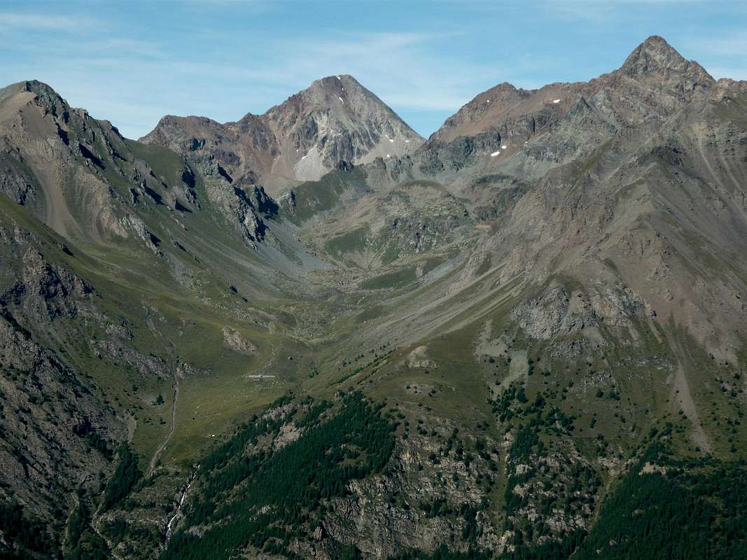
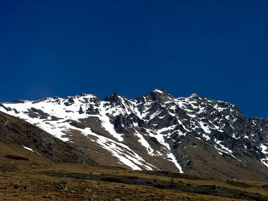
Punta Rossa, Mont Valaisan, Pic Garin, Punta Fleurie, Arpisson Tower, Pila NE Pass & three Pointes Coupées d'Arpisson from West, by emilius
![]()
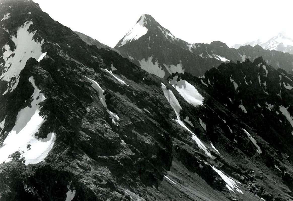
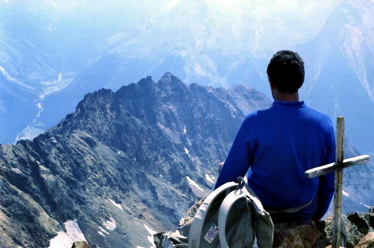
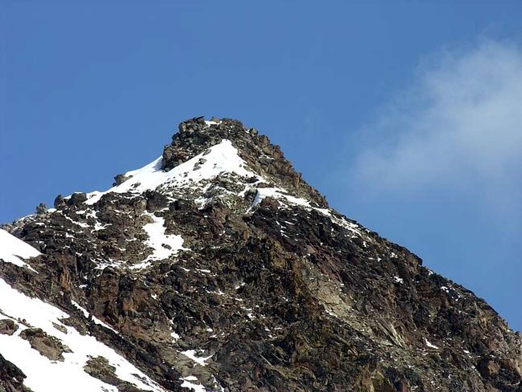
In background: Peak Garin with (to the right) S-SW Buttress from "Becca" or Northwest, by Osw
![]()
From Punta di Arpisson & Pila Southwestern Pass at the beginning of the traverse, by Osw
![]()
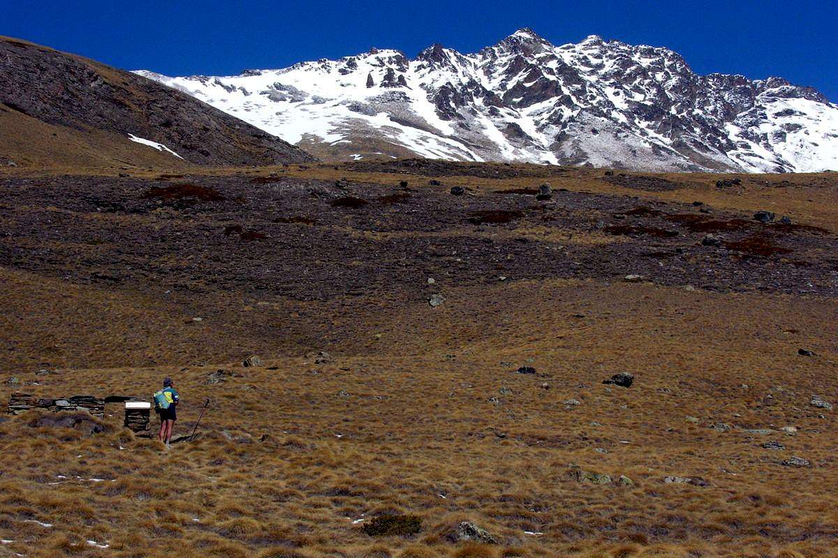
Approaching from Gimillan amongst ibexes, by OliettiPaolo
![]()
Traversing on middle part nearby Perché Alp, by emilius
![]()
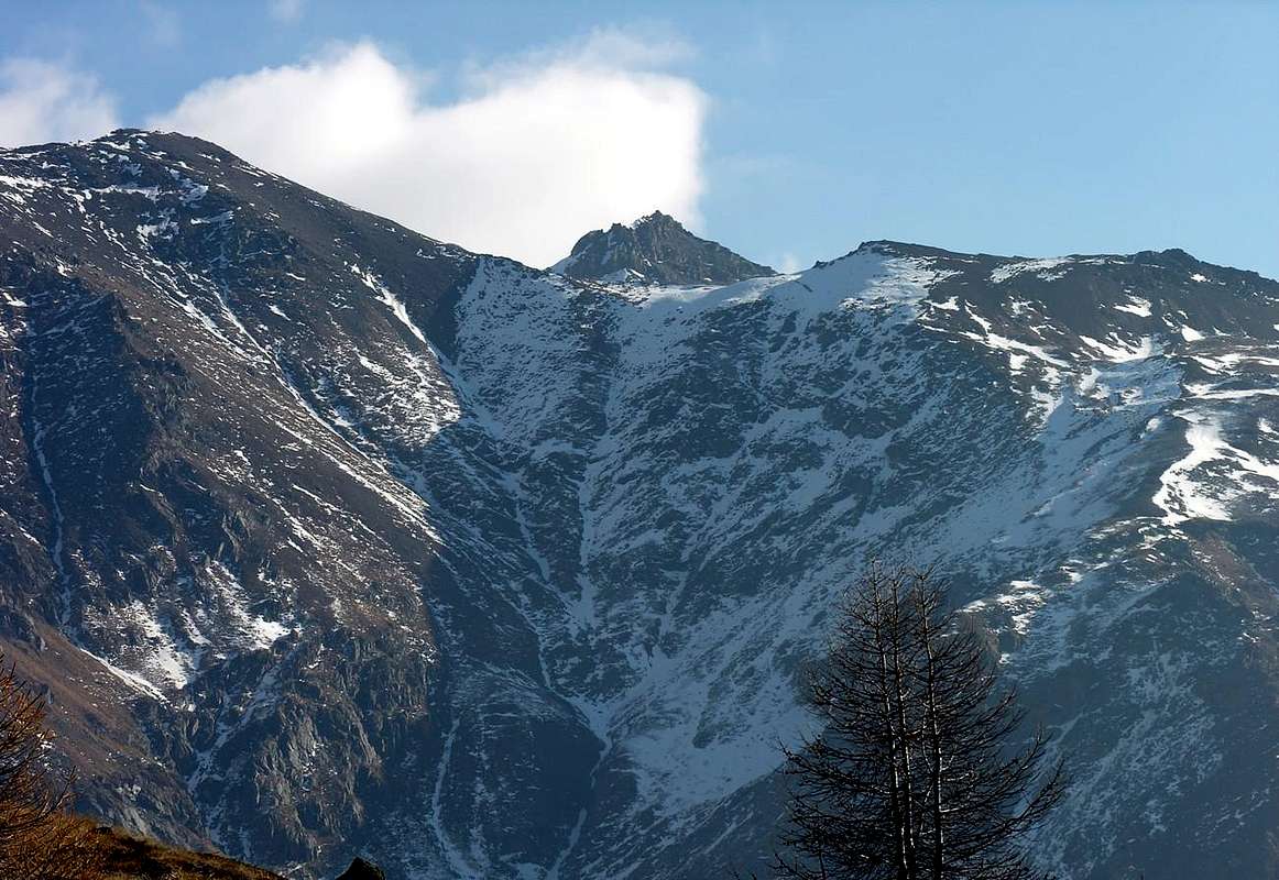
Ascending in the middle-high part to Tsaplana, by Antonio
![]()
Arriving from Epinel (left) or Gimillan, by Lupino
Neighbor the fork about 1.970/80 meters by Gimillan & the midst-part of the Arpisson Vallon towards of Pian di Bessey, by livioz
![]()
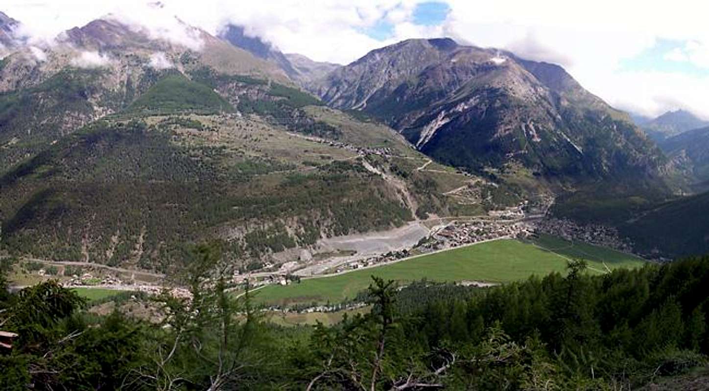
Cogne Resort with above Gimillan Village, by livioz
![]()
At the beginning of SW Crest from Pila SW Pass, by emilius
![]()
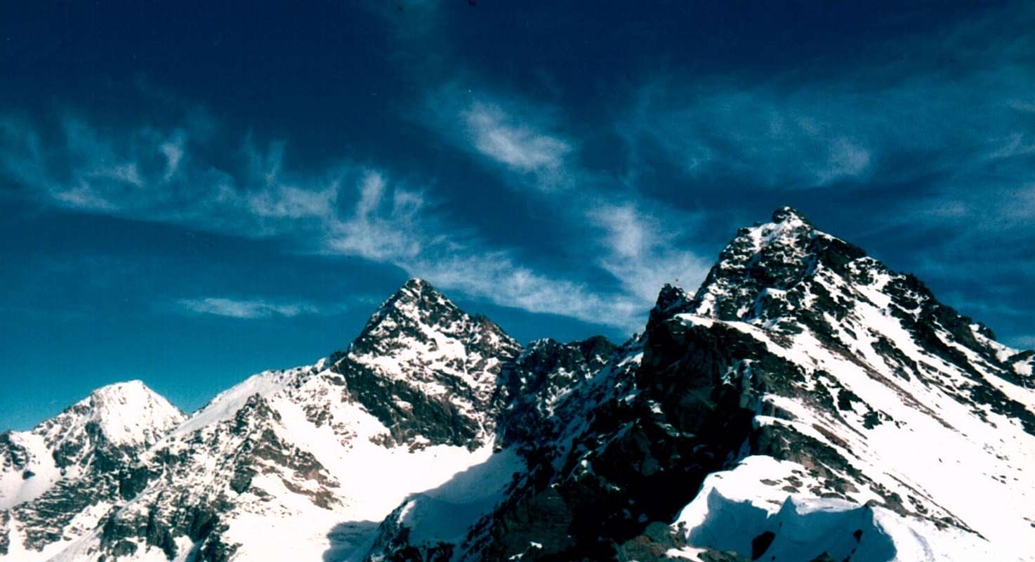
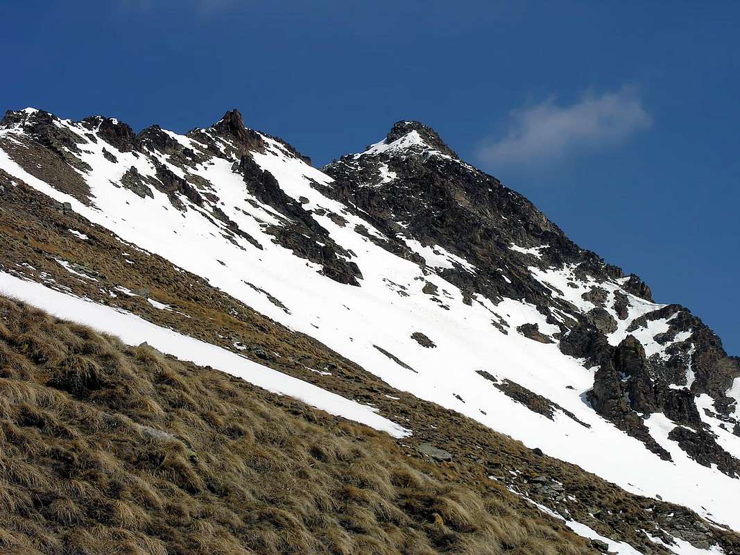
The SW & NE Ridges climbing towards Pic Garin, by Osw
![]()
S-SW Buttress from Garin, by Camillo Roberto Ferronato
 |
 |
 |
 |
 |
Small Research Historical-Toponomastic
This triple Mountain is referred to as Punte Coppi in all the Old Maps. At least in the after-cards ""Group of Gran Paradiso"", Scale 1:50.000, published in 1908 by I.G.M., according to the findings of the Engineer Paganini and under the aegis of the Sections of Turin and Aosta. The same was inserted to the Bulletin XXXIX° with the generic abbreviation for "Charter of C.A.I.". Happened to the "Charter Sardinian 1856-58" as the same Bulletin 1908, n° 72. However in a large color paper in 1878 or 1988 (?), I have, in this coastal existed, from the bottom, only these names: Cornas dell'Arpisson (2.340m), T. Châplane (2.673m), P. d'Arpisson S. (+ 2.823m) and unnamed, but granted as opposed to the North Altitude (3.033m), easily attributable to the current and with evidence of the presence of a Cross on Antetop South, however, listed or too defect or corresponding to a lower, than the current, altitude on the Southwest Ridge. The next stretch, that is what the Pila Southwest bypasses the three Pointes Coupées to reach the Pila Northeast Pass shows only the generic name of P. Vachères and Col de Pila for the second of the two, without giving both a height; in fact a Comba Vachère still exists today at the foot of the Southern Slope of the Tsaplana and between the two Torrents de Gimillan and Tarambel. Following the massive Tower Arpisson is not even reported as name and height as well as the graphical representation is unsatisfactory; perhaps, we say, because Gimillan not see her, and certainly in those days did not care a lot for if it is true that has been rising "downhill" from Garin Peak from roped English Compton-Richards with Guides Swiss Alois and Siegfried Burgener in 1897, preceded by just seven days by George Yield with his Guide Valtournanche François Pession, in ascent August 13th. Disappears Col Fleurie, as by positioning the Map, and it seems most quoted indicate the Col de Pila and you have to get to the P. Fiorita (3.252m), here rightly feminine as named by the underlying Combe de la Chaz Fleurie; the last stretch, properly drawn South, leading to P. Garin (3.447m). After all this analysis, the Mystery has not been solved; we only know that the Tips were generically Vachères, but the snag of this Punta Coppi is still not addressed and much less solved. We must continue the "path mapping" and get to the I.G.M. campaign raised cartographic, with 25.000 tablets, of 1930 to 1932 and 1973 to begin to understand something. The Cartographer era, certainly questioning the farmer-herder Gimillan, you will be heard responding: "Les Pointes Coupì", doubling, as the local dialect, is the pe then "Pointes Couppì", whence, by the ear is not accustomed to the language, in a short time to "Tips Coppi". Nor can one speak of a dedication to the famous Italian cyclist Fausto Coppi, which in those days he was 11 or 13 years (it was 1919). Same goes for Garin that there is a dedication to the cyclist of Aosta Valley Arvier Maurice Garin won the first Tour de France, but it seems that comes from the top or Gar. But we will discuss later. We must instead wait until December 1978 when in "Guide of Monte Emilius" is pointed out the glaring error on page 94 where it says: "The more easily spot the place name was, incidentally as the appearance of the tips suggests and how well it is supported by analogies to Val de Cogne, be to Pointes Coupì or Coupées, also "Tips Cut"; seems so much more sense to bring the name of fairness on the tracks matching the same, if anything, with that "Arpisson" specification to distinguish themselves from other Coupé existing in the same valley". See Pointe Coupée in close Group of Penne Blanche and various Coupé in against Valnontey. Thus, and with pleasure, it has been able to in the new Cart "Gran Paradiso Cogne etc. MAP" to 25.000 in 2011, has accepted the correct name of "Pointe Coupée". In itself, however, are "touched up" with 3.168 meters for the same, 3.140m to Col Pila Northeast, 3.227m to the Tower of Arpisson, 3.197m to the Fiorito Pass, here in the masculine, and 3.218m to the nearby Tips Lavà; Punta Fiorito 3.260m and 3.461m even for the Vertex Peak Garin. An assessment with which I fully agree, as various empirical analyzes performed, because almost certainly derived from satellite measurements. As for the name of Garin instead, notwithstanding the assumption in "Who knows why they call it A Crack in the vocabulary of the mountains of Aosta Valley" C.A.I. Aosta Valley with texts by Umberto Pelazza and by Marica Forcellini, Edit. 2011, states on page 132: "They return the names of the sons rocks: Gar in Punta Garin; ...". Undoubted talents place names which the Author of a very good Pelazza, we would like to observe, however, without the will claim to have hit the mark, that perhaps this is a definition too "noble" for what was probably the only limitation of an old farmhouse, confirmed by the "Low Garin" indicating the transition to the concomitant Upper Alpage Arbolle on the routes for Comboé and Pila. Waiting for serious research in municipal offices or parishes, of this Pelazza remains however the only real plausible hypothesis, while my remains, until proven otherwise, only a simple observation. More in over 200 years of Mountaineering History we never found, even at the tutelary deity corresponding to Abbé Joseph Maria Henry. For other names Arpisson comes from arp, ie Alp and some other type Côtes Lavà (steep grassy coasts and "washed out"), was assigned by the work of 1978 and now accepted in the Charter of 2011 Cogne-Valsavarenche. Is generally directed to a location below: for example, over Lavà, Bessey, Tsavanis, Tsa Setze, Lussert etc .; while remaining inside Group Monte Emilius.
Questa triplice Sommità vien denominata come Punte Coppi in tutte le Vecchie Mappe. Almeno in quelle successive alla Carte "Gruppo del Gran Paradiso", scala 1:50.000, pubblicata nel 1908 dallo I.G.M., in base ai rilievi dell'Ingegner Paganini e sotto l'egida delle Sezioni di Torino ed Aosta. La medesima veniva inserita al Bollettino XXXIX° con la generica abbreviazione di "Carta del C.A.I.". Succedeva alla "Carta Sarda 1856-58" come da medesimo Bollettino 1908, n. 72. Comunque in una grande carta a colori del 1878 o 1988 (?), in mio possesso, in questa costiera esistevano, partendo dal basso, solo questi toponimi: Cornas dell'Arpisson (2.340 m), T. Châplane (2.673 m), P. d'Arpisson Sud (+ 2.823 m) e senza nome, ma scontato per contrapposizione Nord la Quota (3.033 m), facilmente riconducibili all'attuali e con testimonianza della presenza d'una Croce sull'Antecima Sud, peraltro o quotata troppo in difetto o corrispondente ad una quota inferiore, rispetto all'odierna, sulla Cresta Sudovest. Il tratto successivo, cioé quello che dal Col di Pila Sudovest scavalca le tre Pointes Coupées per raggiungere quello di Nordest riporta esclusivamente il toponimo generico di P. Vachères e Col de Pila per il secondo dei due, senza dar ad entrambi un'altezza; in effetti una Comba Vachère esiste ancora oggigiorno ai piedi del Versante Meridionale della Tsaplana, compresa tra i due Torrents de Gimillan e di Tarambel. A seguire la poderosa Torre di Arpisson non vien neppur segnalata sia di nome che d'altezza ed anche la rappresentazione grafica lascia a desiderare; forse, diciamo noi, perché da Gimillan non la si vede e certamente a quei tempi non interessava un gran ché, se é vero che é stata salita "in discesa" dalla Garin dalle cordata inglese Compton-Richards con le Guide svizzere Alois e Siegfried Burgener nel 1897, preceduta di soli sette giorni da George Yeld con la sua Guida di Valtournanche François Pession, in salita il 13 di Agosto. Scompare il Col Fleurie che, come da posizionamento sulla Carta, pare più indicar il citato Col de Pila e bisogna arrivare alla P. Fiorita (3.252 m), qui giustamente al femminile poiché porta il nome dalla sottostante Combe de la Chaz Fleurie; l'ultimo tratto, correttamente disegnato a Sud, conduce alla P. Garin (3.447 m). Dopo tutta quest'analisi, il Mistero non é stato risolto; sappiamo soltanto che genericamente erano le Punte Vachères, ma il busillis di questa Punta Coppi non viene ancora affrontato e men che meno risolto. Bisogna proseguire il "cammino cartografico" ed arrivare alle levate di campagna I.G.M., con tavolette al 25.000, del 1930-1932 e 1973 per iniziare a comprendere qualcosa. Il Cartografo dell'epoca, sicuramente interrogando il contadino-pastore di Gimillan, si sarà sentito rispondere: "Les Pointes Coupì", raddoppiando, come é nel dialetto locale, la p e quindi "Pointes Couppì", donde, per un orecchio non assuefatto all'idioma, in breve tempo a "Punte Coppi". Neppur si può parlar d'una dedica al famoso ciclista italiano Fausto Coppi, che a quei tempi aveva 11 o 13 anni (era del 1919). Stesso discorso vale per Garin che non é una dedica al ciclista valdostano d'Arvier Maurice Garin vincitore del primo Tour de France, ma par derivi da Gar ossia Sommità. Ma di questo discuteremo più avanti. Bisogna invece attendere Dicembre 1978 quando in "Guida del Monte Emilius" vien fatto notare il madornale errore, ove a pagina 94 si dice: "Più facilmente in loco il toponimo doveva, come daltronde l'aspetto delle punte induce a pensare e come pure é sostenuto da analogie per la Val di Cogne, essere quello di Pointes Coupì o Coupées, ovverossia Punte Tagliate; pare quindi alquanto più sensato ricondurre il toponimo sui binari della correttezza abbinandolo, semmai, con quel "di Arpisson" di specificazione per distinguerle da altri Coupé esistenti nella stessa vallata". Vedi Pointe Coupée nel vicino Gruppo del Penne Blanche ed i vari Coupè nella dirimpettaia Valnontey. Così, e con piacere, si é potuto che nella nuova Carta "Gran Paradiso Cogne ecc. MAP" al 25.000 del 2011 si é accettato il corretto toponimo di "Punta Coupée". Nella stessa vengono però "ritoccate" con 3.168 metri per la medesima, 3.140 m per il Col di Pila Nordest, 3.227 m per la Torre di Arpisson, 3.197 m per il Colle Fiorito, qui al maschile, e 3.218 m per le vicine Punte di Lavà; la Punta Fiorito 3.260 m ed addirittura 3.461 m per il vertice massimo della Punta Garin. Una valutazione che mi trova completamente daccordo, come da varie analisi empiriche effettuate, anche perché quasi certamente deriva da misurazione satellitare. Per quanto concerne il toponimo di Garin invece, nonostante quanto presupposto in "Chissà perché si chiama così A spasso nel vocabolario dei monti valdostani" del C.A.I. Valle di Aosta con testi di Umberto Pelazza ed a cura di Marica Forcellini, Edit. 2011, si legge a pagina 132: "Ritornano i toponimi figli delle rocce: Gar nella Punta Garin; ...". Indiscusse le doti toponomastiche d'un Autore quale il bravissimo Pelazza, ci permettiam però d'osservare, senza voler pretendere d'avere colto nel segno, che forse è questa una definizione troppo "nobile" per quella che probabilmente era soltanto la limitazione d'un antico podere, confermata anche da quel "Bassa di Garin" indicante il passaggio verso il concomitante Alto Alpeggio di Arbolle sulle vie per Comboé e Pila. In attesa di serie ricerche nelle sedi comunali o nelle parrocchie, questa del Pelazza rimane però l'unica vera ipotesi plausibile, mentre la mia rimane, fino a prova contraria, esclusivamente semplice osservazione. Altro in oltre 200 anni di Storia Alpinistica non abbiamo mai trovato, nemmeno presso quel Nume tutelare che corrisponde all'Abbé Joseph Maria Henry. Per gli altri toponimi Arpisson deriva da arp, cioé Alpe e qualche altro, tipo Côtes Lavà (ripide coste erbose e "slavate"), é stato assegnato dall'opera del 1978 ed ora accettato nella Carta 2011 di Cogne-Valsavarenche. Generalmente é rivolto ad una località sottostante: ad esempio, oltre Lavà, Bessey, Tsavanis, Tsa Setze, Lussert ecc.; sempre restando all'interno del Gruppo del Monte Emilius.
First Ascents
- First on the Summit: Osvaldo Cardellina and Giuseppe Lamazzi; Jan 08th, 1978, in ascent by Southwest Crest and traverse to Pila NE Pass.
- In winter: Osvaldo Cardellina and Giuseppe Lamazzi; Jan 08th, 1978, with descent from NE Pass by Eastern Couloir to Pila Alp in Grauson Vallon.
- South-southwest Ridge: Osvaldo Cardellina and Giuseppe Lamazzi; Jan 08th, 1978, in ascent by Tsaplana to Pila SW Hill and traverse to Pila NE Pass.
- West Wall (Western Rib of Southwestern Top): Osvaldo Cardellina, lone; May 15th, 2008, from Gimillan, Arpisson, Pian di Bessey middle Tableland.
- Northwest Face (Northwest Face of Southwestern Summit): Osvaldo Cardellina, lone; May 11th, 2008, from Gimillan, Arpisson, Pian di Bessey.
- North-northeast Crest: Osvaldo Cardellina and Giuseppe Lamazzi; Jan 08th, 1978, in descent from Northeast Summit to Pila NE Pass.
- Great traverse (Punta di Arpisson, through Southwest Ridge and subsequent traverse towards Pointes Coupées-Arpisson Tower-Punte di Lavà-Punta Fleurie also Fiorito-Pic Garin): Osvaldo Cardellina and Camillo Roberto Ferronato; Sep 17th, 1978, in ascent from Gimillan to small saddle 2.317 meters, below "Arpisson Cornass".
- Eastern Slope (to SW Top): Alessandro Cardellina, Osvaldo Cardellina, Roy Cardellina; Aug 12th, 1992, in ascent from Gimillan 's Hamlet, Truc-Cretettaz, Perché Alp, descent towards Punta di Arpisson-Tsaplana Summit and from this to Gimillan.
Getting There
BY CAR:
- From Turin or Milan: Motorway A5. Exit in Aosta Ovest. Drive to the near Aymavilles; follow in the direction of Cogne Valley. Or Exit Aosta East to Gr. Brissogne and St. Marcel. From Switzerland: through the Grand St. Bernard Tunnel or the homonym Pass). Drive to Aosta, then follow Courmayeur direction on SS.26. Just after Sarre, turn to the left, in the direction of Cogne Valley, the main side valley in the South after the City of Aosta.
- From France: through Mont Blanc Tunnel or Petit St. Bernard Pass). It isn't necessary to enter in Motorway A5, you can drive through SS.26 Aosta direction. Before arriving at the Village of Sarre, follow the sign and turn right towards the Valley of Cogne.
- Specific Roads After Aymavilles Municipality, the SR.47 crosses the Villages of Vieyes (1.158m; ancient small Sainct Grat Church with various frescoes), Epinel (1.436m) and Crétaz (1.534m) and after about 25 Km. arrives at Cogne (1.534m; important Seat of P.N.G.P. since 1922). Follow the road signs for Gimillan and Lillaz (renowned three waterfalls); arrived at a round-about, recently built in proximity of the St. Anthony Chapel, go left along the scenic route leading to the small Villages of Montroz (1.702m), Gimillan (1.787m); 1,5 and 3 Km. after Cogne Center. Usually no parking problem neeighbor the bell tower of a little chapel in center (ten seats for cars; stone fountain below the bell tower), also near the bridge above Gimillan Torrent (small parking in soil nearby the asphalt road).
BY CAR:
- Aeroporto "Corrado Gex" Saint Christophe (Aosta).
Approaches

Approach A from "Low" Grauson Vallon:
From Gimillan center (1.787m) agrees, passing the small road that double the Bell tower on the left near an old and beautiful stone fountain, go up to the upper parking lot at the Playground (1.814m) or continue even through the narrow asphalt road to the sign ban in altitude 1.850 meters about, just before a small votive chapel of 1926. Here we start with a route n° 3/TVC, reaching the tiny Village of Pian di Teppe (1.923m. Note: you can avoid this stretch by a small path-shortcut into the woods that goes between this alp and this more in bottom of Serve 1.923m, arriving at an intersection shortly before the next fork); from this point, where also ends the farm road, follow it to the Northwest the same to the junction around 1.970/80 meters where you leave, continuing the same into the vallon below Arpisson. Instead continue to the right (Northeast; wooden signpost on a tree) with path n° 3B; after a long diagonal one enters a loop that runs through a small and secondary valley with an exposed path you reach a wooded area before an esplanade with scattered blocks. Turning to the North with hairpin bends you reach the point 2.247 meters under a rock feature; leave the same on the left and again with direction Northeast reach the hairpin 2.362 meters which came shortly before the ancient Alp Perché (2.398m; abandoned and in ruins). Continue for a short time with this direction but then change in Northwest reaching a strip of crumbling rocks (2.503m) which easily crosses. Immediately below the path, becoming steeper, runs along the right bank of a grassy gully (attention to the crossing in case of snow or very consistent) to fold in toward the southwest in the direction of a grassy plateau just below the top. A short right turn leads to the statue of the Madonna on the Top (EE/F; 2h'00/2h'30 but in winter even 3h'00/4h'00 Gimillan).

Avvicinamento A dal "Basso" Vallone del Grauson:
Da Gimillian (1.787 m) conviene, passando nella viuzza che doppia il Campanile a sinistra presso una vecchia fontana in pietra, salire al parcheggio superiore presso il Parco Giochi (1.814 m) oppure proseguire ancora tramite la stretta stradina in asfalto fino al cartello di divieto a quota 1.850 metri circa, poco prima d'una Cappelletta votiva del 1926. Si parte con un sentiero n° 3/TVC, che raggiunge il minuscolo Villaggio di Pian di Teppe (1.923 m. Nota: si può evitare questo tratto tramite un un sentierino-scorciatoia dentro il bosco risalente tra quest'alpe e la sottostante di Serve 1.923 m, arrivando ad un incrocio di poco precedente il successivo bivio); da questo punto, ove termina anche la poderale, si segue verso Nordovest il medesimo fino al bivio 1.970/80 metri circa dove lo s'abbandona, proseguendo lo stesso verso il Vallone di Arpisson. Continuare invece a destra (Nordest; cartello indicatore in legno sopra un albero) con il sentiero n° 3B; dopo un lungo diagonale si entra in un ansa attraversante un valloncello secondario e con percorso esposto si raggiunge una zona alberata precedente una spianata con blocchi sparsi. Volgendo a Settentrione con stretti tornantini s'arriva al punto 2.247 metri sotto una caratteristica roccia; lasciarla sulla sinistra e nuovamente con direzione Nordest pervenire al tornante 2.362 metri precedente di poco l'antica Alpe Perché (2.398 m; abbandonata ed in rovina). Continuare ancora per breve tempo con questa direzione, poi cambiare in Nordovest raggiungendo una fascia di rocce sgretolate (2.503 m) che facilmente s'attraversa. Subito appresso il sentiero, diventando più ripido, costeggia la sponda orografica destra di un canalone erboso (attenzione alla traversata in caso di neve alta o poco consistente) per ripiegare progressivamente verso Sudovest in direzione d'un plateau erboso giusto al di sotto della Sommità. Una breve svolta a destra conduce presso la statua della Madonna posta sulla Cima (EE/F; 2h'00/2h'30, ma d'inverno anche 3h'00/4h'00 da Gimillan).
Approach B from the Vallon of Arpisson with departure from Gimillan or Epinel Hamlets: the Pia di Bessey (Bessey Tableland), before Franco Nebbia Bivouac and Garin Hill, can also be reached from the Valley Cogne crossing in his entirety the Vallon of the Arpisson with departure from the Fraction of Epinel (1.452m) or, preferably, reaching the Pastures of the Arpisson (2.328m; spring) after a long crossroad from the Village of Gimillan (1.787m), through the path n° 3/TVC. From these, to climb the entire valley through a good path that crosses it in his mean and, left to the left the deviation for the Hill of Tsa Setze, to reach an ample tableland known as Pian Bessey (Bessey Tableland; source), having to the shoulders for the whole slope the spectacular perspective of the Grivola (around 2.550/70 meters; 1h'45/2h'15 from Gimillan). Otherwise from the Epinel Village (1.430m) instead you can reach the Arpisson Alpage with trail n° 2, which crossed the torrent to the Northeast of the same name, first reach the Alpe di Teuvre (1.792m) and then changing the direction in Northwest, to Tsavanis (1.859m, where comes the path n° 3A, starting from Gimillan). The last stretch more to the North, crossed again the torrent to the Alp Arpisson (2.328m; E; 2h'15/2h'45).
Avvicinamento B dal Vallone di Arpisson partendo da Gimillan od Epinel: Il Pian di Bessey, prima del Bivacco Franco Nebbia ed il Col Garin, può esser raggiunto anche dalla Valle Cogne percorrendo nella sua interezza il Vallone dell'Arpisson con partenza dalla Frazione di Epinel (1.452 m) oppure, preferibilmente, raggiungendo gli Alpeggi dell'Arpisson (2.328 m; sorgente) dopo una lunga traversata dal Villaggio di Gimillan (1.787 m), tramite il sentiero n° 3/TVC. Da questi, salire il vallone tramite un buon sentiero che lo percorre nel suo mezzo e, lasciata a sinistra la deviazione per il Colle di Tsa Setze, raggiungere un ampio pianoro-altipiano noto come Pian Bessey, avendo alle spalle per tutta la salita la prospettiva spettacolosa della Grivola (circa 2.550/70 m; E; 1h'45/2h'15 dal Villaggio di Gimillan). Altrimenti dalla Frazione di Epinel (1.430 m) invece si può raggiungere l'Alpe di Arpisson con il sentiero n° 2 che, attraversato verso Nordest l'omonimo torrente, raggiunge dapprima l'Alpe di Teuvre (1.792 m) e poi, cambiando la direzione in Nordovest, quella di Tsavanis (1.859 m; dove arriva anche il sentiero n° 3A partendo da Gimillan). Un ultimo tratto più a Nord, attraversato nuovamente il torrente, raggiunge l'Alpe di Arpisson (2.328 m; E; 2h'15/2h'45).
Approach C going from "Low" Valley of Grauson by arriving to Arpisson: always from the parking lot in the center of Gimillan (1.787m) with the previous route, via the route n° 3/TVC, until the junction about 1.970/80 meters after the Alp Pian Teppe where not abandon, going instead into the valley below Arpisson through a long diagonal to the Northwest that first path with enough exposed, crossing the Comba Vachère and other small secondary valleys, then moves into a more open, reaching the small saddle 2.317 meters. This is placed at the end of the Southwest Ridge of Punta Arpisson and immediately below those little horns called "Cornas dell'Arpisson" (2.751m, 2.607m); a short descent diagonally leads to a walkway above the Torrent Arpisson under a water outlet. Forded the same and with a short climb with hairpin bends you reach the pasture (E/F; 1h'30/1h'45). Or you can avoid the same on his right reaching the small water intake, earning a quarter hours but losing a nice stop, and continuing to the bottom of the walloon in the midst of small springs gradually cross the moraine below the ribs of Punta Arpisson up to the altitude of about 2.590/2.600 meters. a long steep trail leads to the above mentioned traits grassy-detrital towards Pila Southwest Hill (around 3.028 meters; EE/F+; 3h'00/3h'30 from Gimillan).
 |
 |
 |
 |
 |
Avvicinamento C passando dal "Basso" Vallone del Grauson tramite il collegamento a quello di Arpisson: sempre dal parcheggio in centro Gimillan (1.787 m) con la precedente via, tramite il sentiero n° 3/TVC, fino al bivio 1.970/80 metri circa dopo l'Alpe Pian di Teppe dove non lo si abbandona, proseguendo invece verso il Vallone di Arpisson tramite un lungo diagonale ad Nordovest che dapprima con percorso abbastanza esposto, attraversando la Comba Vachère ed altri valloncelli secondari, si porta successivamente in un'area più aperta raggiungendo la selletta 2.317 metri. Questa é posta al termine della Cresta Sudovest della Punta di Arpisson e subito al di sotto di quei piccoli corni detti "Cornas dell'Arpisson" (2.751 m, 2.607 m); una breve discesa in diagonale conduce ad una passerella sopra il Torrent Arpisson al di sotto di una presa dell'acqua. Guadato il medesimo e con breve risalita a stretti tornanti si raggiunge l'alpeggio (E/F; 1h'30/1h'45. Oppure é possibile evitar lo stesso sulla destra raggiungendo la presina dell'acqua, guadagnando un quarto di ora ma perdendo una bella sosta, e continuando sul fondo del vallone in mezzo a piccole sorgenti progressivamente attraversare la morena sottostante i costoloni della Punta di Arpisson fino alla altitudine di 2.590/2.600 metri circa. Una tanto ripida quanto appena accennata traccia conduce per tratti erboso-detritici al Col di Pila Sudovest (3.028 metri circa; EE/F+; 3h'00/3h'30 da Gimillan).
Routes

Via A from Tsaplana through Punta Arpisson and Southwest Pila Pass: from the promontory of Tsaplana (2.681m) down for a short distance to a wide saddle, where he began the easy Crest Southeast of Punta Arpisson; following the same through easy rocks and ledges debris, or just resting on the right between the grassy slopes of average slope, reach the big cairn Ante Summit Southern (2.978m); from this in a short time reach the Top (3.035m). A short descent leads to the nearby Pila Southwest Hill (about 3.028), where he began the Southwest Ridge leading to the first, or the Southwest, the three elevations Pointes Coupées of Arpisson (3.231m; E/F; 1h'15/1h'30 Tsaplana). A first easy tract, consisting of small bumps, leads to a square tower and "severed" from which descends Westward a marked rocky outcrop; this follows a saddle wide enough from which, with the same direction, down into the Valley below Arpisson a wide scree gully-rock, and, together with the aforementioned spur, narrows down firmly. A subsequent small vertex triangular leads to the final section that progressively becomes debris and rocks with more routes and thus also easier path. In many places the crest of the walls presents (from I° to II°/II°+°) fun to climb, but with the possibility of bypassing the same on both sides; this opportunity is not appropriate in the presence of snow on the ledges, such as recommending to remain as possibly on the edge of the ridge itself (F+/PD-; 0h'30/0h'45 from pass; overall time of climb: 3h'45/4h'15 for an elevation gain of about 1.500m Gimillan).

Via A dalla Tsaplana attraverso la Punta di Arpisson ed il Colle Sudovest di Pila: dal promontorio della Tsaplana (2.681 metri) scendere brevemente ad una larga sella, dove inizia la facile Cresta Sudest della Punta d'Arpisson; seguendo la medesima tramite facili roccette e cengie detritiche, oppure appoggiando appena sulla destra tra pendii erbosi di media pendenza, raggiungere il grosso ometto dell'Antecima Sud (2.978 metri); da questo in breve tempo alla Sommità (3.035 metri). Una corta discesa conduce al vicino Colle di Pila Sudovest (3.028 metri circa), ove inizia la Cresta Sudovest conducente alla prima, o Sudovest, delle tre elevazioni delle Pointes Coupées d'Arpisson (3.231 m; E/F; 1h'15/1h'30 dalla Tsaplana). Un primo facile tratto, formato da piccole asperità, porta ad una torre squadrata e "mozzata", dalla quale scende verso Ovest un marcato sperone roccioso; a questa segue una sella abbastanza larga dalla quale, sempre con la stessa direzione, scende verso il Vallone di Arpisson un largo canalone detritico-roccioso, che, affiancando il suddetto sperone, si restringe decisamente dabbasso. Una successiva piccola sommità triangolare conduce al tratto finale che progressivamente diventa detrico e con rocce più rotte e quindi anche di più facile percorso. In molti punti la cresta presenta dei muretti (dal I°+ al II°/II°+) divertenti da scalare, ma con la possibilità d'aggirar gli stessi su d'entrambi i lati; questa opportunità non conviene in presenza di neve sulle cengie, tale da consigliare di restare il più possibilmente sul filo della cresta medesima (F+/PD-; 0h'30/0h'45 dal colle; 3h'45/4h'15 da Gimillan).
![]()
The ridge towards the Southwest Summit, by Antonio
Route B in crossing the three Summit and descent to Pila Northeast Pass: this street has only one double meaning:
1) - continue on the watershed Arpisson/Grauson with the intention of, along the full length Buttress South-southwest, reaching the Pic Garin (3.451m);
2) - be used, after the crossing of the same, as a way of descent. In this case it is good to remember that it is definitely the best thing down the hill toward the timepiece Arpisson, especially in the winter or even in the presence of snow or ice. I say this by way of personal experience remembering well the "mystical" descent carried out in January 1978 along the gully of almost 1.000 meters above the Alp Pila in the Walloon of Grauson. A unique experience and to forget, for a descent without crampons on the ice, without light, and even without the moon. But not always the adventures have a happy ending. Invitation to personalities, however it is good to briefly describe this via. From Southwest Top it descends easily to a wide saddle that precedes the Central (about 3.220/3 meters) from the shape of the tower and rounded cut on the Vertex; it reaches beyond two tiny bumps always on the edge (I°+). Follows a definite notch above the third Summit more "streamlined" and slender shaped pinnacle slightly curved (about 3.215/8 meters; II°-); this begins the descent towards the Northeast Pass. Suddenly, if not vertical, certainly much steeper than a dozen meters (II°+) "deposit" on a ragged first balcony (3.187m); this goes down to a second and more linear slope (3.170m) and quickly and easily to the hill (around 3.090 meters). Over the crest stands up to rugged Tower Arpisson (about 3.227/31 meters; 3.231m in I.G.M. or Military Geographical Institute), formed by eight small elevations. From the hill a rocky channel quite steep goes down diagonally to the Northwest, first collected and rocky with possibility to find snow and ice even in late summer, and then progressively less steep over the rocks, which are included with the terminal moraine of the remains of the ancient Glacier of Garin (now extinct but still visible until the mid-Seventies). Get off carefully and paying attention to the possible fall of stones the first hundred metres, then no problem any longer, passing under a rock band detached from the Tower of Arpisson, on the bottom of the valley reaching the base of the aforementioned terminal moraine. From this, through the three altitudes (2.738m, 2.719m, 2.622m) in the short to Pian di Bessey and path n° 2TVC (*** beautiful spring under a boulder just beyond the bifurcation of the same which is the only point water up to the pasture) that leads to the Alp of Arpisson (A/F+/PD/PD+; 2h'30/3h'00 downhill including the crossing of the three Summit). By Arpisson back through the path n° 3TVC in Southeast towards Gimillan Hamlet or, longest and steepest South and trail n° 2 to Epinel Fraction, as Approaches B and C.
Via B in traversata delle tre Sommità e discesa al Colle di Pila Nordest: questa via possiede duplice significato:
1) - proseguire sullo spartiacque Arpisson/Grauson con l'intento di, percorrendo integralmente il lungo Contrafforte Sud-sudovest, raggiungere il Pic Garin (3.451 m);
2) - esser utilizzata, dopo la traversata, come via di discesa. In questo caso è bene ricordare che é sicuramente meglio la discesa dal colle verso il Verante Arpisson, soprattutto d'inverno od anche solo in presenza di neve o ghiaccio. Lo affermo a titolo d'esperienza personale ricordando bene la "mistica" discesa effettuata nel Gennaio del 1978 lungo quel canalone di quasi 1.000 metri sopra l'Alpe Pila nel Vallone del Grauson. Un'esperienza unica da dimenticarsi, per una discesa senza ramponi sul ghiaccio, senza luce e pur senza luna. Ma non sempre l'avventure hanno lieto fine. Bando ai personalismi, comunque è bene descriverla brevemente. Dalla Punta Sudovest si discende facilmente ad una larga sella precedente quella Centrale (3.220/3 metri circa) dalla forma di torretta arrotondata e tagliata sul vertice; si raggiunge superando due minuscole asperità sempre sul filo (I°+). Segue un deciso intaglio che precede la terza sommità più "snella" e slanciata a forma di pinnacolo un pò ricurvo (3.215/8 metri circa; II°-); da questa inizia la discesa verso il Colle Nordest. Un tratto, se non proprio verticale, sicuramente molto ripido di una decina di metri (II°+) "deposita" su d'un primo balcone frastagliato (3.187 m); da questo si cala verso un secondo più lineare ed inclinato (3.170 m) ed in breve nonché facilmente al colle (3.090 metri circa). Oltre la cresta si rialza alla robusta Torre di Arpisson (3.227/31 metri circa; 3.231 m in I.G.M.), formata da otto piccole elevazioni. Dal colle un canale abbastanza ripido scende in diagonale a Nordovest, dapprima incassato e roccioso con possibilità di trovare neve e ghiaccio anche in tarda estate, e quindi progressivamente con minor ripidità sopra le pietraie, che confluiscono con la morena frontale dei resti dell'antico Ghiacciaio della Garin (estinto ma ancor visibile fino alla metà degli anni Settanta). Scendere con cautela e facendo attenzione alla possibile caduta di pietre il primo centinaio di metri e poi senza più alcun problema, passando sotto una fascia rocciosa distaccata dalla Torre di Arpisson, sul fondo del vallone raggiungendo la base della predetta morena frontale. Da questa, passando per le tre quote (2.738 m, 2.719 m, 2.622 m) in breve a Pian di Bessey ed al sentiero n° 2TVC (*** bella sorgente, sotto un macigno appena oltre la biforcazione del medesimo, che costituisce l'unico punto acqua fino all'alpeggio) che riconduce all'Alpe di Arpisson (A/F+/PD/PD+; 2h'30/3h'00 in discesa comprensive della traversata delle tre Sommità). Dall'Arpisson rientrare tramite il sentiero n° 3TVC a Sudest verso Gimillan oppure, con discesa più lunga e ripida a Sud e con sentiero n° 2 ad Epinel, come da Avvicinamenti B e C.
Route C through Eastern "Crestone" to Southwest Summit: this via allows you to go directly without having to pass the Punta di Arpisson (3.035m) resulting in crossing to the North. It also allows a prejudice fun climbing on the ridge, or a climb faster along the gully just below the North. In this last case, can also be used, and especially downhill, however, it is necessary the presence of hard snow and well transformed, otherwise the slope becomes rather dull. There are two ways to reach this ridge that descends to the Côtes (Coasts) of Lavà up to the grassy slopes at an altitude of around 2.820 meters:
1) - reach the Tsaplana with the path that leads to the Virgin Mary at the Summit (2.681m); this with an easy crossing to the Northwest through grassy slopes easily reach the bottom of the ridge well in evidence.
2) - From the point 2.503 meters, beyond the rocky area where the path goes towards the Southwest to reach the Tsaplana, abandon the same and go up the long canyon that splits in two the Côte Lavà reaching the base at the same point. From here around the first small elevation "severed" on the left (South) and the next three to the North, above the parallel couloir, reaching a small wall just below the Summit; overcome this (I°/II°-) leads to a stony slope whence soon to the Southwestern Summit. Or climb the entire ridge with steps not required which can range from I°+ to III°- with fun rock climbing unfortunately not always good (A/from F+ to AD-, as the passages chosen for the about 400 meters altitude; 1h'30/2h'00 from the base). This route is unwrapped with fresh snow for both as for the danger of crossing that for the climb inside the channel, why is both much snowslides exposed. With these conditions, it is certainly better make the short trip to tour of the Tsaplana Summit, then moved to Punta Arpisson and from this with terminal part through Southwest more easy Ridge.
Via C tramite il Crestone Est alla Punta Sudovest: questa via consente di salire direttamente senza dovere transitare per la Punta di Arpisson con conseguente traversata a Nord. Inoltre permette una divertente arrampicata restando sul filo di cresta, oppure una salita più rapida percorrendo il canalone subito sotto a Settentrione. In quest'ultimo caso, utilizzabile anche e soprattutto in discesa, però é necessaria la presenza di neve dura e ben trasformata, altrimenti la salita diventa alquanto noiosa. Esistono due possibilità per raggiungere questa cresta che scende verso le Côtes de Lavà fino ai pendii prativi a quota 2.820 metri circa:
1) - raggiungere la Tsaplana con il sentiero che giunge alla Madonna presso la Sommità (2.681 m); da questa con una facile traversata verso Nordovest tramite pendii erbosi facilmente raggiungere la base del crestone bene in evidenza.
2) - Dal punto 2.503 metri, oltre la fascia rocciosa dove il sentiero piega decisamente verso Sudovest per raggiungere la Tsaplana, abbandonare il medesimo e risalire il lungo canalone che spezza in due la Côte Lavà raggiungendo la base nell'identico punto. Da qui aggirare la prima piccola elevazione "mozzata" sulla sinistra (Sud) e le tre successive a Settentrine sopra il canalone parallelo raggiungendo una piccola parete subito sotto la Sommità; superata questa (I°/II°-) si perviene ad un pendio detritico donde in breve alla Sommità. Oppure percorrere lo intero filo di cresta con passaggi non obbligati che possono variare dal I°+ al III°- con divertente arrampicata su roccia purtroppo non sempre buona (A/da F+ ad AD-, a seconda dei passaggi scelti per i 400 metri circa di dislivello; 1h'30/2h'00 dalla base del crestone). Questa via é da scartare con neve fresca sia per la pericolosità della traversata che per la salita dentro il canale, entrambe esposte alla caduta di slavine. Con queste condizioni é sicuramente meglio fare il giro della Tsaplana passando poi per la Punta di Arpisson e Cresta Sudovest.
 |
 |
|
Da F+ a PD- per la Via A. Da PD+ a PD-/F+ per la Via B.
Da Escursionismo, meglio con corda.
Mountain Condition
- Meteo: you can find all the needed informations at the official site of the Valle d'Aosta Region: Valle d'Aosta Meteo
Books and Maps
- "80 itinerari di Escursionismo Alpinismo e Sci Alpinismo in Valle d'Aosta", di Osvaldo Cardellina, Ed. Musumeci, Giugno 1977 (in Italian); seconda Ed. Luglio 1981; terza Ed. Luglio 1984; (in French), prima Ed. Febbraio 1978; seconda Ed. Marzo 1980.
- "Guida del Monte Emilius" di Osvaldo Cardellina Editore in collaborazione con il Club Alpino Italiano Sezione di Aosta Dicembre 1978.
- "Guida dei Monti d'Italia – Emilius-Rosa dei Banchi-Parco del Mont Avic" di Giulio Berutto e Lino Fornelli - Club Alpino Italiano/Touring Club Italiano, Marzo 2005.
- "Diari Alpinistici" di Osvaldo Cardellina e Indice Generale accompagnato da Schedario Relazioni Ascensioni 1964-2019 (unpublished).
 |
 |
 |
- Kompass Gran Paradiso Valle d'Aosta "Sentieri e rifugi-Carta turistica" 1:50000.
- L'Escursionista "Valle di Cogne Carta dei Sentieri" (n° 10) 1:25.000.
- L'Escursionista "Tour de la Vallée de Cogne Grand Paradis" Carta dei sentieri 1:25.000.
- IGC-Istituto Geografico Centrale "Gran Paradiso La Grivola Cogne" Carta 1:25000.
- Hapax "Les Sentiers" Comunità Montana Monte Emilius luglio 2000 1:25.000.
Important Information
- REGIONE AUTONOMA VALLE D'AOSTA the official site.
- FONDAZIONE MONTAGNA SICURA Villa Cameron, località Villard de la Palud n° 1 Courmayeur (AO) Tel: 39 0165 897602 - Fax: 39 0165 897647.
- SOCIETA' GUIDE ALPINE DI COGNE Tel. 347/9473526 – 328/1373728.
- A.I.NE.VA. (Associazione Interregionale Neve e Valanghe).
- A.IA.T. Cogne Gran Paradis via Bourgeois n° 34 Tel. 0165-74040. E-mail: aiat@cogne.org
- Ezio Sport articoli sportivi - via Bourgeois n° 64 Tel. 0165-74204.
Useful numbers
- Soccorso Alpino Cogne (SAR) Tel. 3482685406.
- Protezione Civile Valdostana località Aeroporto n° 7/A Saint Christophe (Ao) Tel. 0165-238222.
- Bollettino Meteo (weather info) Tel. 0165-44113.
- Unità Operativa di Soccorso Sanitario Tel. 118.