-
 12656 Hits
-
 83.69% Score
-
 17 Votes
|
|
Mountain/Rock |
|---|---|
|
|
45.68180°N / 7.42401°E |
|
|
Mountaineering |
|
|
10827 ft / 3300 m |
|
|
|
This PAGE is DEDICATED in MEMENTO of GIANNI JUNOD (* 1948 - †1969) and ILARIO ANTONIO GARZOTTO (* 1947 - † 1969) DEATHS in SE WALL (Arthur OTTOZ ROUTE) of AIGUILLE Jean Joseph CROUX (MONT BLANC GROUP), SEPTEMBER 29th, 1969 HOURS 9h.30~. Questa PAGINA é DEDICATA alla MEMORIA di GIANNI JUNOD (* 1948 - †1969) e di ILARIO ANTONIO GARZOTTO (* 1947 - †1969) CADUTI sulla PARETE SE (VIA Arturo OTTOZ) dell'AIGUILLE Jean Joseph CROUX (MASSICCIO del MONTE BIANCO), 29 SETTEMBRE 1969 alle ORE 9.30~.
|


Overview
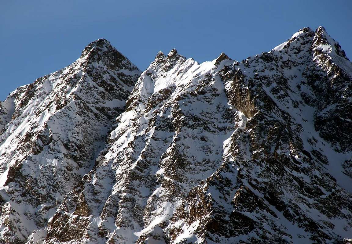
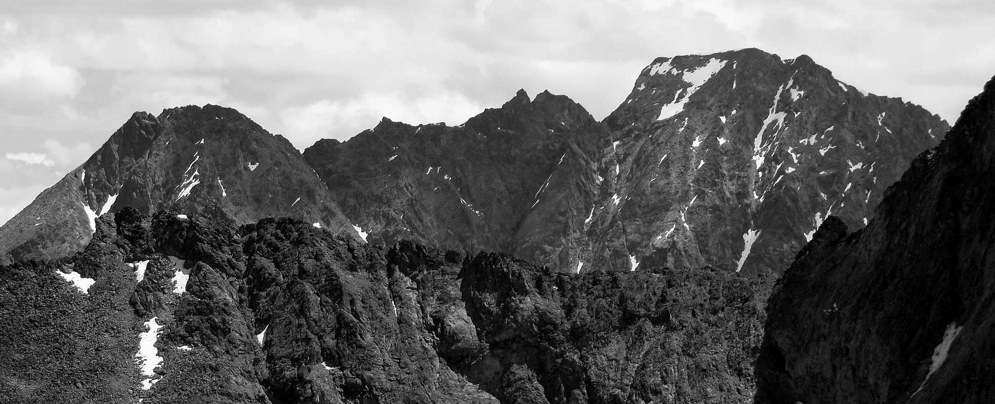
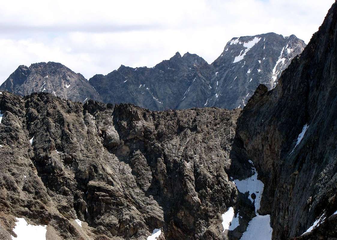
Summit to two twin peaks between the Petite or Little and the Grande Roise (= from Roizà also Glacier) in the homonym small Subgroup watershed acting as, positioned with course South/North, among the Valley of the Laures (Municipality of Grand Brissogne) and of Saint Marcel; practically it unites the Valley of Cogne in the tall part of his "Vallone" Grauson-Lussert, departing from the Point of Leppe, to his Southern extremity, to the Tower of Salé, last layer above the Central Valley of the Dora Baltea Stream. In succession from the Leppe Point (* anciently "Becca" of Leppy, but it dealt with a generic placename addressed to the whole chain as that of Laures, from the root the Eyve or the Water and therefore, and by the way, the Water's Walloon) and "going down" toward Aosta Town we will have therefore: Hill of Leppe, Ilario Antonio Garzotto Point, Great Roise (3.357m, the most elevated into the entire Mountain Chain; even called Tita Plana from the inhabitants, raison the Top in the shape flat shovel) with the its two minuscule Antesummits Southerner and Northerner (you see photo of Anthony in page), the two and twin Points Gianni Junod South and adjoining Northern Pinnacle or Tower North, the tiny but elegant Quota 3.259m, Little Roise with its Antetop Northerner, Pass, "Becca" as well as Salé Tower also called of the Salì, as on the spot known from the inhabitants more old and surely well-informed (private informations, notes, remarks and storys, by Giovanni "Agostino" Zulian). Atypical top or classically of watershed, because formed exclusively from two walls and as many crests in form prepared archered, as well as positioned in the middle of the others two more important and thick Roises; along his sides steep walls of alternate broken rocks to small rocky channels fall. On the Western side or of the Laures a wall goes down, tall middly among the 300 and the 400 meters characterized from a long diagonal rocky-snowy gully, that goes up "cutting" the face from left to right or North/South (sees picture in page of Section "Route"), above the ancient Glacier of the Great Roise, by now meeting place to circumscribed glacial-snowcapped and in effect permafrost, in direction of the Long Lake (2.360m); on the opposed side a well more imposing wall, of over 500 meters, it reaches the Walloon of Saint Marcel falling toward the Alp of Praborna with its manganese mines. Also in this sector small, narrow, horrid as well as unexplored rocky channels separate it from the Little Roise and from the Great one.
 |
IT NOTICES HISTORICAL: in this last couloir you /he should partially be him turn the slope of August 18 th, 1913 from the Baron E. de Beck Peck(c)oz, probably with his mountain guides. These effected the first slope of the Wall N-NE of the Great Roise up to the carving formed by his Crest North with the South Point of the Points Gianni Junod and conclusive pursuance through the Crest North; the same one had already been crossed by Jean Antoine Carrel "The Bersagliere" of the Cervino (Matterhorn) with Angelo Decaroli and Albino Lucat in July 17th, 1857, as from RM 1922, page 137, where however the run is described contrarily amiss. But the first absolute certain of the Points Gianni Junod is probably up to, and almost surely, to Hans of Entrèves in the Summer of 1914 as from "list of the summer trips" in which is quoted as "first ascension without guides", you see RM of the C.A.I. of 1915 to the page 121; it would be able however in effects to already have been climbed from the party Carrel, sees his facility. The other crossing of the epic known epic, finished from Agostino Ferrari with the mountain carrier of Cogne B. Glarey Sep 15 th, 1898, it happened in opposite sense or with direction South/North from the Pass of Leppe to that of Salé; in the same one he brings: "... Descent for the crest North also it doesn't deprive of difficult footsteps and surmounted by conspicuous spikes. Says peak it finishes to a pronounced carving… As first ascent I propose the name of Petite Roise.", as from RM 1898, page 489. In it instead and in fact it is not mentioned the Central Roise to the slope of the same costituents. Well different the discourse of the Tower North that surely asks for greater appointment owed to relative difficulties; the same was climbed by Osvaldo Cardellina and Joseph Lamazzi in integral crossed from "Becca" of Salé to the Great Roise, Aug 4 th, 1985. You see Book of the Shelter Ernest Ménabreaz 1985 with squirt and Guide C.A.I./T.C.I. "Emilius Rosa of the Banks Park of the M. Avic", page 147 (in which however the slope is amiss dated 1993), by Giulio Berutto and Lino Fornelli, Editted in March 2005). Ancient called Central Roise, from 1978 took the name of Point also Points Junod, in memory of Gianni Junod, fallen with Ilario Antonio Garzotto on Aiguille Jean Joseph Croux, (Arthur Ottoz route) Sep 29th 1969. After a first attempt effected from Osvaldo Cardellina, Camillo Roberto Ferronato and Franco Lucianaz, the first two of the Fraction of Pian Felina and one of that of Valpettaz (always Commune of Charvensod) of Sep 5/6 th, 1996, frustrated by a violent storm of snow, the positioning of the Cross in memory happened Jul 22 th, 2006, from Giovanni Matteo" Agostino" Zulian (+ in August of 2011) of Grand Brissogne and by Ernesto Ciocchetti of Pian Felina. These last two transported the small cross, "hidden" momentarily on the Peak of Salé also "Becca" of Salé, and, climbed over in crossing the Little Roise, they stared at it on the Southern Summit, to the appearance the most elevated. This way, simultaneously to the laying of the Cross on the neighbor, always on the same mountain Chain and as soon as to South of the Great Roise, Ilario Antonio Garzotto Point (3.273/4m around), happened Sep 29 th, 1994 from a numerous group of friends, they are remembered as well as handed down the memory of these two very young and strong mountain climbers of Aosta Town, that a crucial Destiny has united forever. Both very rarely frequented (as of however the whole Chain of the Roises (small Subgroup of Mount Emilius), excluded the easy and near one "Becca" of Salé) for the length of the approach, and besides because of tiresome aspect, introduces a splendid sight on the vertical East Wall of the Emilius Mountain, high 500 meters, and on the Lakes des Laures, as well as splendid glimpses on the two near Roises, from which are circumscribed and "you embrace." However a trip into basin of the Laures Walloon is already deserving than for herself of a visit that, if united to a slope to the not difficult Hill of Salé (3.108m; in ancient times called Pass of the Great Roise) and to the homonym impending "Becca", they allow to become himself account of the wild majesty of the small mountainous chain (to the hill stand flocks of about ten, sitting with tranquillity, steinbocks that, whereas excessively disturbed not, they surely cheer so much the desires of the Photographer of mountain how much the curiosities and the desires of the Naturalist).
Sommità a due piccole vette gemelle tra la Petite e la Grande Roise nell'omonimo piccolo Sottogruppo fungente da spartiacque, posizionato con andamento Sud/Nord, tra i Valloni delle Laures (Comune di Grand Brissogne) e di Saint Marcel; praticamente lega, partendo dalla Punta di Leppe, alla sua estremità Meridionale, alla Torre di Salé, ultima propaggine sopra la valle Centrale della Dora Baltea. In successione dalla Leppe (* anticamente "Becca" di Leppy, ma trattavasi di toponimo generico indirizzato all'intera catena, come quello di Laures, dalla radice l'Eyve ovvero l'Acqua e quindi, ed a proposito, Vallone dell'Acqua)) e "scendendo" verso Aosta avremo quindi: Colle di Leppe, Punta Ilario Antonio Garzotto, Grande Roise (3.357 metri, punto più elevato dell'intera Catena; in loco come Tita Plana, per la forma "pianeggiante" a mò di sottile e piatto badile della sua vetta) con le sue due minuscole Antecime Meridionale e Settentrionale (vedi foto di Antonio in pagina), le due gemellari Punte Gianni Junod Sud ed attiguo pinnacolo o Torrione Nord, la piccola, graziosa ed elegante Quota 3.259 m, Petite Roise con la sua Antecima Settentrionale, Colle, "Becca" nonché Torre di Salé o del Salì, come in loco conosciuta dai valligiani più anziani e sicuramente meglio informati (private informazioni, note storiche, relazioni ed osservazioni, da parte di Giovanni "Agostino" Zulian). Cima atipica o classicamente di spartiacque, perché formata esclusivamente da due pareti ed altrettante creste sagittalmente disposte, nonchè posizionata in mezzo all'altre due più importanti e massicce Roises; lungo i suoi fianchi cadono ripide pareti di rocce rotte alternate a piccoli canali rocciosi. Sul lato Occidentale o delle Laures scende ne scende una, alta mediamente tra i 300 ed i 400 metri e caratterizzata da un lungo canalone diagonale che sale "tagliando" la parete da sinistra a destra Nord/Sud ( vedi la foto in pagina nella Sezione "Route"), sopra l'antico Ghiacciaio della Grande Roise, ormai ridotto a circoscritto glacionevato ed in effetto permafrost, in direzione del Lago Lungo (2.632 m); sul lato opposto una parete ben più imponente, di oltre 500 metri, raggiunge il Vallone di Saint Marcel precipitando verso l'Alpe di Praborna con le sue miniere di manganese. Anche in questo settore angusti, stretti, orridi nonché inesplorati canali rocciosi la separano dalla Petite Roise e dalla Grande. * NOTA STORICA: in quest'ultimo canalone dovrebbe essersi parzialmente la salita del 18 Agosto 1913 da parte del Barone E. de Beck Peck(c)oz, probabilmente con le sue guide, con prima salita della Parete N-NE della Grande Roise fino all'intaglio formato dalla sua Cresta Nord con la Punta Sud delle Punte Gianni Junod e proseguimento conclusivo attraverso la Cresta Nord, già percorsa da Jean Antoine Carrel "Il Bersagliere" del Cervino con Angelo Decaroli ed Albino Lucat nel Luglio 1857, come da RM 1922, pagina 137, dove però il percorso viene erroneamente descritto al rovescio. Ma la prima assoluta certa delle Punte Gianni Junod spetta probabilmente, e quasi sicuramente, ad Hans d'Entrèves nell'Estate del 1914 come da "elenco delle gite estive" nel quale è citata come "prima ascensione senza guide", vedi RM del C.A.I. del 1915 alla pagina 121; potrebbe però essere già stata salita dalla comitiva Carrel, vista la sua facilità. L'altra traversata dell'epica epopea conosciuta, compiuta da Agostino Ferrari con il portatore di Cogne B. Glarey il 15 Settembre 1898, avvenne in senso opposto ovvero con direzione S/N dal Colle di Leppe a quello di Salé; nella stessa si riporta: " ... Discesa per la cresta Nord pur essa non priva di passi difficili e sormontata da cospicui spuntoni. Detta vetta termine ad un intaglio pronunciato … Come primo salitore propongo il nome di Petite Roise.", come da RM 1898, pagina 489. In essa invece ed infatti non si accenna alla salita dei medesimi costituenti la Roise Centrale. Ben diverso il discorso del Torrione Nord, tale da richiedere sicuramente maggior impegno dovuto a relative difficoltà; lo stesso venne salito da Osvaldo Cardellina e Giuseppe Lamazzi in integrale traversata dalla Becca di Salé alla Grande Roise, il 4 Agosto 1985. Vedi Libro del Rifugio Ernesto Ménabreaz 1985 con schizzo e Guida C.A.I./T.C.I. "Emilius Rosa dei Banchi Parco del M. Avic", pagina 147 (nella quale però la salita viene erroneamente datata 1993), di Giulio Berutto e Lino Fornelli, Editata nel Marzo 2005 ). Anticamente chiamata Roise Centrale, dal 1978 ha preso il nome di Punta o Punte Junod, in memoria di Gianni Junod, caduto insieme ad Ilario Antonio Garzotto all'Aiguille Jean Joseph Croux, parete SE, via Ottoz il 29 settembre 1969. Dopo un primo tentativo effettuato da parte di Osvaldo Cardellina, Camillo Roberto Ferronato e Franco Lucianaz, i primi due della Frazione di Pian Felina ed uno di quella di Valpettaz (sempre Comune di Charvensod) del 5/6 Settembre 1996, frustrato da una violentissima tempesta di neve, il posizionamento della Croce in memoria avvenne il 22 Luglio 2006, da parte di Giovanni Matteo "Agostino" Zulian (+ nell'Agosto del 2011) di Grand Brissogne e di Ernesto Ciocchetti di Pian Felina. Questi ultimi due trasportarono la piccola croce, "nascosta" momentaneamente sulla Vetta della Becca di Salé, e, scavalcata in traversata la Petite Roise, la fissarono sulla Sommità Meridionale, all'apparenza la più elevata. Così, simultaneamente alla posa della Croce sulla viciniora, sempre sulla medesima Catena ed appena a Sud della Grande Roise, Punta Ilario Antonio Garzotto (3.273/4 m~), avvenuta il 29 Settembre 1994 da parte di un folto gruppo di amici, vengono ricordati nonché tramandata la memoria di questi questi due giovanissimi e valenti alpinisti aostani, che un cruciale Destino ha accomunato per sempre. Entrambe molto raramente frequentate (come d'altronde tutta la Catena delle Roises, esclusa la facile e vicina Becca di Salé) per la lunghezza dell'avvicinamento, ed inoltre perché di aspetto ostico, presentano una splendida vista sulla verticale Parete Est del Monte Emilius, alta di 500 metri, e sui Laghi des Laures, nonché splendidi colpi d'occhio sulle due vicine Roise, dalle quali vengono circoscritte ed "abbracciate". Comunque già una gita nel bacino del Vallone delle Laures é meritevole di per se stessa di una visita che, s'accomunata ad una salita al non difficile Colle di Salé (3.108 m) ed alla soprastante omonima "Becca", permettono di rendersi conto della selvaggia maestosità della piccola catena montuosa (al colle stazionano branchi di una decina di stambecchi sdraiati tranquillamente che, laddove non eccessivamente disturbati, allietano sicuramente tanto le voglie del Fotografo di montagna quanto le curiosità ed i desideri del Naturalista).
First Ascents
Little Tower N (3.295m~):- First on the summit (from Little N Wall, in crossing from Becca di Salè to Grande Roise): Osvaldo Cardellina and Giuseppe Lamazzi, (Jul 04th, 1985).
- In winter: Unknown.
- Crossing Petite Roise-N and S Summit (from Salè Pass, round trip): Giovanni Matteo "Agostino" Zulian and Ernesto Ciocchetti, (Jul 22th, 2006).
- First on the summit: Hans d'Entrèves, excluding mountain guides, (Summer 1914).
- In winter: Unknown.
- W Wall (from Old W Glacier of Grande Roise and crossing to N Summit-Petite Roise-Becca di Salè): Osvaldo Cardellina, lone, (Dec 08th, 1996).
- Crossing (from Salè Pass-Petite Roise-N and S Summit, round trip): Giovanni Matteo "Agostino" Zulian and Ernesto Ciocchetti, (Jul 22th, 2006).
Getting There
BY CAR:- From Torino, Milano, etc: Motorway A5. Exit at Aosta Est.
- From Switzerland: through the Grand Saint Bernard Tunnel or the namesake Pass. Drive to Aosta.
- From France: through Mont Blanc Tunnel or Petit Saint Bernard Pass. It isn't necessary to take Motorway A5: you can drive on SS.26, in the direction of Aosta.
BY PLANE:
- Aeroporto "Corrado Gex" Saint Christophe (Aosta).
Approach with Variations
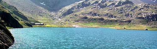
From the Great Brissogne Municipality (894m), toward to continue West along the road up to the poster of prohibition (here than from of becoming in before road in earth "the poderale"); from this point, turning in opposite sense, goes up again up to the Gremonenche Pasture (1.000m around). Always through the same one that from this point and through the path n° 1 it begins his entry in the really truth of Valley of Laures parallely and overhanging the homonym torrent, to the Arp of it arrives of him (1.310m; the writing Larp on a wall of the mountain house). To continue of then, along a run that confining more next to the Laures Torrent, arrives in first succession to the La Vieille Pasture (1.623m) and therefore a that of Le Tramail also called The Tramouail, near a small prairie (1.951m; good shelter in case of bad meteorological conditions; always open and endowed with heater and provisioning). Crossing on a series of small bridges in stone and wood, they happen of him of what a pressing rhythm to the altitude of middly of 2.200/2.400 meters about, the torrent is forded in repeatedly the senses of march bringing himself due in a more open zone, dove the path becomes muletrack true of proper of and, draws of different of underlining they govern recent maintenance.DIRECT VARIATION: mostly starting from this point, precisly in quota 2.191m (small stoneman), a steep run with the path n° 1A, fast more of but more than it addresses of him a right (West), toward the slant Oriental of the "Becca di Seneva", for directly to go up again of then at first long smoothed slabs and therefore they govern path, toward the entrance of access to the Laures Valley, where the walloon him "the throat". Forded the emissary of the Lower Loch through an wooden bridge, it rejoins of him of they govern us the final part of itinerary of they found, in quota 2.567m, nearby a fork (sees under); leaving completely on the left (East) the impending rocky promontory, to the peak of which he has been in 1930 builts the small Chapel (2.613m; slight of perennial signaling) in memory of the fallen ones on the East Wall of the Emilius. On the right (West-southwest) immediately before of th crossroads 2.567m, go up the path n° 8 that it goes up again to the Peckoz Pass (3.042m; easy and beautiful excursion that brings on the crest watershed among Les Laures and wild Walloon of the Arpisson; good photographic perspectives on the East Walls and North and Black Triangle of the Emilius). Contrarily and in opposite sense or to East-southeast, and always from the crossroads 2.567m, it begins the path n° 6A that, gone beyond the aforesaid chapel, it continues to half coast, in aerial form, "cutting" the whole Northwesterner steep Slopes of the Pecks of Salé bringing itself, doubled to the basic on the Crest North the homonym Tower (3.073m), toward the Salé Cross (2.382m) and, after as easy brief down, to Bonplan Pasture (2.374m), in the Walloon of Arpisson-Saint Marcel (not confused to himself with that of the Arpisson-Pollein "Vallone"). Sees approach.
BLACK FOUNTAINS ROUTE: steep Less, as well as fatiguing, toward of run of the and that it almost brings him until against the Wall of the "Becca of Salè" (2.314m; the this is known come to of the of Street Black Fountains, a causes of numerous rivulets of water that gush out and gushing they flow on blackish great blocks of grey gneiss and smoothed by the by now disappeared Glacier of Laures) and sale along the last 400 metersafter twice changes of the direction in quota 2.492 m, on wider slant up to the summit of a series of rocky terraces (2.600 around of the meter; on the promontory of little impending toward of and East, small chapel votive devoted to Jean and Dino Charrey, the very young brothers, and Cino Norat, fallen then in 1929 on him virgin East Wall of the Emilius). Climbed over the wide saddle and they govern through a short and in left diagonal (Southeast), passing as soon as above the Laures Dessous Loch or Inferior, the of it reaches of I am Sheltered Ernesto Ménabreaz (2.542m; the privacy, but always open of free of and, also in winter; the heater (firewood of the to go himself, even if it is in endowment of it); the beds a castle for 8 places, covers and provisions they govern table, as well as chairs.
VARIANTE DIRETTA: cominciando da questo punto, precisamente a quota 2.191 m (ometto in pietra, non sempre facilmente individuabile per chi non conosce bene la strada), un percorso tramite sentiero n° 1A maggiormente ripido, ma più veloce, si indirizza più a destra (W), verso i pendii Orientali della Becca di Seneva, per poi risalire direttamente, dapprima lungo lastroni levigati e quindi con un sentierucolo, verso l'imbocco d'accesso alle Laures, dove il vallone si "strozza", lasciando completamente sulla sinistra il soprastante promontorio roccioso, al culmine del quale é stata nel 1930 edificata la Cappelletta in memoria dei caduti sulla Parete Est dell'Emilius. Guadato l'emissario del lago tramite un piccolo ponte in legno, ci si ricongiunge in breve con la parte finale dell'itinerario di base, a quota 2.567 m, presso un incrocio (vedi sotto); lasciando completamente sulla sinistra (E) il soprastante promontorio roccioso, al culmine del quale é stata nel 1930 edificata la piccola Cappella (2.613 m; luce di segnalazione perennemente accesa) in memoria dei caduti sulla Parete Est dell'Emilius. Sulla destra (O-SO) e subito prima dell'incrocio 2.567 m, si diparte il sentiero n° 8 che risale al Col Peckoz (3.042 m; facile e bella escursione adducente sulla cresta spartiacque tra Les Laures ed il selvaggio Vallone dell'Arpisson; ottime prospettive fotografiche sulle Pareti Est e Nord e Triangolo Nero dell'Emilius). Al contrario sempre dal bivio 2.567 m ed in senso opposto, ovvero a E-SE, inizia il sentiero n° 6A che, oltrepassata la predetta cappella, prosegue a mezzacosta tagliando in maniera "aerea" tutto i ripidi Versanti Nordoccidentali della Becca di Salé portandosi, doppiata alla base sulla Cresta Nord l'omonima Torre (3.073 m), verso la Croix de Salé (2.382 m) e, dopo breve e facile discesa, all'Alpe di Bonplan (2.374 m), nel Vallone di Arpisson-Saint Marcel (da non confondersi con quello dell'Arpisson-Pollein).Vedi appresso.
VIA delle FONTANE NERE: meno ripido, nonché faticoso, il percorso verso levante che si porta fino quasi contro la Parete O della Becca di Salè (2.314 m; questo è conosciuto come Via delle Fontane Nere, causa dei rivoletti d'acqua che sgorgano e zampillando scorrono copiosi su grandi blocchi in gneiss grigio nerastri e levigati dall'ormai scomparso Ghiacciaio delle Laures) e sale, dopo aver variato due volte direzione a quota 2.492 m, lungo gli ultimi 400 metri su pendii più ariosi fino al colmo di una serie di terrazzamenti rocciosi (2.600 metri circa; sul promontorio, di poco soprastante e verso Est, piccola cappella votiva dedicata ai fratelli Jean e Dino Charrey ed a Cino Norat, precipitati giovanissimi nel 1929 sull'allora inviolata Parete Est dell'Emilius). Scavalcata la larga sella e con una breve discesa in diagonale a sinistra (Sudest), passando appena sopra il Lago Dessous od Inferiore delle Laures, si raggiunge il Rifugio Ernesto Ménabreaz (2.542 m; privato, ma sempre e gratuitamente aperto, anche in inverno; stufa (portarsi la legna, anche se ve ne è in dotazione); letti a castello per 8 posti, coperte e vettovaglie con tavolo, nonché sedie.
Route
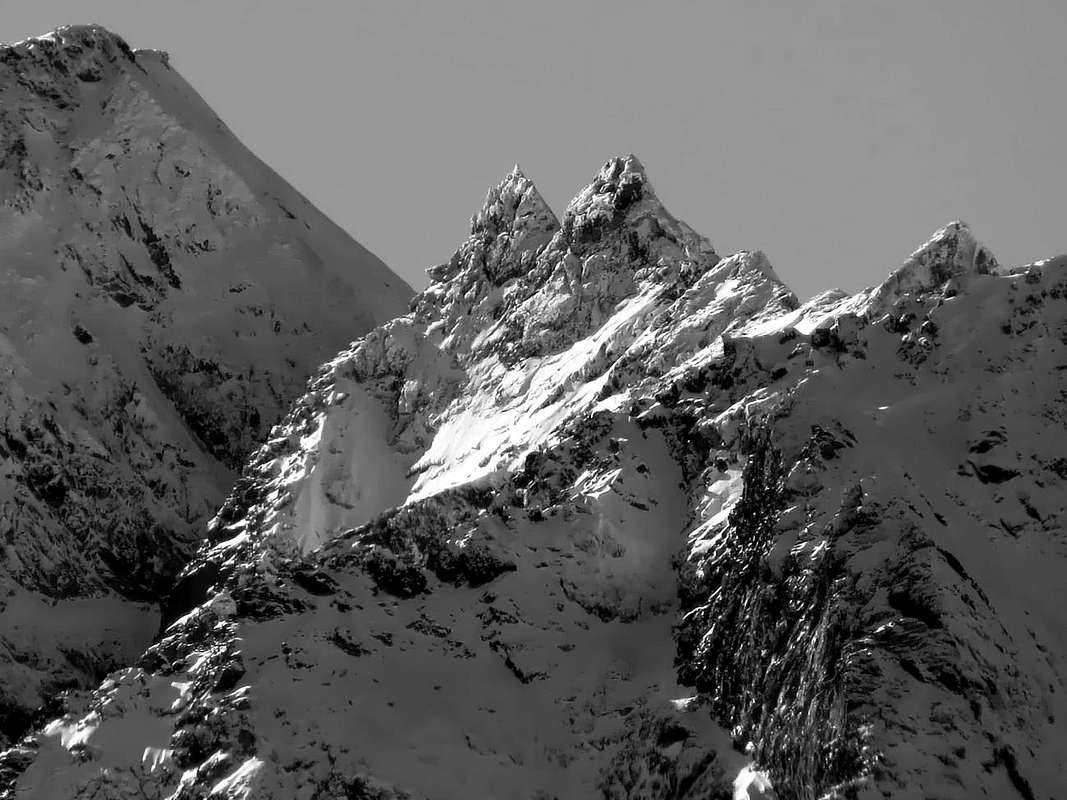
From the Shelter Ernesto Ménabreaz to continue on the path that conducts to the Long Lake of Laures (2.632m); later around hundred meters, to turn toward Northeast in direction of the Pass of the Great Roise or Salé Pass, as currently better known (3.008m). From the pass, formed from to vast terrace stony-debris and where to flock of gifts often sojourns and splendid steinbocks, to easily go up again (draws with possibility to walk) toward South the slant uniform, on traces and in the middle of small rocks, of the Slope North of the Little Roise (3.273m); the same transforms him, in the last 150 meters, in to small, short as well as easy Crest N-NW. To overcome it for rocks broken and rotten of I°/I°+ reaching the Antetop North of the Petite Roise (3.270m~). To go down with a passage exposed, less of 10 meters, to the following carving (known by the hunters on the spot as "Pas du Bâton" = "Passage of the Stick"; II°/II°+, exposed) and to reach the Top (II°+/III°-; 3.273m~). To continue toward South and, crossing even and easily the unnamed Quota 3.259 meters, and the following a small saddle (3.247m), to climb, after a brief treat with gradual ascent on broken rocks, bringing himself at the base of the more Northerner of two twin points; with enough difficult climb (the first climbers, cause the "verglass", they touched the peak with the alone hand of the first one of rope) the first little Tower from North (3.297/8m~). I come down by this with the identical street, to cross on the right (West or side of the Laures) for an exposed and almost horizontal ledge, but not difficult, at the base of the tower added her "cutting it" in the sense North/South; to go himself, revolving it, so toward the second it aims of small triangular form, reaching a tiny fork suffered awry of the same one (South). Easily for the Southern Face to reach the Summit, the most elevated, at least in appearance (F+/PD-; I°+ and II°- for the South Point; PD+/AD- for the Spire North; 3h'00/3h'30 for both, from the Refuge Ménabreaz).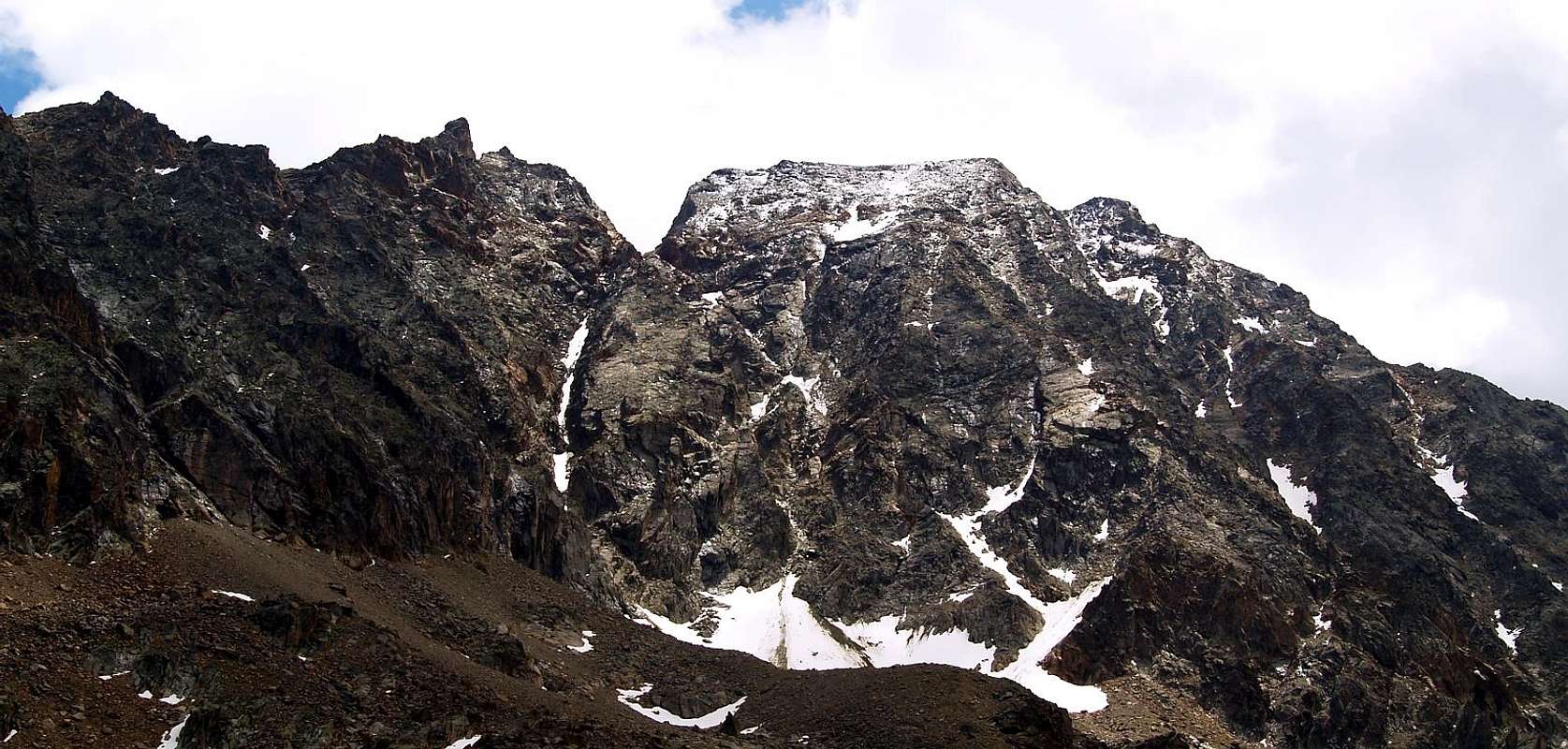
L'itinerario è classificato PD+ (Poco Difficile+) dipende dalle condizioni della montagna.
Equipment
Mountaineering equipment including rope, helmet.Da alpinismo, corda e casco.
Huts
|
Campings
Remember that free camping is forbidden (except for emergency reasons, over 2.500m, from darkness until dawn).Mountain Condition
- Meteo: you can find all the needed informations at the official site of the Valle d'Aosta Region:
- Valle d'Aosta Meteo
Webcam
- WEBCAM on Aosta Valley:
- Webcam
Old images of Gianni Junod
 |
 |
 |
 |
 |
 |
Books and Maps
BOOKS:- "Guida delle Alpi Occidentali" di Giovanni Bobba e Luigi Vaccarone C.A.I. Sezione di Torino Volume II (parte II), 25 Maggio 1896.
- "Guida del Monte Emilius" di Osvaldo Cardellina Editore in collaborazione con il Club Alpino Italiano Sezione di Aosta, Dicembre 1978 (in Italian).
- "Ascensioni 1964-1969" Diario Alpinistico di Ilario Antonio Garzotto (unpublished).
- "Diari Alpinistici" di Osvaldo Cardellina e Indice Generale accompagnato da Schedario Relazioni Ascensioni 1964-2019 (unpublished).
- "Guida dei Monti d'Italia – Emilius Rosa dei Banchi-Parco del Mont Avic" di Giulio Berutto e Lino Fornelli - Club Alpino Italiano/Touring Club Italiano, Marzo 2005.
 |
 |
 |
 |
 |
- Kompass "Gran Paradiso Valle d'Aosta Sentieri e Rifugi" Carta Turistica 1:50.000.
- Hapax "Les Sentiers" Comunità Montana Monte Emilius, Luglio 2000 1:25.000.
- Enrico Editore Ivrea-Aosta "Gruppo del Gran Paradiso" 1:50.000.
- L'Escursionista "Valle di Cogne" Carta dei Sentieri 1:25.000.
- L'Escursionista "Tour de la Vallée de Cogne Grand Paradis" Carta dei Sentieri 1:25.000.
- Hapax "Les Sentiers de Charvensod" Comune di Charvensod, Giugno 2003 1:25.000.
Important Information
- REGIONE AUTONOMA VALLE D'AOSTA the official site.
- FONDAZIONE MONTAGNA SICURA Villa Cameron, località Villard de la Palud n° 1 Courmayeur (AO) Tel: 39 0165 897602 - Fax: 39 0165 897647.
- A.I.NE.VA. (Associazione Interregionale Neve e Valanghe).
Mountain Album, by Gianni Junod
 |
 |
 |
 |
 |
 |
 |
 |
 |
 |
 |
 |
 |
 |
 |
 |
 |
 |
 |
 |
Useful numbers
- Protezione Civile Valdostana località Aeroporto n° 7/A Saint Christophe (Ao) Tel. 0165-238222.
- Bollettino Meteo (weather info) Tel. 0165-44113.
- Unità Operativa di Soccorso Sanitario Tel. 118.
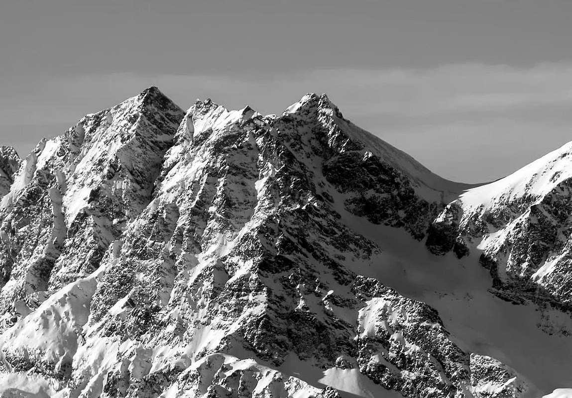
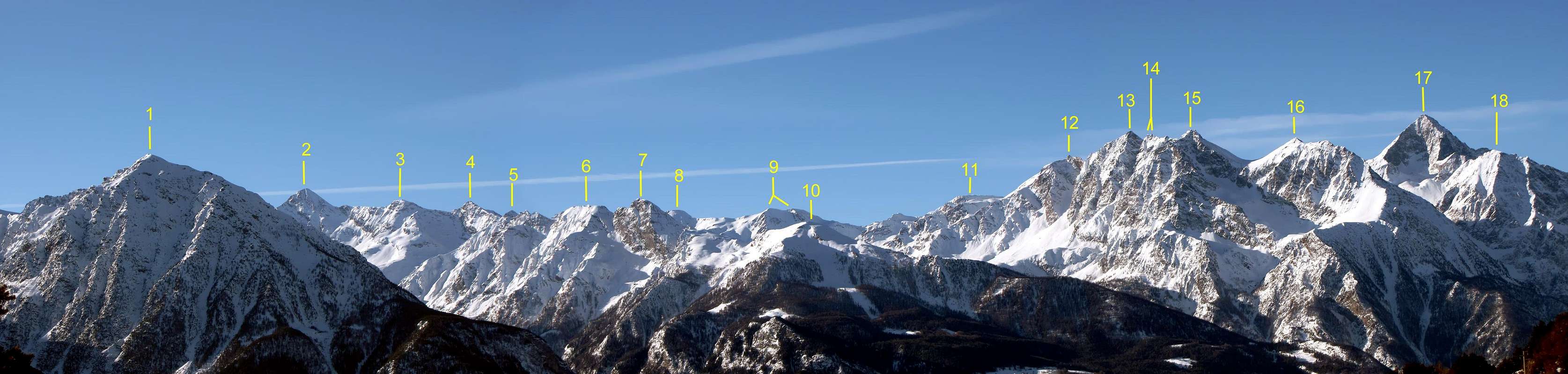
The SUBGROUP of the GRANDE ROISE (3.357m) to Salè Pass (3.108m) and over Arpisson's-Salé's-Bonplan's Valley in Saint Marcel Valley; seen from North-northeastern. Left order: Ilario Antonio Garzotto Point (partial of North Ridge), Carving 3.185/90m, Great Roise, Carving 3.285/90 around, two Gianni Junod Points, Saddle 3.247m, Unnamed Peak 3.259m, more large Saddle 3.250m around, Little Roise (to right the Normal Route at the beginning of complete traverse toward Junod and Great Roise Points), "Pas du Baton" 3.260/3m about, Antesummit Northerner, Salé's Pass and "Becca" (partial detail of the South Crest or Standard Route).