
-
 6115 Hits
-
 84.27% Score
-
 18 Votes
|
|
Mountain/Rock |
|---|---|
|
|
45.61923°N / 7.41955°E |
|
|
Mountaineering |
|
|
Summer, Fall |
|
|
10545 ft / 3214 m |
|
|
Overview
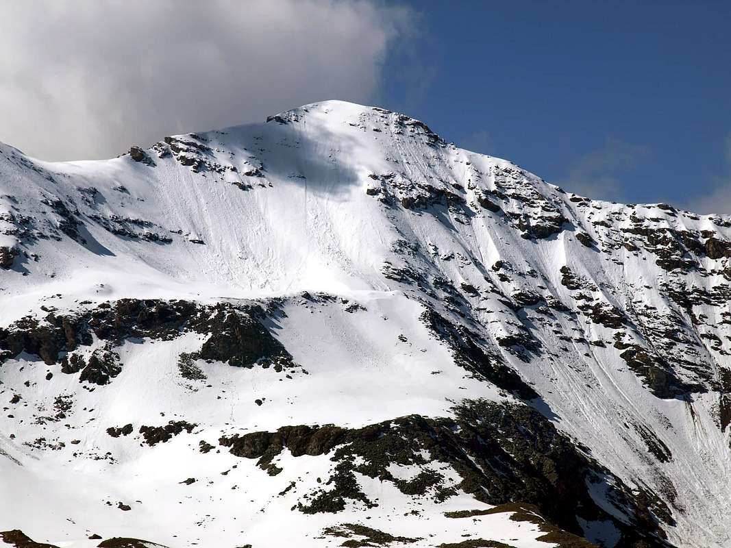
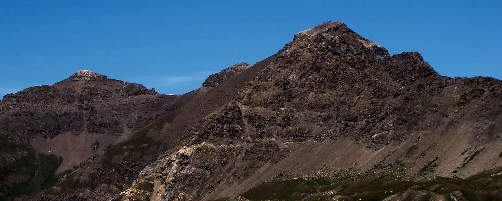
Mountain sited between the West Summit of Penne Blanche (3.205m) and Testa di Money (3.130m) in spur between Urtier Valley in South and Grauson-Doreire Valley in North, both in Cogne Valley. More specifically this Summit is located between Col Coupée (3.130m) to the East, just after the Top of the Western Penne Blanche, and a collar next (3.185m) which precedes the Testa (Head) of Money (3.130m). Its slopes are composed of broken rocks, the North, and even rocks crumbled on both Southeast and Southwest Slopes, divided among themselves by a small but well in evidence buttress, between them forming the Valley of Farcoz to the West by a second above the Pasture of Seutse on the opposite side. All three are less suitable for climbing, although the North side, if snowy, offers a fun ascent on a long Edge North that goes down over the Puy-de-Vardettaz (2.574m), separating lakes Money West (2.550m) and Tzte or Testa (2.753m; Head) to the East. In any case the two routes are preferred ridge coming from the West, that is, from Monte Creya Creya (3.015m), or even from the East by the Pas d'Invergneux (2.902m), bypassing the two Penne Blanche Eastern and Western (3.252m, 3.205m). However it remains a better place to Hunters chamois that the Mountaineers, as it requires a good ability to be able to move without adequate security on land often treacherous. As already said, best avoided.
Good views to Emilius-Punta Rossa-Pic Garin-Tour Grauson Group in Northern and to Gran Paradiso Montain Chain in Southern. Area rich in beautiful lakes in Northern sector; specifically three Doreire under invergneux Pass, Money to the Northwest, four Lussert Northwest, Corona North.
![]()
Montagna situata tra il Penne Blanche Ovest (3.205 m) e la Testa di Money (3.130 m) sulla Costiera tra il Vallone dell'Urtier a Sud e quello di Grauson-Doreire a Nord, entrambi in Valle di Cogne. Più specificamente questa Sommità è collocata tra il Col Coupée (3.130 m) ad Est, subito dopo la cima Occidentale del Penne Blanche, ed un colletto successivo (3.185 m) che precede la Testa di Money (3.130 m). I suoi versanti sono composti da rocce rotte, quello Settentrionale, e da rocce addirittura sgretolate sui due Versanti Sudest e Sudovest, divisi tra di loro da un piccolo ma bene in evidenza contrafforte, che li separa formando il Vallone di Farcoz ad Occidente da un secondo sopra l'Alpeggio di Seutse sul lato opposto. Tutti e tre sono poco adatti alla arrampicata, anche se il versante Nord, se innevato, offre una divertente salita su d'un lungo spigolo Nord che scende fino sopra il Puy-de-Vardettaz (2.574 m), separando i Laghi di Money ad Ovest (2.550 m) e di Tzte o Testa (2.753 m) ad Oriente. In ogni caso sono da preferirsi i due percorsi in cresta arrivando da Ovest, cioè dal Monte Creya (3.015 m), od addirittura da Est dal Pas d'Invergneux (2.902 m), scavalcando i due Penne Blanche Orientale ed Occidentale (3.252 m, 3.205 m). Comunque rimane un terreno più adatto ai Cacciatori di camosci che agli Alpinisti, poiché richiede abilità di sapersi muovere sul terreno a volte infido e senza adeguata possibilità di effettuare le dovute assicurazioni. Solo l'eperienza di anni può essere d'aiuto; come già detto, meglio evitare restando su tracciati in cresta certamente più sicuri.
Ottime vedute su Emilius-Punta Rossa-Pic Garin-Tour Grauson e sul Massiccio del Gran Paradiso. Zona ricca di bei laghi sul settore Nord (Money, Doreire, Lussert, Corona).
![]()
![]()
Good views to Emilius-Punta Rossa-Pic Garin-Tour Grauson Group in Northern and to Gran Paradiso Montain Chain in Southern. Area rich in beautiful lakes in Northern sector; specifically three Doreire under invergneux Pass, Money to the Northwest, four Lussert Northwest, Corona North.
Montagna situata tra il Penne Blanche Ovest (3.205 m) e la Testa di Money (3.130 m) sulla Costiera tra il Vallone dell'Urtier a Sud e quello di Grauson-Doreire a Nord, entrambi in Valle di Cogne. Più specificamente questa Sommità è collocata tra il Col Coupée (3.130 m) ad Est, subito dopo la cima Occidentale del Penne Blanche, ed un colletto successivo (3.185 m) che precede la Testa di Money (3.130 m). I suoi versanti sono composti da rocce rotte, quello Settentrionale, e da rocce addirittura sgretolate sui due Versanti Sudest e Sudovest, divisi tra di loro da un piccolo ma bene in evidenza contrafforte, che li separa formando il Vallone di Farcoz ad Occidente da un secondo sopra l'Alpeggio di Seutse sul lato opposto. Tutti e tre sono poco adatti alla arrampicata, anche se il versante Nord, se innevato, offre una divertente salita su d'un lungo spigolo Nord che scende fino sopra il Puy-de-Vardettaz (2.574 m), separando i Laghi di Money ad Ovest (2.550 m) e di Tzte o Testa (2.753 m) ad Oriente. In ogni caso sono da preferirsi i due percorsi in cresta arrivando da Ovest, cioè dal Monte Creya (3.015 m), od addirittura da Est dal Pas d'Invergneux (2.902 m), scavalcando i due Penne Blanche Orientale ed Occidentale (3.252 m, 3.205 m). Comunque rimane un terreno più adatto ai Cacciatori di camosci che agli Alpinisti, poiché richiede abilità di sapersi muovere sul terreno a volte infido e senza adeguata possibilità di effettuare le dovute assicurazioni. Solo l'eperienza di anni può essere d'aiuto; come già detto, meglio evitare restando su tracciati in cresta certamente più sicuri.
Ottime vedute su Emilius-Punta Rossa-Pic Garin-Tour Grauson e sul Massiccio del Gran Paradiso. Zona ricca di bei laghi sul settore Nord (Money, Doreire, Lussert, Corona).
First Ascents
- First on the summit: Unknown.
- In winter: Unknown.
- N Edge: Osvaldo Cardellina solo, (Jun 27th, 1998).

Getting There
BY CAR:- From Torino, Milano, etc: Motorway A5. Exit in Aosta Ovest. Drive to the near Aymavilles. Follow in the direction of Valle di Cogne.
- From Switzerland: through the Grand St. Bernard Tunnel or the homonym Pass). Drive to Aosta, then follow Courmayeur direction on SS.26. Just after Sarre, turn to the left, in the direction of Valle di Cogne.
- From France: through Mont Blanc Tunnel or Petit St. Bernard Pass). It isn't necessary to enter in Motorway A5, you can drive through SS.26 Aosta direction. Before arriving at the Village of Sarre, follow the sign and turn right towards Valle di Cogne.
After Aymavilles, the SR.47 crosses the Villages of Vieyes, Epinel and Cretaz and after about 25 Km. arrives at Cogne (1.534m). Follow the road signs for Gimillan and Lillaz; arrived at a round-about, recently built in proximity of the St. Anthony Chapel, go left along the scenic route leading to the Village of Gimillan (1.787m), 3 Km. after Cogne. Usually no parking problem.
BY PLANE:
- Aeroporto "Corrado Gex" Saint Christophe (Aosta).
Approach & Routes
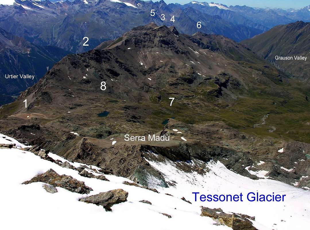
Go right starting from the car park of Gimillan: after few meters the indications for Lussert Lakes, St. Marcel Pass, etc. are found. The pathway is indicated by the yellow circle and by yellow strips marked on stones along the route. The path, always n° 8/TVC, begins going immediately uphill, then the slope decreases as we go beyond a little chapel dedicated to the Virgin (1.836m). Soon the path resumes to go up and splits in two, before it begins to penetrate into the Grauson Valley: it's possible to continue following the right one that goes down as far as the Ecloseur Bridge (1.904m), but in such a case we must go up again; it's better to follow the left one that, in practice without losing height, arrives at the bridge under the Alpeggio Pila (2.025m), cross it and, following the stepped pathway, overcome the rocky bastion beside a fine waterfall (at the left). At this point the path turns right markedly, entering, high on the torrent, into a small walloon; by an alternation of steep and slight slopes, it reaches a panoramic cross, on the edge of a pleasant plateau (superb view of the far La Grivola!). The path goes through the meadows, slightly descendind: after the Alpi di Grauson Vecchie (2271m).
Route A
From Alpi di Grauson Vecchie, by path n° 8C to Money Lake (2.550m); from Lake, through Northeast direction and a small path, to "Puy de Verdettaz" (2.574m). To go up, by South direction, grassy slope and moraine a first balcony, and to reach a snowy "plateau" (tableland) to supere a second strip (Court and of Testa Lake, in East) gradually taking on your right (West) and by Northern Edge, passing in Quota 2.822, 3.002 meters, to terminal little wall (I°/II°; 110 meters; if in very hard snow is better to put the crampons as the slopes rise from 30° also to 40°) and Summit (4h'00/4h'30).
Route B (Usefull even down hill):
To go down in crest to West, little saddle (3.105m) and the following Money Testa (3.130m), F+;I°/I°+), always by ridge and Northwest direction easily to Mount Creya (3.015m From this through grassy slope to Money Lake, and approach above with Via A. Otherwise you can return with a small path n° 5 down to the South in the small and narrow Valley of Mines Liconi reaching those with the same name and those of Colonna (2.390m). A trail n° 9/8D connecting to Northwest leads to the Pastures of Ecloseur, always in the Vallon of Grauson.
 |
 |
 |
 |
 |
Dalla Città di Aosta (583 m), capoluogo dell'omonima regione), si percorre la SS.26 fino all'altezza del bivio che conduce alla ridente località di Aymavilles (646 m), 8 km. da Aosta. Dalla piazza centrale del paese s'imbocca la SR7 e dopo aver oltrepassato le località di Vieyes (1.142 m), ultima frazione di Aymavilles, di Epinel (1.452 m) e Crétaz (1.499 m) si giunge a Cogne (1.534 m) (28 km. da Aosta). Dopo aver attraversato l'intero abitato e raggiunta la cappella di S. Antonio, dov'è stata recentemente costruita una rotonda, prendere la strada comunale che conduce a Gimillan (1.787 m), 3 kilometri da Cogne. Qui posteggiare l'auto nel grande piazzale ed inoltrarsi tra le case; a destra, dopo pochi metri si trovano i cartelli con l'indicazione per i laghi Lussert, il colle di S. Marcel ecc... Il percorso è segnalato con il disco giallo e con strisce gialle lungo il percorso. Dopo aver oltrepassato in un tratto di falsopiano una piccola cappella dedicata alla Madonna (1.836 m), il sentiero, sempre n° 8/TVC, riprende a salire e, prima di iniziare ad addentrarsi nel Vallone di Grauson, si sdoppia; tenersi su quello di sinistra (si può proseguire anche sulla destra verso il ponte di Ecloseur (1.947 m), ma questo obbligherebbe poi ad una noiosa risalita), superare il piccolo ponticello di legno e proseguire fino al ponticello posto sotto l'Alpeggio Pila, attraversarlo e, seguendo il sentiero a gradoni, superare la bastionata rocciosa a fianco della quale scroscia una bella cascata. Ora il vallone gira decisamente sulla destra, un'alternanza di bruschi strappi e tratti in falsopiano conduce ad una croce, sull'orlo di un ameno pianoro, da cui si gode una vista superba della lontana Grivola, percorrerlo sino alle Alpi di Grauson vecchie (2.271 m).
Via A
Dagli Alpeggi proseguire sul sentiero n° 8C fino al Lago del Money (2.550 m); dal lago con direzione Nordest e un piccolo sentiero, verso il "Puy de Verdettaz" (2.574 m). Risalire per morena con direzione Sud una prima balconata, raggiungendo un plateau nevoso; superare una seconda balconata (Laghi Court e di Testa ad Est) spostandosi progressivamente sulla propria destra (Ovest) e per lo Spigolo Nord passando dalle Quote 2.882, 3.002 metri contro la paretina finale (I°/II°; 110 metri; se in neve molto dura é meglio calzare i ramponi poiché le pendenze salgono da 30° anche fino a 40°) in Vetta (4h'00/4h'30).
Via B (Utile anche in discesa):
Scendere ad Ovest in cresta verso la selletta (3.105 m) e la successiva Testa di Money (3.130 m), F+; I°/I°+, sempre in cresta e facilmente con direzione Nordovest al Monte Creya (3.015 m). Da questo per pendii erbosi al Lago di Money, nonché all'avvicinamento di cui sopra con la Via A. Altrimenti é possibile rientrare con un sentierino n° 5 che scende a Mezzogiorno nel piccolo e ristretto Vallone di Liconi raggiungendo le Miniere omonime e quelle di Colonna (2.390 m). Un sentiero di collegamento n° 9/8D verso Nordovest riconduce agli Alpeggi di Ecloseur, sempre nel Vallone del Grauson.
Difficulties
The route can be rated for Expert Hikers with some climbing experience EE/A; F+/PD- in ascent. EE/F+ in descent.
Equipment
Hikers gear, a rope can be useful on the final part.
Campings
Remember that free camping is forbidden (except for emergency reasons, over 2.500m, from darkness until dawn).
Red Tape
The Southern side of the valley belongs to Gran Paradiso National park, the Western one is out of the boundaries of the Park ... but nature must be respected.
Mountain Condition
- You can get meteo information at the official site of the Regione Valle d'Aosta:
Valle d'Aosta Meteo
Webcam
- WEBCAM on Aosta Valley:
- Webcam
Books and Maps
BOOKS:
- "Guida delle Alpi Occidentali" di Giovanni Bobba e Luigi Vaccarone C.A.I. Sezione di Torino Volume II (parte II), 25 Maggio 1896.
- "Guida dei Monti d'Italia Emilius Rosa dei Banchi Parco del Mont Avic" di Giulio Berutto e Lino Fornelli - Club Alpino Italiano/Touring Club Italiano, Marzo 2005.
- "Diari Alpinistici" di Osvaldo Cardellina e Indice Generale accompagnato da Schedario Relazioni Ascensioni 1964-2019 (unpublished).
 |
 |
 |
MAPS:
- Kompass "Gran Paradiso Valle d'Aosta Sentieri e Rifugi" Carta Turistica 1:50.000.
- Enrico Editore Ivrea-Aosta "Gruppo del Gran Paradiso" 1:50.000.
- I.G.C. Istituto Geografico Centrale Torino "Gran Paradiso-La Grivola-Cogne" 1:25.000.
- L'Escursionista "Tour de la Vallée de Cogne Grand Paradis" Carta dei sentieri 1:25.000.
- I.G.C. Istituto Geografico Centrale Torino "Il Parco Nazionale del Gran Paradiso" (3) 1:50.000.
- L'Escursionista "Valle di Cogne Carta dei Sentieri" (n° 10) 1:25.000.
Important Information
- REGIONE AUTONOMA VALLE D'AOSTA the official site.
- FONDAZIONE MONTAGNA SICURA Villa Cameron, località Villard de la Palud n° 1 Courmayeur (AO) Tel: 39 0165 897602 - Fax: 39 0165 897647.
- SOCIETA' GUIDE ALPINE DI COGNE Tel. 347/9473526 – 328/1373728.
- A.I.NE.VA. (Associazione Interregionale Neve e Valanghe).
- A.IA.T. Cogne Gran Paradis via Bourgeois n° 34 Tel. 0165-74040. E-mail: aiat@cogne.org
- Ezio Sport articoli sportivi - via Bourgeois n° 64 Tel. 0165-74204.
Useful numbers
- Soccorso Alpino Cogne (SAR) Tel. 3482685406.
- Protezione Civile Valdostana località Aeroporto n° 7/A Saint Christophe (Ao) Tel. 0165-238222.
- Bollettino Meteo (weather info) Tel. 0165-44113.
- Unità Operativa di Soccorso Sanitario Tel. 118.