


-
 4076 Hits
-
 81.18% Score
-
 13 Votes
|
|
Area/Range |
|---|---|
|
|
45.72330°N / 7.00038°E |
|
|
Hiking, Mountaineering, Trad Climbing |
|
|
Spring, Summer, Fall, Winter |
|
|
6768 ft / 2063 m |
|
|
Note
La montagna chiama i suoi figli, ed essi rispondono fedelmente al suo appello… Osvaldo Cardellina, Diario alpinistico, 1964-65 Page texts: @ OsvaldoCardellina "Osva", passed away on May 2, 2022. Page owners: Christian Cardellina e Osvaldo Cardellina. Any updates from September 12, 2022: Antonio Giani, page administrator, friend and climbing companion. Testi della pagina: @ OsvaldoCardellina "Osva", scomparso il 2 maggio 2022. Proprietari pagina: Christian Cardellina e Osvaldo Cardellina. Eventuali aggiornamenti dal 12 settembre 2022: Antonio Giani, amministratore della pagina, amico e compagno di salite. |
Lakes Overview
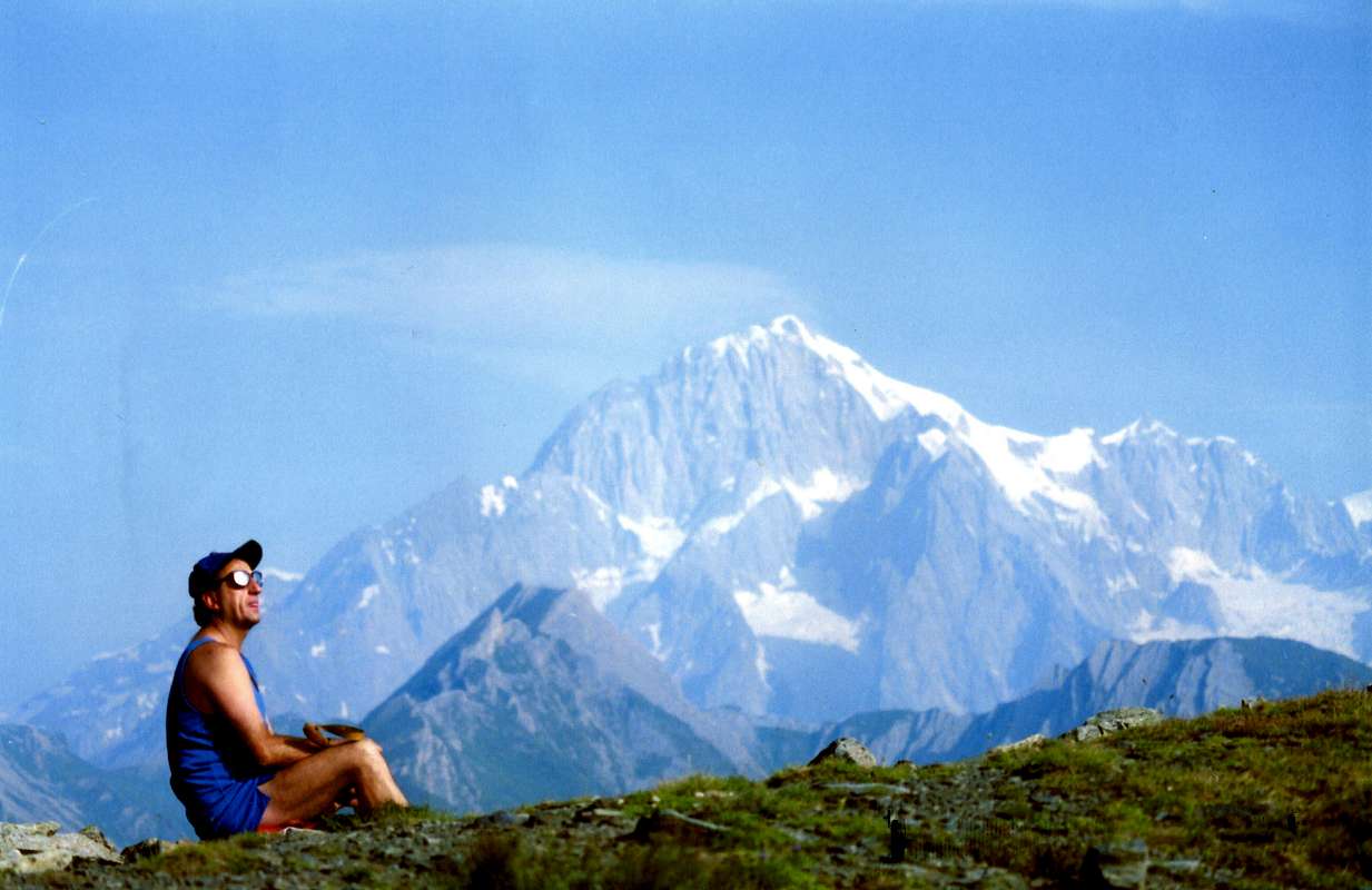
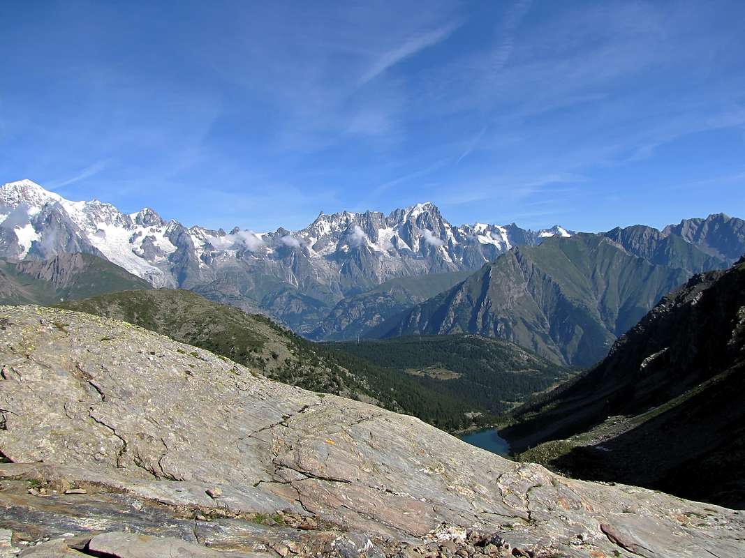
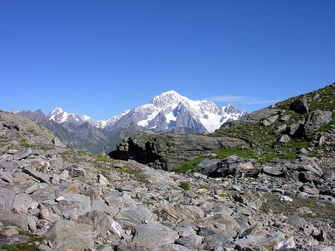
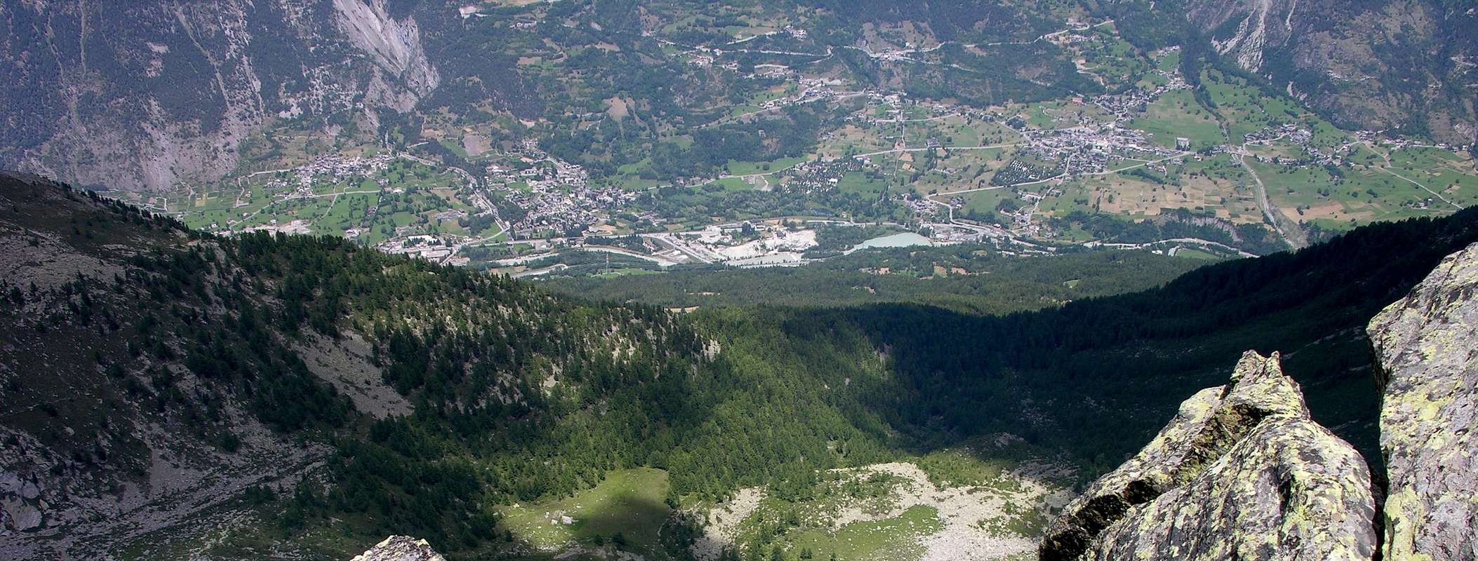
Arpy Basin. This small basin that looms over the Municipaly of Morgex (920m), can be divided into three specific areas of which the first from this center up the hill with the Regional Road first reaching the Village of Arpy (1.680m; small Church of Notre Dame des Neiges) and then, via a private dirt road to the South, the Pastures of Arpy Dèsott and Dessus (1.743m) in front of a beautiful waterfall that comes from the eponymous lake. From the village the road asphalt continues to the right, or the Southwest, reaching the Colle San Carlo (1.971m), important pass that leads to the Valley of La Thuile. Just below the pass there is the Hotel-Restaurant "La Genzianella", very well known and frequented by Tourists in the summer, as well as starting point for the Lake Arpy (2.063m) where the site is in a large plateau with the lake of the same name and which is the second section of this small valley. Subject of attendance by the masses, thanks to its convenient and large farm road, offers exceptional views of the Mont Blanc Mountain Chain, during the first part of the ascent, and then across the divide that by the Colle del Gigante reaches the Gr. Jorasses to then head up to Pt. Jorasses, Aiguille de Leschaux, Mont Greuvetta, Aiguilles de Talèfre, Triolet and Dolent until the end of Val Ferret. This last part is a little "blanket" from the pyramid of Gr. Rochère (3.326m).
 |
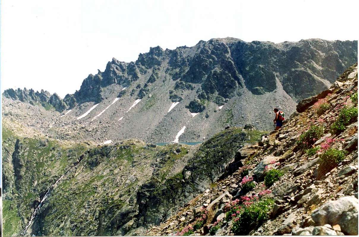
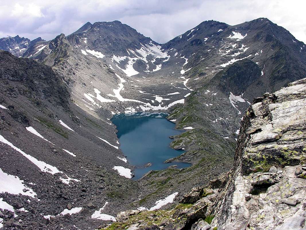
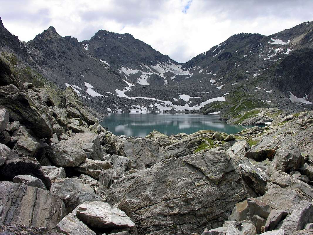
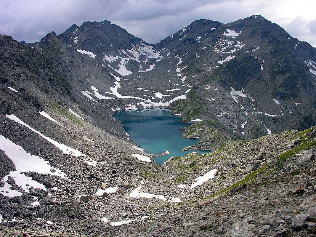
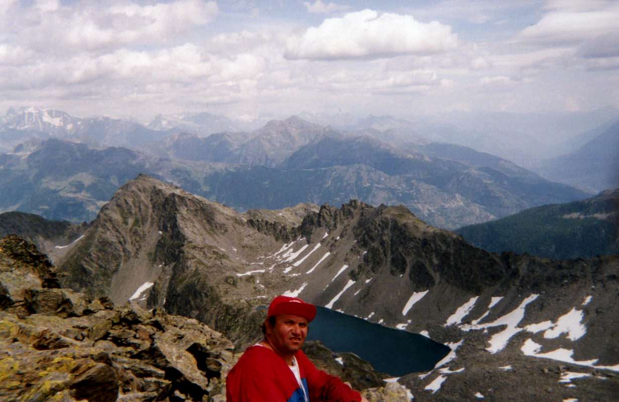
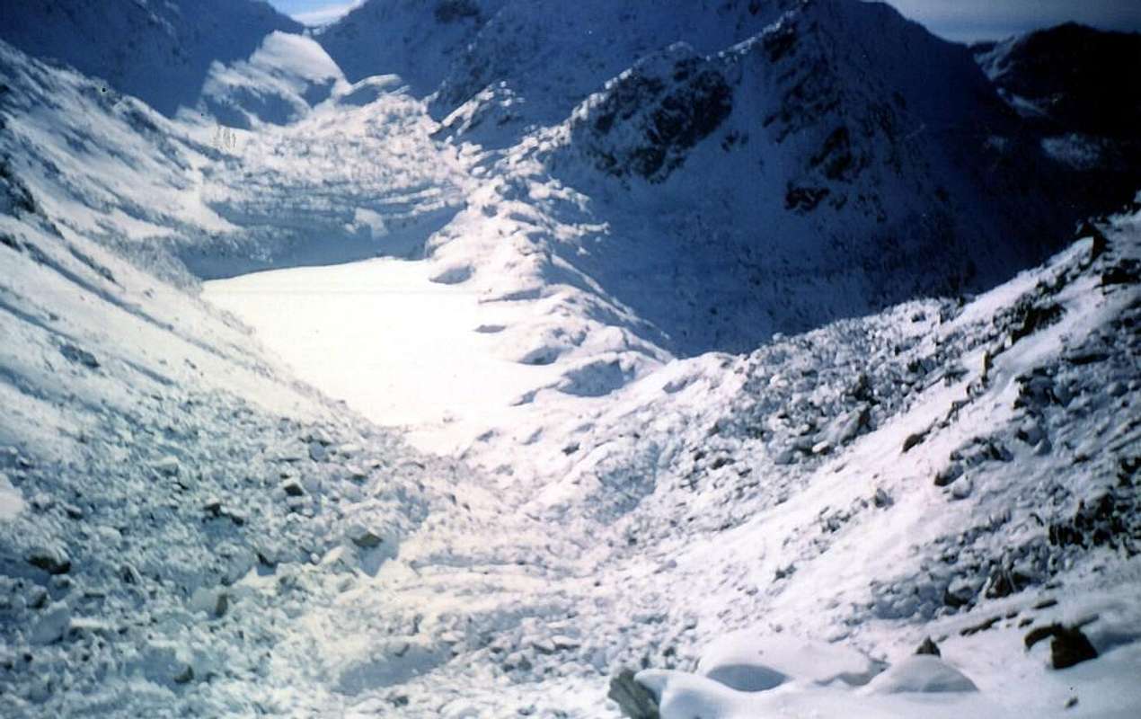
This second sector, after the lake, has a long plateau that runs out against the moraines at the base of the North Face of North Top Mont Colmet (3.020m); this falls to the North-northwest a long ridge with many shelters and fortifications of the Second World War. Reached the Hill of the Cross (2.381m), the same goes to Colle San Carlo, constituting the Western partition with La Thuile, ending the Tête d'Arpy (2.022m), large balcony above the Commons of Pré Saint Didier (to the West) and Morgex, and just across the Summit of Mont Blanc, which here flaunts its full Wall Brenva and tawny Pylons Brouillard and Frêney. From the base of the Northern Slope of Colmet opens instead on the left (Northeast) a big ledge-rocky debris that flows into a second large plateau which stretches the beautiful Lake Pietra Rossa (2.553m), enclosed in the South Summit of Becca Pouignenta (2.797m), Ameran Pass (2.680m), Ameran Ridge (2.758m, 2.713m, 2.975m), Colle della Comba Sorda or Colmet Hill (2.836m; to Rifugio Albert Deffeyes at the foot of Mont Paramont (3.300m) and the great glaciers of the Testa (Head) of Rutor (2.381m) at the end of the glacier of the same name and the South Summit of Mont Colmet (3.024m), the extreme apex of the whole Basin Arpy. At this last idyllic plateau, or rather small basin, is accessed from the underside of the Arpy Lake passing through another intermediate, above a beautiful waterfall, from which rises towards East a short "Via Ferrata" which reaches the emissary of Pietra Rossa (Red Stone). The ascent, through a wide circle semi circular Southeast, is easy, but not in case of snow or ice where, in this situation, presents difficulties and requires great caution.
Conca d'Arpy. Questo piccolo bacino che incombe sopra il Comune di Morgex (920m), può essere suddiviso in tre specifici settori, dei quali il primo da questo centro risale la collina con la Strada Regionale raggiungendo dapprima il Villaggio di Arpy (1.680 m; piccola Chiesa di Notre Dame des Neiges) e successivamente, tramite una strada poderale verso Sud, gli Alpeggi di Arpy Dèsott e Dessus (1.743 m) di fronte ad una bella cascata proveniente dall'omonimo lago. Dal villaggio la strada in asfalto continua verso destra, o Sudovest, arrivando al Colle San Carlo (1.971 m) importante valico che conduce nella Valle di La Thuile. Appena al di sotto del passo esiste l'Albergo-Ristorante "La Genzianella", molto conosciuto e frequentato dai Turisti in estate, nonché punto di partenza, presso un parcheggio con adiacente fontana in legno, per il Lago di Arpy (2.063 m), dove é sito in un grande pianoro il lago dallo stesso nome e che costituisce la seconda sezione di questo vallone. Oggetto di frequentazione da parte delle masse, grazie soprattutto alla sua comoda e larga strada poderale, offre eccezionali vedute sulla Catena del Monte Bianco, durante la prima parte della salita, e poi su tutta lo spartiacque che dal Colle del Gigante raggiunge le Grandes Jorasses per poi dirigersi verso le Petite Jorasses, Aiguille de Leschaux, Mont Greuvetta, Aiguilles de Talèfre, Triolet ed al Mont Dolent insino al termine della Val Ferret italiana. Ma l'ultima parte rimane leggermente occultata, se non si sale più in alto, dalla piramide della Grande Rochère (3.326 m).
Questo secondo settore, dopo il lago, presenta un lungo pianoro che si esaurisce contro le morene basali della Parete Nord della Punta Settentrionale del Mont Colmet; da questa scende sinuosa verso Nord-nordovest una lunga cresta con molti ricoveri e fortificazioni della II° Guerra Mondiale. Raggiunto il Colle della Croce (2.381 m) la medesima prosegue verso il Colle San Carlo o Saint Charles, costituendo il divisorio Occidentale con La Thuile, per poi terminare alla Tête d'Arpy (2.022 m), grande balcone sopra i Comuni di Pré Saint Didier (ad Ovest) e Morgex, nonché proprio di fronte alla Sommità del Bianco, che qui ostenta pienamente la sua Parete Orientale della Brenva ed i fulvi Piloni del Brouillard e di Frêney. Dalla base del Versante Settentrionale del Colmet si apre invece sulla sinistra (Nordest) una grande cengia inclinata detritico-rocciosa confluente in un secondo grande pianoro nel quale si allunga lo splendido Lago di Pietra Rossa (2.553 m), racchiuso tra la Sommità Sud della Becca Pouignenta (2.797 m), il Colle (2.680 m) e la Cresta di Ameran (2.758 m, 2.713 m, 2.975 m), il Colle della Comba Sorda o del Colmet (2.836 m; lo stesso porta al Rifugio Albert Deffeyes ai piedi del Mont Paramont (3.300 m) e dei grandi ghiacciai della Testa del Rutor (2.381 m)) al termine dell'omonimo ghiacciaio e la Punta Sud del Mont Colmet o Cormet (3.024 m), apice estremo di tutta la Conca di Arpy. A quest'ultimo idilliaco pianoro, o meglio bacino, si accede da quello sottostante del Lago d'Arpy passando tramite un altro più ristretto ed intermedio, soprastante una bella cascata, dal quale sale verso Oriente una breve "Via Ferrata" raggiungente l'emissario del Lago di Pietra Rossa. La salita, tramite un largo giro semicircolare a Sudest, é facile, ma non in caso di neve o ghiaccio sulle levigate banconate rocciose ove, in questa situazione, presenta difficoltà e richiede molta prudenza.
 |
 |
 |
 |
 |
Getting There
BY CAR:
- From TORINO, MILANO, etc: Motorway A5. Exit at IVREA or Quincinetto (PIEDMONT) From IVREA Town: in West (Southern side) to Pont Saint Martin, Donnas, Bard, Champdepraz, Pontey, Fénis, Saint Marcel, Grand Brissogne, Pollein, Charvensod, Gressan, Jovençan, Aymavilles, to Villeneuve, Arvier, Avise and Morgex Municipalities. From Courmayeur Resort: in East towards Morgex Municipality.
- Internal Dora Baltea Areas from Morgex to Arpy Conca From Morgex (920m), with Regional Road in South, towards Liarey, Pre Villair, Mont Rotie, alternative around 1.275m just before Tirecagne Pasture (1.532m), with dirt road in Southeast, towards Costablinaz de Meitin Pasture (1.420m), after through path, towards Damon (1.445m), Champex (1.519m) Pastures, Plan Rançon Alp (2.098m) to Becca Pouignenta Northern Area.
- From Morgex (920m), crossing the bridge above Baltea with Regional Road in South, towards Liarey, Pre Villair, Mont Rotie small Villages, alternative around 1.275m) just before Tirecagne Pasture (1.532m) and the Main Roads to Arpy Basin.
- From FRANCE: through the Mont Blanc Tunnel to Entrèves-crossroads to Vény/Ferret Valleys - Mountain Guides of Courmayeur - La Saxe Rock Gym - Courmayeur. By Little Saint Bernard Pass, closed since November until half May to La Thuile Valley - Pré Saint Didier - Courmayeur. It is not necessary to take Motorway A5: you can drive on SS.26, in the direction of AOSTA - IVREA - TURIN.
BY PLANE:
- Aeroporto "Corrado Gex" Saint Christophe (Aosta).
& Paths
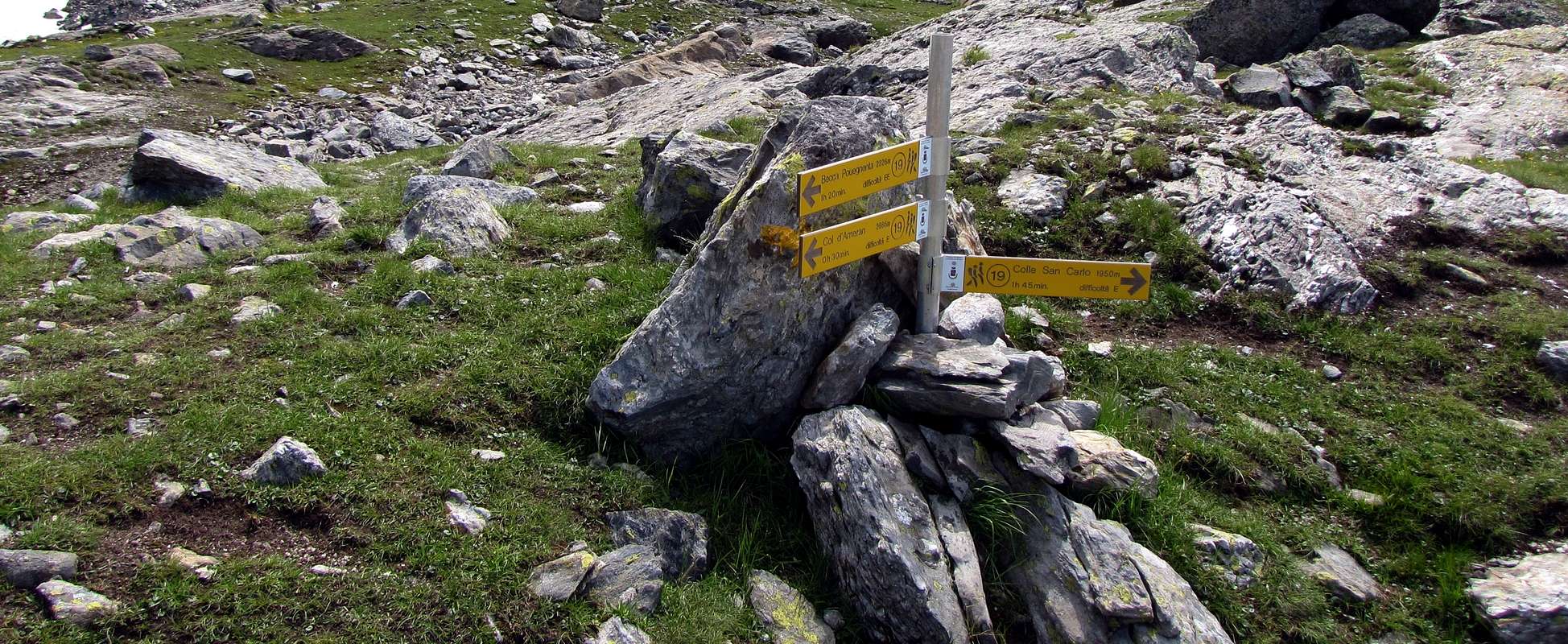 |
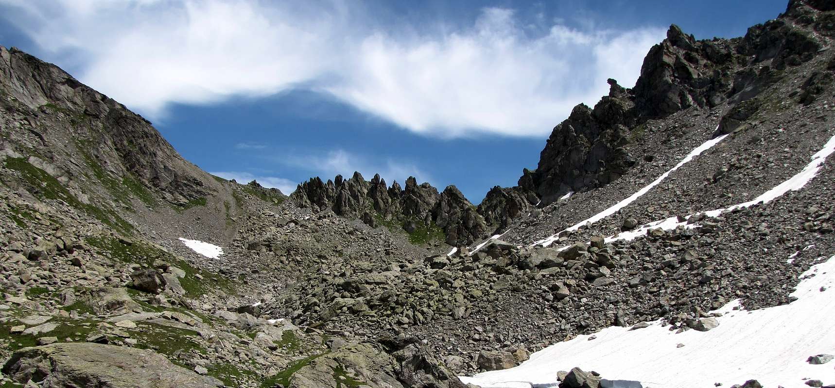
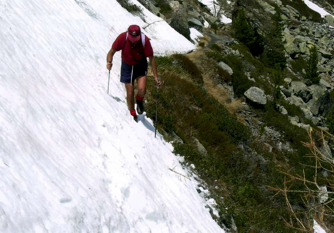
The last appendix "closes" the walloon with its Eastern watershed with adjacent Leseney Vallon: from the Pass of Ameran (connection with the adjacent Leseney small Valley, above the Municipality of Derby 809m) the crest reaches the Summit of the Southern Becca Pouignenta; after overtaking the Central (2.823m), reaches the Northern (2.827m), the highest. From this, with great views of the Central Valley of Dora Baltea, down towards the North to the Passage de Tereza (2.636m) to end with the Mont Charvet (+; 2.489m), just above the Common of Morgex and dominating the bottom of the Conca d'Arpy. This is a zone of easy Hiking, always starting from Arpy Lake, while the area to the South towards the Colle Colmet or Cormet also called of the Comba Sorda (Deaf Basin) requires attention in the path of the minuscule glacier of the same name, but with hidden small crevasses. Finally for the climb to Mont Colmet, from Southeast to the North, you can use the easy ridge that rises from the pass above, the slope Northeast (typically "Normal Route" even for the Ski-Mountaineering) or we will North-northwest Ridge, easy but that requires a bit of experience as exposed in some places.
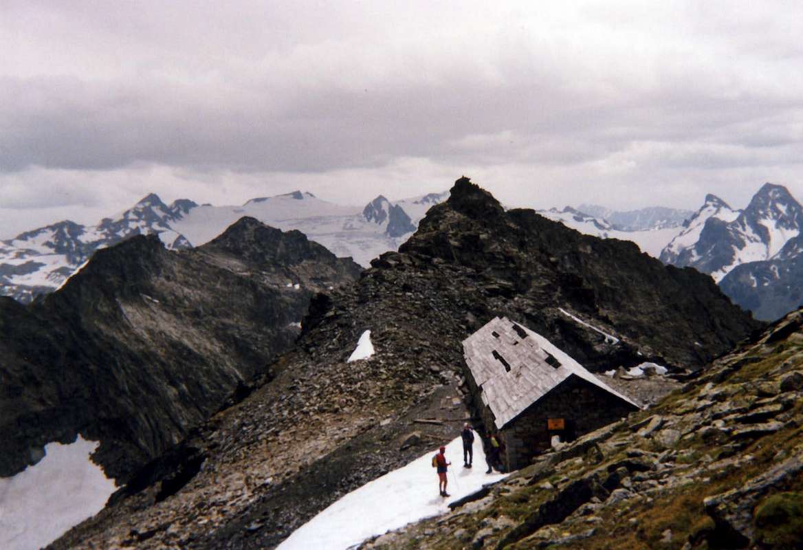
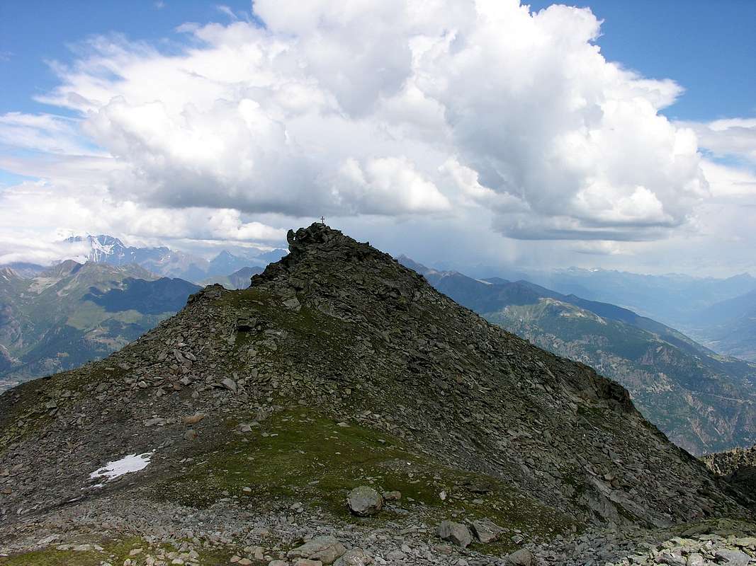
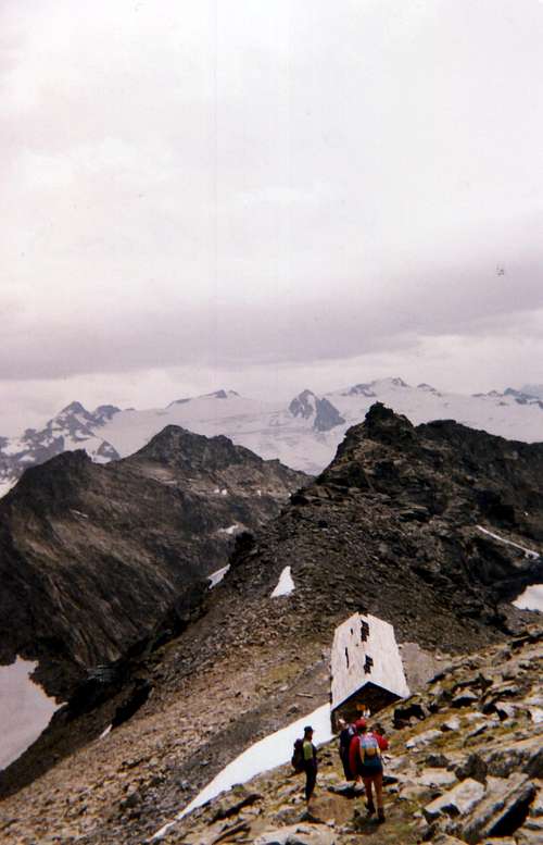
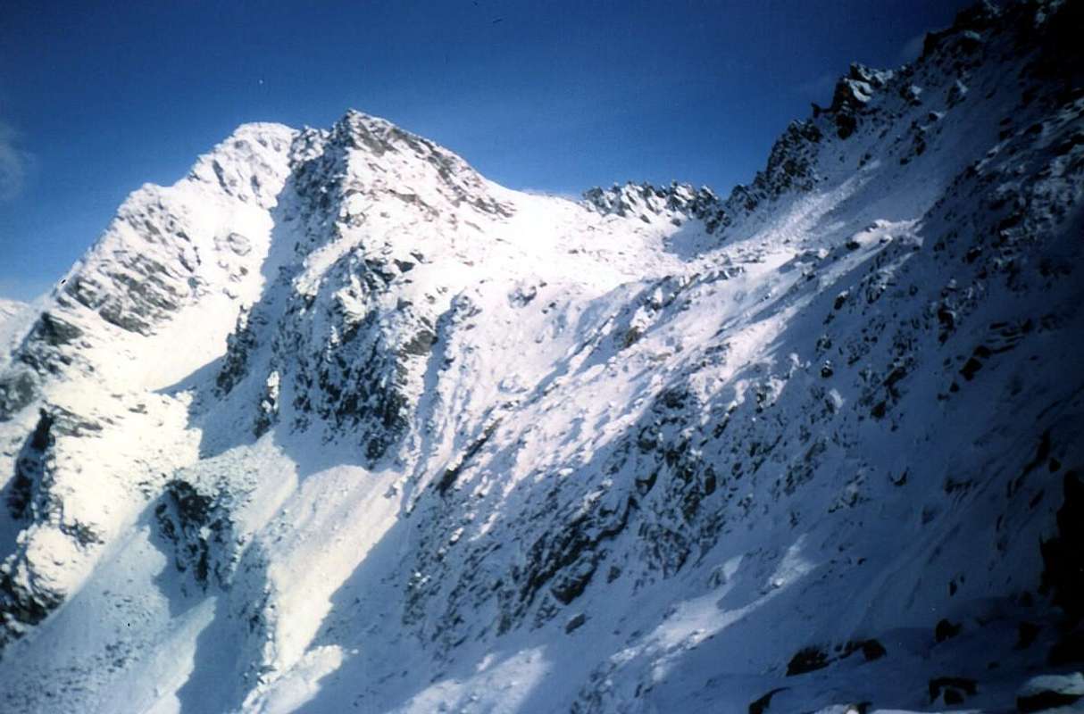
But in this case it is necessary to start from the Colle della Croce (Hill of the Cross), passing over and to the West of Lake Arpy: from the junction 2.000 meters about, almost immediately after the departure from the Colle San Carlo and at the locality St. Maurice, indulges left (East) through the path n° 15 for the Arpy Lake and continue right instead with the n° 16. The same, climbing halfway up, reach the military Shelter Lieutenant Brunet at the Col de la Croix (2.381m). Continues with winding path to the South on the watershed with La Thuile Valley reaching Lieutenant Ticchioni Refuge (2.778m), now at the base of the Ridge North-northwest Mont Colmet. From this point a small trace unnumbered nor indicated "cut" across the Northern Slope of the South Summit Mont Colmet reaching the Lake Pietra Rossa, at its margin Southwest, where also reaches the path trail n° 15 from Lake Arpy and passing over the intermediate plateau with waterfall. Wanting instead to climb the North-northwestern Crest, you follow a small path, reported but not numbered, with tight bends and overcoming some exposed rocky ledges reaches the Northern Summit (3.020m). From this, through a brief descent South, reach the next Barrack Lieutenant Chabloz (2.996m; dangerous being in decay), on a large saddle immediately preceding the turret rocky of Southern Summit (3.024m).
Regarding instead the "Normal Route" customarily used in Ski-Mountaineering (attention because they are also registered misfortunes for the snowslides and avalanches) the same goes with a small trace unnumbered and not even reported that originates from the Southwestern shore of Pietra Rossa Lake. After a short crossing on a narrow slab in a rocky plaque, easy but exposed, you enter a morainic small valley that runs towards the Southwest with two final possibilities:
1) - come out directly to the wide saddle between the two Summit at the old Shelter Lieutenant Chabloz;
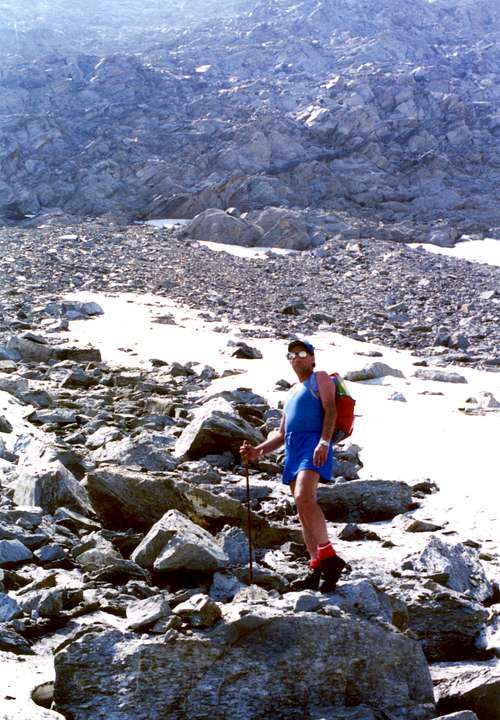
2) - came to about two thirds of the way to abandon this path and, bending decidedly Southwards through a track between large blocks of rock, reaching the big Eastern Shoulder (2.870m), from which easily and quickly to the large saddle. Wanting to reach the South Summit, you must, after a short crossing, bypassing the turret summit through rocks steep but easy (I°/I°+) with enough exposure to La Thuile we reach the same. A third way to Mont Colmet is to start with the way previous to the entrance of the small walloon and then, leaving the same right, continue on a path trail not numbered on the bottom of the main valley up to the Glacier Comba Sorda. Climbed the same margin on its orographic left bank (West) quite easily, overcoming a couple of small crevasses, you will reach the hill of the same name; by this a slight trace goes up between the South Ridge and another secondary on steep and "caotic" Eastern Slope. Follow it until the very end in an area of large "clapeys" (boulders) black-brownish; zigzagging between them you will reach a little fork just South of the tower concluded as in the previous via.
* Remarks:
a) - the description of the three-way has been made in an unusual way for practical need with description in an anti-clockwise from North-northwest to Southeast;
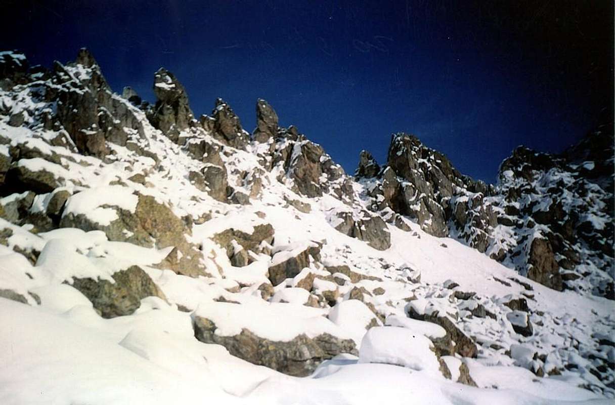
b) - others are not described here as difficult (North Face of North Top climb in only two occasions in June 1939 and in 1992) or dangerous for falling rocks or treacherous path (West, South and East-southeast Slopes) or because simply somewhat unusual although easy (North-northeast Edge, Crest South-southwest by Mountain of the Glacier).
 |
 |
 |
 |
 |
L'ultima appendice "chiude" il vallone con il suo spartiacque Orientale: dal Passo di Ameran (collegamento con l'adiacente Vallone di Leseney, sopra il Comune di Derby 809 m) la cresta raggiunge la Sommità Meridionale della Becca Pouignenta (2.797 m). Dopo aver scavalcato quella Centrale (2.823 m), raggiunge la Settentrionale (2.827 m), la più elevata. Da questa, con grande vista sulla Valle Centrale della Dora Baltea, scende verso Settentrione al Passage de Tereza (2.636 m) per terminare con il Mont Charvet (+; 2.489 m), proprio al di sopra del Comune di Morgex e dominante la parte inferiore della Conca d'Arpy. Questa risulta zona di facili Escursioni, sempre partendo dal Lago d'Arpy, mentre l'area più a Sud verso il Colle Colmet o Cormet oppure anche della Comba Sorda (con discesa verso il Rifugio Deffeyes in Valle di la Thuile) richiede attenzione nel percorso dell'omonimo apparentemente innocuo ghiacciaietto, che però nasconde dei piccoli crepacci. Infine per la salita al Mont Colmet, da Sudest a Nord, si possono utilizzare la facile cresta che sale dal suddetto colle, il Versante Nordest (in genere "Via Normale" anche per lo Sci-Alpinismo) oppure la Cresta Nord-nordovst, facile ma richiedente un pò di esperienza, poiché esposta in alcuni tratti.
In questo ultimo caso però é necessario partire dal Colle della Croce, passando sopra ed ad Ovest del Lago d'Arpy: dal bivio 2.000 metri circa, quasi subito dopo la partenza dal Colle San Carlo e presso la località St. Maurice, si abbandona a sinistra (Est) il sentiero n° 15 per il Lago d'Arpy e si continua invece con quello n° 16. Lo stesso, salendo a mezza costa, raggiunge il Rifugio Tenente Brunet presso il Col de la Croix (2.381 m). Si prosegue con percorso sinuoso a Sud sullo spartiacque con La Thuile raggiungendo il Rifugio Tenente Ticchioni (2.778 m), ormai alla base della cresta. Da questo punto una piccola traccia non numerata e neppur segnalata "taglia" tutto il Versante Settentrionale della Sommità Meridionale del Colmet raggiungendo il Lago di Pietra Rossa al suo margine Sudovest, dove perviene anche la traccia di sentiero n° 15 proveniente dal Lago d'Arpy e passante sopra il pianoro intermedio con cascata. Volendo invece salire per la Cresta Nord-nordovest, si segue un sentierino che, segnalato ma non numerato, con stretti tornantini e superando alcuni piccoli salti rocciosi, ma esposti, ne raggiunge la Cima Settentrionale (3.020 m). Una discesina conduce alla sella tra le due Cime presso la Baracca Tenente Chabloz (2.996 m, pericolosa essendo in disfacimento) e subito appresso alla Cima Sud ((3.024 m).
Per quanto concerne invece la "Via Normale" abitualmente utilizzata anche in Sci-Alpinismo (attenzione perché si sono di già registrate delle disgrazie per slavina o anche valanga) la medesima risale con una piccola traccia non numerata e neppur segnalata originantesi dalla sponda Sudovest del Lago di Pietra Rossa. Dopo una breve traversata su d'una stretta cengia in una placca rocciosa, facile ma esposta, si entra in un valloncello morenico che si percorre verso Sudovest con due possibilità finali:
1) - uscire direttamente alla larga sella tra le due Sommità presso il Ricovero Chabloz;
2) - giunti a circa due terzi del percorso abbandonare questa via e, piegando decisamente verso Sud tramite una traccia tra grandi blocchi, raggiungere lo Spallone Orientale (2.870 m), dal quale facilmente ed in breve tempo alla sella. Volendo raggiungere la Sommità Meridionale, si deve, dopo una breve traversata verso Meridione, aggirare completamente la torretta sommitale e per rocce ripide ma facili (I°/I°+) con discreta esposizione verso La Thuile si raggiunge la stessa. Una terza via al Mont Colmet consiste nell'iniziare con la precedente via fino all'ingresso del valloncello poi, abbandonando la medesima a destra, proseguire su d'una traccia di sentiero non numerata sul fondo del vallone fino al congiungimento con il minuscolo Ghiacciaio di Comba Sorda. Risalito lo stesso sul suo margine orografico sinistro (Ovest) abbastanza facilmente, superando un paio di piccole crepacce, si raggiunge l'omonimo colle; dal medesimo un'esile tracce sale tra la Cresta Sud ed un'altra secondaria sul dirupato e "caotico" Versante Orientale. Seguirla fino a quando la stessa termina in una zona di grandi "clapeys" (grandi blocchi spezzati e "disordinatamente" sovrapposti) nero-brunastri; zigzagando tra gli stessi si raggiunge una forcelletta appena a Sud della torretta concludendo come nella precedente via.
* Note:
a) - la descrizione delle tre vie é stata realizzata inusualmente per esigenza pratica con descrizione in senso antiorario da Nord-nordovest verso Sudest;
b) - le altre non vengon descritte poiché difficili (Parete Nord della Punta Nord salita in due uniche occasioni nel Giugno 1939 e nel 1992) o pericolose per caduta di pietre o dal percorso infido (Versanti Ovest, Sud-sudest ed Est) o perchè semplicemente moltto inusuali pur se facili (Spigolo Nord-nordest e Cresta Sud-sudovest dalla Montagna del Ghiacciaio).
 |
 |
 |
 |
 |
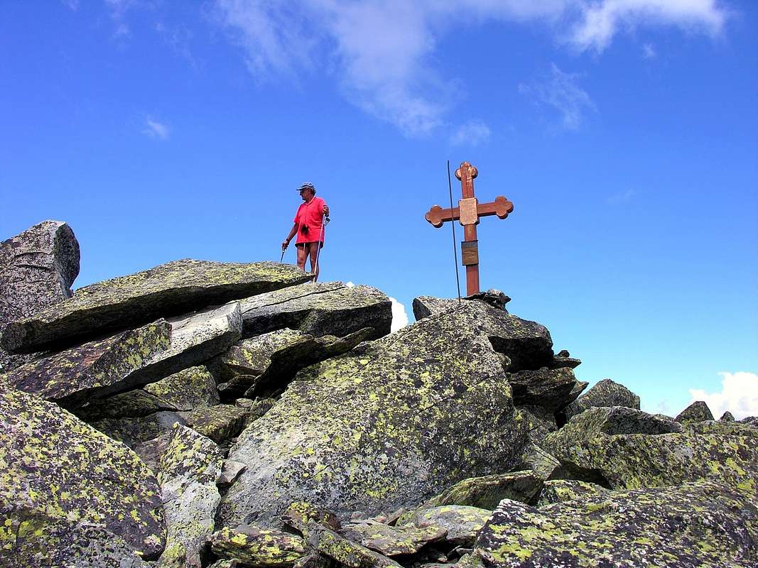
To reach the Pass of Ameran and Becca Pouignenta or Pouegnenta, we must instead circondurre to the West coast of Lake Pietra Rossa and, via the trail n° 19A, passing with semi circular path towards the Northeast through an area of great blocks where often disappears, you reach the Pass of Ameran with a final stretch steeper. The same continues to Northwest along the Southeast Crest through a track unnumbered easily reaching the Southern Summit; from this with a short traverse to the Central and, after a brief descent to a wide saddle, you come to the Summit North (2.827m), the highest, where there is a large Cross. As for the near Colle della Serra (2.736/58m), located at about half the Ridge Ameran and with two steps the most useful of which is the highest, you can hop on a weak track unnumbered, that from the Eastern shore Lake Pietra Rossa goes up for about 220/30 meters up a steep debris channel with blocks and broken rocks. Even the descent on the other side or Leseney is long, and boring free path; agrees in this case, wanting to make the crossing, get off the pitch Ameran always through the path n° 19A and downhill to the East-southeast is transformed into trail n° 20, reaching the Alp of Leseney (2.095m). Finally, as regards the Mont Charvet as there is a way to highlight that part at the entrance of Lake Arpy with marked trail from wooden sign but not numbered. The same joins the trail, also unnumbered, which comes from Fond Arpy Damon Pasture (1.743m). After a long journey to the North-northeast, through numerous furrows torrents, joins him as the common final part is done by a small track that climbs a steep canyon rock-debris, sometimes covered with grass, which ends on the North Ridge at about 250 meters from the Summit; it is reached by means of rocks but very easy routes. In any case inadvisable with both departures. It should instead be Arpy Hamlet (1.680m) follow the private dirt road for Goubelin (1.638m), initially concomitant with the trail n° 15, reaching, bending first toward the Northeast in short descent, the Alpage di Costablinaz Damon (1.470m) and then that of Champex (1.519m). From this last one with the trail n° 10/12/13 towards Southeast to the junction 1.850 meters at the Torrent de la Bouiya; from here to the West with the first route n° 13 until Plan Rançon (2.088m), then to Northwest reaching the Top with the trail becomes a small track on the Slope Southeast. Otherwise you can reach Costablinaz; also directly starting Morgex (923m) or other intermediate points.
MAPS:
Per raggiungere il Passo d'Ameran e la Becca Pouignenta o Pouegnenta, bisogna invece circondurre ad Occidente la sponda del Lago di Pietra Rossa e, tramite il sentiero n° 19A, passando con percorso semi circolare verso Nordest attraversando una zona di grandi blocchi dove spesso scompare, si raggiunge il Passo di Ameran con un tratto finale più ripido. Dallo stesso si continua verso Nordovest lungo la Cresta Sudest per mezzo di una traccia non numerata raggiungendo facilmente la Sommità Meridionale; da questa si attraversa a quella Centrale e, dopo una corta discesa verso un'ampia sella, si perviene alla Sommità Settentrionale (2.827 m), la più elevata, dove esiste una grande Croce. Per quanto concerne il vicino Colle della Serra (2.736/58 m), sito a circa metà della Cresta di Ameran e con due passaggi il più utile dei quali risulta quello più elevato, si può salire su una debole traccia non numerata che dalla sponda Orientale del Lago di Pietra Rossa sale per circa 220/30 metri un ripido canale di detriti, blocchi e rocce rotte. Anche la discesa sul versante opposto o di Leseney é lunga, noiosa e priva di sentiero; conviene in questo caso, volendo effettuare la traversata, scendere dal Passo di Ameran sempre tramite il sentiero n° 19A che in discesa verso Est-sudest si traforma in sentiero n° 20 raggiungendo l'Alpe di Leseney (2.095 m). Infine per quanto riguarda il Mont Charvet da evidenziare come esista una via che parte dall'ingresso al Lago di Arpy con sentiero segnalato da cartello in legno ma non numerato. La medesima si congiunge con il sentiero, anch'esso non numerato, che proviene da Fond d'Arpy Damon (1.743 m). Dopo una lunga traversata a Nord-nordest, attraverso numerosi solchi torrentizi, lo raggiunge mentre la comune parte finale viene effettuata tramite una piccola traccia risalente un ripido canalone roccioso-detritico, a volte ricoperto d'erba, terminante sulla Cresta Nord a circa 250 metri dalla Sommità; la si raggiunge per mezzo di rocce facili ma molto rotte. In ogni caso sconsigliabile con entrambe le partenze. Conviene invece da Arpy (1.680 m) seguire la strada poderale per Goubelin (1.638 m), inizialmente concomitante con il sentiero n° 15, fino a raggiungere, piegando dapprima verso Nordest in corta discesa, l'Alpe di Costablinaz Damon (1.470 m) e poi quella di Champex (1.519 m). Da quest'ultima con il sentiero n° 10/12/13 verso Sudest fino al bivio 1.850 metri presso il Torrent de la Bouiya; da qui dapprima ad Ovest con il sentiero n° 13 fino a Plan Rançon (2.088 m), quindi a Nordovest raggiungendo la Cima col sentiero che diviene una piccola traccia sul Versante Sudest. Altrimenti é possibile raggiungere le Alpi Costablinaz partendo anche da Morgex (923 m) o da altri punti intermedi.
 |
 |
 |
 |
 |
Campings
Remember that free camping is forbidden (except for emergency reasons, over 2.500m, from darkness until dawn).Mountain Condition
- Meteo: you can find all the needed informations at the official site of the Valle d'Aosta Region:
- Valle d'Aosta Meteo
Webcam
- WEBCAM on Aosta Valley:
- Webcam
Books and Maps
BOOKS:- "Guida delle Alpi Occidentali", di Giovanni Bobba e Luigi Vaccarone C.A.I. Sezione di Torino Volume II (parte II), 25 Maggio 1896.
- "Guida dei Monti d'Italia – Alpi Graie Centrali" di Alessandro Giorgetta, Club Alpino Italiano/Touring Club Italiano, 1985.
- "La Thuile e dintorni" di Giuseppe Alliod, Ed. G. Alliod (1994).
- "Valle d'Aosta in Sci", di Rosanna Carnisio, Silvana e Guido Albertella, Ed. CDA Torino, 1993.
- "Pelli di Foca in Valle d'Aosta", di Franco Lenzi Editoriale Pedrini Torino, 1988.
- "Valdigne gli itinerari escursionistici", di Alessandro Giorgetta, Ed. Zanichelli, Giugno 1981.
- "Monte Bianco Valdigne" di Alessio e Giuseppe Nebbia, Ed. Musumeci, (1989).
 |
 |
 |
- Kompass "Massiccio del Monte Bianco Valle d'Aosta Sentieri e Rifugi" Carta turistica 1:50.000.
- Kompass "Gran Paradiso Valle d'Aosta Sentieri e Rifugi" Carta turistica 1:50.000.
- L'Escursionista "La Thuile-Piccolo San Bernardo" Carta dei sentieri (n° 2) 1:25.000.
- Enrico Editore Ivrea-Aosta "Gruppo del Gran Paradiso" 1:50.000.
- I.G.C. Istituto Geografico Centrale Torino "Monte Bianco-Courmayeur-Chamonix-La Thuile" (carta n° 107), 1:25.000.
- I.G.C. Istituto Geografico Centrale Torino "Massiccio del Monte Bianco" (carta n° 4), 1:50.000.
- A.I.A.T. La Thuile, "La Thuile Pianta dei Sentieri", 2004 (Plastico).
- Studio F.M.B. Bologna "Monte Bianco-Mont Blanc" 1:50.000.
- I.G.C. Istituto Geografico Centrale Torino "Il Parco Nazionale del Gran Paradiso" (carta n° 3) 1:50.000.
- Comunità Montana Valdigne Mont Blanc, "Les Sentiers" Edizione 2001, 1:50.000.
 |
Important Information
- REGIONE AUTONOMA VALLE D'AOSTA the official site.
- FONDAZIONE MONTAGNA SICURA Villa Cameron, località Villard de la Palud n° 1 Courmayeur (AO) Tel: 39 0165 897602 - Fax: 39 0165 897647.
- COMPAGNIE DES GUIDES RUTOR Fraz. Entrèves tel/fax 0039.0165.885574 e-mail Guidealpine@lathuile.it
- A.I.NE.VA. (Associazione Interregionale Neve e Valanghe).
Useful numbers
- Protezione Civile Valdostana località Aeroporto n° 7/A Saint Christophe (Ao) Tel. 0165-238222.
- Bollettino Meteo (weather info) Tel. 0165-44113.
- Unità Operativa di Soccorso Sanitario Tel. 118.