


-
 5791 Hits
-
 81.18% Score
-
 13 Votes
|
|
Area/Range |
|---|---|
|
|
45.63050°N / 7.06394°E |
|
|
Hiking, Mountaineering |
|
|
Spring, Summer, Fall |
|
|
Note
La montagna chiama i suoi figli, ed essi rispondono fedelmente al suo appello… Osvaldo Cardellina, Diario alpinistico, 1964-65 Page texts: @ OsvaldoCardellina "Osva", passed away on May 2, 2022. Page owners: Christian Cardellina e Osvaldo Cardellina. Any updates from September 12, 2022: Antonio Giani, page administrator, friend and climbing companion. Testi della pagina: @ OsvaldoCardellina "Osva", scomparso il 2 maggio 2022. Proprietari pagina: Christian Cardellina e Osvaldo Cardellina. Eventuali aggiornamenti dal 12 settembre 2022: Antonio Giani, amministratore della pagina, amico e compagno di salite. |
Overview
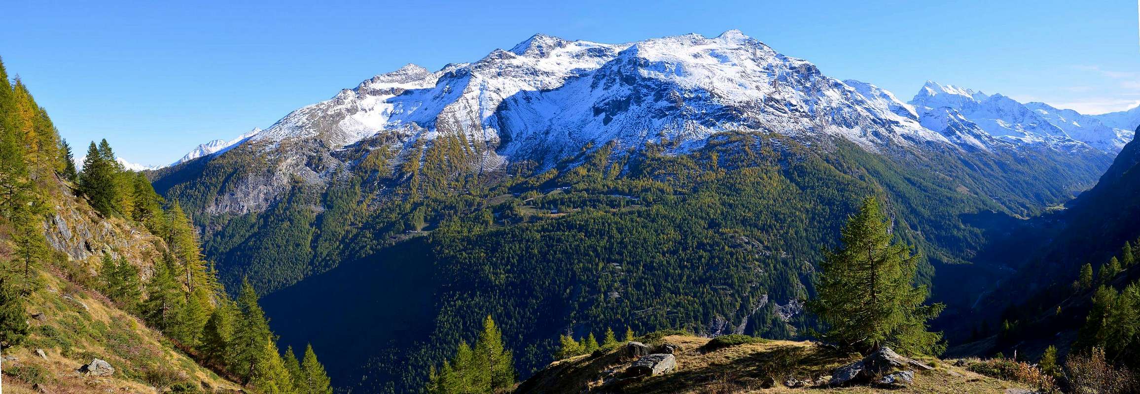
Valgrisenche is one of the thirteen most important valleys of the Valley of Aosta. Located between the Valley of Aosta and Valley of the River Isere in France, bordering the parallel Rhêmes Valley, stretches over 25 km from Li(e)verogne, in the Central Valley of the River Baltea, to its Southern end of the Big Top with high Great Sassière (3.751m). The other valleys, starting from the East and clockwise are: Champorcher, Cogne, Valsavarenche, Rhêmes, La Thuile. Those on the right orographic and hydrographic or South, while on the North will have the Valleys of Ferret and Veny, at the foot of Mount Blanc, Valley of the Great St. Bernard near the Basin By, Valpelline, the Valley of Torrent Marmore or Valtournanche at the top of which stands the Matterhorn and the two valleys of Monte Rosa, or valleys of Ayas and Gressoney. We also have other valleys which, because of their length and extension, such as those of Champdepraz, Fénis-Clavalité and Saint-Marcel, should be treated as such and not like a simple Vallons. Presents 37 important Summits, as many hills and the many glaciers, but mostly unspoiled Nature, who will return even more so after that will be dismantled dangerous Beauregard Dam. This is not a resort "In" or for Mountaineering that for Skiing, even if there are small ski lifts, but rather is a place for lovers of real mountain, one that does not have stupid Indian file for climbing. But it is not so excluded from the world, so he has seen, over the centuries, go to the Col du Mont, Salassians, Romans, Armed French, Spanish Austrian and even Napoleon Bonaparte. His most important peaks are on his Eastern side the Great Rousse, with its two Summit, and other peaks of height between 3.000 to 3.500 meters towards the Subgroup Becca of Tos with other peaks almost completely unknown; while in the West we have the Great Sassière, the Plattes or Pattes ofs Chamoises, Becca of Suessa, the three Ormelune with Archeboc Point, the Grand Becca du Mont and, down below , the Chain Rutor with the small Group of Mount Paramont (3.301m). Once its dead remained not buried until the Spring, when the snow has melted allowed to take them downstream. This was happening a little for all closed and isolated mountain valleys and Valgrisa is a closed valley and isolated. To live up here all year round you have to have a particular zest and be accustomed to talking more with Nature than with men. Leaving out special characters and taciturn, more likely to interview and the inner confidence that no proclamations. This is the "Valgrisenza" ...
 |
La Valgrisenche é una delle tredici valli tra le più importanti della Valle di Aosta. Situata tra la medesima e la Valle del Fiume Isère in Francia e confinante con la parallela Valle di Rhêmes, si allunga per oltre 25 Km da Li(e)verogne, presso la Valle Centrale del Fiume Dora Baltea, fino alla sua estremità Meridionale con l'alta Cima della Grande Sassière (3.751 m). Le altre Valli, partendo da Est ed in senso orario, sono: Champorcher, Cogne, Valsavarenche, Rhêmes, La Thuile. Queste sul lato orografico ed idrografico destro o Meridionale, mentre su quello Settentrionale avremo le Valli di Vény e Ferret, ai piedi del Monte Bianco, la Valle del Gran San Bernardo con vicino la Conca di By, la Valpelline, la Valle del Fiume Marmore o Valtournanche al cui sommo si eleva il Monte Cervino e le due valli del Monte Rosa, ovvero Valli di Ayas e Gressoney. Inoltre abbiamo altre valli che, per la loro lunghezza ed estensione, come quelle di Champdepraz, Fénis-Clavalité e Saint Marcel, dovrebbero essere considerate come tali e non a guisa di semplici valloni. Presenta 37 Sommità importanti, altrettanti colli e numerosi ghiacciai, ma soprattutto una Natura incontaminata, che ritornerà ancora più tale dopo che verrà smantellata la pericolsa Diga di Beauregard. Non é una località "In" né per l'alpinismo che per lo Sci, anche se esistono piccoli impianti; piuttosto é un posto per gli amatori della vera montagna, quella che non presenta stupide file indiane per le ascensioni. Ma non é così esclusa dal mondo, tanto che ha visto, nei secoli, passare per il Col du Mont, Salassi, Romani, Armate Francesi, Austriache Spagnole ed anche Napoleone. Le sue cime più importanti sono sul suo lato Orientale la Grande Rousse, con le sue due Sommità, ed altre cime di altezza tra i 3.000 ed i 3.500 metri fino al Sottogruppo della Becca di Tos con altre vette quasi del tutto sconosciute; mentre ad Occidente abbiamo la Grande Sassière, le Plattes o Pattes des Chamois, la Becca di Suessa, i tre Ormelune con l'Archeboc, la Grand Becca du Mont e, laggiù in fondo, la Catena del Rutor con il piccolo Gruppo del Mont Paramont (3.301 m). Una volta i suoi morti restavano inseppelliti insino a Primavera, quando lo scioglimento delle nevi consentiva di portarli a valle. Ciò che succedeva un pò per tutte le valli alpine chiuse ed isolate e la Valgrisa é una valle chiusa ed isolata. Per abitare quassù per tutto l'anno bisogna aver 'na scorza particolare ed essere abituati a parlare più con la Natura che cogli uomini. N'escon fuori caratteri particolari e taciturni, più propensi al colloquio interiore ed alla riservatezza che non ai proclami. Si tratta della "Valgrisenza" ...
Getting There
BY CAR:
- From Torino, Milano, etc: Motorway A5. Exit in Aosta Ovest. Drive to the near Aymavilles. Follow in the direction of Valle di Cogne.
- From Switzerland: through the Grand St. Bernard Tunnel or the homonym Pass). Drive to Aosta, then follow Courmayeur direction on SS.26. Just after Sarre, turn to the left, in the direction of Valle di Cogne.
- From France: through Mont Blanc Tunnel or Petit St. Bernard Pass). It isn't necessary to enter in Motorway A5, you can drive through SS.26 Aosta direction. Before arriving at the Village of Leverogne, follow the sign and turn right towards Grisenche Valley.
- Aeroporto "Corrado Gex" Saint Christophe (Aosta).
Specific Itinerary Road
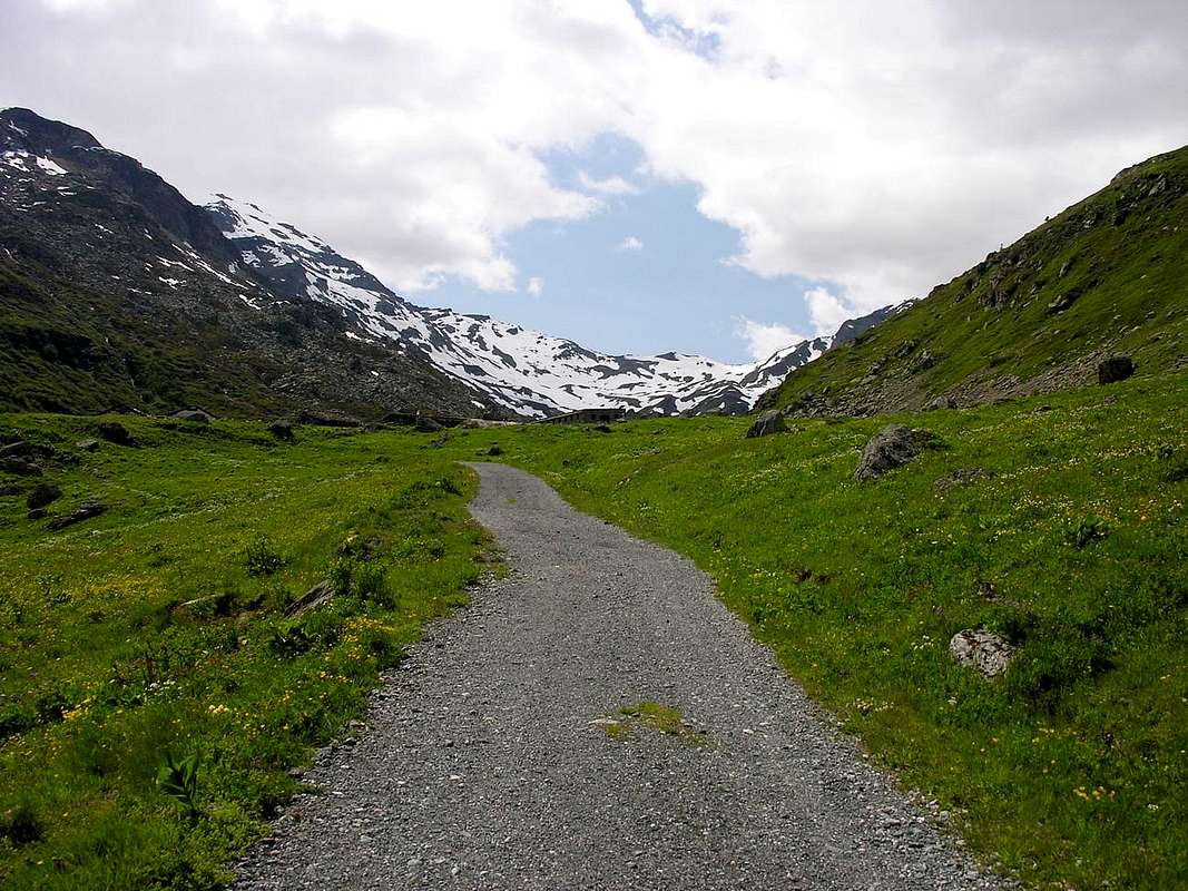
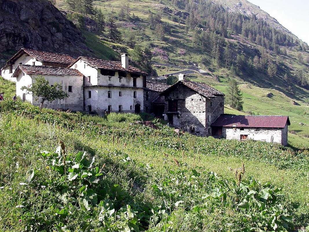
Whether arriving from West to East that (Aosta SS.26 to 15 km) to reach the Hamlet of Leverogne (740m) and with winding road to reach in succession Garin (796m), Ra(e)voire (950m; gym rock) Villages and, with beautiful views to the ruins of the grim Castle Montmajeur sited on hanging rocky promontory, to reach Villages of Chamençon (1.278m), which is left to the East, and Chamin (1.399m), the next Fraction of Planaval mouth of the vallon, is discarded right and continue to the South to the Villages of Revers (1.530 m), Prariond (1.548m), Céré (1.605m) and La Bethaz (1.615m) to finally reach the Chief-lieu of Valgrisenche (1.661m) and the nearby Village of Mondanges (1.652m), just below the front of the Beauregard Dam.
Sia arrivando da Ovest che da Est (Aosta SS.26 a 15 Km) raggiungere il Borgo di Leverogne (740 m) e con stretti tornanti raggiungere in successione Garin (796 m), Ra(e)voire (950 m; palestra di roccia) e, con bella vista sui resti dell'arcigno Castello di Montmajeur sospeso sul soprastante promontorio roccioso, raggiungere i Villaggi di Chamençon (1.278 m), che si lascia ad Est, e Chamin (1.399 m); la successiva Frazione di Planaval (1.557 m), all'imbocco dell'omonimo vallone, si scarta a destra continuando a Mezzogiorno verso i Villaggi di Revers (1.530 m), Prariond (1.548 m), Céré (1.605 m) e La Bethaz (1.655 m) pervenendo infine al Capoluogo di Valgrisenche (1.661 m) e la vicina Frazione di Mondanges (1.652 m), proprio sotto il fronte della Diga di Beauregard.
 |
 |
 |
 |
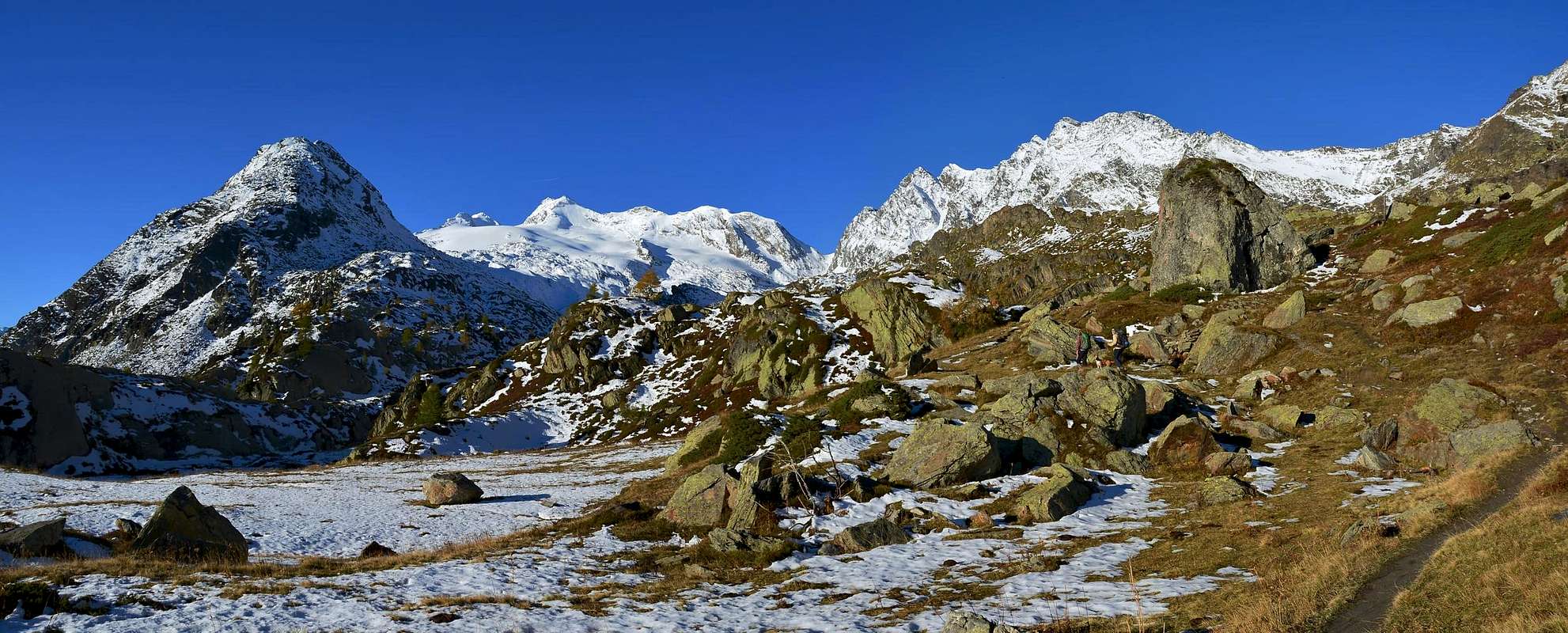
The Valgrisenche Valley
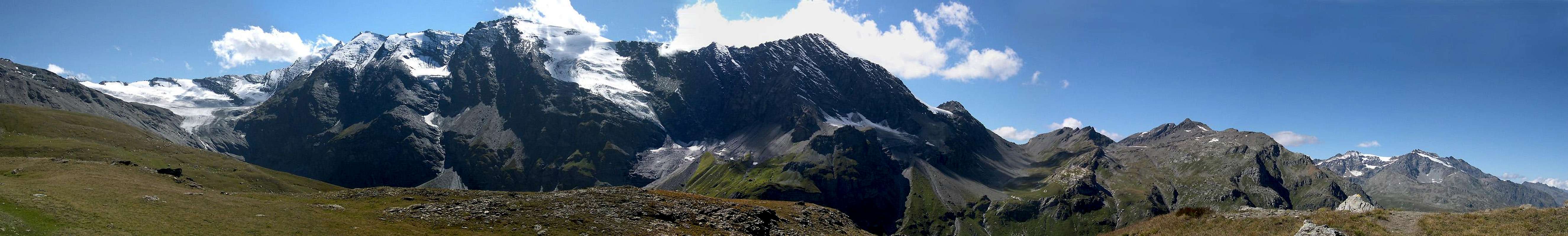
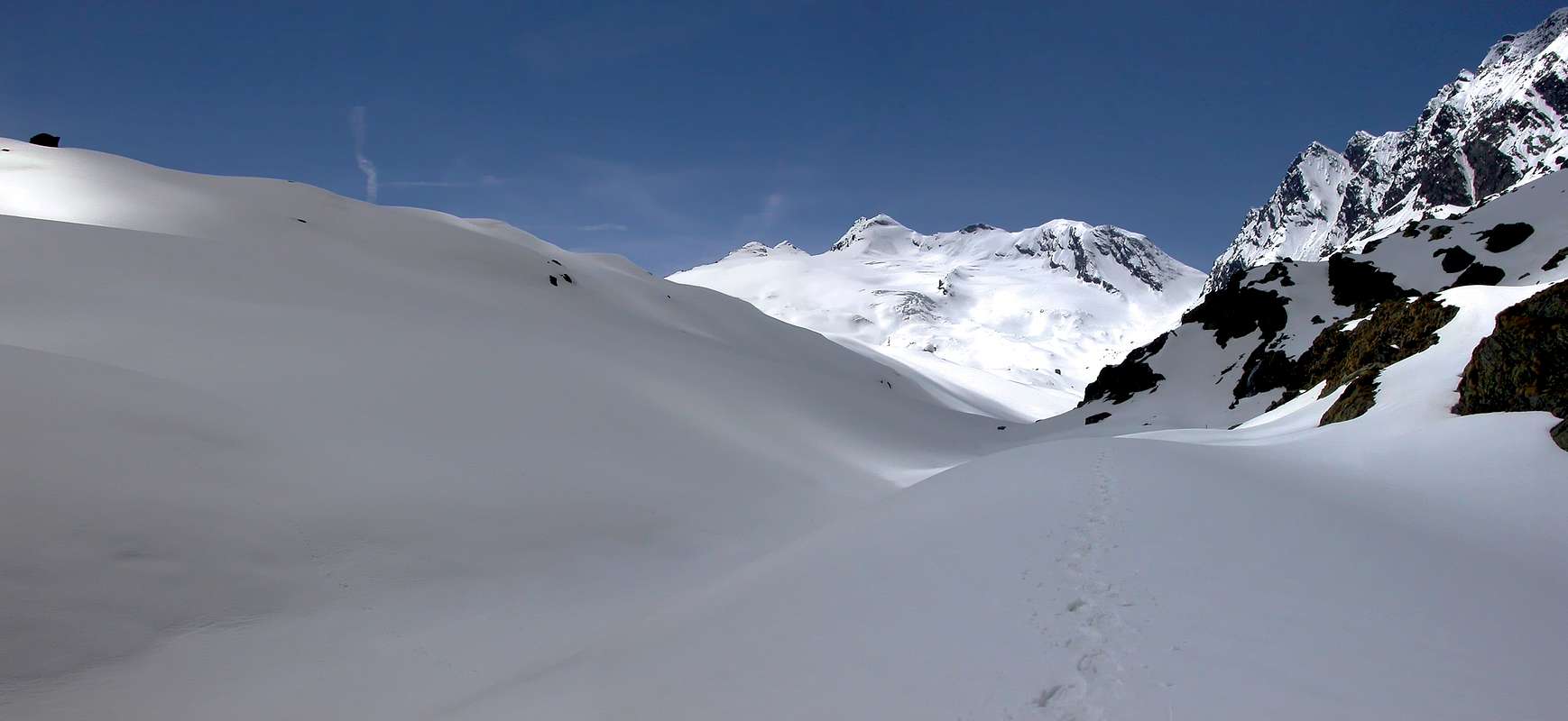
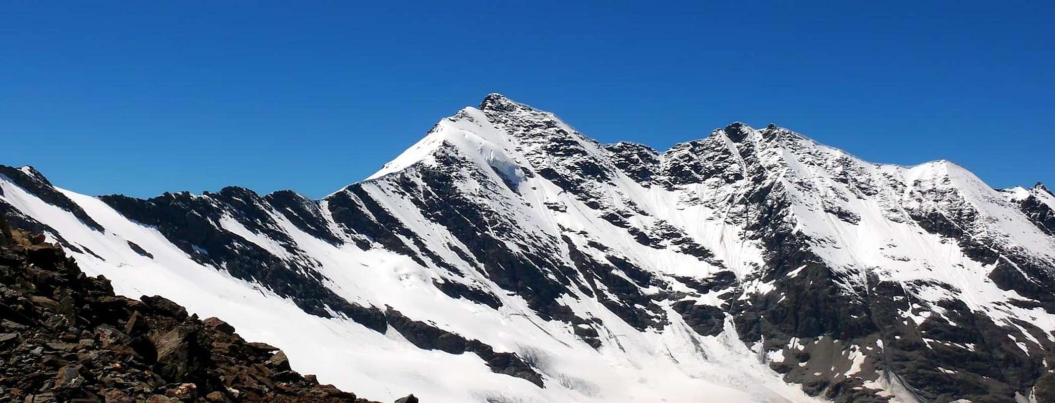
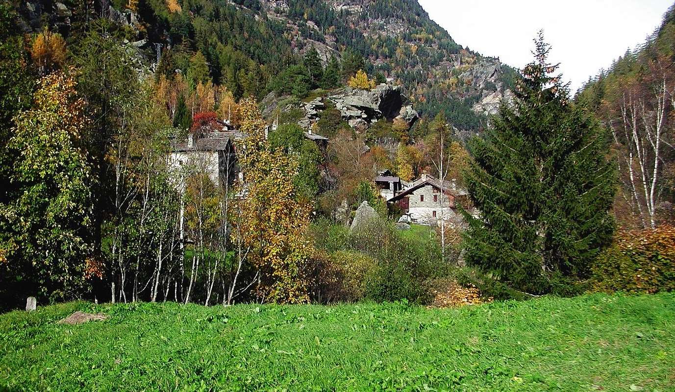
Valgrisenche spanning over 25 km until the border with Valdisère and wide from 3 to 10 at its highest point is the "Grey" Valley, perhaps to emphasize the always cool or cold temperatures fueled by the winds that come from the Great Sassière (3.751m), maximum peak of the valley, but also the highest elevation between the Gran Paradiso (4.061m) and the Group of Mount Blanc (3.817m Aiguille des Glaciers), but in fact it is also and above all a green valley, where this color abounds everywhere from the grasslands of the plains to the edge of the its glaciers. Takes origin from the Hamlet of Leverogne or Liverogne (L'Eyvies or Waters "mangy", that impetuous) South of Baltea Stream and salt winning one bastion below the Tower of Montmay(j) or Mont Mayeur, also known as the Tower of eur Arboé or Haury and yet told of Anry, famous for its horrifying legends ( from the rock were thrown the hated enemies or sentenced horrid below), then, before, the valley is wedged in the course of the homonymous Dora and, after, progressively opening in a plain, which starts offering views of the Group Rutor. Leaving on the right (West) on the great Vallon of Planaval-Fond continues more open and, after several villages, reaches Valgrisenche, its Chief Town at the foot of the Dam Beauregard, being closed to the danger due to landslides on its slopes. Remains of its waters still bury the old Village Fornet, once the center of life fruitful and where bread was cooked twice in each year; the new Fornet (1.726m) was then built just upstream the tributary of artificial lake. Two side streets surround it: the first fraction from the salt on his Eastern side of Mondanges Fraction is currently closed to traffic for these reasons; over reigns the Grande Rousse with its surroundings The second runs along the opposite side to reach the small Villages of Bonne and Menthieu and then dropped to Surrier/Us(s)ellières, where he started on the path to Refuge Mario Bezzi at Vaudet Alp (2.284m), located at the foot of the Glacier Glairetta and in front of the Great Sassière. They say that this mountain is the most scenic of the Aosta Valley and see that from his Top 230 glaciers and mountains over 1.000 (Mario Aldrovandi in "Guida della Regione Autonoma della Valle di Aosta", pagina 317; Edit. Fanton Turin 1964). Are 37 or 60 thus adding those that become less important, instead, the peaks that rise above its vallons. Among these are those who cite the Refuge Epée and the overlying Ravelli Bivouac at the edge of the Glacier of Mount Forciaz Fortchat or, at the foot of the Northern and Western slopes of the Great Rousse, North Point, the most right round up the two Glaciers of th'Invergnaou and Giasson, below the long ridge that reaches from the summit of the same name Becca. Important crossings, such as the Col du Mont, mark the passage over the centuries to France, and to Valley Thuile Pass Planaval at the foot of the Mount Paramont Group, shows a way as high as long that leads to the Refuge Albert Deffeyes, before the Glaciers Rutor. Opposite crossings lead to internal Rhêmes, including the Fenetre de Torrent which bypasses the divider between Grande Rousse and Point of Rab(o)uigne which passes on the Alta Via n° 2 of the Aosta Valley joining Rhêmes Valgrisenche. Other passes combine these two parallel valleys, such as those of Bassac Déré and Bassac easy enough crossing, in the South, while those in the North of Cussuna, Feleumaz and Tzaboc are certainly roughest; then it's all the territory of the hunters more and more "marginalized", fortunately, to the borders of the West P.N.G.P. that arriving until the Dora Rhêmes. To find another way of connecting, you must use the long road leads diagonally from fractions of Rhêmes towards the watershed catching Maison Cou (2.219m), under the Mont de l'Ane, before falling to the top of Valgrisa above the Villages of the Pileo, Grand'Haury, with its horrific tower, and Les Combes (1.323m), of which we will say just ahead. At the bottom of the head and those of Sassière and of Fond lead in Valdisère, but does require the crossing of glaciers not simple and fairly dangerous. Home to the ancient settlements with magnesite mine, showing his long climb medieval bridges, a chapel in 1400 in the locality of Verconey and many waterfalls including one worth noting is the Miollet, above Céré Village. In recent decades it has been chosen by two Popes John Paul II° and Benedict XVI°, who have chosen as the location for their summer vacation home to the Village of Les Combes, at the foot of Becca of Merlo or Chamin.
 |
La Valgrisenche lunga oltre 25 Km fino ai confini con la Valdisère e larga da 3 a 10 nel suo punto massimo è la Valle "Grigia", forse a sottolineare le temperature sempre fresche o fredde alimentate dai venti che provengono dalla Grande Sassière (3.751 m), massima vetta della valle, ma anche maggior elevazione tra il Gran Paradiso (4.061 m) ed il Gruppo del Monte Bianco (Aiguille des Glaciers 3.817 m); in realtà é anche e soprattutto una valle verde, dove questo colore ovunque abbonda dalle praterie della piana insino ai margini dei suoi ghiacciai. Prende origine dal Borgo di Leverogne o Liverogne (L'Eyvies od appunto Acque "rognose", cioé impetuose) a Sud della Dora Baltea e sale vincendo uno spalto sottostante la Torre di Montmay(j)eur o Mont Mayeur, detta anche Torre di Arboé o di Haury ed ancor d'Anry, famosa per le sue raccappriccianti leggende (dalla rupe venivano gettati gli odiati nemici od i condannati nell'orrido sottostante); poi la valle dapprima s'incunea presso il corso della omonima Dora ed indi va progressivamente dischiudendosi in una piana, che inizia ad offrire viste sul Gruppo del Rutor. Lasciato sulla destra (Ovest) il grande Vallone di Planaval-Fond, prosegue più aperta e, superati diversi villaggi, raggiunge Valgrisenche, suo capolugo ai piedi della Diga di Beauregard, in fase di chiusura per la pericolosità dovuta a franamenti sui suoi versanti. I resti delle sue acque seppelliscono ancora l'antico Villaggio del Fornet, un tempo centro di vita feconda, ove si cuoceva il pane due volte all'anno; il nuovo Fornet (1.726 m) é stato poi costruito appena a monte dell'immissario del lago artificiale. Due strade laterali la contornano: la prima che dalla Frazione di Mondanges sale sul suo fianco Orientale attualmente é chiusa al traffico per i suddetti motivi; al di sopra regna la Grande Rousse con il suo circondario. La seconda percorre il lato opposto raggiungendo i piccoli Villaggi di Bonne e Menthieu per poi scendere a Surrier/Us(s)ellières, dove ha inizio il sentiero per il Rifugio Mario Bezzi all'Alpe Vaudet (2.284 m), posizionato ai piedi del Ghiacciaio di Glairetta e di fronte alla Grande Sassière. Dicon che questa montagna sia la più panoramica della Valle di Aosta e che dalla sua Cima si vedan oltre 1.000 montagne e 230 ghiacciai (Mario Aldrovandi in "Guida della Regione Autonoma della Valle di Aosta", pagina 317; Edit. Fanton Torino 1964). Son 37 che diventano 60 assommando quelle meno importanti, invece, le Vette che s'alzano al di sopra dei suoi valloni. Tra questi abbiamo quelli che adducono al Rifugio dell'Epée ed al soprastante Bivacco Ravelli al margine del Ghiacciaio di Mont Forciaz o Fortchat, ai piedi dei Versanti Settentrionale ed Occidentale della Grande Rousse, Punta Nord; più a destra completano il quadro i due Ghiacciai dell'Invergnaou e del Giasson, sottostanti la lunga cresta che dalla Vetta raggiunge l'omonima Becca. Valichi importanti, come il Col du Mont, segnano nei secoli il passaggio verso la Francia, mentre verso la Valle di Thuile il Passo di Planaval, ai piedi del Gruppo del Mont Paramont, indica una via tanto alta quanto lunga che conduce al Rifugio Albert Deffeyes, prima dei Ghiacciai del Rutor. Sul lato opposto valichi interni portano a Rhêmes, tra i quali la Fenetre de Torrent che scavalca il divisorio tra Grande Rousse e Punta Rab(o)uigne sul quale transita l'Alta Via n° 2 della Valle di Aosta congiungendo Rhemes a Valgrisenche. Altri colli uniscono queste due vallate parallele, come quelli di Bassac Déré e Bassac con abbastanza facile attraversata, a Mezzogiorno, mentre a Settentrione quelli di Cussuna, Feleumaz e Tzaboc sono sicuramente più impervi; poi é tutto territorio dei cacciatori sempre più "emarginati", fortunatamente, ad Occidente dai confini del P.N.G.P. che arriva fino alla Dora di Rhêmes. Per trovare un'altra via di collegamento si deve utilizzare la lunga e vecchia mulattiera risalente in diagonale dalle frazioni di Rhêmes verso lo spartiacque raggiungendolo a Maison Cou (2.219 m), sotto il Mont de l'Ane, per poi discendere all'inizio della Valgrisa sopra i Villaggi del Pileo, Grand'Haury, con la sua orrifica torre, e Les Combes (1.323 m), della quale diremo appena più avanti. In fondo alla testata quelli della Sassière e del Fond conducono in Valdisère, ma richiedono l'attraversamento non semplice di piuttosto pericolosi ghiacciai. Sede di antichi insediamenti con miniera di magnesite, mostra lungo la sua salita ponti medioevali, una cappella del 1400 in località Verconey e tante cascate tra le quali si evidenzia quella del Miollet cascante sopra al Villaggio di Céré. Negli ultimi decenni é stata visitata dai due Papi Giovanni Paolo II° e Benedetto XVI°, che hanno scelto come località per le loro vacanze estive la sede del Villaggio di Les Combes, ai piedi della Becca del Merlo o di Chamin. ![]()
SUMMITS Succession from Becca of Traversière to Becca of Tos/Becca of Verconey Subgroups at the end of the watershed South/North between Rhêmes/Valgrisa Valleys
The Mountains
The mountains can be divided into two distinct groups: those located on the orographic right side or on the Eastern watershed Valgrisa/Rhêmes, those on the West between Valgrisa/ Val d'Isere in the first section or between Valgrisa/La Thuile in the second half. The district is closed to the South by the head of the valley, marked by the two passes East and West of Sassière, forms the crest of the French border from spout Traversière and coming to the Great Sassière.
Becca della Traversière (3.337m) - Quota Unnamed 3.191 meters - Pointe Bassac Déré (3.352m) - Pointe Bassac South (3.461m) - GRANDE TRAVERSIERE (3.496m) - Pointe de Bassac North (3.387m) - Truc Blanc (3.405m) - Cime di San Martino (3.363m, 3.341m) Group.
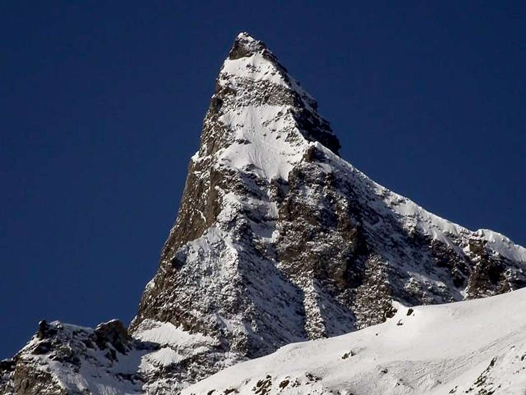
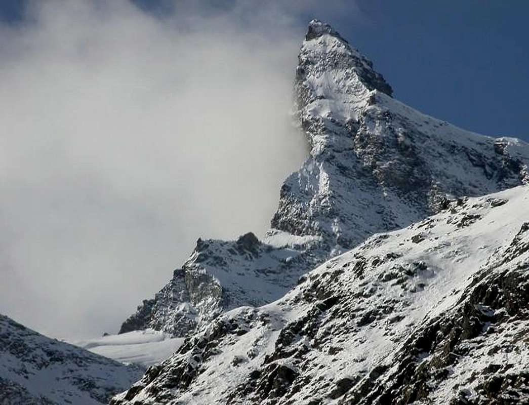
To Northwest Becca di Giasson (3.127m) small Subgroup. To North-northeast Pointe de Barmaver(a)in (3.472m) - Punta Tina (3.523m) - Grande Rousse South (3.552m) small but large Subgroup. To Southeast Becca di Fos (3.457m). GRANDE ROUSSE NORTH (3.607m) - Pointe de Rabuigne (3.261m) Group.
To East Mont Forciaz or Fortchat Oriental (3.244m) and Occidental (3.185m) small Subgroup. To North-northeast Cime de Bouque or Boucs (3.107m) - Becca di They (3.186m) - Becca Laugier or Becca de Changier (3.076m) to Southeast. Becca di Pré d'Amont or Praz-Damon (3.234m) - Punta di Feluma or Feleumaz (3.213m) - Pointe de la Louetta also Becca de Tz(s)aboc (3.214m) Subgroup. To North Quota Unnamed 3.275 meters - BECCA di TOS (3.301m) - Grand Revers (3.164m) - Becca del Merlo or dù Chamin (2.961m) - Mont de l'Âne (2.361m) - Creu de Bouque (+; 1.711m) Subgroup. To North-northwest Becca Verconey (2.925m) small Subgroup.
Le montagne si possono dividere in due distinti gruppi: quelle posizionate sul lato orografico destro od Orientale sullo spartiacque Valgrisa/Rhêmes; quelle sullo Occidentale tra Valgrisa/Val d'Isère nel primo tratto o tra Valgrisa/La Thuile nella seconda parte. Il circondario viene chiuso a Mezzogiorno dalla testata della valle che, segnata dai due Colli Est ed Ovest dell Sassière, forma la cresta di frontiera con la Francia a partire dal Becco della Traversière ed arrivando alla Grande Sassière.
SUMMITS Succession from Great Sassière to Mount Colombo Group at the end of the watershed South/North between Valgrisa/Val d'Isère/La Thuile Valleys & Dora Baltea Vallons
GRANDE SASSIERE (3.751m) - Petite Sassière (3.672m) - Pointe Nant Cruet (3.610m) - Pointe des Plattes or Pattes des Chamois (3.567m) - Becca di Suessa also Schuetse (3.423m) - Becca de Pertcha (3.028m) - Pointe de Serrù or de Maurin (3.227m) - Mont Quart (2.790m) Group. To Northwest MONT ORMELUNE (Southeast also Pointe du Soudzei (3.256m), Central Ormelune (3.230/1m) and Northwest or Pointe de l'Archeboc 3.278m) - la Rocher Brune (2.720m) - Bec de l'Ane and Gran Becca du Mont (3.158m, 3.209m) - Arête du Loydon (3.172m) Group.
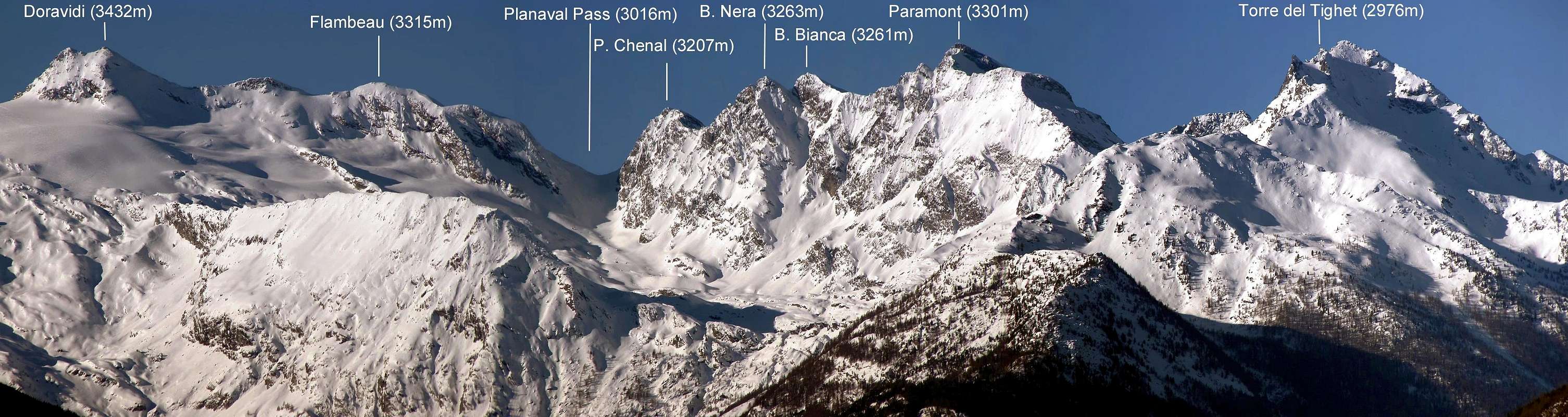
To North-northeast Becca du Lac (3.405m) - TESTA del RUTOR (3.486m) - Château Blanc (3.406m) - Doravidi (South 3.432m and North 3.441m) - Flambeau (3.315m) - Pointe Chenal (3.207m) - Punta Nera (3.262m) - Punta Bianca (3.361m) - Petit Paramont (about 3.255m) - MONT PARAMONT (3.301m) Subgroup.
To Norteast Mont Pit (2.814m) - Pointe de la Crosatie (2.933m) - Monte Valletta (2.521m) - Mont Brolliat (2.352m) small Subgroup. To East Bec Taillà (2.983m) - Tour du Tighet also Tignet (2.976m; Mont Large (2.213m) to Northeast, small watershed between Tillac/Crétaz Vallons, then out of the Valgrisenche as well as Monte Valletta and Mont Broillat) - Pointes de Faveroy (Southwest about 2.230/40m and Northeast about 2.200/10m) - Torre Tonda (2.583m) - Monte Colombo (1.841m) Subgroup.
 |
The passes
There are many hills and steps that lead to Valgrisa or by the same lead in Rhemes, Val d'Isere and La Thuile, we counted a total of 27, of which 10 with Rhêmes, 8 with France, 5 towards La Thuile and 4 with the high walloons to the South above Baltea River. Of all these steps, in reality, few have been used by the inhabitants of the three valleys, being generally of the cross for the purpose of hunting or mountaineering. To think that the inhabitants of Valgrisa to travel to Val d'Isere are routinely passed through the Passes of Sassière, with the greatest extension of the glaciers of the time and its dangers, is pure folly, this does not mean that someone is not passed, but there to the fact of seeing a continuous line of communication is neither in heaven nor on earth. So that is also easy for the two hills of the Bassac Déré and Bassac that, while not difficult transit would require a "circumnavigation" tremendous between Valgrisa and Rhêmes Notre Dame Hamlets. The same considerations apply to all packages of the coastal Rutor from that of Saint Grat, between the same and Becca of Lac, to those, in succession, the Rutor, Château Blanc, Doravidi and up to one Planaval, this last, perhaps, possessed a sense of connection between the pastures of Fond Ussellettes and those in the Valley of La Thuile. All the others were occasional passing and more from experienced hunters that villagers in transit. Otherwise you should see the cows with crampons on feet.
Molti son i colli ed i passi che portan alla Valgrisa o dalla medesima conducono a Rhêmes, Val d'Isère e La Thuile; ne abbiamo contati complessivamente 27, dei quali 10 con Rhemes, 8 con la Francia, 5 con La Thuile e 4 con gli alti valloni a Sud e al di sopra della Dora Baltea nella Valle Centrale. Di tutti questi passaggi, in realtà, pochi son stati utilizzati dagli abitanti delle tre vallate, essendo in genere delle attraversate a scopo di caccia od alpinistiche. Pensare che gli abitanti della Valgrisa per recarsi in Val d'Isère siano abitudinariamente passati per i Colli della Sassière, con la maggiore estensione dei ghiacciai d'allora e relativa pericolosità, é pura follia; questo non vuol dire che qualcuno non sia transitato, ma da lì al fatto di veder una via di comunicazione continua non stà nè in cielo né tanto meno in terra. Così vale anche per i due facili Colli del Bassac Déré e di Bassac che, pur di non difficile transito, richiedon una "circumnavigazione" tremenda tra i Borghi di Valgrisa e Rhêmes Notre Dame. Le stesse considerazioni valgon per tutti i colli della costiera del Rutor da quello di San Grato, tra lo stesso e la Becca du Lac, a quelli, in successione, del Rutor, Château Blanc, Doravidi e fino a quello di Planaval; quest'ultimo, forse, possedeva un significato di legame tra gli alpeggi del Fond e quelli di Ussellettes in Val di La Thuile. Tutti gli altri erano di occasional passaggio e più da cacciatori esperti che per valligiani in transito. Altrimenti si dovrebbero veder mucche coi ramponi alle zampe. ![]()
VALLONS In order to deploy clockwise from Les Combes Basin to Fond-Planaval Vallon
~~~~~~
The glaciers
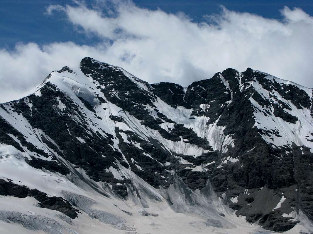
At the foot of the Great Sassière, and between this and the spout Traversière to the east and near the Bassac Déré Hill (3.082m), extends the Glacier of Glairetta, which joins the West with that of Vaudet under the great Wall North-north-east of the same and lapping the sides of the Petite Sassière East (3.672m) at its end ogle three tiny lakes (2.905, 2.885m), witnessed his gradual withdrawal, while threatening his infernal roar cauldrons with swirling, noisy windings waters between the dark and polished rocks (the famous "Exhausts or Mufflers of the Sassière"). From the Bassac Déré towards the North stretch into the valley and the two small twins Glaciers of Bassac Déré, followed in parallel to that of Bassac below the beautiful Grande Traversière (2.496m) over which passes the path that crosses the Bassac Hill (3.154m), combines the Refuge Mario Bezzi with Barmaverain-Saint Pantaleon and Thumel (1.879m), at the end of the road that goes from Rhêmes Notre Dame. Further North we find the tiny Glacier of Saint Martin, nestled between the North of Punta Bassac and Col du Truc Blanc, much less passable previous two, but you have to cross the Col de Fos next to find most other glaciers extended. From the district of Becca di Giasson at Northern Point Grande Rousse relax Glacier Giasson, of Invergnaou and Mount Forciaz, the first two welded together along the base of the partition that the Summits of Saint Martin salt until two of the Grande Rousse, however, remains to Fortchat, with clear signs of gradual withdrawal over the Bivouac Ravelli, lonely and "squatting" at the base of the North Face. More than two Mounts Forciaz or Fortchat will raise the Glacier des Bouc or Bouque that goes up to the Summit of the bully Rabouigne (3.261m) with the North-northwest Face, classic Ski-mountaineering on which has already been a great misfortune because avalanche; in the small valley to the left (West) accompanies the narrow Glacier de l' Epee but does not have the strength to reach the Summit of Mont Forciaz West (3.244m), "dying" between the two to a large round saddle. From this point it no longer watershed glaciers more than three Km to the Glacier Luetta place between the Point Feleuma(z) and the Point Luetta or Becca of Tzaboc, one last Glacier Tos cloaked the Northern slopes of the homonymous Becca (3.301m), this classic of the Ski-mountaineering and certainly less dangerous, and concludes the divide Valgrisa/Rhêmes. On the opposite side, after that of Vaudet, we find the Glacier of Point Plattes des Chamois or Pattes of Chamoises that, he also classic Ski-climbing, descends steeply to the Northeast threatening above Lake Vert (2.620m) and looming on the refuge, another well-smaller glacier of Schuetse or Suessa, stretches from South to North between Becca same name and Vaudet Hill (2.836m), easily traversable. Then you have to overcome more than a kilometer to reach the three glaciers, which descend parallel to the Northeast, to Suzei, Ormelune and Archeboc, these are the classic ski mountaineering. Past the famous Col du Mont find at the foot of Grand Becca du Mont or Bec de l'Âne, the miserable remains of the Glacier Sachère whose waters are poor but still generous, supplying the beautiful Lake Saint Grat (2.462m) to the the basis of the Southern Slopes of Becca of Lac and the Testa of the Ru(i)tor. Formed this loop, the watershed is transformed from Valgrisa/Val d'Isère to partition with the Valley of La Thuile and its extensive glaciers; side Valgrisenche instead are arranged in parallel and turned to the East of the Glaciers Morion, smaller, and Château Blanc (another classic) axis lying South/North until Planaval Pass. Beyond the ridge is rocky and without glaciers dating back to Mount Paramont and ends with the rocky-wooded slopes of Monte Colombo, above the Central Valley.
The vallons
 |
Valgrisenche Valley & surroundings Les Combes Vallon: from Grand Haury (1.197m) to Les Combes (1.323m) and in Southwest Combientse (1.783m), Plan Bry (1.918m), in Southeast Maison Crou (2.219m), with paths; from this through North-northeast Ridge Mont de l'Ane (2.361m), Cross 2.439 meters, with traces, below Quota 2.690 meters and, through North Crest Becca of Merlo also of Chamin (2.961m), with debris, traces and small rocks, with snow rope required. Tos Vallon: from main road to Valgrisenche alternative to Chamençon (1.236m), Chamin (1.399m), Boregne (2.000m) Villages, with farms dirt road; from this in Southeast into Tos Vallon , pond 2.812 meters, Tos Glacier to North Face of Tos Becca (3.301m), classic ski-mountaineer route.
Maison Forte Vallon: from Gerbelle (1.621m), Chez-Garral (1.621m), Planté (1.656m), la Frassy (1.658m), with municipal road; after dirt road to to Upper Verconey (1.980m), Maison Forte (2.365m) Alps. From this in South
1) - small saddle (2.695m), between Becca de Quatre Dents (2.640m) and Testafochi Shelter (2.695m); in East Feleuma Point (3.213m), through easy East Ridge. In East
2) - wild vallon to Tzaboc Pass (3.082m), through moraines and snowfields; in South
3) - Luetta also Tzaboc Point (3.214m), by rocky Northeast Crest rope required, one exposed passage of II°.
Plontaz-Pré Damon Vallons: from road Valgrisenche Dam Eastern shore to Prariond (2.039m), Pra Londzet (2.184m), Mandaz, Plontaz (2.303m), Bruille Pastures, with farms road. From Plontaz in Northeast to
1) - Testafochi Shelter; in East-northeast to
2) - Feleuma Pass (3.001m), paths. In East to
3) - Becca of Pré Damon (3.234m), directly through traces on grassy along small torrent, moraine and West easy slope with small rocks and a little traverse (15 metres, I°+). From Bruille to East
4) - Cussunaz Pass, path.
5) - Descent to Chanavey (1.696m) Village in Rhemes Valley.
l'Epée Vallon:
1) - from Pra Londzet Pasture (2.184m) in South, fork 2.220 meters, Chalet de l'Epée (2.377m), path. From shelter in East to
2) - Fenetre de Torrent Pass, with path;
3) - descent to Notre Dame in Rhêmes Valley, steep trace and following path.
4) - in Southeast Point Rabuigne or Eastern Mount Forciaz (3.261m), with moraine along small brook, Bouque Glacier and North Face (30°/37°), classic Ski-mountaineering.
Comba Vaudet-Grapillon: from Refuge Mario Bezzi (2.284m) Northwest direction with paths to Grapillon Torrent, Vaudet or Suessa Hill (2.836m).
Comba du Rocher Blanc: from Refuge Bezzi to Grapillon Torrent, Quota 2.617 meters with path and after by traces to Lake Noir Pass (2.872m).
Col du Mont Vallon: from Rognettaz Desot (1.990m) to Grand'Alpe (1.988m), fork 2.174 meters in Saint Grat Vallon, Mont Hill (2.639m).
Saint Grat Vallon: from fork 2.174 meters in North Lac Torrent to St. Grat Chapel/Loch (2.462m); from this, by traces, to Sachère Pass (2.841m).
Orfeuille Vallon: from Planaval Village (1.557m) through municipal road to Orfeuille Hamlet (1.985m), Plan Petet small Village (2.284m); from this
1) - in South to Becca Ceré (2.434m) on North easy Slope;
2) - in Southwest, without path in moraine, Château Blanc Glacier and Pass (3.266m).
Planaval-Fond Vallon:
1) - from la Clusaz Village (1.631m) to Glacier Alp (2.162m), Fond Barracks (2.310m), with path.
2) - In Southwest to Planaval Pass (3.016m) with path, morainic traces, blocks and steep snowfields in terminal part;
3) - in West from Lake to Mollette also Paramont Pass (2.774m) without path on grassy slopes and moraine towards d'en Haut Vallon.
4) - From Barracks in North Fond Lake (2.439m), with path;
5) - from lake in Southwest Crosatie Pass, Point (2.838m, 2.933m), with paths, small easy rocks in final part. Descent to Lenteney-Tillac Vallons.
Molti sono i valloni che scendono perpendicolarmente verso l'asse centrale della Valgrisenche. Li vediamo distintamente sottolineando con un tratteggio le loro peculiarità; non dobbiamo dimenticare che ogni uno di essi vive una realtà particolare, pur essendo all'interno della stessa comunità. Daremo qualche piccola informazione e qualche suggerimento, senza con ciò privarvi del fascino della scoperta personale frequentando i medesimi. Infatti non esiston solo le cime, i colli ed i ghiacciai, bensì, se siete attenti osservatori, ognuno di essi saprà offrirvi delle situazioni e delle notizie indipendenti e ricche, differenziando una dall'altra. La configurazione di questi, iniziando dal Nord e dal divisorio con la Val di Rhêmes, può essere raffigurata in questo modo: dopo l'alta collina sopra i Villaggi di Arvier con quelli di Grand'Haury-Pileo-Les Combes si entra progressivamente nella Valgrisa; lasciando in alto il bacino circolare compreso tra Becca del Merlo, Becca di Tos e quella di Verconey, incontriamo una serie di valloni ripidi e poco percorsi che arrivano fino alla Punta di Feleuma ed alla sua Cresta Ovest discendente alla Becca des Quatres Dents. Al di là di questa, valloni più "aperti" si distendono dal divisorio fino alla Punta di Rabuigne; oltre i tre Ghiacciai di Mont Fortchat, Invergnaou e Giasson comprendono un abbastanza vasto circo glaciale, dopo il quale altri valloni, pur sempre selvaggi ma più "dolci", conducono alla testata della valle; questa é rappresa tra i due Ghiacciai di Bassac Déré, Glairetta e Vaudet ai piedi della Grande Sassière ed all'inizio dello spartiacque con la Francia. Nel lato opposto od Occidentale, dopo le aspre pendici Orientali del tratto tra la medesima e la Becca di Suessa, si spalanca la porta del colle con lo stesso nome o Col Vaudet; i successivi e susseguenti si aprono a raggiera raggiungendo il Col du Mont all'apice del grande Vallone di San Grato e del parallelo dell'Arp Vieille, all'inizio dello spartiacque con la Valle di La Thuile. La lunga Cresta Est che scende dalla Testa del Rutor verso il Rifugio degli Angeli (ex Rifugio Scavarda andato in fiamme) divide questo ultimo vallone da quello dei Laghi del Morion e dal seguente dell'Orfeuille, ai piedi del Ghiacciaio del Château Blanc; questo, digradando a Settentrione, raggiunge il Vallone del Fond-Planaval, dove i ghiacci scompaiono del tutto. Una costiera selvaggia ed abbandonata chiude il circolo della valle con piccoli valloni boschivo-rocciosi che raggiungono il Monte Colombo sopra la Valle Centrale. Questa é la Valgrisa, che si apre e restringe con un'ampiezza che va da 3 Km e ne raggiunge 10 nel punto della sua massima espansione.
 |
The torrents
There are many glaciers, but even more the torrents that descend on the valley floor to the Dora Valgrisenche making itself richer and more impetuous. Some are born directly from the overlying ice, others by a small lake that is formed by the continuous and gradual withdrawal of the same, and still others from underground sources at the time of taking life instantly appear in the light; individually, then, along the way, you gather together forming water courses more readily apparent until you take the dignity of owning a name. But once all distinctly him, because they were the essential points for grazing and watering when the chief shepherd gave directions to the "beiciullì" (young shepherd), where to take that day, the cattle did it with great precision and detail. The whole mountain was animated and permeated and entered into communion with the daily life of man. Cascades of water from all that, even without a specific name (once they had when the territory was known in the palm of your hand for grazing), flock to the valley with a twinkle extraordinary to say the least. A dance of the water without any direction and no director from above, but with a particular choreography that only Mother Nature can offer.TORRENTS Succession from North on watershed Rhêmes/Valgrisa Valleys to West
From Tos Glacier Boreigne Torrent to Chamin-Gasolay Villages. From Becca Verconey Ramoua Torrent to Ramoua/Tséresoulaz Villages. From Becca of Tos Torrent Theumelley to Gerbelle Village. From Becca of Pré Damon Torrent Praz Londzet to Roncher Village. From Becca of They/Point Rabouigne Torrent de Bouque to fork 1.715 meters on Beauregard main road, Eastern shore. From Mount Forciaz/Invergnaou/Giasson Glaciers Torrent Mount Fortchat to Chapuy Village. From Southwestern slopes of Giasson Glacier Torrent Tsalé and La Tsa to Tsalé Pastures. From Becca Giasson Torrent Giasson to Saxe Savoie Pastures. From Saint Martin Glacier and Lake Torrent Saint Martin to Saxe Ponton-Saxe Savoie Pastures. From Northern Point Bassac Torrent of Mans to alternative 2.172 meters. From Bassac Glacier, under Great Traversière, Torrent Bassac la Cuire to Vaudet Alp, neighbor Bezzi Refuge. From the two Glaciers of Bassac Déré Torrent Bassac Déré to upper part of Valgrisenche Doire.
Succession from South on watershed Valgrisa/Val d'Isère Valleys to North
From Glairetta Glacier, between Becca of Traversière and Great Sassière, to Sources of Valgrisenche Doire. From Vaudet Glacier, under Great and Little Sassière, Torrent Vaudet to Valgrisenche Doire.
Succession from North on watershed Valgrisa/Val d'Isère Valleys to East
From Glacier de Traversaz, below Fond Pass Torrent Traversaz to Doire. From Glacier Lavellaz, under Nant Cruet Point, Torrent Lavellaz to Doire. From Glacier Pattes of Chamoises, under Plattes of Chamois Point, Torrent Pattes of Chamoises to altitude 2.272 meters above Bezzi Shelter. From Vert Glacier and Lake, below Becca of Suessa, various small Torrents Vert to Doire, under Vaudet Alp. From Vaudet Hill Torrent Grapillon to (over) Saxe Ponton Pastures. From Becca Percià also Pertcha Torrent of Gran Coussa to Saxe Savoie Pastures. From little Loch Noir, below Loch Noir Pass, Torrent Loch Noir to Mont Blanc Alp. From Maurin Glcier, under Maurin Point, Torrent Maurin to alternative 1.894 meters above the Doire. From Saint Grat Vallon (Suzei-Ormelune-Archeboc Glaciers, Col du Mont, Saint Grat Lake and Sachère Glacier) Torrent Grand'Alpe to Usellières Village, near the Southern side of Beauregard Dam.
Succession from North on watershed Valgrisa/La Thuile Valleys to East-northeast
From Arp Vieille Vallon Torrent Arp Vieillle to Meillares Village and Dam. From Morion Lakes, below Angels Refuge, Torrent Morion to Valgrisenche Chief-Lieu. From Morion Glacier, under Testa of Rutor, Torrent Miollet to Miollet (renowned waterfall) and Céré Villages. From Château Blanc Southern Glacier and Point Torrent Orfeuille to Revers Village. From Château Blanc Northern Glacier-Planaval Pass Torrent Glacier to Glacier Alpages. From Fond Loch Torrent Fond-Planaval to Planaval-Roset Villages. From Tignet or Tighet/Tonda Towers Torrent of Clusaz to Planaval-Maison Forte Village.
Molti son i ghiacciai, ma ancor più i torrenti che scendon sul fondo valle verso la Dora di Valgrisenche rendendo la stessa più ricca ed impetuosa. Alcuni nascon direttamente dai soprastanti ghiacciai, altri da un laghetto formatosi dal continuo e progressivo ritiro dei medesimi, ed altri ancora da fonti sotterranee prendendo vita all'istante nel momento d'apparir alla luce; singolarmente, poi, strada facendo, si riuniscono tra di loro formando corsi d'acqua maggiormente evidenti finché prendon la dignità di posseder un nome. Ma una volta tutti distintamente lo avevano, perché eran punti essenziali di abbeveraggio per il pascolo e quando il capo dei pastori dava indicazioni al "beiciullì" (giovane pastorello), dove portare in quella giornata il bestiame, lo faceva con grande precisione e dovizia di particolari. Tutta la montagna era animata e compenetrava entrando in comunione con la vita quotidiana dell'uomo. Cascate di acqua da ogni dove che, anche senza un nome preciso (una volta lo avevano quando il territorio era conosciuto sul palmo della mano per il pascolo), si riversano a valle con un luccichio a dir poco straordinario. Una danza dell'acqua senza alcuna direzione o regista dall'alto ma con una coreografia particolare quale soltanto Madre Natura può proporre.
The Villages
 |
 |
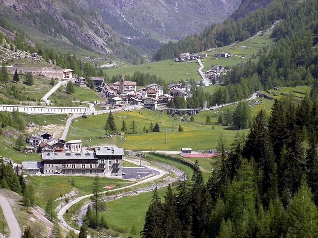
|
The inhabitants
And tell them what? Who are shy and that women sew and embroider draps (traditional clothes and napkins) who sew the draps then sell at the Fair of Saint Orso in Aosta, January 31th, as is the case for over 1000 years? The patience to make these embroideries requires long periods of solitary reflection inside very long winters? That in order to study, as did my partner Germano Bois, current Secretary to Valgrisa Municipality, when together we attended the of Elementary School Teachers at Aosta while I quietly got up at 7.00 am in the morning he had to do two hours earlier? That's when it begins to snow you stay out of the world for almost five months? Now that you are a lucky because television does not make you feel different from others and completely out of this world? Why do you widen the road sweeping the snow? For all these reasons, my dear inhabitant of Valgrisa, you've lost your roots. Forever. Bury your dead in due time, but do not spend more vigils near the fireplace with fire made with wood that, in a hurry, you had to gather in the nearby forest. Before the sun goes down ...Campings
Remember that free camping is forbidden (except for emergency reasons, over 2.500m, from darkness until dawn).
Mountain Conditions
- Meteo: you can find all the needed informations at the official site of the Valle d'Aosta Region:
- Valle d'Aosta Meteo
Books and Maps
BOOKS:
- "Il Parco Nazionale del Gran Paradiso (Valli Soana-Orco-Rhêmes-Valgrisenche)" di Giulio Berutto, I.G.C. Torino 1979.
- "Guida dei Monti d'Italia – Alpi Graie Centrali" di Alessandro Giorgetta - Club Alpino Italiano/Touring Club Italiano, 1985 (in Italian).
 |
 |
MAPS:
- Kompass "Gran Paradiso Valle d'Aosta Sentieri e Rifugi" Carta turistica 1:50.000.
- L'Escursionista "Valgrisenche Val di Rhêmes" Carta dei sentieri (n° 3) 1:25.000.
- Enrico Editore Ivrea-Aosta "Gruppo del Gran Paradiso" 1:50.000.
- I.G.C. Istituto Geografico Centrale "Valsavarenche-Valle di Rhêmes-Valgrisenche" Carta dei sentieri e dei rifugi (carta n° 102) 1:25.000.
Important Information
- REGIONE AUTONOMA VALLE D'AOSTA the official site.
- FONDAZIONE MONTAGNA SICURA Villa Cameron, località Villard de la Palud n° 1 Courmayeur (AO) Tel: 39 0165 897602 - Fax: 39 0165 897647.
- SOCIETA' DELLE GUIDE DI VALGRISENCHE
- A.I.NE.VA. (Associazione Interregionale Neve e Valanghe).
Useful Numbers
- Protezione Civile Valdostana località Aeroporto n° 7/A Saint Christophe (Ao) Tel. 0165-238222.
- Bollettino Meteo (weather info) Tel. 0165-44113.
- Unità Operativa di Soccorso Sanitario Tel. 118.