This mountain is the final part of the watershed along Urtier/Grauson that, starting from the Col des Invergneux also, in ancient times, Hevergnes (2.902m), form a small Subgroup of Penne Blanche. We will have in succession, from East to West, Tete de Vallonet, Eastern Penne Blanche (3.248m), the highest peak of this small mountain range, Saddle of 3.148 meters or Penne Blanche Pass, Western Penne Blanche, Pass and Pointe Coupée, Sella 3.105 meters, Tete de Money, wide saddle 2.971 meters and, finally, Monte Creya (3.015m). From this point the watershed splits sending towards South with a ridge in the direction of Mont Salet, such as to divide the Walloon Liconi from the lower part of that of Grauson, while another or Northwest drops, signaled by a series of large mounds stoneand cairns towards the Alp Créuzet (2.244m) and the Old Grauson Pasture (2.273m; recently restored, at least in part) under the Southeast Face of the Grauson majestic Tower. Lovely day Hiking that has beautiful views of the Gran Paradiso Mountain Chain, which is right in front, and on the Cogne Resort, in the opposite direction, the entire Group Garin/Emilius/Grande Roise or Roizà (from the ancient Celtic word glacier). It can also become a cultural tour that linking the two ways (good connection of marked trails), door to visit the famous mining site of the Cogne Valley (from the L'E'closeur connection via path n° 8D with vein mine of Larsinaz (1.899m), Plan de Mount- Salet, Mine Costa del Pino (2.026m) and from this path n° 9 at Colonna Miners Village). Splendid Tour Excursion/Hike and somewhat instructive for the boys; all still in a somewhat wild.
Questa montagna costituisce la parte conclusiva del lungo spartiacque Urtier/Grauson che, partendo dal Passo d'Invergneux o des Hevergnes (2.902 m), forma il piccolo Sottogruppo dei Penne Blanche. Avremo così in successione, da Est verso Ovest, Tete de Vallonet, Penne Blanche Est (3.248 m), la cima più elevata di questa piccola catena montuosa, Sella 3.148 metri o Colle dei Penne Blanche, Penne Blanche Ovest, Colle e Pointe Coupée, Sella 3105 metri, Tete de Money, larga Sella 2.971 metri ed infine Monte Creya (3.015 m). Da questo punto il divisorio si sdoppia inviando verso Mezzogiorno una cresta in direzione del Mont Salet, tale da dividere il Vallone di Liconi dalla parte inferiore di quello del Grauson, mentre un'altra o Nordovest scende, segnalata da una serie di grandi tumuli in pietra, verso le Alpi del Créuzet (2.244 m) ed il Vecchio Grauson (2.273 m; questi é da poco tempo ristrutturato, almeno in parte), sotto il Versante Sudorientale della maestosa Torre di Grauson. Bella gita Escursionistica che presenta splendide vedute sulla Catena del Gran Paradiso, ergentesi proprio dirimpetto, sul Paese di Cogne e, nel senso opposto, sull'intero Gruppo Garin/Emilius/Grande Roise o Roizà (o ghiacciaio, dall'antica voce celtica). Inoltre può diventare una gita culturale che, collegando le due vie (valida connessione di sentieri segnalati), porta a visitare il famoso sito minerario della Valle di Cogne (dall'E'closeur collegamento tramite il sentiero n° 8D con il Filone di Larsinaz (1.899 m), Plan de Mont-Salet, Miniera Costa del Pino (2.026 m) e da questa con sentiero n° 9 a Colonna). Splendido Giro Turistico/Escursionistico ed alquanto istruttivo per dei ragazzi; il tutto ancora in un ambiente alquanto selvaggio.
First Ascents
First on the summit: Unknown.
In winter: Unknown.
Getting There
BY CAR:
From Torino, Milano, etc: Motorway A5. Exit at Aosta Ovest. Drive to the near Aymavilles. Follow the directions for Valle di Cogne.
From Switzerland: through the Grand Saint Bernard Tunnel or the namesake Pass. Drive to Aosta, then follow the direction for Courmayeur on SS.26. Just after Sarre, turn to the left, in the direction of Valle di Cogne.
From France: through Mont Blanc Tunnel or Petit St. Bernard Pass. It isn't necessary to take Motorway A5: you can drive on SS.26, in the direction of Aosta. Before arriving at the Village of Sarre, turn right following the sign for Valle di Cogne. After Aymavilles, the SR.47 crosses the Villages of Vieyes, Epinel and Cretaz and after about 25 Km arrives at Cogne (1.534m).
BY PLANE:
Aeroporto "Corrado Gex" Saint Christophe (Aosta).
Approach A (From Gimillan to Money Lake)
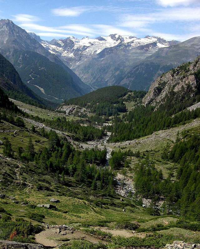
From the city of Aosta (583m), the capital of the region, walk along the SS.26 until the junction that leads to the charming town of Aymavilles (646m) 8 km away, from Aosta. From the central square of the village we take the Regional Road n°47 and after passing the Hamlet of Vieyes (1.142m), the last Fraction of Aymavilles or Epinel (1.452m) and Crétaz (1.499m) will take you to Cogne Resort (1.534m) (28 km. from Aosta). After going through the entire village and reached the Chapel of St. Anthony, where she was a newly built roundabout, take the road that leads to Gimillan Village (1.787m) 3 km. from Cogne. Go right starting from the car park of Gimillan: after few meters, the indications for Lussert Lakes, St. Marcel Pass, etc. are found. The pathway is indicated by the yellow circle and by yellow strips marked on stones along the route. The path begins going immediately uphill, then the slope decreases as we go beyond a little chapel dedicated to the Virgin (1.836m). Soon the path resumes to go up and splits in two, before it begins to penetrate into the Grauson Valley: it's possible to continue following the right one that goes down as far as the Ecloseur Bridge (1.904m), but in such a case we must go up again; it's better to follow the left one that, in practice without losing height, arrives at the bridge under the Alpeggio Pila (2.025m), cross it and, following the stepped pathway, overcome the rocky bastion beside a fine waterfall (at the left). At this point the path turns right markedly, entering, high on the torrent, into a small walloon; by an alternation of steep and slight slopes, it reaches a panoramic cross, on the edge of a pleasant plateau (superb view of the far La Grivola!). The path goes through the meadows, slightly descendind: after the Alpi di Grauson Vecchie (2.273m) (1h'45/2h'00 from Gimillan Hamlet).
Dalla città di Aosta (583 m), capoluogo dell'omonima regione, si percorre la SS.26 fino all'altezza del bivio che conduce alla ridente località di Aymavilles (646 m), 8 km. da Aosta. Dalla piazza centrale del paese s'imbocca la Strada Regionale n°47 e dopo aver oltrepassato le località di Vieyes (1.142 m), ultima frazione di Aymavilles, di Epinel (1.452 m) e Crétaz (1.499 m) si giunge a Cogne (1.534 m) (28 km. da Aosta). Dopo aver attraversato l'intero abitato e raggiunta la cappella di S. Antonio, dov'è stata recentemente costruita una rotonda, prendere la strada comunale che conduce a Gimillan (1.787 m), 3 km. da Cogne. Qui posteggiare l'auto nel grande piazzale ed inoltrarsi tra le case; a destra, dopo pochi metri, si trovano i cartelli con l'indicazione per i Laghi Lussert, il Colle di Saint Marcel ecc... Il percorso è segnalato con il disco giallo e con strisce gialle lungo il percorso. Dopo aver oltrepassato in un tratto di falsopiano una piccola cappella dedicata alla Madonna (1.836 m), il sentiero riprende a salire e, prima di iniziare ad addentrarsi nel vallone di Grauson, si sdoppia; tenersi su quello di sinistra (si può proseguire anche sulla destra verso il ponte di Ecloseur (1.947 m), ma questo obbligherebbe poi ad una noiosa risalita), superare il piccolo ponticello di legno e proseguire fino al ponte posto sotto l'alpeggio Pila, attraversarlo e, seguendo il sentiero a gradoni, superare la bastionata rocciosa a fianco della quale scroscia una bella cascata. Ora il vallone gira decisamente sulla destra, un'alternanza di bruschi strappi e tratti in falsopiano conduce ad una croce, sull'orlo di un ameno pianoro, da cui si gode una vista superba della lontana Grivola, percorrerlo sino alle Alpi di Grauson vecchie (2.273 m)(1h'45/2h'00 dal Villaggio di Gimillan).
Approach B (From Lillaz-Champlong to Colonna Mines)
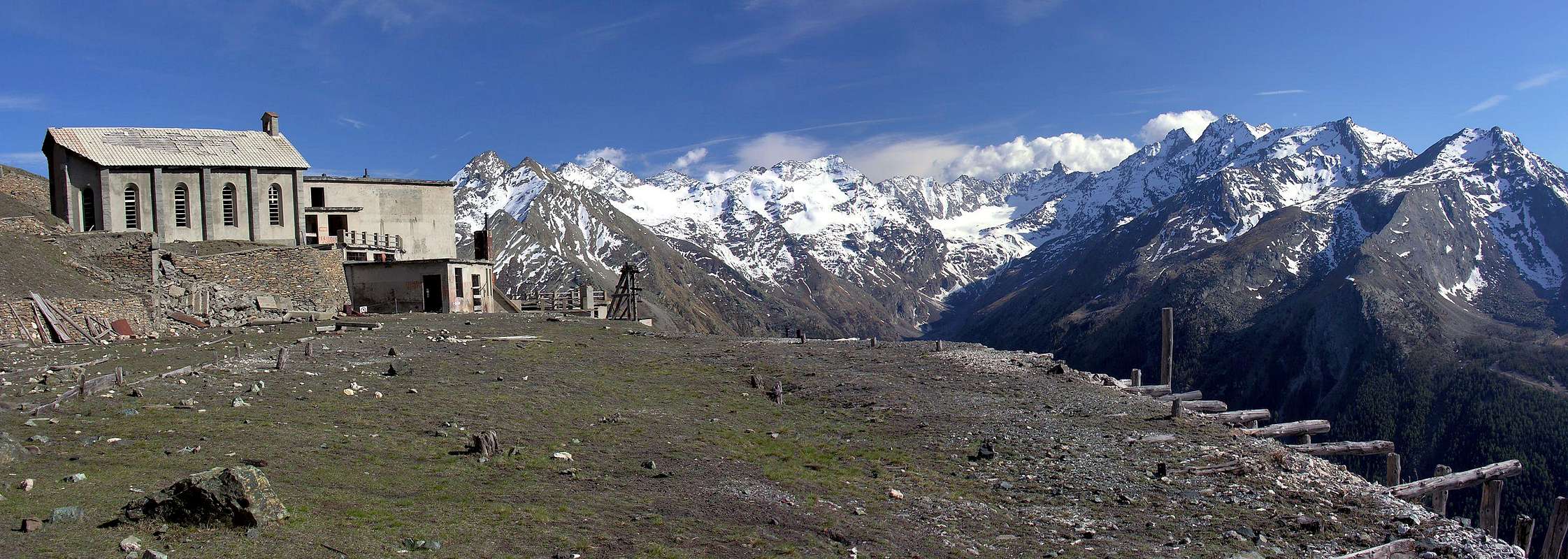
From Cogne reach through the Regional Road Champlong/Saint-Pierre (1.596m), from this point take the path towards Northwest n° 7A and reach Facette Pasture (1.662m). Leaving on the left the trail with a long crossing to the West-northwest is directed to the Village of Montroz always with the trail n° 5. Continuing instead to the North dominating from the Walloon of the Torrent Liconi and reaching the largest concentration which is the remains of the homes of miners Colonna (2.386/90m; extraction of the valuable Cogne magnetite or loadstone; 1h'30/2h'00).
Da Cogne raggiungere tramite la Strada Regionale Champlong/Saint-Pierre (1.596 m); da questo punto prendere in direzione Nordovest il sentiero n° 7A che raggiunge l'Alpe Facette (1.662 m). Lasciando sulla sinistra il sentiero che con una lunga traversata verso Ovest-nordovest si indirizza al Villaggio di Montroz sempre con il sentiero n° 5, continuare invece verso Nord dominando dall'alto il Vallone del Torrente Liconi e raggiungendo il grande agglomerato che costituisce i resti delle abitazioni dei minatori di Colonna (2.386/90 m; estrazione della pregiata magnetite di Cogne; 1h'30/2h'00).
Route A (From Money Lake into Grauson Walloon)
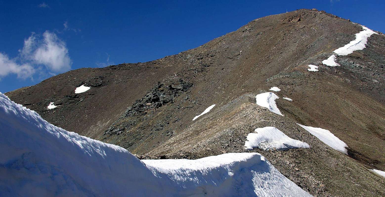
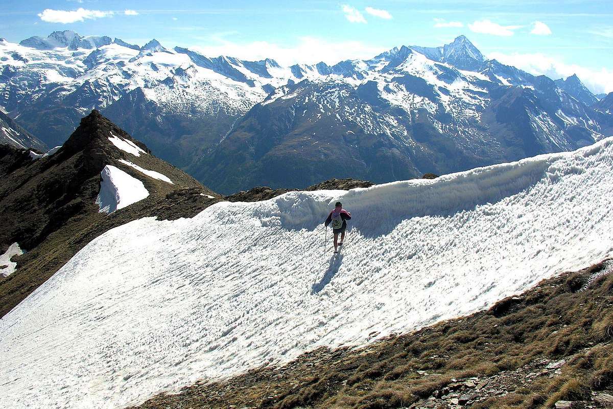
From Grauson Vieux, or rather, from the junction immediately after entering the grassy plateau (2.298m), turn right (Southeast) and via the route n° 8C, passing under some benches of rock, and reach over across the torrent which descends from Lake of Money (2.550m), at his emissary to the South of that. Rounding to the right (West) to come up with the lake heading Southwest via a small path not numbered, and the same, gradually turns into a track between steep grassy slopes. Follow it up to about 2.910/20 meters, where it disappears just below the Crest Northwest near the 2.968 meters altitude. Along this (endless meadows of edelweiss), you will soon reach the Top (E; 1h'30/1h'45 from Grauson Vieux).
Northern Face
Da Grauson Vieux, o meglio, dal bivio subito dopo l'ingresso nel plateau erboso (2.298 m) deviare a destra (Sudest) e tramite il sentiero n° 8C, passando al di sotto di alcuni banchi di roccia, raggiungere e oltre passare il torrente che scende dal Lago di Money (2.550 m), presso il suo emissario a Sud del medesimo. Doppiando sulla destra (Ovest) il lago salire con direzione Sudovest tramite un piccolo sentiero non numerato; lo stesso, progressivamente, si tramuta in una traccia tra ripidi pendii prativi. Seguirlo fino a 2.910/20 m~, dove scompare appena al di sotto della Cresta Nordovest nei pressi della quota 2.968 metri. Percorrendo questa (prati sterminati di stelle alpine), in breve si raggiunge la Cima (E; 1h'30/1h'45 dal Grauson Vieux).
Route B (From Champlong or "Way of the Mines")
From Colonna continue with trail n° 5 to the Northeast climbing to the overlying Miniere di Liconi (2.495m), just below the Mont Salet (2.764m) from these down to the bottom of the deep valley of the same name and Liconi reaching the stream crossing for twice. Returning to the left (west) and continue towards the north, again on a comfortable path and passed three bends, reaching the south-southwest ridge that connects to the Mont Salet. With this easy to reach the summit (1h'00 from Colonna Mines Village; 2h'45/3h'00 in total from Champlong Fraction).
Da Colonna continuare con il sentiero n° 5 verso Nordest salendo alle soprastanti Miniere di Liconi (2.495 m), subito al di sotto del Mont Salet (2.764 m); da queste scendere sul fondo del Vallone di Liconi raggiungendo il torrente omonimo ed attraversandolo per due volte. Ritornati a sinistra (Ovest) continuare verso Settentrione e, sempre su comodo sentiero e superati tre tornanti, raggiungere la Cresta Sud-sudovest collegantesi al Mont Salet. Tramite questa facilmente raggiungere la Sommità (1h'00 dal Villaggio Minerario di Colonna; 2h'45/3h'00 in totale dalla Frazione Champlong).
Southern Slope
Difficulties & Descent
E/F (for both the routes).
E/F (per entrambe le vie).
Options Descent
Identical ascent route, or a combination, in preference, the two paths. In this case, keep in mind, after the descent on Grauson Vallon at Ecloseur small Pasture, the path n°8D with Vein Mine of Larsinaz (1.899m) Plan de Mont-Salet, Mine Costa of Pino (2.026m) and this path with connection at Colonna n° 9, otherwise vice versa with direct Southern descent to the Mines Liconi, Colonna, Champlong-Lillaz Hamlets in Cogne Valley.
Identica via di salita, oppure combinando, a preferenza, le due vie. In siffatto caso tenere presente, dopo la discesa nel Vallone del Grauson verso gli Alpeggi dell'Ecloseur, il sentiero n°8D con il Filone di Larsinaz (1.899 m), Plan de Mont-Salet, Miniera Costa del Pino (2.026 m) e da questa con sentiero di collegamento n° 9 verso Colonna; altrimenti viceversa con discesa diretta verso Sud alle Miniere di Liconi, Colonna, Champlong presso Lillaz in Val di Cogne.
Equipment
Hiking gear.
Da Escursionismo.
Campings
Remember that free camping is forbidden (except for emergency reasons, over 2.500m, from darkness until dawn).
Red Tape
The Southern side of the valley belongs to Gran Paradiso National park, the Western one is out of the boundaries of the Park ... but nature must be respected.
Mountain Condition
You can get meteo information at the official site of the Regione Valle d'Aosta:
"Guida delle Alpi Occidentali" di Giovanni Bobba e Luigi Vaccarone C.A.I. Sezione di Torino Volume II (parte II), 25 Maggio 1896.
"Guida dei Monti d'Italia Emilius Rosa dei Banchi Parco del Mont Avic" di Giulio Berutto e Lino Fornelli - Club Alpino Italiano/Touring Club Italiano, Marzo 2005.
"Diari Alpinistici" di Osvaldo Cardellina e Indice Generale accompagnato da Schedario Relazioni Ascensioni 1964-2019 (unpublished).
MAPS:
Kompass "Gran Paradiso Valle d'Aosta Sentieri e Rifugi" Carta Turistica 1:50.000.
Enrico Editore Ivrea-Aosta "Gruppo del Gran Paradiso" 1:50.000.
I.G.C. Istituto Geografico Centrale Torino "Gran Paradiso-La Grivola-Cogne" 1:25.000.
L'Escursionista "Tour de la Vallée de Cogne Grand Paradis" Carta dei sentieri 1:25.000.
I.G.C. Istituto Geografico Centrale Torino "Il Parco Nazionale del Gran Paradiso" (3) 1:50.000.
L'Escursionista "Valle di Cogne Carta dei Sentieri" (n° 10) 1:25.000.
Parents refers to a larger category under which an object falls. For example, theAconcagua mountain page has the 'Aconcagua Group' and the 'Seven Summits' asparents and is a parent itself to many routes, photos, and Trip Reports.

 5513 Hits
 86.37% Score
 22 Votes