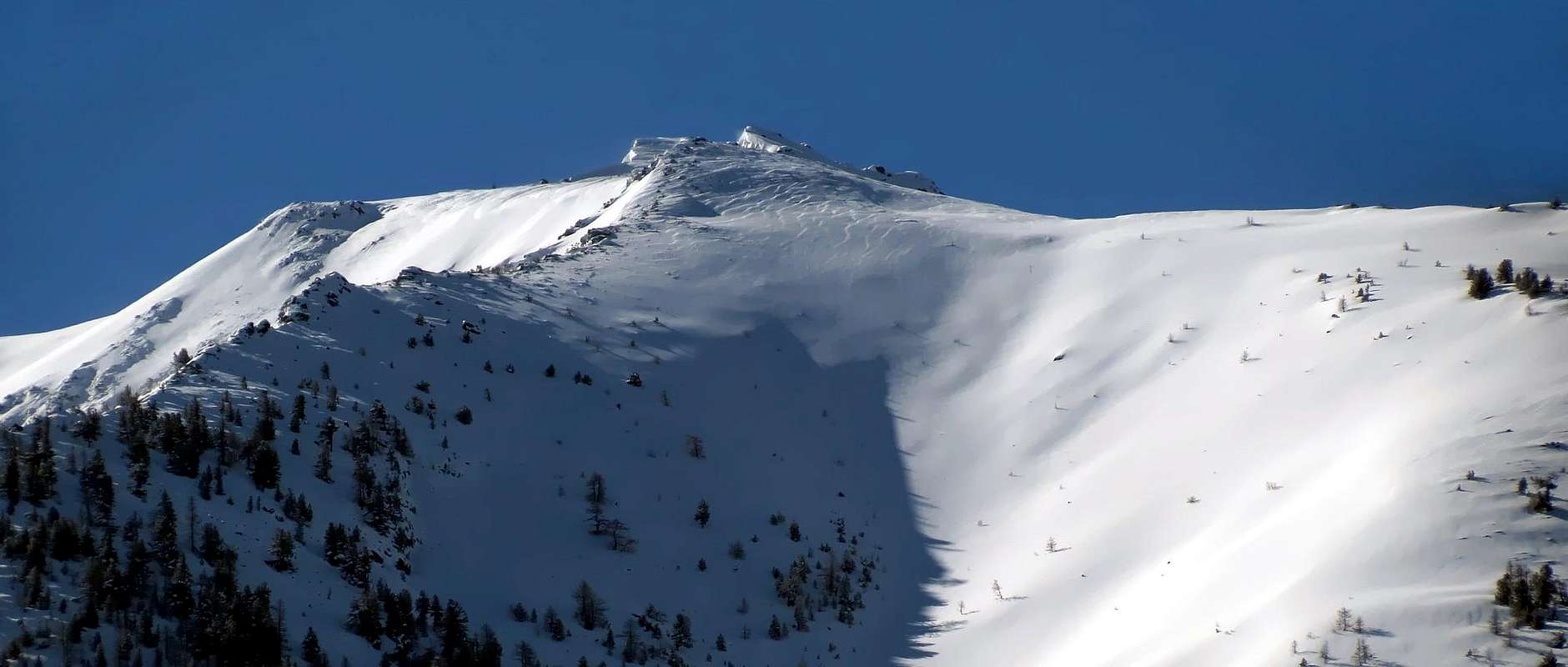
Big bastion, stumpy and from the imposing mass; last of the Great Buttress of the Monte Emilius to N-NE. It overhangs the inhabited areas of Gran Brissogne and Gran Pollein with crags and horrid rocky gullies. Not very frequented, because of the marches of approach. Good panorama on the City of Aosta and on the Group of the Monte Emilius.
Grosso bastione, tozzo e dall'imponente massa; ultima cima del Grande Contrafforte dell'Emilius a N-NE. Sovrasta gli abitati di Gran Brissogne e Gran Pollein con balze e orridi canaloni rocciosi. Non molto frequentato, per via delle marce di avvicinamento. Ottimo panorama sulla Città di Aosta e sul Gruppo dell'Emilius.
First Ascents
First on the summit: Unknown.
In winter: Unknown.
Getting There
BY CAR:
From Torino, Milano, etc: Motorway A5. Exit at Aosta Est.
From Switzerland: through the Grand Saint Bernard Tunnel or the namesake Pass.
From France: through Mont Blanc Tunnel or Petit Saint Bernard Pass. It isn't necessary to take Motorway A5: you can drive on SS.26, in the direction of Aosta.
BY PLANE:
Aeroporto "Corrado Gex"; Saint Christophe (Aosta).
Itinerary
From Aosta to take the Regional Road for Pila (famous ski resort), and to go up again to the Country of Charvensod (Chef Lieu 745m). To continue along the road and few over the second "tornante" to park the car.
Da Aosta prendere la Strada Regionale per Pila (nota stazione sciistica) e risalire al Paese di Charvensod (Chef Lieu 745 m). Proseguire lungo la strada e poco oltre il secondo tornante (cartello) parcheggiare l'auto.
Route
From the small parking area walk up the dirt road to Alpe di Reverier Dessous (1.042m) and passes under the Comboè Torrent on the small bridge Rongachet. Continue for the same name and the next Gorrettaz Alpe (1.089m), away from the junction to the left for Terre Blanche and Dessous Chinoz. Overcoming other pastures: La Barma (1.255m), Martsauchy (1.400m), Plan Croix (1.745m) and Arpisson (2.010m). Continue on the great plateau, keeping to the east of the torrent Arpisson reached close the Springs of Monte Emilius. Turn north-east and climb up the steep slope over two gullies. Small tracks with grass "Ollina", dates back to 2.620m~ altitude just north-west of the summit (4h'30/5h'00).
Dal piccolo parcheggio risalire la strada poderale per l'Alpe di Reverier Dessous (1.042 m) e superare il Torrente Comboè sul piccolo ponte di Rongachet. Proseguire per l'omonima Alpe e la successiva di Gorrettaz (1.089 m), abbandonando a sinistra il bivio per Terre Blanche Dessous e Chinoz. Superare gli altri alpeggi: La Barma (1.255 m), Martsauchy (1.400 m), Plan Croix (1.745 m) e Arpisson (2.010 m). Continuare sul grande pianoro tenendosi a Est del Torrente Arpisson sino a raggiungere quasi le Sorgenti del Monte Emilius. Voltare a Nord-est e risalire il ripido pendio superando due canaloni. Per piccole tracce con erba "Ollina", risalire alla quota 2.620 m~ appena a Nord-ovest della cima (4h'30/5h'00).
Difficulty
The route can be classified as EE.
L'itinerario è classificato EE.
Equipment
Normal hiking equipment.
Da escursionismo.
Campings
Remember that free camping is forbidden (except for emergency reasons, over 2.500m, from darkness until dawn).
Mountain Condition
Meteo: you can find all the needed informations at the official site of the Valle d'Aosta Region:
"Guida del Monte Emilius", di Osvaldo Cardellina Editore in collaborazione con il Club Alpino Italiano Sezione di Aosta, Dicembre 1978.
"Guida dei Monti d'Italia – Emilius Rosa dei Banchi Parco del Mont Avic" di Giulio Berutto e Lino Fornelli - Club Alpino Italiano/Touring Club Italiano, Marzo 2005.
"Diari Alpinistici" di Osvaldo Cardellina e Indice Generale accompagnato da Schedario Relazioni Ascensioni 1964-2019 (inediti).
MAPS:
Kompass "Gran Paradiso Valle d'Aosta Sentieri e Rifugi" Carta turistica 1:50.000.
L'Escursionista "Conca di Aosta-Pila-Monte Emilius" Carta dei sentieri (n° 4) 1:25.000.
Hapax "Les Sentiers Comunità Montana Monte Emilius", Luglio 2000 1:25.000.
Enrico Editore Ivrea-Aosta "Gruppo del Gran Paradiso" 1:50.000.
I.G.C. Istituto Geografico Centrale, Torino "Carta delle Passeggiate ed Escursioni in V.D.A. Conca di Pila-Gressan, 1:20.000.
Parents refers to a larger category under which an object falls. For example, theAconcagua mountain page has the 'Aconcagua Group' and the 'Seven Summits' asparents and is a parent itself to many routes, photos, and Trip Reports.

 6456 Hits
 84.27% Score
 18 Votes