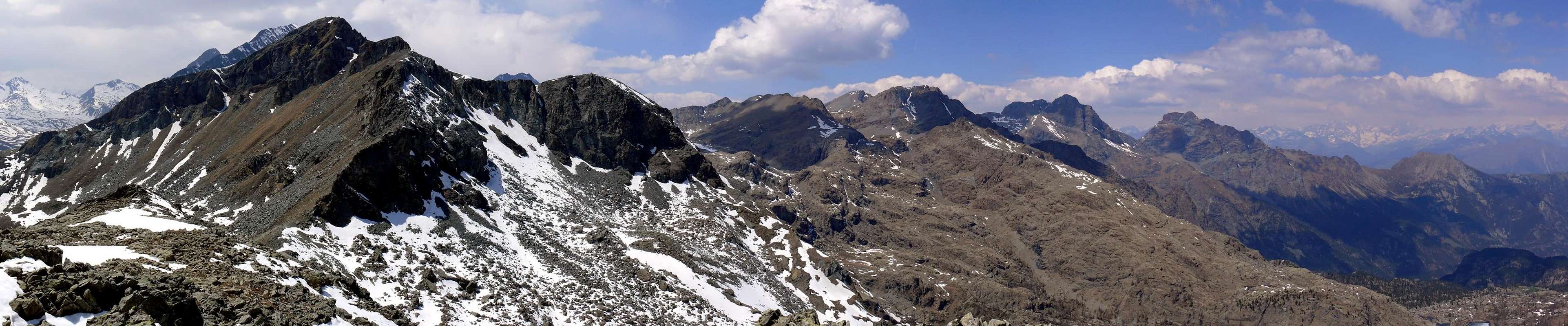
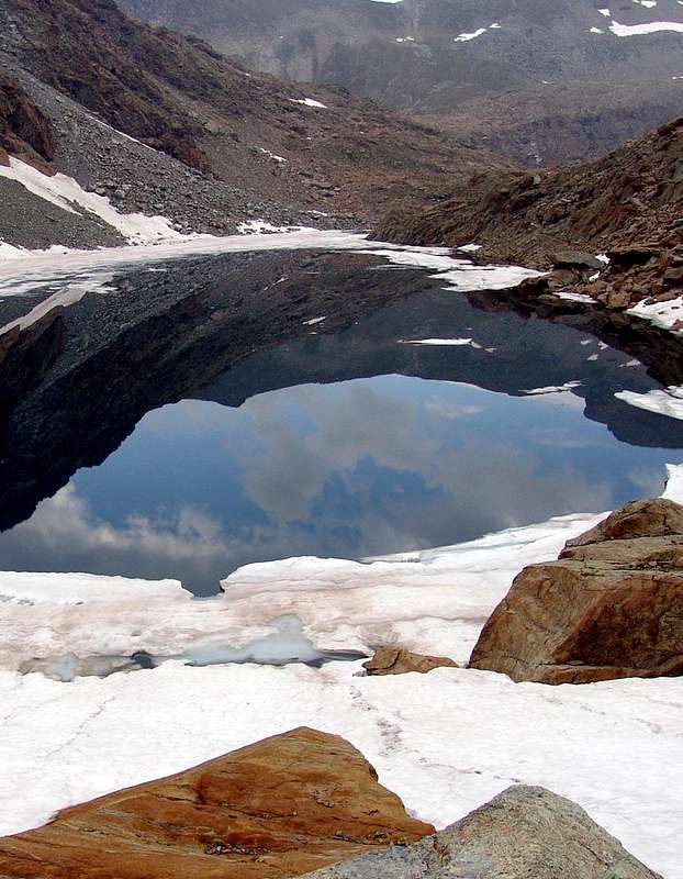
Summit little known and poorly attended, turns out to be higher than that little Subgroup between the Group of Mount Glacier (3.186m) in the South and the Mount Avic (3.006m) to the North, on the long ridge watershed that descends from the first to the North vertically to the central axis of the Stream Dora Baltea between the Towns of Fénis, Chatillon, Saint Vincent and the Montjovet. INTO the BOUNDARIES of NATURE PARK * This ridge defines the boundaries of the West and Northeast Natural Park of Mount Avic to Mount Barbeston (2.482m). The others are bordered to the South by the ridge from the Mount Glacier (the highest peak in this area to the East of Tersiva Point (3.515m), which in turn second highest after Mount Emilius (3.559m) in that vast area including the City Aosta and the country of Pont Martin to Northern and I is not Champorcher Valley, as well as the side valleys to the Valleys Chiusella and Soana overlying the City of Ivrea, zone called the Graian Alps of the Southeast) Hills reaches of the White Lake and of the Cross. To the East the boundary is delimited by the same ridge from Cima Piana is directed more toward the Northeast Bec Gavin (2.001m) and from this the boundary of the Park abandons the ridges watershed and descends to the North up above the Village of Gettaz des Allemands, and then close the circle in the direction of Volla or Veulla Hamlet and back to Barbeston. The Guide de C.A.I./T.C.I. "Emilius Rosa dei Banchi Park M. Avic," by Giulio Berutto and Lino Fornelli, March 2005 circumscribes the mountain in a subgroup of Frozen Loch Envers said, including as mentioned above between Mount Glacier and Mount Avic, but that has as its point of reference, at least regarding the Eastern Slope, precisely the Lake Gelato (= Frozen; 2.587m) in the upper walloon belonging to the Municipality of Champdepraz. And, more specifically, this tiny subset is bounded by Mezove also Medzove Pass (2.614m), on the slopes of the ridge North-northeast of Glacier and Champdepraz Valley between the East and the Walloon of Savoney, side Valley of Val Fénis Clavalité, and Raye Chevrère (2.703m), large hill in the shape of a large saddle between it and the Walloon of the Bella Lana, secondary, and still belonging to this last valley. The Mount Iverta does not offer great perspectives and possibilities for climbing, although the East-northeast wall has a large unexplored, this option must be sought in the mountains next to him, or the Inverse or Envers of Frozen Lake, The Flat Head, the Bec l'Espic and Orso (= Bear) Mountain. The other sides are all debris, for which reason the best route is located on its ridges watershed North-northwest and South-southeast, another crest of lesser importance and easy climb is facing Southeast towards the Envers Pass and the Plateau or Iableland of Iverta. If little known to the mountaineering point of view, the Iverta was famous for centuries for its iron mines of loadstones (2.616m) adjacent to Lake Gelato, of which you can still see the entrances and the remains of the buildings that housed the miners, even in winter; we dare to think like them the rounded mass of the mountain, who "stole" them the sun, could be annoying! Good vantage point, but limited to the mountains above.
Cima poco conosciuta e scarsamente frequentata, risulta esser la più elevata di quel piccolo Sottogruppo rappreso tra il Gruppo del Mont Glacier (3.186 m) a Meridione e quello del Monte Avic (3.006 m) a Settentrione, sulla lunga cresta spartiacque che dal primo discende a Nord verticalmente all'asse centrale del Fiume Dora Baltea tra i Comuni di Fénis, Chatillon, Saint Vincent e Montjovet. DENTRO ai CONFINI del PARCO NATURALE Questa cresta determina i confini Ovest e Nordest del Parco Naturale del Monte Avic sino al Mont Barbeston (2.482 m). Gli altri vengono delimitati a Sud dalla cresta che dal Mont Glacier (cima più alta di questo settore ad Oriente della Punta Tersiva (3.515 m), a sua volta seconda in altezza dopo il Monte Emilius (3.559 m) in quella vasta area compresa dalla Città di Aosta e il Paese di Pont Saint Martin a Settentrione e la Valle di Champorcher, nonché delle valli laterali fino alle Valli Chiusella e Soana soprastanti la Città di Ivrea, zona detta delle Alpi Graie del Sudest) raggiunge i Colli del Lago Bianco e della Croce. Ad Est il confine dello stesso viene delimitato dalla cresta che dalla Cima Piana s'indirizza più a Nordest verso il Bec Gavin (2.001 m); da questi il confine del Parco abbandona le creste spartiacque e discende verso Nord insino sopra l'abitato di Gettaz des Allemands, per poi chiudere il cerchio in direzione di Volla o Veulla e risalire al Barbeston. La Guida de C.A.I./T.C.I. "Emilius Rosa dei Banchi Parco del M. Avic", ad opera di Giulio Berutto e Lino Fornelli, 2005, inquadra questa montagna in un Sottogruppo detto dell'Envers del Lago Gelato, compreso come già detto tra il Mont Glacier ed il Monte Avic, ma avente come punto di riferimento, almeno per quanto concerne il Versante Orientale, appunto il Lago Gelato (2.587 m) nell'alto vallone proprio del Comune di Champdepraz. E, più precisamente, questo minuscolo sottogruppo viene delimitato dal Col Mezove oppure Medzove (2.614 m), alle pendici della Cresta Nord-nordest del Glacier e tra il Vallone di Champdepraz ad Est ed il Vallone di Savoney, laterale della Val di Fénis-Clavalité, e la Raye Chévrère (2.703 m), ampio colle a forma di larga sella, tra il medesimo ed il Vallone della Bella Lana, secondario e pur sempre appartenente a questa ultima vallata. Il Monte Iverta non offre grandi prospettive e possibilità per l'arrampicata, anche se ad Est-nordest presenta una grande parete ancora inesplorata; questo optional va ricercato nelle montagne a lui prossime, ovvero l'Invers od Envers del Lago Gelato, la Testa Piana, il Bec l'Espic ed il Monte Orso. Gli altri versanti sono tutti detrici, per la qual cosa il percorso migliore trovasi sulle sue creste spartiacque Nord-nordovest e Sud-sudest; un'altra cresta di minore importanza e di facile salita si trova rivolta a Sudest in direzione del Colle dell'Envers e del Plateau dell'Iverta. Se poco conosciuto dal punto di vista alpinistico, l'Iverta era famoso da molti secoli per le sue miniere di ferro (2.616 m) adiacenti al Lago Gelato, delle quali ancor oggi si possono intgravvedere gli imbocchi ed i resti delle costruzioni alloggianti i minatori, anche in inverno; osiamo pensar come a questi ultimi la massa tondeggiante della montagna, che "rubava" a loro il sole, potesse dare fastidio! Buon punto panoramico, ma circoscritto alle montagne sopra citate.
First Ascents
First on the summit: Unknown.
In winter: Unknown.
NW Crest (from Raye Chevrère Pass): Unknown.
N Face (from Raye Chevrère Pass): Osvaldo Cardellina, lone (Aug 04th, 2001), in ascent after Mont Avic.
E-SE Crest (from l'Invers of Frozen Lake Pass): Unknown.
S Ridge (from Medzove Point): Unknown.
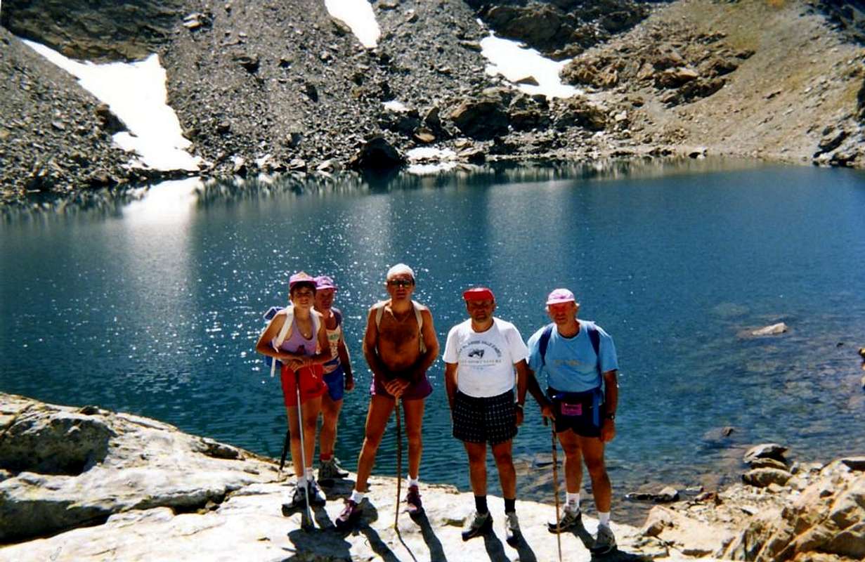
Great Traverse (from Voella to Voella): Lake Gelato-Rayes Chevrères Hill-Quota 2.827m or Raye Chevrères Point-Quota about 2.940m-Mount Avic-return to Rayes Chevrères Hill-Iverta Lake and Mount-Medzove Point-Saddle about 2.800m-Mount Belplà-Gran Lago and other with descent to Serva Loch and Voella); Osvaldo Cardellina, Christian Cardellina and Marco Cossard; (Sep 04th, 1983), in day.
Getting There
BY CAR:
From Torino, Milano, etc: Motorway A5. Exit Verrès for then to continue on SS.26 toward Champdepraz.
From Switzerland: through the Grand Saint Bernard Tunnel or the namesake pass. Drive to Aosta, Verrès and Champdepraz.
From France: through Mont Blanc Tunnel or Petit Saint Bernard Pass. It isn't necessary to take Motorway A5: you can drive on SS.26, in the direction of Aosta and Verrès.
BY PLANE:
Aeroporto "Corrado Gex" Saint Christophe (Aosta).
Specific Itinerary Road From the Municipalities of Verrès (391m) in Southeast, or Montjovet (489m) to catch up with the Northwest Regional Road, South of Dora Baltea and Motorway A5, to Champdepraz (523m), located at the entrance of the with the same name valley. From this go along way toward Southeast with a first series of seven switchbacks to the junction, near the Bridge of Gorf, for Gettaz des Allemands (995m, old village that bears witness to the passage of Walser) a dozen others, even closer, door in the upper part of the walloon, dominating from steep and wild precipices overhanging the Torrent de Chalamy, which originates at the base of the Northern Slope of the Invers. Left to right (West) to the branch Crestaz (1.293m) with its ancient ironmines, the same goes with a long diagonal to the South reaching Villages Barbustel or Barbuste (1.240m) and the adjacent Covarey, just before you reach Volla or Voella (1.307m; Museum of the Natural Park of Mont Avic, small restaurant with a few rooms amongst the houses not long ago renovated keeping the style of the Aosta Valley), where it ends with ample parking.
Approaches
Approach A (From Champdepraz Valley, Voella Hamlet, Chalamy Valley to Ironmines nearby Frozen Loch) From Champdepraz, reachable by Verres, the Hamlet of La Ville-Veulla (1.248m; parking) for the farm road to the "Magazine" until the junction for Praz Orsie or Pra Oursi Pasture, just across the creek Treby at an altitude of 1.340m~; proceeds in the direction of West passing a first stream and small, near a second at a crossroads, left to right (North) Pian Tsatsè the path for reaching the pasture at an altitude of 1.791m(1h'00/1h'15). From Praz Orsie Alpage definitely changing direction towards the South to reach the path that leads through n° 7B (the same goes to the North going up to Mount Barbeston) first the path that leads from the "Warehouse" and then into the gorge central halls Veulla or Walloon of Chalamy. From this junction continue through the path n° 6 which dates from the same passing parallel and just above the Chaleby Torrent. The same salt wedged deeper into the small valley and, through long straight section under a rock band at the base of the South East Slope of Mount Avic, shall be directed towards a narrow passage formed by the three rock outcrops that descend dall'Invers of Lake Ice (2.915m), the second highest mountain in altitude for the small subgroup. The rich vegetation of mountain pines and firs, including illustrative signs appear, gradually thins out, while the front stands the gloomy ominous spire of the Bec l'Espic, overlooking the valley with his daring North and West Walls , always continuing along the left side basin (West), the path turns away from the Torrent Chalamy to go round to the right (West always) a rocky spur and "broken" and would be the first or most Northern of those who go down almost parallel by mass dell'Invers. The trail gradually turns into a dirt road, built for the descent of the mineral through large sledges, reaching a more open below the glacis which are located above the "magnetite" or loadstones mines, active until 1863 but surely already known and used previously. Turning more to Southeast (left, up) the same, supported by dry stone walls and embankments, through discharges of the same; turning then reaches a plateau in the Southwest near the emissary of Lake Gelato. As they came near the caves of Mines (closed), leaving just the top right corner the remains of barracks and a refuge of Forestry (private and closed) reaches the narrow ledge Northern of the lake, in a beautiful esplanade able to "salle à manger" (3h'30/4h'00).
Avvicinamento A (Dalla Valle di Champdepraz, Villaggetto di Voella, Vallone di Chalamy al Lago Gelato presso le Miniere di ferro) Da Champdepraz, raggiungibile da Verrès, alla Frazione di La Ville-Veulla (1.248 m; parcheggio), per la strada poderale verso il "Magazzino" sino al bivio per Praz Orsie o Pra Oursi, appena oltre il Torrente di Tréby a quota 1.340 m~; salire con direzione Ovest superando un primo torrentello e, nei pressi d'un secondo ad un bivio, lasciare a destra (Nord) il sentiero per Pian Tsatsè raggiungendo l'alpeggio a quota 1.791 m(1h'00/1h'15). Da Praz Orsie cambiando decisamente direzione verso Sud raggiungere tramite il sentiero di collegamento n° 7B (lo stesso prosegue verso Settentrione salendo al Monte Barbeston) dapprima il sentiero che sale dal "Magazzino" e successivamente inoltrarsi nel vallone centrale che sale da Veulla o Vallone di Chalamy. Da questo bivio proseguire per mezzo del sentiero n° 6 che risale il medesimo transitando parallelamente ed appena più in alto dell'omonimo torrente. Lo stesso prosegue incuneandosi sempre di più nel valloncello e, passando per lungo tratto rettilineo sotto una fascia rocciosa che cinge alla base il Versante Sudest del Monte Avic, si indirizza verso una strettoia-giogaia formata da questo e da tre costole rocciose discendenti dall'Invers del Lago Gelato (2.915 m), seconda vetta in altitudine per il piccolo sottogruppo. La vegetazione ricca di pini uncinati ed abeti, tra i quali appaion dei cartelli illustrativi, si dirada progressivamente, mentre frontalmente s'erge minacciosa la tetra guglia del Bec l'Espic, che domina dall'alto il vallone con le sue ardite Pareti Nord ed Ovest; sempre proseguendo lungo il versante sinistro idrografico (Ovest), il sentiero si allontana dal Torrente Chalamy per andare a doppiare sulla destra (sempre Ovest) una costola rocciosa e "spezzata" tale da costituire la prima o più Settentrionale di quelle che scendono quasi parallele dalla massa dell'Invers. Il sentiero progressivamente si tramuta in una carraia, costruita per la discesa del minerale tramite grosse slitte, raggiungendo una parte più aperta sottostante lo spalto sopra il quale sono situate le miniere di magnetite, attive fino dal 1863 ma sicuramente già conosciute e sfruttate precedentemente. Volgendo più a Sudest (sinistra salendo) la medesima, sostenuta da mura a secco e massicciate, attraversa gli scarichi delle medesime; volgendo poi a Sudovest raggiunge un altipiano nei pressi dell'emissario del Lago Gelato. Passando presso le caverne delle miniere (chiuse) e lasciando appena in alto a destra i resti dei baraccamenti ed un Rifugio della Forestale (privato e chiuso) raggiunge la stretta sponda Settentrionale del lago, presso una bella spianata atta a" salle à manger" (3h'30/4h'00).
Approach B (From the Royal dirt Road by Dondena, Lake Bianco Pass to Barbustel Shelter) From the Village of La Cort, to continue verse West-northwest through Royal Road to Dondena Village reaching not very after a small parking 1.830/40m about; noumerous signs to entry in the Park); to begin awry immediately with the path n°10 that part (North) and it goes up again with steeply zigzagging bringing itself, with direction Northeast, at first toward a small secondary torrent and subsequently placing side by side that more important descendant from the impending Lake Muffé. To go up again along the bank right hydrographic of the same one with the path, almost mule-track, that unties him with a series of hairpin bends flanking the wood, alternate to rectilinear lines in diagonal. Go out, leaving on the right (East) the deviation for the La Grand Cort Pasture (1.944m, that from he is quietly seen here, abandoned among green pastures) so in the superior tableland in her narrowing among the appendixes of the Mount Ros (2.289m) to West and you it terminal of the Southwestern Crest that it climbs to the Point Perche (2.396m; also with the toponym of Perché, or Perforated), or Southern shoulder of the Cima Piana (Plain Top also called Mont de Panaz 2.512m). Continue on the walloon floor through less steep slope with run mostly "open" and, abandoning on the left (West) the deviations for the Loch Vernouille (2.145m) with the paths n° 9C/10B and, momentarily, also the n° 10, climb with the n° 10C reaching the ruin of the old Muffé Pasture (2.076m), close to the homonym Lake suffered to East I approach (2.119m; 0h'30). From this to ascend up with direction Northwest in a area even more disclosed among morainic soil (numerous sources that gush out a little everywhere) again meeting the path n° 10, that it originates from the Loch Vernouille, few more than hundred meters more aloft. To abandon therefore the aforesaid variation continues with, that goes in opposite (Northeast) toward the nearby Lake Bianco Hill (2.308m), and to proceed with this last I pour the neighbour Croix Pass (2.287m), reaching it with a final line of a more steep. A short descent leads quickly to the Barbustel Refuge, at Lake Bianco in the High Champdepraz Walloon or Lakes Valley (E; 1h'15/1h'45).
Avvicinamento B (Dalla Strada Reale per Dondena, Colle del Lago Bianco verso il Rifugio Barbustel) Dal Villaggio di La Cort, continuare verso Ovest-nordovest tramite la Strada Reale Dondena raggiungendo non molto dopo un piccolo parcheggio (1.840/50 m~; nunerose segnalazioni per l'ingresso nel Parco); incominciare col sentiero n°10 che si rivolge subito a monte (Nord) e risale ripidamente zig-zagando portandosi, con direzione Nordest, dapprima verso un torrentello secondario e successivamente affiancando il più importante, discendente dal soprastante Lac Muffé. Risalire lungo la sponda idrografica destra del medesimo con il sentiero, quasi mulattiera, che si snoda con una serie di tornanti affiancando il bosco, alternati a tratti rettilinei in diagonale. Uscire, lasciando sulla destra (Est) la deviazione per l'Alpe La Grand Cort (1.944 m, adagiata tra verdi pascoli) così nell'altipiano superiore nella strettoia tra le appendici del Mont Ros (2.289 m) ad Occidente e la propaggini terminali della Cresta Sudovest risalente alla Cima Perche (2.396 m; o Perché, cioé Forata), o spalla Meridionale della Cima Piana o Mont de Panaz (2.512 m). Continuare sul fondo del vallone con percorso alquanto meno ripido e maggiormente "aperto" e, abbandonando sulla sinistra (Ovest) le deviazioni per il Lac Vernouille (2.145 m) con i sentieri n° 9C/10B nonché, momentaneamente, anche il n° 10, risalire tramite il n° 10C raggiungendo i ruderi dell'Alpe Muffé (2.076 m), vicino all'omonimo Lago, subito ad Est appresso (2.119 m; 0h'30). Da questo proseguire con direzione Nordovest in una zona ancora più dischiusa tra dossi prativi e terreno morenico (piccole sorgenti che sgorgano un poco dovunque) incontrando nuovamente il sentiero n° 10, proveniente dal Lac Vernouille, poco più di un centinaio di metri più in alto. Abbandonare quindi la variante seguita, che continua in opposta direzione (Nordest) verso il Col de la Croix (2.387 m), e continuare con quest'ultimo verso il Colle del Lago Bianco (2.308 m), raggiungendolo con un tratto finale di poco più ripido. Una corta discesa conduce in breve tempo al Rifugio Barbustel, presso il Lago Bianco nell'Alto Vallone di Champdepraz conosciuto anche come Vallone dei Laghi (E; 1h'15/1h'45).
Routes A, B & C
Route A (From Champdepraz-Voella, Frozen Lake, Rayes Chevrères Pass, Iverta Loch and Northwest Crest/West Slope) From Frozen Lake (2.597m) "return" to the Northwest, and passing around the huts of the miners, with a trace of path n°6 reach the end of the Southwest the long rocky rib band at the base of the South East Slope of Mount Avic (See Approach) and through an up and down through large blocks reach the Chevrère Raye or Pass (2.703m; 0h'30), located between Mount Iverta and the homonymous Point (2.827m). From the hill to reach the beautiful Lake Chevrère also called of the Iverta (2.751m), nestled in the Northern foothills of Mount between its ridges West and North-northwest. Through the latter for debris or large blocks easy access to the Peak, keep to the right under the ridge (West), or following it in full with a little challenging but amusing, and just passing shots with an eye on the most profitable big jump of the wall overlooking Lake Gelato. This way, in our opinion, is more beautiful than the next for the Northeast Slope and then along the small ridge Southeast, as described in the Guide of the C.A.I/T.C.I., page 221 (0h'30; total 5h'00/6h'00 from Veulla Hamlet).
Via A (Da Champdepraz-Voella, Lago Gelato, Colle di Rayes Chevrères, Lago dell'Iverta e Cresta Nordovest/Versante Ovest) dal Lago Gelato (2.597 m) "rientrare" verso Nordovest e, passando nei paraggi delle baracche dei minatori, con una traccia di sentiero n°6 raggiungere l'estremità Sudovest della lunga costola rocciosa che fascia alla base il Versante Sudest del Monte Avic (Vedi Avvicinamento) e tramite un saliscendi tra grandi blocchi raggiungere Il Colle delle Raye Chevrère (2.703 m; 0h'30), posto tra il Monte Iverta e l'omonima Punta (2.827 m). Dal colle raggiungere il bel Lago Chevrère detto anche dell'Iverta (2.751 m), incastonato alle pendici Settentrionali del Monte tra le sue Creste Ovest e Nord-nordovest. Tramite quest'ultima per detriti o grandi blocchi raggiungere facilmente la Vetta, tenendosi a destra sotto il filo di cresta (Ovest), oppure seguendola integralmente con qualche piccolo passaggio divertente ed appena impegnativo ma con colpi d'occhio più remunerativi sul grande salto della parete dominante il Lago Gelato. Questa via, a nostro avviso, è più bella della successiva per il Versante Nordest e poi lungo la piccola Cresta Sudest, descritta come via Normale nella Guida C.A.I./T.C.I., pagina 221 (0h'30; in totale 5h'00/6h'00 da Veulla).
Route B (From Champdepraz-Voella, Frozen Lake, Hours Lochs and South-southeast Slope) Through the Iverta Plateau and the Southeast Ridge or of the Frozen Loch: Gelato reached Lake, directed in the sense diametrically opposite (South-east), and outlining its Western side through the continuation of the path n° 6, back in a narrow valley between the Ridge of Invers of Lago Gelato Northwest and East Wall-northeast of Iverta. The same salt leaning towards the first mentioned first and then started taking away against Southern offshoots of the second. Rise to debris flows alternating with snowfields, zigzagging between large boulders polished by ancient glaciers. With a final stretch steeper and turned slightly to reach the Southeast Plateau of Iverta, small tableland between Mount Iverta the small tip Mezove or Medzove (2.848m), Mount Belplà (2.829m), Mount Orso (2.717m) and the Inverse of Frozen Loch, the same "embrace" almost all the peaks of the tiny Subgroup of the Invers, other than those located on the large Ridge-Buttress Northeast of the same. On this plateau overlooking the small lakes (Lakes of Hours), the most important of which is located at an altitude of 2.762 meters at the base of the South East Slope of Mount Iverta. Keeping on this side or leaning to the right in the direction of the ridge, rounding on the left a massive and rounded rocky headland which falls in the direction of the lake, going back through broken rocks and debris, that form a small track, easily reaching the summit with its cairn stone (0h'30 and Total 5h'00/5h'30 from the Village of Veulla).
Via B (Da Champdepraz-Voella, Lago Gelato, Lacs des Heures e Versante Sud-sudest) Tramite il Plateau dell'Iverta e la Cresta Sudest o del Lago Gelato: raggiunto il Lago Gelato, indirizzarsi nel senso diametralmente opposto (Sudest) e, contornando la sua sponda Occidentale tramite la continuazione del sentiero n° 6, risalire in uno stretto vallone compreso tra la Cresta Nordovest dell'Invers del Lago Gelato e la Parete Est-nordest dell'Iverta. Lo stesso sale poggiando dapprima verso la prima citata, per poi progressivamente allontanarsi portandosi contro le propaggini più Meridionali della seconda. Salire per colate detritiche alternate a nevai, zigzagando tra grossi massi levigati da antichi ghiacci. Con un tratto finale più ripido e rivolto leggermente a Sudest raggiungere il Plateau dell'Iverta, piccolo pianoro compreso tra il Monte Iverta, la piccola Punta di Mezove o Medzove (2.848 m), il Monte Belplà (2.829 m), il Monte Orso (2.717 m) e l'Invers del Lago Gelato; lo stesso "abbraccia" quasi tutte le cime del circondario nel minuscolo Sottogruppo dell'Invers, tranne quelle posizionate sulla grande Cresta-Contrafforte Nordest del medesimo. Su questo plateau occhieggiano piccoli laghi (Lacs des Heures), Il più importante dei quali è situato a quota 2.762 metri alla base del Versante Sudest del Monte Iverta. Tenendosi su questo versante oppure appoggiando sulla destra in direzione della cresta, doppiando sulla sinistra un massiccio e tondeggiante promontorio roccioso cascante in direzione del lago, risalire tramite rocce rotte e detriti, che formano una piccola traccia, raggiungendo facilmente la Vetta con il suo tumulo in pietra (0h'30; total 5h'00/5h'30 dal Villaggio di Veulla).
Route C (From Champorcher, Barbustel Refuge through High Lakes Valley above Champdepraz) With the same way at the end, but reaching a pond just over the Plateau of Iverta starting from Champorcher Valley and using the Barbustel Refuge (2.209m). In this way, the hike is divided into two days (but wanting it is possible in a day), without having to perform a "trek" with departure from Voella. It also allows the crossing of the whole High Champdepraz Walloon, known as the Valley of the Lakes, and the visit of almost all of its lakes. Interestingly, however, the combination of long, but the previous two routes and the latter, it requires training and diversification between the starting point and destination, resulting in logistical organization. You can also climb to the Refuge Barbustel from Voella by using an approach that is not described here, in which case the path is circular and feasible Voella starting from and returning to the same. Through the Approach B reach the refuge (1h'20/1h'30 from the car park of the Royal Road Dondena). From this go up into Vallon of the Lakes on the Upper Valley Champdepraz and, with the trail n° 6/102, passing in succession the Lake Bianco (2.154m) via a short descent, Nero (2.166m) and Cornuto (2.168m), passing just above their banks and reaching to the North Pisonet Alpage (2.301m), located at the end of this first part of the walloon below and a rocky promontory. From this path, which gradually turns into beautiful muletrack, turned decidedly from the West to the South and the steep back with a dozen hairpin bends standing at Grand Lake (2.485m; 1h'45/2h'00 from Barbustel Refuge), the largest in Aosta Valley and at the beginning of the second part of the vallon. Flanking its Northern shore is reached at a small waterfall, and its tributary immediately below the Bivouac Verthuy of the Forest (2.535m; private and closed), amid a swarm of small lakes called of Leità. Here the trail splits by sending a branch to the Southwest and the Medzove Pass (2.613/4m), which leads into the Walloon of Savoney, secondary to the Fénis-Clavalité, left abandoned this, instead it continues to the North-northwest, always with the path n° 6 which, becoming less pronounced among grassy fields, reach the Plan of the Betassa. Through this little basin to reach the base of a small, steep grassy gully that goes back to the small saddle around 2.800 meters immediately to the West of Mount Belplà also Bel Plat (2.828/9m) up the short path and traces encountering yellow signs, not always evident, and some stone mound (2h'15/2h'30 from the shelter). From the saddle to climb the nearby watershed ridge and continue under the same heading North past the little Point of Medzove (2.848m) just to the right, with a scenic route, but that requires attention in the presence of snow or ice. Reached the small lake 2.762 meters, abandon to the right (East) the small path down completely changing direction and reaches a plateau in Southeast of Iverta and the Lacs des Heures; instead continue from the same pond in North-northwest back again on the watershed between the Vallons Champdepraz/Savoney reaching the Collar 2.764 meters. * VARIANT: It is also possible from the Saddle around 2.800 meters does not make this small slope going up directly the short Southeast Crest of Point Medzove also called Great Betassa Point (2.848m) and gaining the watershed just before the Summit, rejoining the South Ridge which comes from the Medzove Pass. A short descent through the North-northwest ridge leads to the previous partition. From predicted collar to follow the ridge South-southwest with easy climb but slightly steeper with debris and small rocks, or more to the right place on the South-southeast Slope, where the path is similar but with a number of more grassy- detrital, hence easy to Summit (1h'00/1h'15 from the little saddle; in total 3h'15/3h'40 to Iverta).
Via C (Da Champorcher, Rifugio Barbustel ed Alto Vallone dei Laghi sopra Champdepraz) Con la stessa via nella parte terminale, ma raggiungendo un laghetto appena al di sopra dell Plateau dell'Iverta partendo dalla Valle di Champorcher ed utilizzando il Rifugio Barbustel (2.209 m). In questo modo l'escursione viene suddivisa in due giorni (ma volendo é possibile anche in giornata), senza dovere effettuare una "sfacchinata" con partenza da Voella. Inoltre permette la traversata di tutto l'Alto Vallone di Champdepraz, conosciuto come Vallone dei Laghi, e la visita di quasi tutti i suoi laghi. Interessante, comunque, ma lunga la combinazione tra i due precedenti itinerari e questo ultimo; richiede allenamento e diversificazione tra il punto di partenza e quello di arrivo, con conseguente organizzazione logistica. Possibile anche la salita al Rifugio Barbustel da Voella tramite un avvicinamento qui non descritto; in questo caso il percorso risulta circolare e fattibile partendo da Voella e rientrando nella medesima. Tramite l'Avvicinamento B raggiungere il rifugio (1h'20/1h'30 dal parcheggio della Strada Reale di Dondena). Da questo rialire il Vallone dei Laghi, nell'Alta Valle di Champdepraz e, con il sentiero n° 6/102, sorpassare in successione i Laghi Bianco (2.154 m), tramite una corta discesa, Nero (2.166 m) e Cornuto (2.168 m), transitando poco al di sopra delle loro sponde Settentrionali e raggiungendo l'Alpe Pisonet (2.301 m), posta al termine di questa prima parte del vallone e sottostante ad un promontorio roccioso. Da questa il sentiero, che progressivamente si trasforma in bella mulattiera, da Ovest volge decisamente a Sud e risale l'erta con una dozzina di stretti tornanti portandosi al Gran Lago (2.485 m; 1h'45/2h'00 dal Barbustel), il più esteso in Valle di Aosta ed all'inizio della seconda parte del vallone. Fiancheggiando la sua sponda Settentrionale si raggiunge, presso una cascatella, il suo immissario e subito appresso il Bivacco Verthuy della Forestale (2.535 m; privato e chiuso), sito tra un nugolo di piccoli laghi detti della Leità. Qui il sentiero si sdoppia inviando un ramo verso Sudovest ed il Colle di Medzove (2.613/4 m), adducente al Vallone di Savoney, secondario a quello di Fénis-Clavalité; abbandonato a sinistra questo, si continua invece verso Nord-nordovest, sempre con il sentiero n° 6 che, diventando meno pronunciato tra campi erbosi, raggiunge il Pian della Betassa. Attraversato questo piccolo bacino si arriva alla base d'un ripido canalino erboso che risale alla piccola Sella 2.800 metri circa subito ad Ovest del Mont Belplà o Bel Plat (2.828/9 m); salire il breve tratto su sentiero e tracce incontrando segnali gialli, non sempre ben evidenti, e qualche tumulo in pietra (2h'15/2h'30 dal rifugio). Dalla selletta salire alla vicina cresta spartiacque e proseguire al di sotto della medesima verso Nord oltrepassando la piccola Punta di Medzove (2.848 m) subito a destra, con percorso panoramico, ma tale da richiedere attenzione in presenza di neve o ghiaccio. Raggiunto il piccolo lago 2.762 metri abbandonare a destra (Est) il sentierino discendente e che, cambiando completamente direzione in Sudest, raggiunge il Plateau dell'Iverta ed i Lacs des Heures; continuare invece dallo stesso laghetto verso Nord-nordovest tornando nuovamente sullo spartiacque tra i Valloni di Champdepraz/Savoney raggiungendo il Colletto 2.764 metri. * VARIANTE: Risulta inoltre possibile dalla Sella 2.800 m~ non effettuare questa piccola discesa salendo direttamente per la breve Cresta Sudest della Punta di Medzove o detta della Gran Betassa (2.848 m) e guadagnando lo spartiacque appena prima della Cima, ricongiungendosi con la Cresta Sud che proviene dal Colle di Medzove. Una piccola discesa tramite la Cresta Nord-nordovest conduce al precedente divisorio. Dal colletto predetto seguire la Cresta Sud-sudovest con salita facile ma un poco più ripida per detriti e piccole rocce; oppure appoggiare più a destra sul Versante Sud-sudest, dove il percorso é similare ma con alcuni tratti più erboso-detritici, donde facilmente alla Cima (1h'00/1h'15 dalla selletta; in totale 3h'15/3h'40 all'Iverta).
Difficulty
The route can be classified as F or F+.
L'itinerario è classificato da F a F+.
Gear
For Hiking.
Da escursionismo.
Campings
Remember that free camping is forbidden (except for emergency reasons, over 2.500m, from darkness until dawn).
Mountain Conditions
You can get meteo information at the official site of the Regione Valle d'Aosta:
"Guida delle Alpi Occidentali" di Giovanni Bobba e Luigi Vaccarone C.A.I. Sezione di Torino Volume II (parte II), 25 Maggio 1896.
"Guida dei Monti d'Italia–Emilius Rosa dei Banchi Parco del Mont Avic" di Giulio Berutto e Lino Fornelli-Club Alpino Italiano/Touring Club Italiano, Marzo 2005 (in Italian).
"A piedi in Valle d'Aosta" (Vol. 2), di Stefano Ardito, Ed. Guide iter, Giugno 2004.
"I Rifugi della Valle d'Aosta" di Stefano Ardito, Ed. Guide iter, Febbraio 2003.
"Rifugi e bivacchi in Valle d'Aosta", di Cosimo Zappelli aggiornata da Pietro Giglio, Musumeci Editore, Luglio 2002.
"Guida della Regione Autonoma Valle d'Aosta" di Mario Aldrovandi; Ed. S.P.E. di Carlo Fanton, Torino 1964.
"Diari Alpinistici" di Osvaldo Cardellina e Indice Generale accompagnato da Schedario Relazioni Ascensioni 1964-2019 (inediti).
"Parco Naturale Mont Avic" di Naldo Finco e Luca Zavatta, l'Escursionista Ed., Giugno 2006.
"Ascensioni in Valle d'Aosta 1921-1933" Diario Alpinistico di Amilcare Crétier; Edizione Sezione di Verres del C.A.I. e Biblioteca di Vèrres, stampa Arti Grafiche Tamari Bologna, Luglio 1993 (in Italian).
MAPS:
Kompass "Gran Paradiso Valle d'Aosta Sentieri e Rifugi" Carta Turistica 1:50.000.
L'Escursionista "Parco Naturale del Mont Avic" Carta dei Sentieri 1:25.000.
Enrico Editore Ivrea-Aosta "Gruppo del Gran Paradiso" 1:50.000.
I.G.C. Istituto Geografico Centrale Torino "Ivrea Biella Bassa Valle d’Aosta" (n° 9), 1:50.000.
I.G.C. Istituto Geografico Centrale Torino "Il Parco Nazionale del Gran Paradiso" (n° 3), 1:50.000.
Ingenia "Parco Naturale del Mont Avic" Carta dei Sentieri 1:25.000.
Hapax "Les Sentiers Comunità Montana Monte Emilius", Luglio 2000 1:25.000.
Hapax "Les Sentiers de Champorcher" Comune di Champorcher, Agosto 2001, 1:25.000.
Parents refers to a larger category under which an object falls. For example, theAconcagua mountain page has the 'Aconcagua Group' and the 'Seven Summits' asparents and is a parent itself to many routes, photos, and Trip Reports.

 8908 Hits
 87.76% Score
 25 Votes