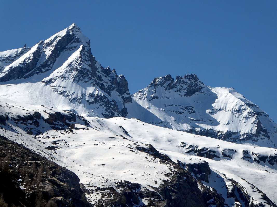
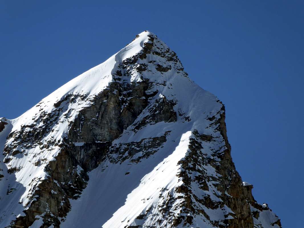
This beautiful and imposing pyramid belongs to the Gran Paradiso Group, forming a triptych with Tresenta (3.609m) and Ciarforon (3.642m). Here we describe a route on the North Face, while the Normal Route via the Northeast Ridge to the Colle del Ciarforon (3.317m) and subsequent crossing on Northern Monciair Glacier is synthesized downhill. Historically speaking, it now has a fairly long history, which begins in the month of May 1920, and therefore just ended the First World War. The first to climb it are three Turin mountaineers who attempted the first direct ascension, as well as absolute of the wall; but they were repelled on the Northwest "Spigolo" or Corner by the excessive presence of the snow with verglass. On July 3, 1927, R. Chabod and F. De Rosa tried it, but due to the ice that was too hard (let's not forget that the tools were very different from the current ones at the time), they must, as Academician Renato Chabod says in the Guide of Mounts by Italy, Edit. CAI / TCI 1939, 1963 and 1980 "Gran Paradiso National Park", page147: 32db) VARIANT. - ... "It's just a loophole ...", abandon the actual wall, or at least leave out the main slide on the right (West) "taking refuge" with a traverse to the left. This variant, after passing the rocky rib that divides the two sectors, climbs up an icy gully placed between it and another secondary or lower rocky rib that flows into the NE ridge on the snowy saddle just beyond the "Gran Gendarme" . The same Chabod tries again on July 5, 1936, together with mountaineers Enrico Adami, Emanuele Andreis and Luigi Bon, all good icers: "32 da) DIRECT VARIANT ... go up the slope for about three quarters of its height, up to where that is a marked and comfortable horizontal ledge interrupts the continuity of the rocky bastion of the d. or. (orographic right NDR) ... along the ledge for 15 - 20 meters you reach the edge of the bastion and continue along it - rock and snow not too much steep - up to the snowy little crest in the shape of a reversed comma ... ". In a nutshell, they reach the triangular snowy slope below the NE Ridge above the previous variant. The subsequent attempt made on 9 August 1938 by L. Cottafavi and L. Santurini ends with a reverse variant of the previous attempts: the same in practice go up along the right or western edge of the icy slope and then conclude on the shoulder of the NW Ridge. .. that is, the route of August 1897 by the Londoner George Yeld with the Guide of Valtournenche Sylvain Pession. Another more important attempt but still requiring a new retreat or ulterior variant was made on 14 July 1974 by G. De Agostini, A. Migliari and M. Sartori, but it ended, after having passed the lowest part of the dividing rocky rib, reuniting above with the variant of july 1936. The problem of the completely direct ascent, then comprensive of the last rocky strech more difficult, was solved by the Pian Felina mountaineers Osvaldo Cardellina and Camillo Roberto Ferronato who, on 20 July 1980, centrally climbed the terminal bastion, exiting directly to the Top. Their choice was forced, since the glacial slope formed by snow not transformed at all and the very soft weather with a rather high temperature forced them to make this obliged choice due to the excessive danger of the same (see various photos on the page). It is certainly a coveted ascension which, unfortunately due to the retreat of the ice, has recently lost in attraction, therefore comprensive of the last strech more difficult even if not always with good conditions of rock. So nowadays this ice climbing is certainly more exposed to stone discharges, due to the lack of the permafrost glue.
The triangular and exclusively rocky West Wall rises, between the Northwest "Spigolo" and the South-Southwest Ridge, which rises from Colle di Monciair, is for almost 500 meters above the Breuil Glacier, offering an idea of large compact wall; in reality it can be divided into three sections and sectors, of which the really compact one is the rocky "shield" positioned in the center. The other two sides have rocks, although still quite difficult, but somewhat more broken. As well as all the basal base formed by several horizontal steps which, with a diagonal ascent from Northwest to Southeast, can be crossed, taking advantage of the first more great ledge, for the alternative climb to the Colle, or rather Colletto di Monciair having exclusively mountaineering importance (3.297/8 m) as performed by Giovanni Bobba, Luigi Vaccarone and P. Re Fiorentin with the guide of Rhêmes Casimiro Thérisod on 10 August 1891. While the "central shield" still remains inviolate, the left sector, or more Northern, was the first route built on the wall by Remo Chabod with E. Martino on 31 August 1936; another route, but "mixed", because it uses the Northwest "Spigolo" otherwise an Edge in the final part, was opened even further to the left by the roped composed of C. Durando, F. Galliano, G. Del Santo P. and S. Giacoletto and G . Sereno (which in the final stretch was divided into two different itineraries) on 27 September 1970. The right sector, more Southern and that is between the "central shield" and the South-southwest Crest, was instead climbed by Osvaldo Cardellina, Marco Cossard and Giuseppe Lamazzi on 5th July 1983 and presents a less difficult route than the previous ones, bypassing the "shield" in the final part to conclude with the crest mentioned above. The Eastern side, on the other hand, has a completely different structure and, besides being less difficult, certainly much less elegant. Analyzing it, we find an East Face, moreover divided into two parts of which the Northern snowy one and the rocky Southern one, facing over the homonymous Broglio Glacier; therefore with Italian wording, but in the Canavese area in North-northwestern Piedmont. The same is faced for the first time on 12 July 1923 by Ester della Valle di Casanova, Gigetta Matricardi with the Milan mountaineer, at that time of well-known classic mountaineering, Aldo Bonacossa; it is a longer than not difficult climb (about 600 meters), which starts at an altitude of about 2.950 meters, that is where this rocky spur plunges into the lower and more SW part of the glacier. It is also reported a possibility of rapid descent just North of the rocky ridge, such that, according to the authors, it could, after the first about 50 meters below the Summit, allow a quiet slide on the less noble parts up to the glacier. But from this climb the Bonacossa sees the opportunity to climb the nearby SE Face, which he climbs just the following week with A. Sarfatti. They trace a somewhat strange and "lopsided" route, because, from the detrital ledges of the Colletto di Monciair, they climb easily but sideways to the Summit. The thing is, at least partially, "straightened" by Don P. Solero who with B. Guglielmetti on 18 September 1940 carried out a direct route in the middle. In truth, theirs too is a bit of a makeshift route, because, after having attacked on the left at the large boulder at the base of the gully that leads to the Colletto di Monciair, they still go up deviating to the right, so much so that they end up on the Eastern "Crestone" at about 100 meters from the Top. Given the four sides (North, West and East which is double, ie SE and NW) it remains to take a look at the ridges: already mentioned of the "Spigolo" NW of 1897 and of the "Crestone" East of 1923, we must observe the S -SO Ridge, which descends to the Colletto di Monciair separating this Cima from the Denti del Broglio (3.454m) and the NE Crest which leads to the Colle del Ciarforon (3.417m) and to the Summit of the same name (3.642m). The first was climbed on 11 July 1921 by Aldo Bonacossa (who can therefore be considered the "King of the Monciair") together with Maria Sbrojavacca and is to be considered as a fun but demanding climb, even if it bypasses some difficult sections in its route, on rock however good. The second constitutes the Normal Via from the Aosta's Valley side or from Pont Valsavaranche location and Vittorio Emanuele Shelter. It was presumably traveled by Martino Baretti and A. Blanchetti in 1867, while the first certain ascension is that of G. Frasca with G. Blanchetti on July 14, 1881. It is a simple and easy climb (it is almost more complicated to reach Ciarforon's Pass above Glacier de Monciair or Montchair in case of verglass presence) which linearly leads to the Top, bypassing on the right (West) the "Gran Gendarme" (3.378m). A curiosity: prior to 1926 the mountaineer P. Filippi crossed it in its entirety, thus making the first full ascension.
Questa tanto bella quanto imponente piramide appartenente al gruppo del Gran Paradiso, forma un trittico con La Tresenta (3.609 m) ed il Ciarforon (3.642 m). ne descriviamo la Via sulla Parete Nord, mentre la Via Normale tramite la Cresta Nordest al Colle del Ciarforon (3.317 m) e susseguente traversata del Ghiacciaio Settentrionale di Monciair viene sintetizzata in discesa. Storicamente parlando, ormai la medesima possiede un'abbastanza lunga storia, che prende inizio nel mese di maggio del 1920, quindi appena finita la Prima Guerra Mondiale. A scalarla per primi sono tre alpinisti torinesi che tentarono la prima ascensione diretta, oltreché assoluta della parete; ma vennero respinti sullo Spigolo Nordovest dall'eccessivo innevamento con verglass o ghiaccio-vetro. Il 3 Luglio 1927 ci provano R. Chabod e F. De Rosa che però, a causa del ghiaccio troppo duro (non dimentichiamoci che gli attrezzi erano al tempo ben diversi da quelli attuali), devono, come scrive l'Accademico Renato Chabod nella Guida dei Monti d'Italia, Edit. CAI/TCI 1939, 1963 e 1980 "Gran Paradiso Parco Nazionale", pagina147: 32db) VARIANTE . - ..."Non é che una scappatoia ...", abbandonare la parete vera e propria, o perlomeno tralasciare lo scivolo principale di destra (Ovest) "rifugiandosi" con una traversata a sinistra. Questa variante, superato il costolone roccioso atto a dividere i due settori, risale per un canalino ghiacciato posto tra la medesima ed un'altra costola rocciosa secondaria od inferiore sfociante sulla Cresta NE sulla sella nevosa appena oltre il "Gran Gendarme". Il medesimo Chabod ci riprova il 5 Luglio 1936, insieme agli alpinisti Enrico Adami, Emanuele Andreis e Luigi Bon, tutti buoni ghiacciatori: "32 da) VARIANTE DIRETTA ... risalire il pendio per tre quarti circa della sua altezza, fin dove cioé una marcata e comoda cengia orizzontale interrompe la continuità della bastionata rocciosa della sponda d. or. ... percorrendo la cengia per 15 - 20 metri si raggiunge l'orlo della bastionata e per esso si continua - roccia e neve non troppo ripido - fino alla crestina nevosa a forma di virgola rovesciata ...". In poche parole, raggiungono il pendio nevoso triangolare sottostante la Cresta NE al di sopra della variante precedente. Il successivo tentativo effettuato il 9 Agosto 1938 da parte di L. Cottafavi e L. Santurini si conclude con una variante al rovescio dei precedenti tentativi: gli stessi in pratica risalgono lungo il margine destro od Occidentale dello scivolo per poi concludere sullo spallone della Cresta NO, cioé la via dell'agosto 1897 ad opera del londinese Geoige Yeld con la Guida di Valtournenche Sylvain Pession. Altro tentativo più importante ma pur sempre richiedente un ripiego viene effettuato il 14 Luglio 1974 da parte di G. De Agostini, A. Migliari e M. Sartori, conclusosi, dopo aver superato la parte più in basso della costola rocciosa divisoria, riunendosi in alto alla variante del luglio del 1936. Il problema della salita completa e diretta venne risolto da parte degli alpinisti di Pian Felina Osvaldo Cardellina e Camillo Roberto Ferronato che, in giornata del 20 Luglio 1980, suiperarono nel mezzo la bastionata finale uscendo direttamente in Vetta. Scelta forzata la loro, poiché il pendio glaciale formato da neve per nulla trasformata ed il tempo molto molle con temperatura elevata li costrinsero ad effettuare questa scelta obbligata a causa dell'eccessiva pericolosità del medesimo (vedi varie foto in pagina). Trattasi sicuramente d'ascensione ambita che, purtroppo a causa del ritiro dei ghiacci, ultimamente ha perso in attrazione, dunque comprensiva inoltre dell'ultimo tratto roccioso sicuramente più difficile anche se non sempre su roccia buona. Oggigiorno risulta più esposta alle scariche di pietre.
La triangolare e quasi esclusivamente rocciosa Parete Ovest si innalza, compresa tra lo Spigolo Nordovest e la Cresta Sud-sudovest che sale dal Colle di Monciair, per quasi 500 metri al di sopra del Glacier du Breuil offrendo un'idea di grande parete compatta; in realtà la si può dividere in tre sezioni e settori, dei quali quello veramente compatto risulta lo "scudo" roccioso posizionato al centro. Gli altri due laterali presentano rocce, pur sempre abbastanza difficili, ma alquanto più rotte. Così come tutto lo zoccolo basale formato da diversi gradoni orizzontali che, con salita diagonale da Nordovest a Sudest possono essere attraversati, sfruttando il primo cengione, per la salita alternativa al Colle, o meglio Colletto di Monciair avendo quest'ultimo esclusivamente importanza alpinistica (3.297/8 m) come effettuato da Giovanni Bobba, Luigi Vaccarone e P. Re Fiorentin con la Guida di Rhêmes Casimiro Thérisod il 10 Agosto 1891. Mentre il più compatto "scudo centrale" rimane ancora inviolato, il settore di sinistra, o maggiormente Settentrionale, ha costituito la prima via realizzata sulla parete da parte di Remo Chabod con E. Martino il 31 Agosto del 1936; un'altra via, ma "mista", perché utilizza lo Spigolo Nordovest nella parte finale, é stata aperta ancora più verso sinistra dalla cordata composta da C. Durando, F. Galliano, G. Del Santo P. ed S. Giacoletto e G. Sereno (che nel tratto terminale si é divisa con due itinerari diversi) il 27 Settembre 1970. Il settore destro, più Meridionale e cioé compreso tra lo "scudo centrale" e la Cresta Sud-sudovest, é stato invece salito da Osvaldo Cardellina, Marco Cossard e Giuseppe Lamazzi il 5 Luglio 1983 e presenta una via sicuramente meno difficile delle precedenti, aggirando lo "scudo" roccioso di mezzo nella parte finale per concludere con la cresta di cui prima. Il Versante Orientale invece presenta una struttura completamente diversa e, oltreché meno difficile, sicuramente molto meno elegante. Analizzandolo, troviamo una Faccia Est, tralaltro divisa in due parti delle quali quella Settentrionale nevosa e la Meridionale rocciosa, rivolto sopra l'omonimo Ghiacciaio del Broglio; quindi con dicitura italiana, ma nell'area del Canavese in Piemonte di Nord-nordovest. Il medesimo viene affrontato per la prima volta il 12 Luglio 1923 da parte di Ester della Valle di Casanova, Gigetta Matricardi con l'alpinista milanese, a quei tempi dell'alpinismo classico ben conosciuto, Aldo Bonacossa; é una salita più lunga che non difficile (circa 600 metri), che prende l'avvio a quota 2.950 metri circa metri, cioé laddove questo sperone roccioso si immerge nella parte inferiore e più a SO del ghiacciaio. Viene inoltre segnalata una possibilità di discesa rapida appena più a Nord del costolone roccioso, tale che, a detta degli autori, potrebbe, dopo i primi circa 50 metri sottostanti la Sommità, permettere una tranquilla scivolata sulle parti meno nobili fin sul ghiacciaio. Ma da questa salita il Bonacossa intravvede l'opportunità di salire la vicina Parete SE, che va a scalare giusto la settimana successiva con A. Sarfatti. Tracciano una via un pò strana nonché "sbilenca", perché, dalle cenge detritiche del Colletto di Monciair, salgono facilmente ma di traverso alla Vetta. La cosa viene, almeno parzialmente, "raddrizzata" da Don P. Solero che con B. Guglielmetti il 18 settembre 1940 effettuano nel mezzo una via diretta. Per la verità anche la loro é un pò una via di ripiego, perché, dopo aver attaccato sulla sinistra presso il gran masso alla base del canalone che porta al Colletto di Monciair, pur sempre salgono deviando sulla destra, tanto da concludere sul Crestone Orientale a circa 100 metri dalla Vetta. Visti i quattro versanti (Nord, Ovest ed Est che risulta doppio, cioé SE e NO) rimane da dare un'occhiata alle creste: detto di già dello Spigolo NO del 1897 e del "Crestone" Est del 1923, dobbiamo osservare la Cresta S-SO che scende al Colletto di Monciair separando questa Cima dai Denti del Broglio (3.454 m) e la Cresta NE che si indirizza al Colle del Ciarforon (3.417 m) ed all'omonima Vetta (3.642 m). La prima é stata salita lo 11 Luglio 1921 da Aldo Bonacossa (che quindi può essere considerato il "Re del Monciair") insieme a Maria Sbrojavacca ed é da considerarsi come una salita divertente ma impegnativa, anche se aggira alcuni tratti nel suo percorso su roccia comunque buona; la seconda costituisce la Via Normale dal versante valdostano ovvero da Pont Valsavaranche e Rifugio Vittorio Emanuele. Venne percorsa presumibilmente da Martino Baretti ed A. Blanchetti nel 1867, mentre la prima ascensione certa risulta quella di G. Frasca con G. Blanchetti il 14 Luglio 1881. Si tratta di una salita semplice e facile (é quasi più complicato raggiungere il Colle del Ciarforon sopra il Glacier de Monciair oppure Montchair in caso di presenza del verglass) che linearmente conduce al Sommo, aggirando sulla destra (Ovest) il "Gran Gendarme" (3.378 m). Una curiosità: anteriormente al 1926 l'alpinista P. Filippi attraversò integralmente lo stesso, compiendo quindi la prima ascensione integrale.
First Ascents
N-E Ridge: G. Frasca and G. Blanchetti, (Jul 14th, 1881) - (first known ascent).
N-W Arête: George Yeld with François. and Sylvain Pession, (Aug 10th, 1897).
S-SW Ridge: Maria Sbrojavacca and Aldo Bonacossa, (Jul 11th, 1921).
W Wall (Left or Northern Side): E. Martino with Remo Chabod, (Aug 31th, 1936).
W Wall (Right or Southern Side) and S-SW Ridge in final part: Osvaldo Cardellina, Marco Cossard and Giuseppe Lamazzi, (Jul 05th, 1983).
N Wall: E. Barisone, S. Gallo and M. Strumia, (May 02th, 1920).
N Wall (Superdirect Route with variant on exit out directly to Top): Osvaldo Cardellina and Camillo Roberto Ferronato, (Jul 20th, 1980).
N Wall (of Ciarforon with SW Wall in descent and crossing to Becca di Monciair): Ilario Antonio Garzotto and Osvaldo Cardellina, (Jul 16th, 1967).
N Wall and N Wall of Ciarforon: Ruggero Busa, Osvaldo Cardellina, Ilario Antonio Garzotto and Vito Favre, (Jun 22th, 1969), two walls in day.
E Ridge: Ester della Valle di Casanova, Gigetta Matricardi and Aldo Bonacossa, (Jul 12th, 1923).
S-E Wall: Aldo Bonacossa and A. Sarfatti, (Jul 19th, 1923).
Getting There
BY CAR:
From France: through the Mont Blanc Tunnel or the Col du Petit Saint Bernard: you can drive on SS.26, following directions for Aosta and, before arriving in Villeneuve, turn right towards Introd. Alternatively, you can take Motorway A5 (at Courmayeur or Morgex) and exit at Aosta Ovest.
From all the other directions: get to the Aosta Ovest exit of Motorway A5. Then drive on SS.26 Aosta, in the direction of Courmayeur; just after Villeneuve turn left towards Introd.
BY PLANE:
Aeroporto "Corrado Gex" Saint Christophe (Aosta).
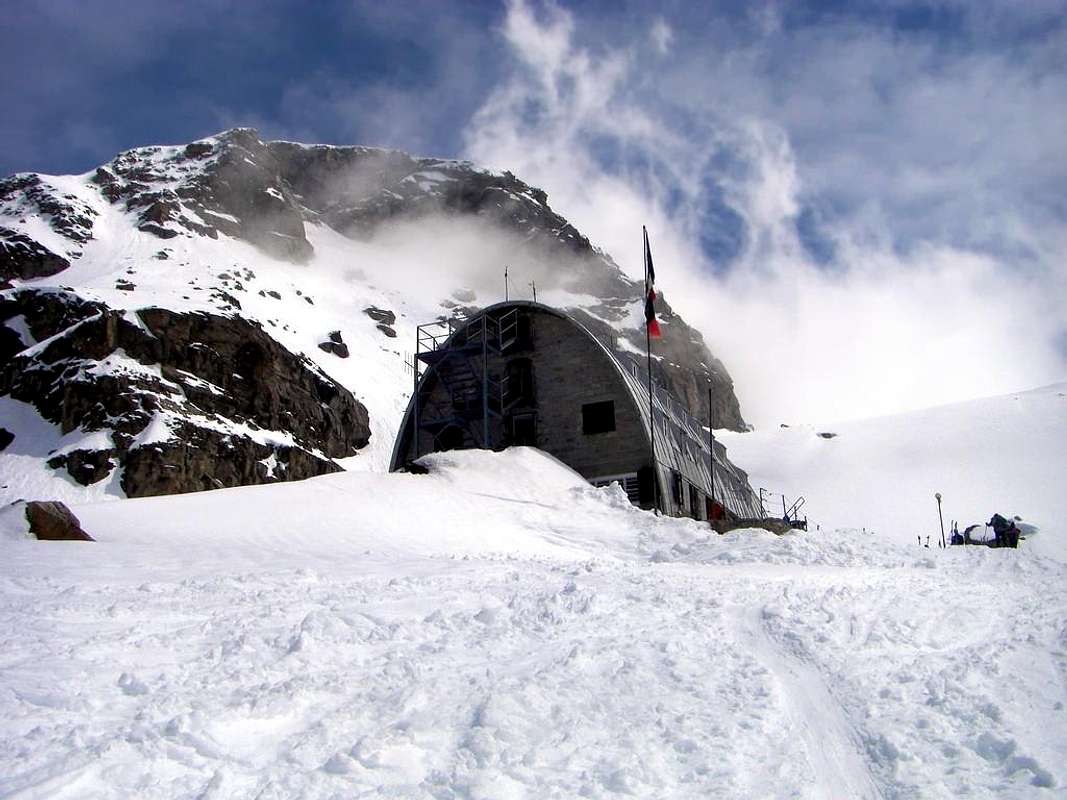
Shortly after Introd, you arrive at a junction: turn left, entering Valsavarenche, and passing through many Villages (Degioz, Eaux Rousses, etc.) you can arrive at Pont (1.960m) where the road ends. The ascent to Becca di Monciair is usually done in two stages: on the first day you follow the normal route to Gran Paradiso and gain 770m of elevation from Pont (1.960m) to Rifugio Vittorio Emanuele (2.730m). The second day is spent on the climb to the summit.
Route
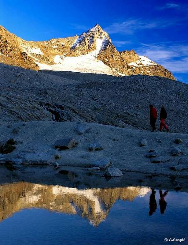
From Rifugio Vittorio Emanuele II° (2.730m) traverse the Moncorvé Glacier, losing at first some elevation. Skirting Ciarforon, reach the northern Monciair Glacier; cross the glacier and aim for the slender triangular North Face (2h'00). Climb the moderate lower slopes until the bergschrund, which usually poses no difficulties. Proceed to the upper slopes at about 3.200m. The angle varies between 45 and 50 degrees. Keep initially at some distance from the rocky rib on the left, which forms a giant S on the face. Gradually approach the rib so as to attain it when you reach the upper part of the face. From there there are two options. You can continue along the rib (direct route). Alternatively, you can almost angle right toward the Northwest Ridge. This second option is faster and easier, but you should pay attention to the final brocken rocks if they are covered by snow. In both cases, you reach the summit of the pyramid at (3.544m). (About 3 hours, difficulty from PD to AD, depending on the conditions).
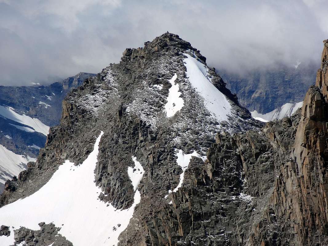
DESCENT through Northeast Crest or Standard Route: Descend to Colle del Ciarforon (3.317m) along the Northeast Ridge (Normal Route) along enough easy rocks and snowfields. Skirt on the West side the thirty meter Gendarme. From there descend a rather steep slope that takes you back to the northern Monciair Glacier. This slope has some crevasses. Once on the glacier, retrace your steps towards Rifugio Vittorio Emanuele II°.
Dal Rifugio Vittorio Emanuele II° (2.730 m) attraversare il Ghiacciaio di Moncorvé, perdendone in un primo momento un po' di elevazione. Scartando il Mont Ciarforon, raggiungere il Ghiacciaio Settentrionale di Monciair; attraversarlo puntarndo in direzione della slanciata nonchè triangolare Parete Nord (2h'00). Salire i moderati pendii fino alla crepaccia terminale, che solitamente non presenta alcuna difficoltà. Procedere sul superioriore scivolo sino a circa 3.200m . L'angolazione della pendenza può variare tra i 45° ed i 50° gradi. Mantenersi inizialmente a una certa distanza dalla nervatura rocciosa sulla sinistra, che forma una grande S sulla parete. A poco a poco avvicinarsi alla costola in modo da ricongiungersi con la parte superiore della faccia. Da quel punto sussistono due opzioni. È possibile proseguire lungo la costola con percorso diretto od, in alternativa, "tagliare" quasi ad angolo retto verso la Cresta Nordovest. Questa seconda opzione è più veloce e più facile, ma si dovrebbe prestare attenzione alle rotte rocce finali qualora fossero ricoperte dalla neve. In entrambi i casi, si raggiunge la vetta della piramide a (3.544 m). (Circa 3 ore, difficoltà dal PD a AD, a seconda delle condizioni dell'innevamento o dalla presenza di ghiaccio vivo).
DISCESA tramite la Cresta Nordest o Via Normale: Si scende al Colle del Ciarforon (3.317 m) lungo la Cresta Nordest o Via Normale lungo le rocce e nevai di abbastanza facile percorrenza, quasi subito scartando sul lato Ovest il Gendarme di 30 metri. Da qui si scende tramite un pendio piuttosto ripido che riporta indietro verso il Ghiacciaio Settentrionale di Monciair. Questa tratto può presentare alcuni crepacci. Una volta sul ghiacciaio, ripercorrere la strada verso il Rifugio Vittorio Emanuele II°.
Difficulties & Equipment
Difficulties This route, in respect of NE Ridge or Normal Route, can be considered F+ with a brief step, if in verglass, of PD- under Ciarforon's Pass.
L'itinerario, rispetto alla Cresta NE ovvero Via Normale, è classificato F+ con un breve passaggio, se in ghiaccio vivo, di PD- sotto il Colle del Ciarforon.
Equipment Hiking gear For mountaineering with ice-axe, crampons and rope, above all in the crossing of Monciair's Glacier.
Da alpinismo con piccozza e ramponi nonché corda necessaria, soprattutto nell'attraversamento del Glacier de Monciair.
Red Tape
There are no fees or permits. Parking in Pont, at the start of the route to Vittorio Emanuele II Refuge, is free and there are no limitations for climbing and hiking. Remember that free camping is forbidden (except for emergency reasons, over 2.500 meters, from darkness until dawn). The whole region is part of the Parco Naturale del Gran Paradiso and thus you should take care of Nature as usual within the boundaries of natural parks.
Non sussistono tasse o permessi. Il Parcheggio a Pont di Valsavarenche, all'inizio della mulattiera per il Rifugio Vittorio Emanuele II°, è gratuito e non ci sono limitazioni per lo svolgimento sia dell'arrampicata che nei confronti dell'escursionismo. Ricordate che il campeggio libero è vietato (se non per motivi d'emergenza, oltre i 2.500 metri, dalle tenebre fino all'alba). L'intera regione è facente parte del Parco Naturale del Gran Paradiso, e quindi ci si deve prender cura della Natura come di consueto all'interno dei confini di parchi naturali.
When To Climb
The best time is obviously July through September. Most ascent routes to the summit include glaciers so you need crampons anyway.
Accomodations
Accomodations can be found in all Villages of Valsavarenche. You can use Rifugio Vittorio Emanuele as base for the ascents to both Gran Paradiso, Ciarforon and Becca di Monciair. In addition there are several campgrounds in Valsavarenche, one of which just near the trailhead. Telephone Numbers: Tourist information "Comunità Montana Gran Paradiso" 0165/95055. Union of Mountain Guides (Valle d'Aosta)0165/44448.
"Guida delle Alpi Occidentali" di Giovanni Bobba e Luigi Vaccarone C.A.I. Sezione di Torino Volume II (parte II), 25 Maggio 1896.
"Guida dei Monti d'Italia-Gran Paradiso Parco Nazionale" E. Andreis, R. Chabod, M. C. Santis, Club Alpino Italiano/Touring Club Italiano, prima Ed. 1939; seconda Ed. 1963; terza Ed.
"Guida della Regione Autonoma Valle d'Aosta" di Mario Aldrovandi, Ed. S.P.E. di Carlo Fanton, Torino 31 Dicembre 1964.
"Rifugi e bivacchi in Valle d'Aosta", di Cosimo Zappelli aggiornata da Pietro Giglio, Musumeci Editore, Luglio 2002.
"Diari Alpinistici" di Osvaldo Cardellina e Indice Generale accompagnato da Schedario Relazioni Ascensioni 1964-2021 (inediti).
"80 itinerari di Escursionismo Alpinismo e Sci Alpinismo in Valle d'Aosta", di Osvaldo Cardellina, Ed. Musumeci, Giugno 1977 (in Italian); seconda Ed. Luglio 1981; terza Ed. Luglio 1984; (in French), prima Ed. Febbraio 1978; seconda Ed. Marzo 1980.
MAPS:
Kompass "Gran Paradiso Valle d'Aosta Sentieri e Rifugi" Carta Turistica 1:50.000.
Enrico Editore Ivrea-Aosta "Gruppo del Gran Paradiso" 1:50.000.
L'Escursionista "Valle di Cogne Carta dei Sentieri" (n° 10) 1:25.000.
L'Escursionista "Tour de la Vallée de Cogne Grand Paradis" Carta dei sentieri 1:25.000.
I.G.C. Istituto Geografico Centrale Carta dei sentieri e dei rifugi "Valsavarenche-Val di Rhêmes-Valgrisenche" 1:25.000.
I.G.C. Istituto Geografico Centrale-Carta dei sentieri e dei rifugi "Grivola-Gran Paradiso" 1:25.000.
A.I.NE.VA. (Associazione Interregionale Neve e Valanghe).
Useful numbers
Protezione Civile Valdostana località Aeroporto n° 7/A Saint Christophe (Ao) Tel. 0165-238222.
Bollettino Meteo (weather info) Tel. 0165-44113.
Unità Operativa di Soccorso Sanitario Tel. 118.
Acknowledgements
I want to thank my three SP friends who respectively helped me to prepare the text (Livioz and Gangolf) and mainly to translate it in English (Brenta) and my friend Osvaldo for the Overview text and translation into the English and into the Italian for the other sections.
Children refers to the set of objects that logically fall under a given object. For example, the
Aconcagua mountain page is a child of the 'Aconcagua Group' and the 'Seven Summits.' The
Aconcagua mountain itself has many routes, photos, and trip reports as children.
Parents refers to a larger category under which an object falls. For example, theAconcagua mountain page has the 'Aconcagua Group' and the 'Seven Summits' asparents and is a parent itself to many routes, photos, and Trip Reports.

 17557 Hits
 96.25% Score
 58 Votes