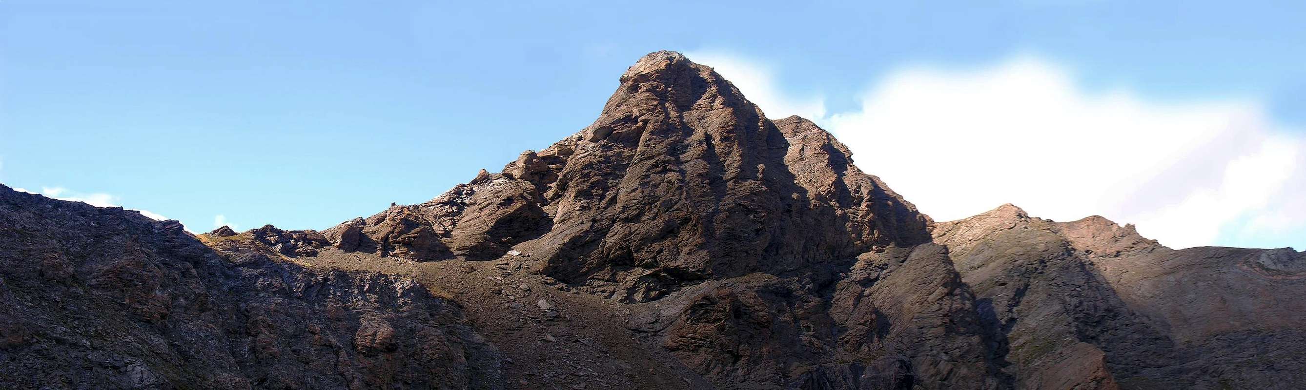
This mountain is located on the foothills along the watershed between the Valley of Saint Marcel (West) and Fénis/Clavalité/Upper Comba Tersiva (East), descending from the Punta Tersiva (3.515m), splits into two to Punta del Tessonet (3.266m), a branch proceeds to the Northwest in the direction of Point Gianni Vert, the two of Laval, and the Pass of Saint Marcel also called Coronas, where originates the Group of Mount Emilius, a second, however, descends steeply to the North and, after a liquid winding between Little and Great Avert, returns to the North forming in the progression Great Crest, Point of Plan Rué and Mount Corquet, ending finally, above the Hamlets of Les Druges High and Low, with Mont Roux, home to the ancient mines of copper and iron. More precisely, the Petit Avert is located between the Pass of Lavodilec (2.863m) to the South and Pass 2.827 meters, but without a name on the spot called Terre Bleue for the bluish color of its rocks and groundwater moraine just below, to North; latter separates it from the Grand Avert (2.991m), but not by much higher that the "hidden" from view making it slightly distinguishable from afar. This mountain also has a mass and a significant extension more than the Grand Avert, which gives its name to this small Subgroup. Is characterized by a long ridge to the East-northeast directed that contains the beautiful Lake Lavodilec (2.357m), a Southwest Ridge, shorter, descending the Pass with a West-northwest Ridge that descends in the direction of the Petite Chaux Pastures (2.419m) in the Upper Valley of Saint Marcel and a last revolt in the North-northeast suitable to connect it to the Great Avert. Logically, there are just as slopes, all formed by the steep slopes of broken rock, fragile, debris or block, often covered with grass layers, which are not safe for climbing. Mountain is poorly attended, especially for the long approaches that both Les Druges in the Municipality of Saint Marcel, who Barche-Lovignana, where there is a ban on the farm, in the Valley of Fénis/Clavalité/High Comba Tersiva. Views of the surrounding mountains, especially in Grain Peak, Emilius's Red Points, Emilius and Range of the Roèses, while Tersiva remains "hidden" from the nearby Point of Tessonet; frontally, but in the distance, it unfolds the Mountain Chain of the Pennine Alps along the wide watershed between Italy and Switzerland.
Questa montagna è posizionata sul lungo contrafforte spartiacque tra il Vallone di Saint Marcel (Ovest) e quello di Fénis/Clavalité/Alta Comba Tersiva (Est) che, scendendo dalla Punta Tersiva (3.515 m), si sdoppia alla Punta del Tessonet (3.266 m); un ramo procede a Nordovest in direzione della Punta Gianni Vert, delle due di Laval e del Colle di Saint Marcel o Coronas, ove trae origine il Gruppo del Monte Emilius; un secondo, invece, discende decisamente a Nord e, dopo un'ansa sinuosa tra Petit e Grand Avert, ritorna a Settentrione formando in progressione la Grande Cresta, la Punta Plan Rué ed il Mont Corquet, terminando infine, sopra i Villaggi di Les Druges Alte e Basse, con il Mont Roux, sede di antiche miniere di rame e di ferro. Più precisamente, il Petit Avert è collocato tra il Colle di Lavodilec (2.863 m) a Sud ed il Colle 2.827 metri, senza nome ma in loco chiamato di Terre Bleue per il colore bluastro delle sue rocce, nonché delle falde moreniche appena sottostanti, a Settentrione; questo ultimo lo separa dal Grand Avert (2.991 m), non di molto più elevato ma che lo "nasconde" alla vista rendendolo poco distinguibile da lontano. Questa montagna, inoltre, presenta una massa ed un estensione più notevoli rispetto al Grand Avert, che dona il nome a questo piccolo Sottogruppo. Risulta formata da una lunga cresta rivolta ad Est-nordest che contiene lo splendido Lago di Lavodilec (2.357 m), una Cresta Sudovest, più breve, che scende all'omonimo colle, una Cresta Ovest-nordovest che scende in direzione degli Alpeggi di Petite Chaux (2.419 m) nell'Alto Vallone di Saint Marcel e da un'ultima rivolta a Nord-nordest atta a collegarlo al Grand Avert. Logicamente, altrettanti sono i versanti, tutti formati da ripidi versanti di rocce rotte, fragili, detritiche od a blocchi, spesso ricoperte da strati erbosi, che ne sconsigliano l'arrampicata. Risulta montagna scarsamente frequentata, soprattutto per i più che lunghi avvicinamenti sia da Les Druges nel Comune di Saint Marcel, che da Barche-Lovignana, dove esiste il divieto di transito sulla poderale, nel Vallone di Fénis/Clavalité/Alta Comba Tersiva. Viste sulle montagne circostanti, soprattutto su Punta Garin, Punta Rossa dell'Emilius, Emilius e Catena delle Roèses, mentre la Tersiva rimane "occultata" dalla vicina Punta del Tessonet; frontalmente, ma in lontananza, si dispiega la Catena delle Alpi Pennine nel lungo spartiacque tra Italia e Svizzera.
First Ascents
First on the summit: Unknown.
In winter: Unknown.
South-southwest Edge: Osvaldo Cardellina and Nicola Colajanni, (Aug 17th, 2003), in ascent.
Getting There
BY CAR:
From Torino, Milano, etc: Motorway A5. Exit Aosta est For Grand Brissogne and Saint Marcel.
From Switzerland: through the Grand St. Bernard Tunnel or the homonym Pass. Drive to Aosta, For Grand Brissogne and Saint Marcel.
From France: through Mont Blanc Tunnel or Petit St. Bernard Pass. It isn't necessary to enter in Motorway A5, you can drive through SS.26 Aosta direction. Exit Aosta est For Grand Brissogne and Saint Marcel.
BY PLANE:
Aeroporto "Corrado Gex" Saint Christophe (Aosta).
Approaches
A) - From Saint Marcel: from the center of Saint Marcel follow the Regional Road (brown signs for the Pic Nic Area of Les Druges; 1.600 meters). Follow all the farm road, concomitant with the path n° 15, reach the junction between Grande and Petite Chaux at an altitude of 2.250 meters, just above Lake Layet (2.227m) to reach the path n° 15°/102 Petite Chaux (2.418m) and then the hill (2.863m; 4h'00/4h'30).
A) - Da Saint Marcel: dal centro di Saint Marcel seguire la Strada Regionale (cartelli colore marrone per l'Area Pic Nic di Les Druges; 1.600 metri circa). Seguire tutta la strada poderale che, concomitante con il sentiero n° 15, raggiunge il bivio tra Grande e Petite Chaux a quota 2.250 metri circa, appena al di sopra del Lago Layet (2.227 m); raggiungere con il sentiero n° 15°/102 Petite Chaux (2.418 m) e successivamente il colle (2.863 m; 4h'00/4h'30).
B) - From Fénis: by the city follow the signs (brown with indication boats; 607m) to the Valley Fénis/Clavalité/High Comba Tersiva. The ban is to continue Lovignana (1.169m) along the entire Vallone to Pasture Grand'Alpe (2.129m), through the local trail n° 2, from Grand Alpe continue diagonally with the path n° 7/102 with which you reach Lake Lavodilec (2.863m) and the overlying hill by a long diagonal to the West and over a rocky rampart (5h'00/6h'00 from the ban).
B) - Da Fénis: dal Comune seguire i cartelli (color marrone con indicazione Barche; 607 m) per la Valle di Fénis/Clavalité/Alta Comba Tersiva. Il divieto di proseguire si trova a Lovignana (1.169 m); percorrere tutto il Vallone fino all'Alpe Grand'Alpe (2.129 m), tramite il sentiero locale n° 2, da Grand Alpe proseguire in diagonale con il sentiero n° 7/102 con il quale si raggiunge il Lago di Lavodilec (2.863 m) ed il soprastante colle tramite un lungo diagonale verso Occidente e sopra uno spalto roccioso (5h'00/6h'00 dal divieto).
SMALL VARIATION DIRECT e TYPICAL NOTES By making a day trip from Lovignana, but did not reach Grand Alpe Pastures 1 Km. about before, immediately after the Alp di Meney Damon (1.952m), take just to right (West) a small shortcut reported that, with semi-circular course, the path reaches diagonally from Grand Alps exatcly at 2.100 meters. Be careful because he lives in the area "marassus collericum" adder, only present here in the Valley, the same, if molested, not afraid to attack, alone among the vipers, man. Typically stays in the grooves torrents dried, but it is not rare to meet in the first leg of the trail, where a beautiful stone staircase invites you to soak up the sun. Downhill, however, come to the pasture, run by a Professor of Mathematics Albanian with his Family, the same produce an excellent cheese "Fontina", which in 2005 won the First Prize in Aosta Valley, butter and delicious. They are friendly sales and with good price.
VARIANTINA DIRETTA e NOTE di COLORE Effettuando la gita in giornata da Lovignana, non raggiungere Grand Alpe bensì 1 Km. circa prima, subito dopo l'Alpe di Meney Damon (1.952 m), prendere sulla destra (Ovest) una piccola scorciatoia segnalata che, con percorso semi circolare, raggiunge il sentiero in diagonale da Grand Alpe esattamente a quota 2.100 metri. Bisogna fare attenzione perché in zona vive il "marasso collericum", solo qui presente in tutta la Valle; lo stesso, se molestato, non teme di attaccare, unica tra le vipere, l'uomo. In genere soggiorna nei solchi torrentizi essiccati, ma non é raro incontrarlo nel primo tratto del sentiero, ove una bella gradinata in pietra lo invita a prendere il sole. In discesa, invece, raggiungere l'alpeggio, gestito da un Professore di Matematica Albanese con la sua Famiglia; la stessa produce un ottimo formaggio "Fontina", che nel 2005 ha vinto il Primo Premio in Valle di Aosta, e del burro squisito. Sono amichevolmente in vendita e con buon prezzo.
Route
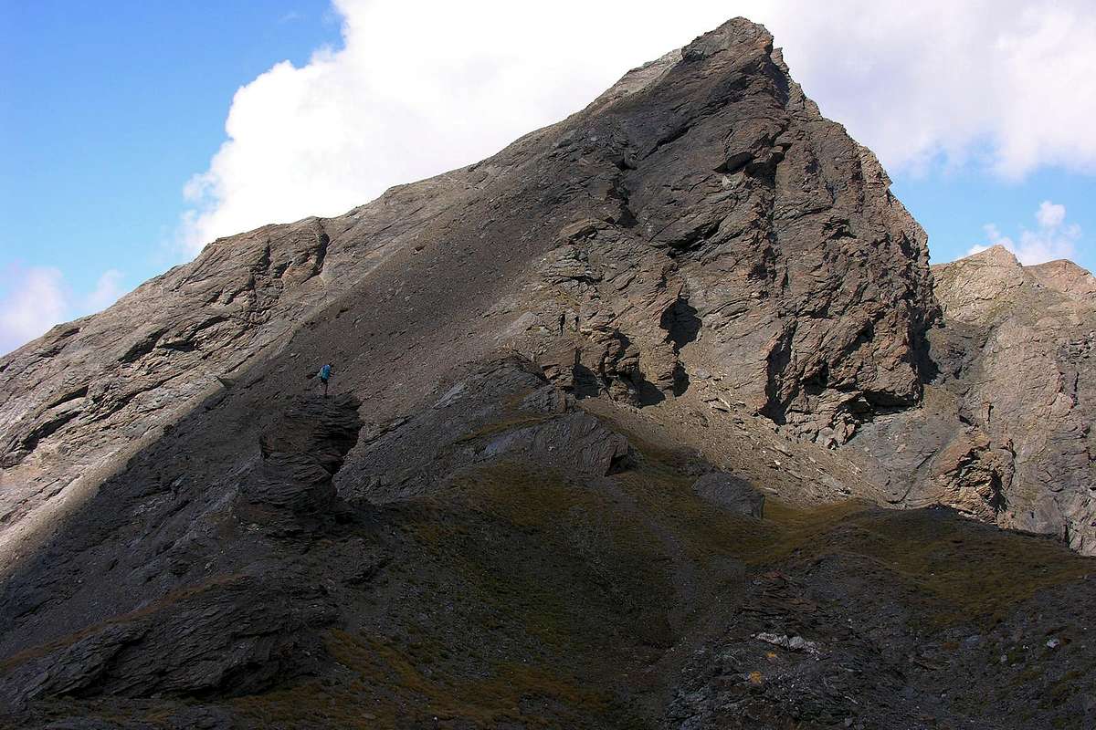
From Lavodilec Pass (2.863m), very good "salle à manger", follow to the North a tiny trace of debris, after leaving the left (west) of large and characteristic boulders; traced along the Southwest Slope remaining below the ridge through a small and slim trail-track. About fifty meters from the Summit bend slightly to the left and, again passing by evident signs, approach the final part of the West-northwest Ridge, reaching a small ledge. From here continue on the left up to a rock plate of a dozen meters (I°), and deal directly with an easy transition, but gentle to the fragility of the rock (I°+), exit on the crest above mentioned (traces of climb also on the same). Continue without any difficulty reaching the Top (0h'30/0h'45).
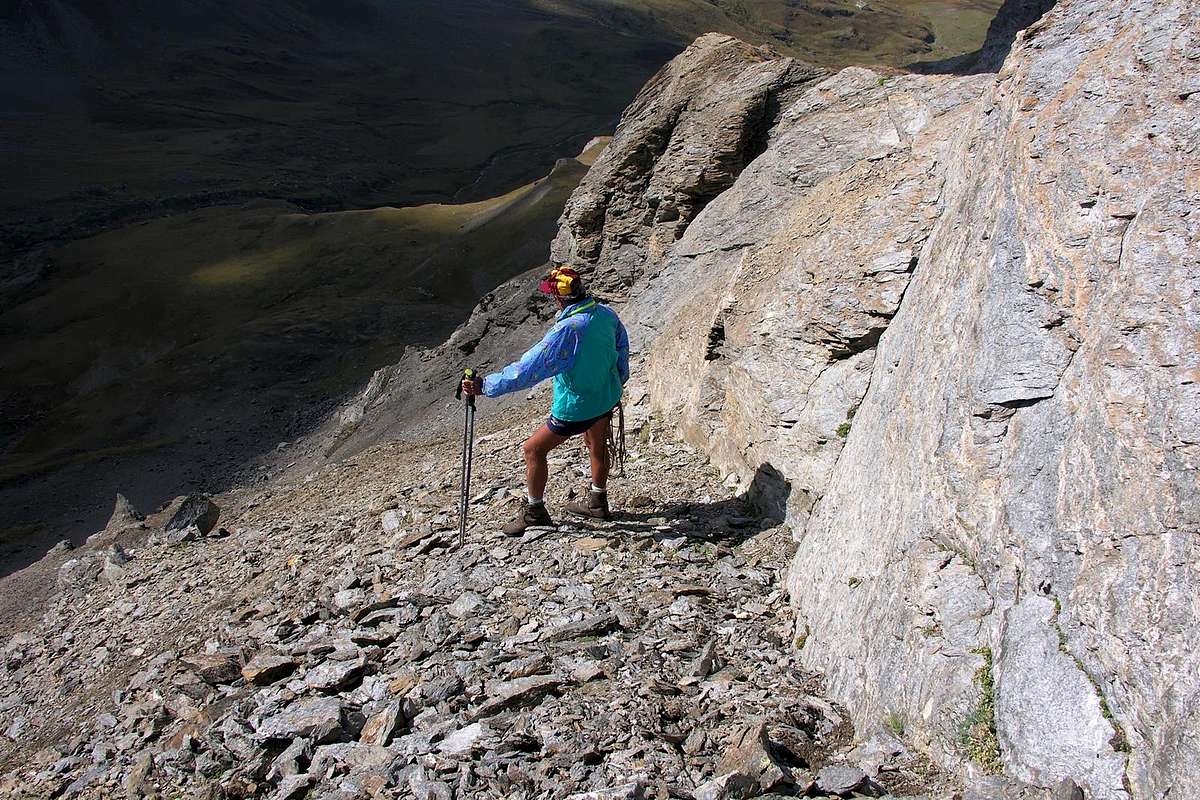
IN DESCENT: instead move towards the West-northwest crest, ascent, get off just to the left of this first on rocks a little steep, but broken, and then to a small couloir that turns into rocky debris alongside the rocks same (see photo) quickly reaching the track used for the climb.
Dal Colle di Lavodilec (2.863 m), ottima "salle à manger", seguire verso Settentrione una minuscola traccia su detriti, dopo aver lasciato alla sinistra (Ovest) dei grandi e caratteristici massi; risalire lungo il Versante Sudovest restando al di sotto della cresta tramite un'esile traccia. Ad una cinquantina di metri dalla Sommità piegare leggermente a sinistra e, sempre tramite evidenti segni di passaggio, avvicinarsi alla parte finale della Cresta Ovest-nordovest, raggiungendo una cengetta. Da questa continuare sulla sinistra fino ad una placca rocciosa d'una dozzina di metri (I°); affrontarla direttamente e con un passaggio facile, ma delicato per la fragilità della roccia (I°+), uscire sulla cresta sopra citata (tracce di salita anche sulla medesima). Continuare senza alcuna difficoltà raggiungendone la Cima (0h'30/0h'45).
IN DISCESA: invece di indirizzarsi verso la Cresta Ovest-nordovest, via di salita, scendere appena a sinistra di questa dapprima su rocce un poco ripide, ma rotte, e poi per un canalino che da roccioso si tramuta in detritico a fianco delle rocce medesime (vedi foto) raggiungendo in breve tempo la traccia usata per la salita.
"Guida delle Alpi Occidentali" di Giovanni Bobba e Luigi Vaccarone C.A.I. Sezione di Torino Volume II (parte II), 25 Maggio 1896.
"Guida dei Monti d'Italia – Emilius Rosa dei Banchi-Parco del Mont Avic" di Giulio Berutto e Lino Fornelli - Club Alpino Italiano/Touring Club Italiano, Marzo 2005.
"Guida della Regione Autonoma Valle d'Aosta" di Mario Aldrovandi; Ed. S.P.E. di Carlo Fanton, Torino 1964.
"Diari Alpinistici" di Osvaldo Cardellina e Indice Generale accompagnato da Schedario Relazioni Ascensioni 1964-2019 (inediti).
MAPS:
Kompass "Gran Paradiso Valle d'Aosta Sentieri e Rifugi" Carta Turistica 1:50.000.
L'Escursionista "Parco Naturale del Mont Avic" Carta dei sentieri 1:25.000.
L'Escursionista "Tour de la Vallée de Cogne Grand Paradis" Carta dei sentieri 1:25.000.
Hapax "Les Sentiers" Comunità Montana Monte Emilius, Luglio 2000 1:25.000.
Meridiani Montagne "Gran Paradiso" 1:25.000.
I.G.C. Istituto Geografico Centrale Torino "Il Parco Nazionale del Gran Paradiso" 1:50.000.
Studio F.M.B. "Gran Paradiso" Bologna 1:50.000.
Enrico Editore Ivrea-Aosta "Gruppo del Gran Paradiso" 1:50.000.
L'Escursionista "Valle di Cogne" Carta dei sentieri (n° 10) 1:25.000.
Parents refers to a larger category under which an object falls. For example, theAconcagua mountain page has the 'Aconcagua Group' and the 'Seven Summits' asparents and is a parent itself to many routes, photos, and Trip Reports.

 4585 Hits
 83.69% Score
 17 Votes