
-
 6718 Hits
-
 86.37% Score
-
 22 Votes
|
|
Mountain/Rock |
|---|---|
|
|
45.69800°N / 7.52589°E |
|
|
Mountaineering |
|
|
8802 ft / 2683 m |
|
|
Overview
Huge mountain well visible in the middle of Aosta Valley and overlooking the built up area of Fenis; it is the last summit of the left branch of the ridge coming down from Mont Glacier (3.186m). From its summit an extraordinary view on Dora Baltea River Basin.
Montagna massiccia e ben in vista nel centro della Valle d'Aosta dominante l'abitato di Fénis; è l'ultima cima del ramo di sinistra della costiera che trae origine dal Mont Glacier (3.186 m). Dalla sua vetta si ha una vista inconsueta sulla Valle della Dora Baltea.
First Ascents
- First in the summit: Unknown.
- In winter: Unknown.
Getting There
BY CAR:- From Torino, Milano, etc: Motorway A5. Exit Nus Village for Fénis Village.
- From Switzerland: through the Grand St. Bernard Tunnel or the homonym pass. Drive to Aosta, for Nus and Fénis.
- From France: through Mont Blanc Tunnel or Petit St. Bernard Pass. It isn't necessary to enter in Motorway A5, you can drive through SS.26 Aosta direction. Exit Nus Village and Fénis.
BY PLANE:
- Aeroporto "Corrado Gex" Saint Christophe (Aosta).
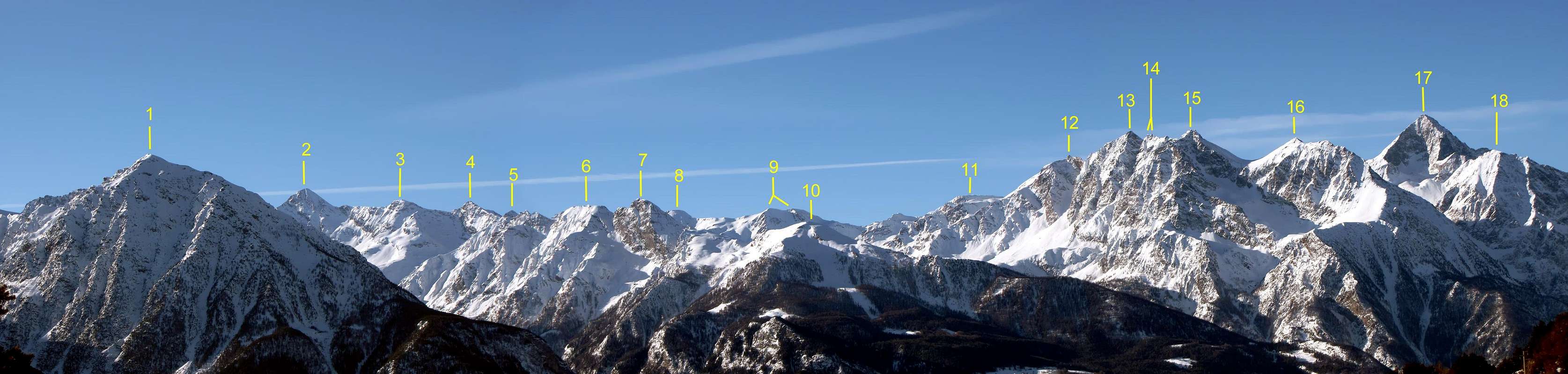
| (1) Pointe Chermontane (2.683m) | (2) Punta Tersiva (3.515m) | (3) Cresta del Tessonet (3.311m) |
| (4) Punta del Tessonet (3.264m) | (5) Grand Avert (2.991m) | (6) Grande Crête (2.908m) |
| (7) Punta di Plan Rué (2.883m) | (8) Punta Gianni Vert (3.148m) | (9) Punte di Laval (3.091m/3.102m) |
| (10) Mont Corquet (2.531m) | (11) Mont Vallonet (3.098m) | (12) Punta I. Antonio Garzotto (3.274m) |
| (13) Grande Roise (3.357m) | (14) Punta Gianni Junod (3.300m) | (15) Petite Roise (3.279m) |
| (16) Becca di Salè (3.137m) | (17) Monte Emilius (3.559m) | (18) Becca di Seneva (3.086m) |
Route
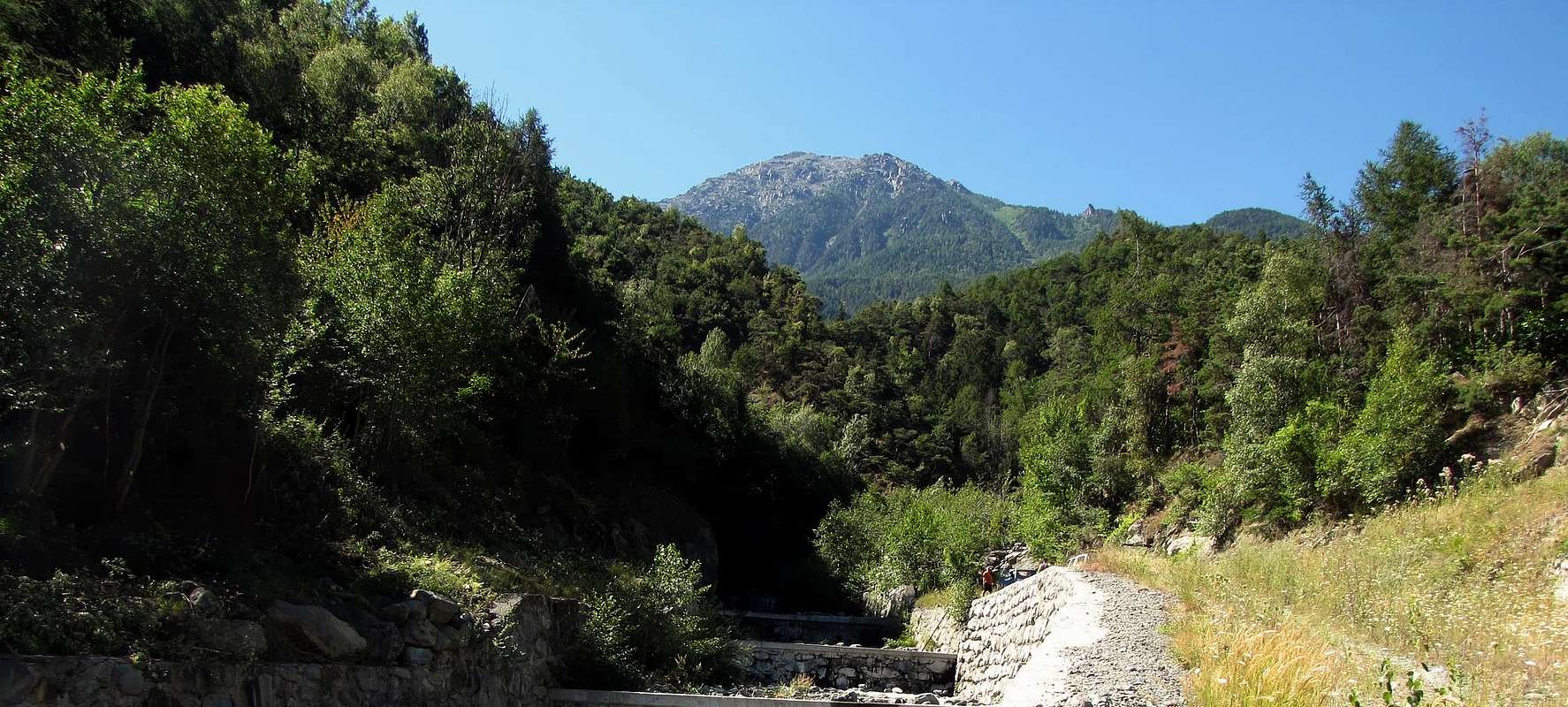
From Fénis (Barche Hamlet - 607m) follow the farm road for 9 km~ till the no access mark, beyond Lovignana (1.162m). On foot, bordering on the East side the Clavalitè Stream, up to a path (2a) near Alpe Fontana (1.279m) that toward SE, crossing the Bois de Marqueron up to a fork 1.823m, leads to the Piccola Bella Lana Pasture (2.252m), Now the path becomes steeper, through a small valley and, on less evident tracks, up to the Bella Lana Pass (2.495m). Along the SSE ridge, long more than 1 km but with low difference in elevation, up to the summit: the route is almost everywhere a walk up and the few difficulties can be bypassed on the left, under the ridge (5h'00).Descent: along the same route.
Da Fénis, località Barche (607 m), percorrere la strada poderale per 9 km~ sino alla palina di divieto, oltre Lovignana (1.162 m); la stessa, costeggiando a E il Torrente Clavalitè, porta ad un sentiero (2a) presso l'Alpe Fontana (1.279 m), che si indirizza a SE attraversando il Bois de Marqueron sino al bivio 1.823 m; continuare a salire sino all'Alpe di Piccola Bella Lana (2.252 m). Da questo punto il sentiero sale rapidamente passando per un avvallamento e, su tracce meno evidenti, si raggiunge il Colle di Bella Lana (2.495 m). Con poco dislivello, ma oltre un km di sviluppo, per la cresta S-SE raggiungere la cima; il percorso è quasi sempre camminabile e le poche asperità si oltrepassano sotto cresta a sinistra (5h'00).
Da escursionismo.
Campings
Remember that free camping is forbidden (except for emergency reasons, over 2.500m, from darkness until dawn).Mountain Conditions
- You can get meteo information at the official site of the Regione Valle d'Aosta:
- Valle d'Aosta Meteo
Webcam
- WEBCAM on Aosta Valley:
- Webcam
Books and Maps
BOOKS- "Guida delle Alpi Occidentali" di Giovanni Bobba e Luigi Vaccarone C.A.I. Sezione di Torino Volume II (parte II), 25 Maggio 1896.
- "Guida dei Monti d'Italia – Emilius Rosa dei Banchi-Parco del Mont Avic" di Giulio Berutto e Lino Fornelli - Club Alpino Italiano/Touring Club Italiano, Marzo 2005.
- "Guida della Regione Autonoma Valle d'Aosta" di Mario Aldrovandi; Ed. S.P.E. di Carlo Fanton, Torino 1964.
- "Diari Alpinistici" di Osvaldo Cardellina e Indice Generale accompagnato da Schedario Relazioni Ascensioni 1964-2019 (inediti).
 |
 |
 |
 |
MAPS:
- Ingenia "Parco Naturale del Mont Avic" Carta dei sentieri 1:25.000.
- Hapax "Les Sentiers" Comunità Montana Monte Emilius, Luglio 2000 1:25.000.
- L'Escursionista "Parco Naturale del Mont Avic" Carta dei sentieri 1:25.000.
- Enrico Editore Ivrea-Aosta "Gruppo del Gran Paradiso" 1:50.000.
- I.G.C. Istituto Geografico Centrale Torino "Il Parco Nazionale del Gran Paradiso" (n° 3), 1:50.000.
- I.G.C. Istituto Geografico Centrale Torino "Ivrea Biella Bassa Valle d'Aosta" (n° 9), 1:50.000.
Important Information
- REGIONE AUTONOMA VALLE D'AOSTA the official site.
- FONDAZIONE MONTAGNA SICURA Villa Cameron, località Villard de la Palud n° 1 Courmayeur (AO) Tel: 39 0165 897602 - Fax: 39 0165 897647.
- A.I.NE.VA. (Associazione Interregionale Neve e Valanghe).
Useful numbers
- Protezione Civile Valdostana località Aeroporto n° 7/A Saint Christophe (Ao) Tel. 0165-238222.
- Bollettino Meteo (weather info) Tel. 0165-44113.
- Unità Operativa di Soccorso Sanitario Tel. 118.
Acknowledgements
I am greatly indebted to my friend "Osva" for the detailed description of the route. In addition I want to thank Gabriele Roth for the translation of the text from Italian.